Political Geography the study of the political organization


![Us versus Them Terrorists “come from diverse “They [the terrorists] stand places but share Us versus Them Terrorists “come from diverse “They [the terrorists] stand places but share](https://slidetodoc.com/presentation_image/4d661839aee1680b7131d3fcb73eb95c/image-76.jpg)
![Us versus Them Terrorists “come from diverse “They [the terrorists] stand places but share Us versus Them Terrorists “come from diverse “They [the terrorists] stand places but share](https://slidetodoc.com/presentation_image/4d661839aee1680b7131d3fcb73eb95c/image-77.jpg)

- Slides: 92

Political Geography- the study of the political organization of the planet. Present day map is the product of endless accommodations and adjustments within and between human societies.

I. How is Space Organized. . . States & Nations. • • Current world map Shows over 200 states (countries), & territories Inequality of countries in terms of size Variety of shapes Political boundaries Thought of as natural, but is not! Totally created by people and the thought of owning land is also a factor

Robert Sack vs. Robert Ardrey • Robert Sack – human territoriality • Human territoriality seen as a key ingredient in the construction of social and political spaces. • Territoriality is not based on animal instinct, but rather a better understanding of how and why different territorial strategies are pursued at different time and in different places • Robert Ardrey – The Territorial Imperative • Believes human territoriality is due to the instinct in animals to control and defend territory.

Territoriality • Different sizes and levels – villages, suburbs, cities • Sovereignty tied up with territoriality – Sovereignty says you have final word over what happens on land socially, economically, & politically – Says political authority should lie with legitimate rulers • Elected, not in office b/c of military or monarchy • Challenges to existing territorial arrangements remain a strong motivator for political and even military action in the modern world

Rise of Modern State • Governments represent people in international arena – foreign policy, trade, alliances • Began with the Peace of Westphalia Treaty in 1648 • Ended the Thirty Years War & drew up official plans of statehood, defined borders, & guaranteed security

The European Model • Greatest influence on modern state system • Europe starting to see economic revival – foreign trade, ports, technological innovations emergence of middle class • Western Europe – monarchies represented national consciousness – economy focused on the capital city, broke down regionalism, brought people together for political and military pursuits. Renewed interests in the arts and sciences • Mercantilism accompanied the political state, which led to: • Rivalry between countries in Europe because of colonization, protection of home industries and foreign markets

Continued. . . • Towns and cities were devastated as well as the political culture by powerful monarchs. • The development of a wealthy middle class proved to be the nobility’s downfall • Economic factors became more important- merchants, businessmen became powerful politically & economically • Many political upheavals – France- French Revolution

State and Nation • Country and state are used interchangeably • Capitalize State when referring to internal division within a county – State of Florida • Nation, state, and country are not interchangeable • Nation is defined as culturally defined group of people with a shared past and a common future who relate to a territory and have political goals • They say, “we have been through much together & whatever happens we will go through it together” b/c they have that much staying power

Stateless Nations • Do not possess a national territory – Palestinians, Kurds • Some nations are stateless. • The Kurds form the largest minority in Turkey. • However relations between the 10 million Kurds and the Turkish government are volatile. • Without the consent of Turkey there will be no Kurdistan.

Stateless Nation – a nation without a state

The Nation-State • A political organized area in which nation and state occupy the same area • Because Europe control so much of the world, their concept of nation-state was adopted around the world. Ex: Japan • European state became the world model • No true nation-states. Close examples – French and Chinese. Bad examples – Yugoslavia, Ethiopia • It does not refer to political areas.

• It does not refer to political areas. • For example if you are Chinese speaking and Chinese cultured but live outside China you will still feel part of the Chinese nation. • No true nation state with original definition of nation • Alternative definition for nation – a community with a shared commitment to a common political culture. Have more nation-states – ex: Switzerland, Japan, France, China


Multinational State – A state with more than one nation. The Former Yugoslavia

Multistate Nation – A nation with more than one state. Transylvania – homeland for both Romanians and Hungarians.

• People may be apart of a nation without living in the state – ex: Mexicans living in the US, Chinese living in Taiwan • A nation-state would have cultural homogeneity: the people would share the same language, religion, share a common sense of history, and be united by common political institutions. – An example would be Iceland, Portugal, Denmark, and Poland, Japan, Uruguay, and Korea if it were not divided. • Another way to look at a nation is to have a heterogeneous state, but the people share a strong sense of “national spirit”.

Antarctica: National Claims Fig. 8 -2: Antarctica is the only large landmass that is not part of a state, but several countries claim portions of it.

States vary in many ways Size Shape Regime type Resources Development Power In order for state to succeed it must foster a sense of legitimacy • Provides services for the people through taxes • •

Territory • No state can exist without territory – most of the time • Size, shape, and relative location = territorial morphology Size • Large the size = help- more resources (USA) and hinder- more land to protect (Russia) • Microstates – Liechtenstein (in between Switzerland Austria), Andorra (near northern Spain), small does not equal poverty

Shape • Compact – round shaped, easy to have sovereignty and protect borders • Fragmented – territory is in several parts • Elongated – long and narrow, 6 times greater in length than height • Prorupt – narrow, land, extension leading away from the main territory • Perforated – territory is completely surrounded by another state, interaction between countries is usually peacefully – Italy is perforated by Vatican City and will protect Vatican city with its military – Challenges for landlocked countries – no access to the seas, must be friendly with bordering countries in order to gain access to seas.

Copyright © The Mc. Graw-Hill Companies, Inc. Permission required for reproduction or display. Shapes of States Figure 12. 8 12 -6

African States Fig. 8 -6: Southern, central, and eastern Africa include states that are compact, elongated, prorupted, fragmented, and perforated.

India: The Tin Bigha Corridor Fig. 8 -7: The Tin Bigha corridor fragmented two sections of the country of Bangladesh. When it was leased to Bangladesh, a section of India was fragmented.

Colonialism • Rule by an autonomous power over a subordinate and alien people and place. • Often established and maintained through political structures • Also creates unequal cultural and economic relations. • Height of colonialism during 18 th and 19 th centuries

European Colonialism and the Diffusion of the Nation-State Model • Colonialism - a physical action in which one state takes over control of another, taking over the government and ruling the territory as its own. Two Waves of European Colonialism: 1500 - 1825 - 1975

Continued • British, French, Spanish, Portuguese, Dutch and Belgians. • The Germans and Italians were latecomers. • Then there were Russia and Japan. • European colonialism in Africa and South America • Russia and Japan built major empires • Russia – vast, and was contiguous, only overseas territory was Alaska- sold to the USA in 1867 • Japan – major holdings in East Asia

Continued • Colonial powers maintained control by virtue of their economic, political and military organization • Ruthless control over their domains and economic exploitation • They all became powerful empires with lots of raw materials

Long term impact of colonialism • Advances in health care, literacy, and sanitation • Construction of a global order by great differences in global and economic power • European states dominated areas of the world • Colonies were governed by European migrants • Europe emerged as centers of economic and political power

Colonial Possessions, 1914 Fig. 8 -4: By the outbreak of World War I, European states held colonies throughout the world, especially throughout Africa and in much of Asia.

Colonial Possessions, 2003 Fig. 8 -5: Most of the remaining colonies are small islands in the Pacific or Caribbean.

Two Waves of Decolonization First wave – focused on decolonization of the Americas Second wave – focused on decolonization of Africa and Asia

Economic Dimensions of Power Capacity of states to influence economic trends To buy and sell strategic commodities (goods) To control the assets and resources Economic strength gives states an advantage in world agreements • If a state has economic strength, it can influence other states through trade agreements and outbid on access to resources. • European countries, Japan and Russia became powerful by colonialization • Singapore, Switzerland Australia did not have colonies but became economically strong through their ties to European countries with colonies • •

World –Systems Analysis • Building on the work of Immanuel Wallerstein • View world as an interlocked system of states • Three basic tiers – a global economic core – developed countries • a periphery – which has little economic autonomy or influence-developing countries • a semi-periphery which keeps the world from being polarized into two extremes- developing countries that are in a better economic situation • Countries can move within the tiers, however a group of countries have dominated the core for much of the last century

Three Tier Structure Core Periphery Processes that incorporate higher levels of education, higher salaries, and more technology * Generate more wealth in the world economy Processes that incorporate lower levels of education, lower salaries, and less technology * Generate less wealth in the world economy Semi-periphery Places where core and periphery processes are both occurring. Places that are exploited by the core but then exploit the periphery. * Serves as a buffer between core and periphery


II. Spatial Organization of Government for States: • Forces of Fragmentation and Cohesion • The forces that promote unity with states are often called centripetal forces. Here are some examples. – Governments change the administrative structure of the state either to strengthen central authority or to give more power to provinces or regions. (India, Nigeria) – Nationalism-an allegiance and loyalty that transcends other feelings of attachment. – Songs, traditions, and values taught in schools – However often citizens feel a greater allegiance to their own ethnic group. Tribalism in Africa is an example.

Centripetal Forces • Leadership of a charismatic individual who personifies the state. (Juan Peron, Charles de Gaulle, Marshal Tito) • A real or perceived external threat like an aggressive neighbor. • National ideology • This can go wrong. An example is the Nazism of Germany

Centrifugal Forces • The opposite of the centripetal forces are centrifugal forces. When centrifugal forces outweigh centripetal ones the state is in danger of collapsing. • ethnic minorities’ challenges to the norms of the modern state system • new networks of communication and interaction that cross state lines and bypass government control.

Unitary States • – strong central government over all parts of the state, most of Europe is a unitary state • In Europe many Unitary states developed • These had primate cities with central areas for the government. • In newer states a federal state emerged. • Federalism accommodated regional interests by vesting primary power in provinces, States, or other regional units over all matters except those explicitly given to the National government. • Ex: France, Spain, Portugal

Federal States • the central government and regional governments both make decisions • Regional governments are the main decision makers • Central government has specific powers • A unitary state was not wanted in the New World • Ex: United States, Canada, Australia, Switzerland, India • Tried this system in Africa, but have failed to stabilize due to extreme regionalism

Nigeria’s Federal Government – Allows states within the state to determine whether to have Shari’a Laws Legal systems based on traditional Islamic laws

The U. S. Federal Government – Allows states within the state to determine “moral” laws such as death penalty, access to alcohol, and concealed weapons. Minnesota’s concealed weapons law requires the posting of signs such as this on buildings that do not allow concealed weapons.

Devolution- movement of power from the central government to regional governments • Ethnocultural Devolutionary Movements • Most come from distinct nations of people w/in a state • Yugoslavia, Czechoslovakia each divided borders based on ethnicities • United Kingdom had Scotland Wales vote for devolution • It was granted, giving greater power to the regions of Scotland Wales • Does not lead to independence every time

Ethnocultural Devolutionary Movements Scotland rise in independence movement is coupled with: - European Union - Scotland’s oil resources

Ethnocultural Devolutionary Movements Eastern Europe devolutionary forces since the fall of communism

Devolution Continued • Economic Devolutionary Forces • Italy, France and others have wanted more regional power for economic reasons • Italy’s Northern Region provides much of the economy, wants more devolutionary power • Spatial Devolutionary Forces • Mainly happens when an area is separated by water, desert, mountain, etc. • Hawaii in the US is in danger of this

Spatial Devolutionary Movements Honolulu, Hawai’i A history apart from the United States, and a desire to live apart in order to keep traditions alive.

Economic Devolutionary Movements Catalonia, Spain Barcelona is the center of banking and commerce in Spain and the region is much wealthier than the rest of Spain.

Electoral Patterns • Electoral geographers seek to understand how the spatial configuration of electoral districts and voting patterns that emerge in particular elections reflect and influence social and political affairs. • They study church affiliation, income level, ethnic background, education level, and numerous other social factors to learn why voters voted the way they did.

Electoral geography- is the geography of representation- final key component to spatial organization of government. • When there a fixed number of seats for representation such as congressional seats then there must be a fixed number of electoral districts from which those representatives are elected. • Because it is based on population States must draw a map of congressional districts. • In 1812 Governor Elbridge Gerry designed a very oddly shaped district with the purpose of helping his party. • Gilbert Stuart called it the “salamander district” because of its funny shape but it was later named a gerrymander. • This term now refers to redistricting for advantage.

Gerrymandering: Florida and Georgia Fig. 8 -11: State legislature boundaries were drawn to maximize the number of legislators for Republicans in Florida and Democrats in Georgia.

Electoral Geography Continued • Presently there are rules to make sure states give fair representation to the people; consider minorities. • If a state is 80% white, 10% African-American and 10% Hispanic you could have an electoral map where whites were in the majority of every district. • After the 1990 census, the US government instructed all States with substantial minority districts to construct so called majority-minority districts. • Again because of population shifts these districts are constantly being redrawn. • Often the districts are strangely shaped due to the majority-minority rule.

Gerrmandering – drawing voting districts to benefit one group over another. Majority-Minority districts drawn so that the majority of the population in the district is from the minority.

III. How Do We Establish Boundaries, and Why Do Disputes Occur? • Evolution of Boundaries • -A Boundary- between states is a vertical plane that cuts through rocks below the subsoil and into the airspace above. • -These two areas have historically been the cause of disputes. • -Countries have argued as to who claims ownership of resources below ground such as oil, natural gas, and coal. • -Controlling the airspace above a country is also a cause for controversy. How high does the airspace extend?

Boundary – a vertical plane that cuts through the rocks below and the airspace above, dividing one state territory from another.

Forming Boundaries • 1. Agreement is reach on the rough positioning of the border. Definition – drawing up of legal documents and coming up with the exact position. • 2. Boundary is put on map – Delimitation • 3. Demarcation – boundary is marked by visible man made feature – steel post, wall, gate- too expensive to mark all boundaries

European Boundary Changes Fig. 8 -13: Twentieth-century boundary changes in Europe, 1914 to 2003. Germany’s boundaries changed after each world war and the collapse of the Soviet Union.

Types of Boundaries • May match long/lat lines, physical features, ethnic or cultural groups • Geometric boundary – political boundaries that are straight lines, not related to any cultural or physical landscape, Ex: Africa by the Europeans

Aozou Strip: A Geometric Boundary Fig. 8 -9: The straight boundary between Libya and Chad was drawn by European powers, and the strip is the subject of controversy between the two

Types of Boundaries Cont. • Physical-political and natural-political boundaries – coincide with prominent physical features – rivers, lakes, mountains. The Rio Grande river which divides the U. S. and Mexico. The Pyrenees between Spain and France Four of the five great lakes of the U. S. and Canada The great lakes of East Africa between the Congo and its eastern neighbors. – The Swiss Alps between Italy and Switzerland. -stable – The Karakoram Range between India and China-not stable – – • Cultural-political boundaries – coincide with cultural breaks in the landscape such as religion, language and ethnicity. Ex- Soviet Union

Division of Cyprus Fig. 8 -10: Cyprus has been divided into Green and Turkish portions since 1974.

Frontiers • a frontier is not a boundary. It is a zone of separation, an area between communities, cluster groups, and states. They are often natural such as swamps, wide deserts, mountain ranges, or river basins.

Frontiers in the Arabian Peninsula Fig. 8 -8: Several states in the Arabian Peninsula are separated by frontiers rather than precise boundaries.

Functions of Boundaries • Serve as defensive functions and marks the limit of state jurisdiction, symbols of state sovereignty, provide services, taxes, nationalism, military force, laws • In the past boundaries were often walls that helped keep out adversaries and also helped keep inhabitants from leaving. • A modern example is the border between Mexico and the US. • Today boundaries help to build a sense of nationalism

Internal Boundaries • Divisions within a state that are demarcated on the map – US has States, Canada has provinces • Cultural division – division that are not demarcated on the map- Belgium, Ethiopia

Boundary Disputes • People become territorial when they believe their space has been violated • Definitional Boundary Disputes- disputes focus on the legal language of the boundary agreement – Ex: median line of river, river changes, problems • Locational Boundary Disputes – disputes center on the delimitation and possible demarcation of the border. The definition is not the dispute, but its interpretation is. Ex: too vague in their internal boundary definitions on treaties – Africa when colonial powers left • Operational Boundary Disputes – disputes involve neighbors who differ on the way their boundary should function – Ex: limiting of migration, smuggling of goods • Allocation Boundary Disputes – disputes are over natural resources, control of rivers – Ex: Iraq and Kuwait over oil, resources under sea level, Tigris river, Nile river

Boundaries often divide resources, such as oil between Kuwait and Iraq

Ethnic Groups in Southwest Asia Fig. 8 -14: Ethnic boundaries do not match country boundaries, especially in Iraq, Iran, Afghanistan, and Pakistan.

Geopolitics • Friedrich Ratzel (1844 -1904) was a German professor who came up with the organic theory that a state was like a biological organism with a life cycle from birth through death. • The state was nourished through the acquisition of territories and their contents. Space is the state’s essential life force. • This concept spawned a subfield called geopolitics. • One of Hitler’s associates was a political geographer and so after WWII this was not a popular term. • Now the term describes the study of the spatial and territorial dimensions of power relationships past present and future.

Geopolitics • Geopolitics – the interplay among geography, power, politics, and international relations.

The Heartland Theory – 1904 • Sir Halford Mackiner wrote a paper called The Geographical Pivot of History. • He felt that a land based power not a sea based power (at the time England was) would rule the earth. • He felt that at the heart of Eurasia there lay a resource rich pivot area which he called the heartland. • Here are his key points. – Who rules Eastern Europe commands the Heartland – Who rules the Heartland commands the World Islands – Who rules the World Islands commands the World • This idea gained attention after WWII when Moscow controlled much of Eastern Europe

Rimland Theory • Rimland Theory – Nicholas Spykman, The Geography of Peace – Sea based power will control and dominate – Who controls the Rimland rules Eurasia – Who rules Eurasia controls the destinies of the world • Spykman was a pragmatist, saw divided rimland as the a key to world’s balance of power. Rimland is still divided – China/Western Europe

Power and Influence • 19 th century, states seeking global influence • United Kingdom, France, Germany • Russia, US, Japan • After WWII two newly strengthened powers • United States and Soviet Union • World now bipolar – capitalist and communist camps • Soviet Union dominated heartland • US proved other dominate areas • Not just Mackinder’s “world island of Eurasia”

• • Mid 1990’s Collapse of Soviet Union US only surviving super power After WWII, only the USA had nuclear weapons, now many countries do: – – – – United States Russia China France United Kingdom India Pakistan • 9/11 showed there are other forces wanting dominance

Critical Geopolitics • The idea that intellectuals of statecraft construct ideas about places, these ideas influence and reinforce their political behaviors and policy choices, and these ideas affect how we, the people, process our own notions of places and politics.
![Us versus Them Terrorists come from diverse They the terrorists stand places but share Us versus Them Terrorists “come from diverse “They [the terrorists] stand places but share](https://slidetodoc.com/presentation_image/4d661839aee1680b7131d3fcb73eb95c/image-76.jpg)
Us versus Them Terrorists “come from diverse “They [the terrorists] stand places but share a hatred against us because we stand for democracy, a fanatical in their way. ” glorification of violence, and a horrible distortion of their religion, to justify the “I’ve said in the past that murder of innocents. They nations are either with us have made the United or against us in the war on States their adversary terror. ” precisely because of what we stand for and what we stand against. ”
![Us versus Them Terrorists come from diverse They the terrorists stand places but share Us versus Them Terrorists “come from diverse “They [the terrorists] stand places but share](https://slidetodoc.com/presentation_image/4d661839aee1680b7131d3fcb73eb95c/image-77.jpg)
Us versus Them Terrorists “come from diverse “They [the terrorists] stand places but share a hatred against us because we stand for democracy, a fanatical in their way. ” glorification of violence, and a horrible distortion of their religion, to justify the President George W. Bush murder of innocents. They have made the United “I’ve said in the past that States their adversary nations are either with us precisely because of what or against us in the war on we stand for and what we terror. ” stand against. ” President George W. Bush President William J. Clinton

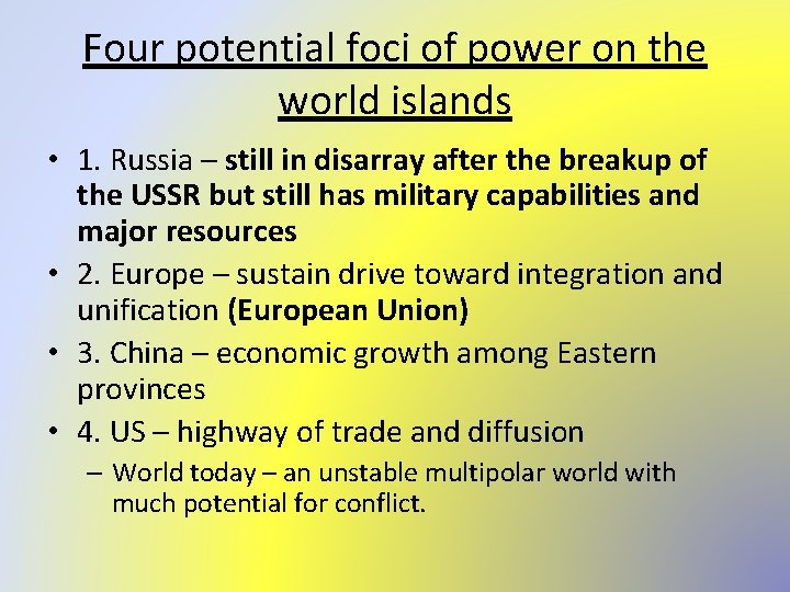
Four potential foci of power on the world islands • 1. Russia – still in disarray after the breakup of the USSR but still has military capabilities and major resources • 2. Europe – sustain drive toward integration and unification (European Union) • 3. China – economic growth among Eastern provinces • 4. US – highway of trade and diffusion – World today – an unstable multipolar world with much potential for conflict.

Unilateralism • Unilateralism- United States has been practicing this by having allies follow rather than join the political decision making process • Historically, unilateral or single polar worlds have not had one country stay in power for long • Only time will tell if the US can maintain its dominance on the world’s economy, politics, & military

IV. What are Supranational Organizations, and What is the Future of the State? • Supranationalism – a venture involving three or more national states involving political, economic and or cultural cooperation to promote shared objectives. Forge associations for mutual benefit and pursuit of shared goals. Ex: European Union • The more states participate in multilateral associations, less likely they are to act alone in pursuit of self interest. • Approximately 100 multilateral associations

International Sanctions • Designed to induce states to change their behavior • Isolate a country that behaves in a way that is deemed inappropriate by the international community – trade sanctions • Example- in 1980 s sanctions on South Africa to end apartheid

From League of Nations to United Nations • End of WWI – was the beginning of the supranational movement • League of Nations created in 1919 • Formed to try to prevent future aggression • Only 63 states joined, US never joined (even though Woodrow Wilson came up with the idea) • The U. S. did not join because the Senate was opposed. • Collapsed as WWII began • Italy/Ethiopia – failed to act when Italy was about to invade Ethiopia • Initiated international negotiations on maritime boundaries and laws of the sea

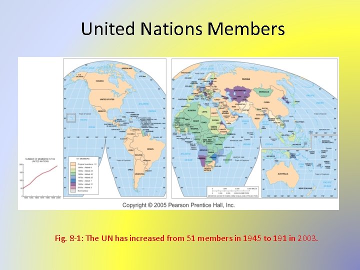
The United Nations • After the end of WWII – formed to help with international security and cooperation • After WWII ended the United Nations was formed. • The United States did join. • A handful of states still do not belong but in 2002 the United Nations had 191 member states. • The UN has subsidiaries such as FAO (Food and Agriculture Organization), UNESCO (United Nations Educational, Scientific and Cultural Organization) and WHO (World Health Organization) • Membership in the UN can not be revoked regardless of behavior • Some states violate the standards in the UN charter (South Africa, Iraq)

Peacekeeping Organizations • Help with internal conflicts, monitor elections and care for refugees • The UN is not a world government; member states participate voluntarily. • Peacekeeping has become a costly and controversial UN responsibility. • The UN does not have its own army. • All UN troops are made up of soldiers assigned to UN duty by their member states. • Often problems arise as to the leadership of the UN peacekeepers.

United Nations Members Fig. 8 -1: The UN has increased from 51 members in 1945 to 191 in 2003.

Regional Multinational Unions and the European Union • Multinational unions are when states join together to further their shared political ideologies economic objectives and strategic goals. • Benelux - the first experiments in interstate cooperation were in Europe with the Netherlands, Belgium and Luxembourg. • After WWII when Europe was trying to rebuild a committee representing 16 Western European states worked with the US to create what became know as the Marshall Plan. It gave Europe $12 billion to rebuild. It helped move European states toward cooperation.

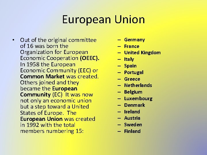
European Union • Out of the original committee of 16 was born the Organization for European Economic Cooperation (OEEC). In 1958 the European Economic Community (EEC) or Common Market was created. Others joined and they became the European Community (EC) It was now not only an economic union but a step toward a United States of Europe. The European Union was created in 1992 with the total members numbering 15: – – – – Germany France United Kingdom Italy Spain Portugal Greece Netherlands Belgium Luxembourg Denmark Ireland Austria Sweden Finland

• On January 1, 2002 the euro coins and notes were introduced. • Problems that arise in the EU • Difficulty for integration because of the diversity of the countries. • Maintaining a balance of power • As the EU expands eastward economically weak and often unstable countries may wish to join the EU such as Turkey and Bulgaria

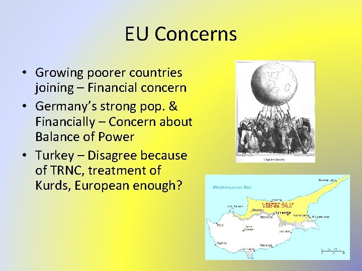
EU Concerns • Growing poorer countries joining – Financial concern • Germany’s strong pop. & Financially – Concern about Balance of Power • Turkey – Disagree because of TRNC, treatment of Kurds, European enough?

Supranationalism Elsewhere • The North American Free Trade Agreement (NAFTA) was created in 1994. It links Canada, the US and Mexico in an economic community. Their goals are to eliminate trade barriers, free movement of labor, a centralized fiscal policy and a coordinated foreign policy. • Others: Caribbean Community(CARICOM) or Association of Caribbean States (ACS), Andean group and Southern Cone Community Market(MERCOSUR), Economic Community of West African States (ECOWAS), Asia-Pacific Economic Council(APEC), Commonwealth of Independent States (CIS) which are composed of former republics of the USSR.

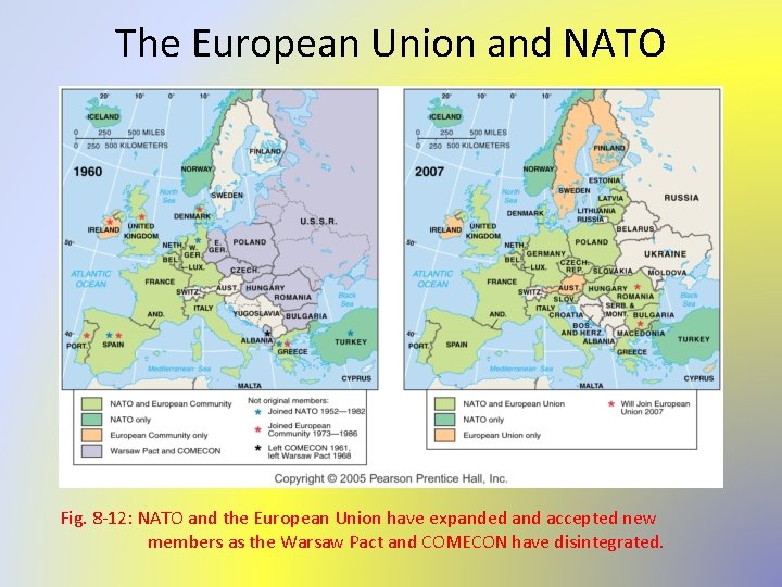
The European Union and NATO Fig. 8 -12: NATO and the European Union have expanded and accepted new members as the Warsaw Pact and COMECON have disintegrated.

Continued. . . • The North Atlantic Treaty Organization (NATO) was a formation of a military alliance. It led to the creation of the Warsaw Treaty which combined the USSR and its Eastern European satellites into an opposing military alliance. It is now defunct. • The African Union is said to be a cultural alliance to promote shared goals. Another cultural organization is the Arab League which is an alliance of Muslim states in North Africa and Southwest Asia. • Others are political, but without economic underpinnings they tend to be short lived.
 Ap human geography frq format
 Stateless nation
 Process organization in computer organization
 Block organization and point by point organization
 Nicholas spykman rimland theory
 How did darius i change persia's political organization
 Political organization of space definition
 Geri flanary
 Political party organization chart
 5 themes of geography ap human geography
 Classification of boundaries in political geography
 Objectives of political geography
 Population density map australia
 Relationship between political science and geography
 Europe 1990 map
 Boundaries ap human geography
 Political geography
 Political geography
 Centripetal vs centrifugal force geography
 Levels of ecological organization
 World history and geography final exam study guide
 Advanced higher geography understanding standards
 Temperate region
 Geography paper 1 case studies aqa
 Africa geography unit test study guide
 Igcse geography case study questions
 Essential skills to study geography
 Ba geography study material
 Sue earle farm
 Fbla-pbl state chapters usually have a number of elected
 Ecological study vs cohort study
 Retrospective cohort study
 What is work study in management
 Marty lobdell study less study smart
 Phytogeographical regions of india
 Distinguish between motion study and time study
 Distinguish between time study and motion study
 Hình ảnh bộ gõ cơ thể búng tay
 Frameset trong html5
 Bổ thể
 Tỉ lệ cơ thể trẻ em
 Gấu đi như thế nào
 Chụp phim tư thế worms-breton
 Bài hát chúa yêu trần thế alleluia
 Môn thể thao bắt đầu bằng chữ đua
 Thế nào là hệ số cao nhất
 Các châu lục và đại dương trên thế giới
 Cong thức tính động năng
 Trời xanh đây là của chúng ta thể thơ
 Mật thư tọa độ 5x5
 Làm thế nào để 102-1=99
 Phản ứng thế ankan
 Các châu lục và đại dương trên thế giới
 Thơ thất ngôn tứ tuyệt đường luật
 Quá trình desamine hóa có thể tạo ra
 Một số thể thơ truyền thống
 Cái miệng bé xinh thế chỉ nói điều hay thôi
 Vẽ hình chiếu vuông góc của vật thể sau
 Nguyên nhân của sự mỏi cơ sinh 8
 đặc điểm cơ thể của người tối cổ
 Giọng cùng tên là
 Vẽ hình chiếu đứng bằng cạnh của vật thể
 Phối cảnh
 Thẻ vin
 đại từ thay thế
 điện thế nghỉ
 Tư thế ngồi viết
 Diễn thế sinh thái là
 Dot
Dot Các số nguyên tố
 Tư thế ngồi viết
 Lời thề hippocrates
 Thiếu nhi thế giới liên hoan
 ưu thế lai là gì
 Sự nuôi và dạy con của hổ
 Khi nào hổ mẹ dạy hổ con săn mồi
 Sơ đồ cơ thể người
 Từ ngữ thể hiện lòng nhân hậu
 Thế nào là mạng điện lắp đặt kiểu nổi
 Transition words
 Function of world trade organization
 World nature organization
 Supervisory organisation
 09 schanlan street, uitenhage
 Computer organization and architecture 10th solution
 Pentium 4 cache organization
 Semiconductor ram memories in computer organization
 Role of business manager in an organization
 What is an organization
 Organization chart of large hotel
 Software engineering virtual lab iit kharagpur
 Army structure
 Usamraa
