Requirements for a Major Snowstorm That Incorporates Heavy
- Slides: 82

Requirements for a Major Snowstorm That Incorporates Heavy Snow Event (HSE) Criteria in the Philadelphia Metropolitan Area Widespread Snowstorm in the Delaware Valley (southeast PA, southern NJ away from the coastal regions, northern DE, and northeast MD) of 8 inches or more in a 24 hour period

Thank You • Very special thanks to two prominent figures in the meteorological business—Glenn “Hurricane” Schwartz and David Tolleris. Without them, this work would NOT be possible. I hold these gentlemen in high esteem and admire their work and expertise immensely. NBC-10 Chief Meteorologist Glenn “Hurricane” Schwartz initiated the idea of a major snowstorm decision tree for the eastern seaboard (checklist) in the 1980’s. Meteorologist David Tolleris expanded on the original prototype and has applied such checklists to his forecasts. The professional feedback I received from them during this research endeavor was greatly appreciated. Their continued support and collaboration in reference to ongoing meteorological issues is priceless and I am extremely grateful for their contributions. Additionally, thanks also to Larry Cosgrove, Paul Kocin, Louis Uccellini, Henry Margusity, Rob Guarino, Norman Wes Junker, HM, Bill Conlin, Joe Bastardi, and Kathy Orr for their peer review and feedback.

Storm Checklist • • • State of the NAO 50 -50 Low Polar Vortex Character of 500 h. Pa Trough Character of Surface Low Pressure Character of Surface High Pressure 850 h. Pa Low Strength 850 h. Pa Low Track Low Level Cold Air Other Factors: (700 h. Pa Low Track, 700 h. Pa Low Strength, PNA Pattern, MJO Phase, EPO Index, ENSO, Southeast Ridge, Ocean Temperatures, Moon Phases, Weekend Rule, Phases of a Snowstorm, and Local Climatology)

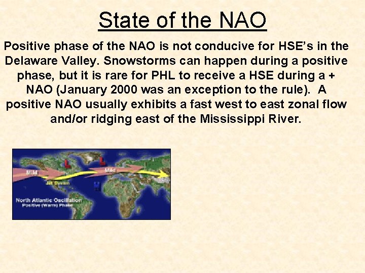
State of the NAO Positive phase of the NAO is not conducive for HSE’s in the Delaware Valley. Snowstorms can happen during a positive phase, but it is rare for PHL to receive a HSE during a + NAO (January 2000 was an exception to the rule). A positive NAO usually exhibits a fast west to east zonal flow and/or ridging east of the Mississippi River.

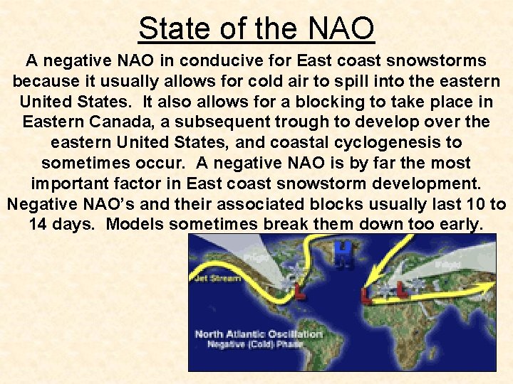
State of the NAO A negative NAO in conducive for East coast snowstorms because it usually allows for cold air to spill into the eastern United States. It also allows for a blocking to take place in Eastern Canada, a subsequent trough to develop over the eastern United States, and coastal cyclogenesis to sometimes occur. A negative NAO is by far the most important factor in East coast snowstorm development. Negative NAO’s and their associated blocks usually last 10 to 14 days. Models sometimes break them down too early.

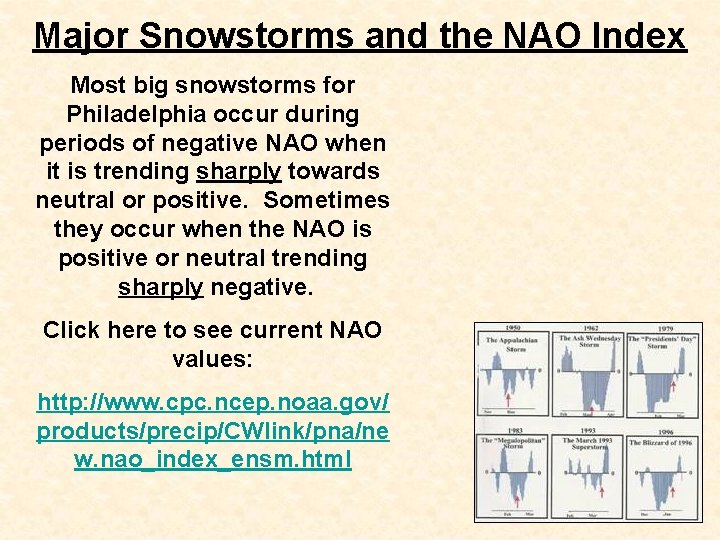
Major Snowstorms and the NAO Index Most big snowstorms for Philadelphia occur during periods of negative NAO when it is trending sharply towards neutral or positive. Sometimes they occur when the NAO is positive or neutral trending sharply negative. Click here to see current NAO values: http: //www. cpc. ncep. noaa. gov/ products/precip/CWlink/pna/ne w. nao_index_ensm. html

Major Snowstorms and the NAO Index The NAO index at times can be deceiving. For example, the NAO can be negative (good for snowstorms) yet there could be no classic Greenland block (High Pressure over Greenland). The block is instead situated elsewhere or not in the most favorable position for northern Mid-Atlantic snowstorms. Also, the NAO index can be extreme negative which can prompt a suppression of storms. In this case, the lower Mid. Atlantic and/or southeastern states could receive the heaviest snow. Therefore, when it comes to the NAO, the following must be taken into consideration. 1. Negative or positive? 2. Trend? 3. How negative or positive? 4. What type of NAO? Where is the block?

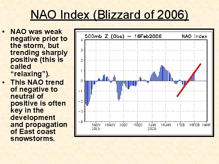
NAO Index (Blizzard of 2006) • NAO was weak negative prior to the storm, but trending sharply positive (this is called “relaxing”). • This NAO trend of negative to neutral of positive is often key in the development and propagation of East coast snowstorms.

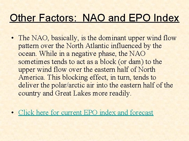
Other Factors: NAO and EPO Index • The NAO, basically, is the dominant upper wind flow pattern over the North Atlantic influenced by the ocean. While in a negative phase, the NAO sometimes tends to act as a block (or dam) to the upper wind flow over the eastern half of North America. This blocking effect, in turn, tends to deliver the polar/arctic air into the eastern half of the country and Great Lakes more readily. • Click here for current EPO index and forecast

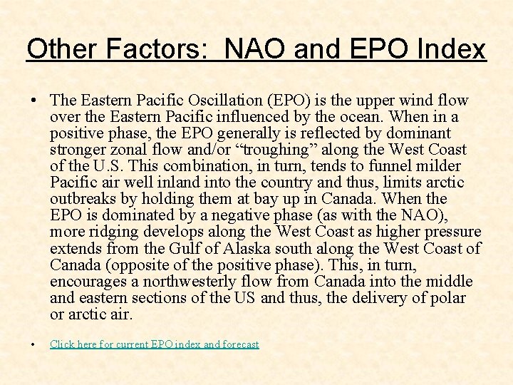
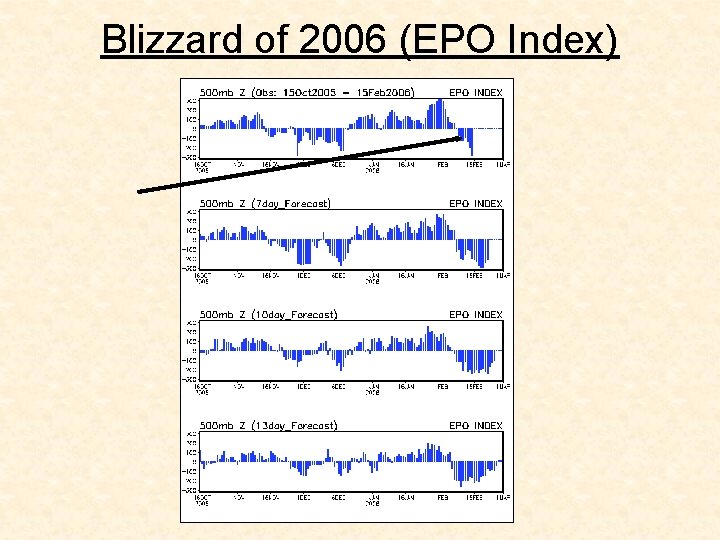
Other Factors: NAO and EPO Index • The Eastern Pacific Oscillation (EPO) is the upper wind flow over the Eastern Pacific influenced by the ocean. When in a positive phase, the EPO generally is reflected by dominant stronger zonal flow and/or “troughing” along the West Coast of the U. S. This combination, in turn, tends to funnel milder Pacific air well inland into the country and thus, limits arctic outbreaks by holding them at bay up in Canada. When the EPO is dominated by a negative phase (as with the NAO), more ridging develops along the West Coast as higher pressure extends from the Gulf of Alaska south along the West Coast of Canada (opposite of the positive phase). This, in turn, encourages a northwesterly flow from Canada into the middle and eastern sections of the US and thus, the delivery of polar or arctic air. • Click here for current EPO index and forecast

Blizzard of 2006 (EPO Index)

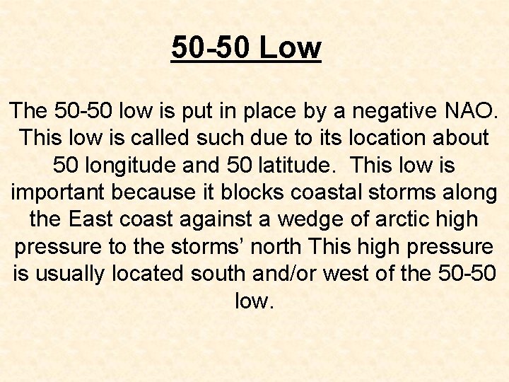
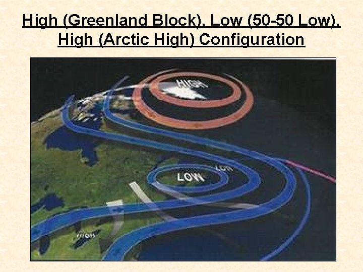
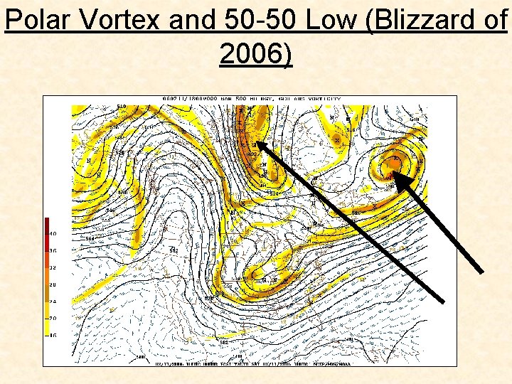
50 -50 Low The 50 -50 low is put in place by a negative NAO. This low is called such due to its location about 50 longitude and 50 latitude. This low is important because it blocks coastal storms along the East coast against a wedge of arctic high pressure to the storms’ north This high pressure is usually located south and/or west of the 50 -50 low.

50 -50 Low According to Dave Tolleris, the “ 50 -50 Low” affects the overall pattern across eastern North America in several ways. 1. Enhances the intensity or amplitude of the negative NAO in general and the Greenland Block negative NAO in particular. 2. Keeps cold air source (high pressure) in place. Trap and lock example. Thus, more precipitation falls as snow due to the prevailing NW, N, or NE wind. 3. 3. Prevents systems in Plains/Midwest from passing west of the Appalachian Mountains.

High (Greenland Block), Low (50 -50 Low), High (Arctic High) Configuration

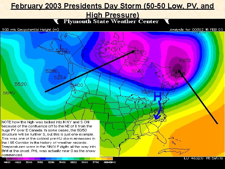
February 2003 Presidents Day Storm (50 -50 Low, PV, and High Pressure)

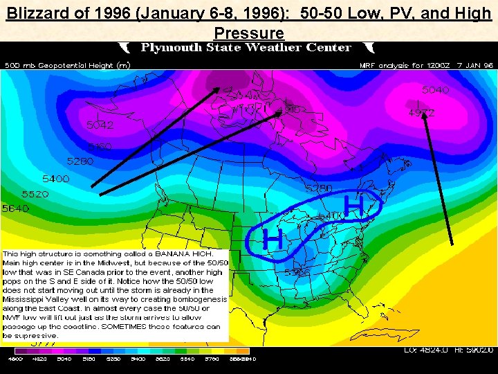
Blizzard of 1996 (January 6 -8, 1996): 50 -50 Low, PV, and High Pressure

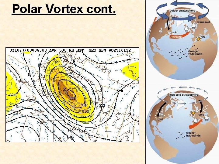
Polar Vortex • The polar vortex is analyzed at 500 millibars. The polar vortex occurs above the core of the coldest polar air. Since frigid air is dense, heights are lower aloft because cold air has a lower thickness than warmer air. • At the surface of the polar air mass will be high pressure, but low heights will occur aloft at 500 mb since the air is compacted due to high density air near the surface.

Polar Vortex cont. • The polar vortex can often be located over Canada since the coldest surface air is often found over high latitude icy/land locations. The polar vortex aloft propagates toward where the polar air mass moves. The vortex often moves very slowly or is stationary, and its position determines what part of the USA the Arctic air will invade. • When the vortex is centered over the Hudson Bay, as shown above, arctic air usually plunges south over the Dakotas and the northern Plains. If the vortex center shifts to the east, the core of the Arctic air invasion usually shifts east with it.

Polar Vortex cont. • There are many regions where the polar vortex can be located for it to be marginally conducive for East coast snowstorms. Most important is that the PV is on our side of the northern hemisphere and away from the pole (displaced). • However, in my opinion, the polar vortex is best situated in southeastern Canada just prior to an East Coast snowstorm. However, for a storm to come up the coast the PV needs to weaken and/or move out of the way (northward, northwestward, or backwards diving south and east of the pumping PNA ridge). Otherwise the storm will be suppressed to the south. North Hudson Bay, Canada is also a favorable position just prior to a snowstorm.

Polar Vortex cont. • Just keep it away from the Great Lakes region or just above it. In this position, short waves have trouble slowing down and digging (thoughts courtesy of Dave Tolleris).

Polar Vortex cont.

Polar Vortex and 50 -50 Low (Blizzard of 2006)

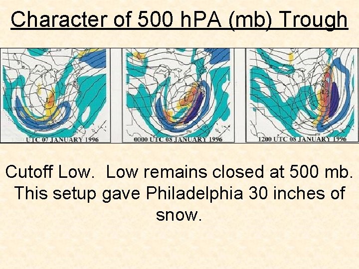
Character of 500 h. PA (mb) Trough Cutoff Low remains closed at 500 mb. This setup gave Philadelphia 30 inches of snow.

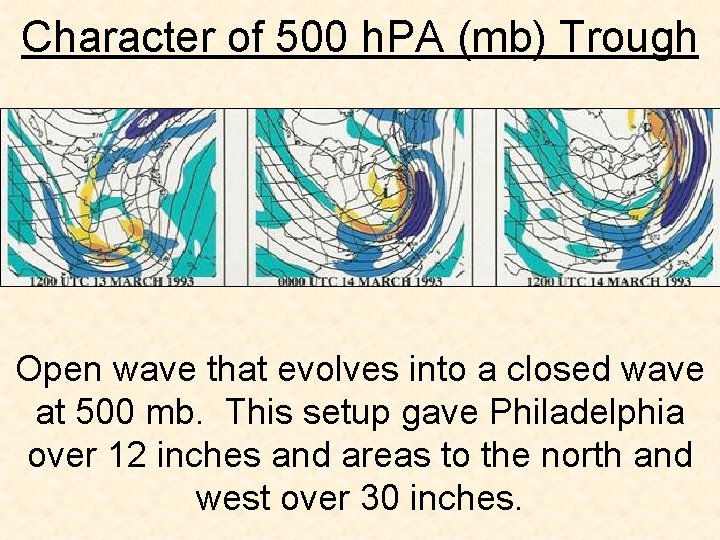
Character of 500 h. PA (mb) Trough Open wave that evolves into a closed wave at 500 mb. This setup gave Philadelphia over 12 inches and areas to the north and west over 30 inches.

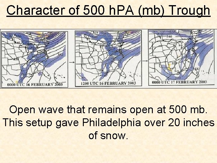
Character of 500 h. PA (mb) Trough Open wave that remains open at 500 mb. This setup gave Philadelphia over 20 inches of snow.

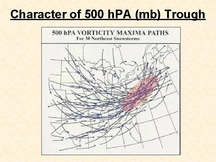
Character of 500 h. PA (mb) Trough In addition to there being a trough in the first place, the trough must exhibit specific properties to be conducive for heavy snow fall in the Philadelphia region. The 500 mb vorticity maxima needs to be south of Philadelphia and propagate in a northeastward direction near to the East coast. If the vorticity maxima propagates northeastward too far west and away from the coast, it is likely that the precipitation associated with the storm will NOT remain all snow or even mostly snow. Click here for current 500 mb chart (Chart 1) Click here for current 500 mb chart (Chart 2)

Character of 500 h. PA (mb) Trough

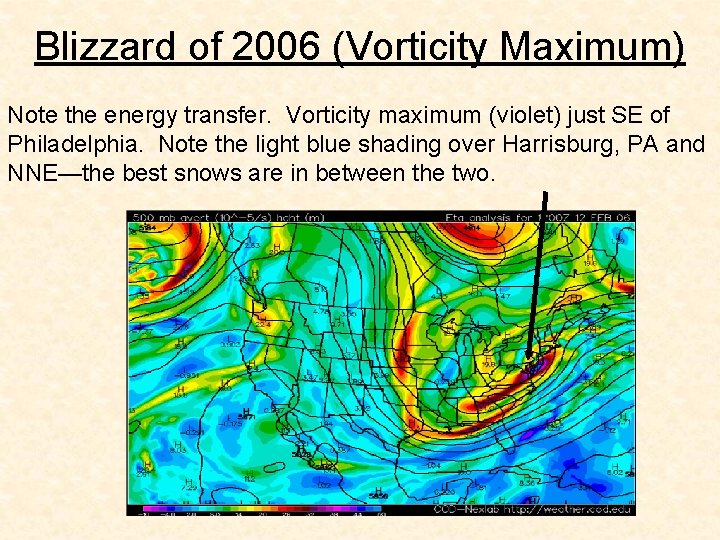
Blizzard of 2006 (Vorticity Maximum) Note the energy transfer. Vorticity maximum (violet) just SE of Philadelphia. Note the light blue shading over Harrisburg, PA and NNE—the best snows are in between the two.

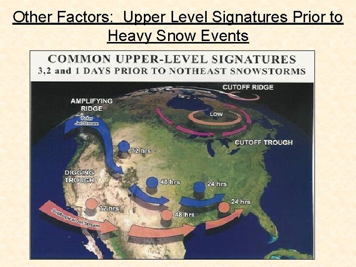
Other Factors: Upper Level Signatures Prior to Heavy Snow Events

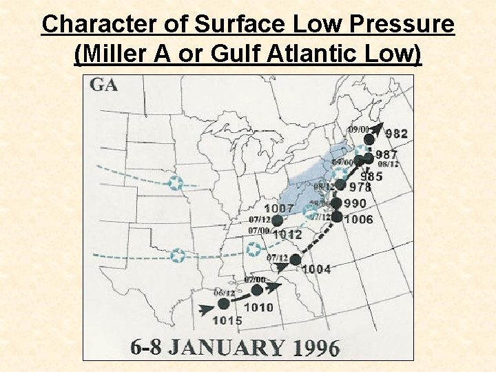
Character of Surface Low Pressure (Miller A or Gulf Atlantic Low)

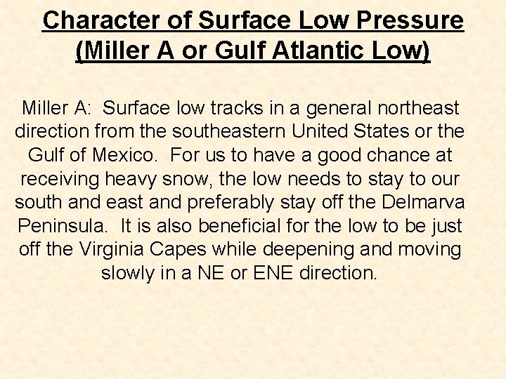
Character of Surface Low Pressure (Miller A or Gulf Atlantic Low) Miller A: Surface low tracks in a general northeast direction from the southeastern United States or the Gulf of Mexico. For us to have a good chance at receiving heavy snow, the low needs to stay to our south and east and preferably stay off the Delmarva Peninsula. It is also beneficial for the low to be just off the Virginia Capes while deepening and moving slowly in a NE or ENE direction.

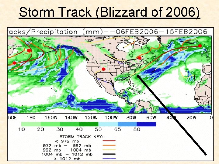
Storm Track (Blizzard of 2006)

Character of Surface Low Pressure (Miller B or Atlantic Redevelopment Low)

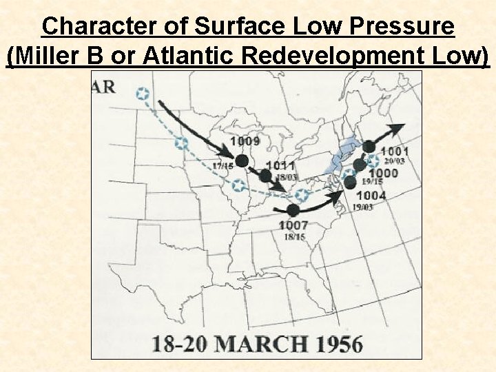
Character of Surface Low Pressure (Miller B or Atlantic Redevelopment Low) Miller B: Surface low tracks from Northern Plains or Canada and dives southeast. This low weakens while a secondary or coastal low redevelops off the East coast. For Philadelphia to receive a heavy snow fall from a Miller B low requires a unique set of characteristics. The secondary (coastal) low must form to the south and east of Philadelphia. This low must also intensify, preferably in a rapid, bomb like, fashion yet be moving slowly. This low unlike the Miller A, is best for heavy snow when it moves in a more northerly direction rather than a NE or ENE direction.

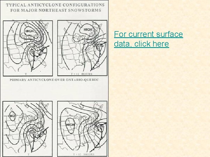
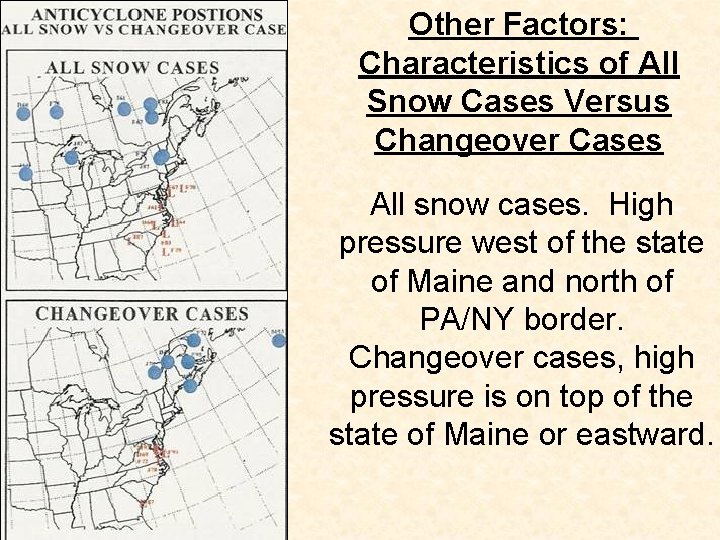
Character of Surface High Pressure An arctic high pressure is key for heavy snow to fall in Philadelphia. An arctic high pressure, if positioned correctly, and with enough strength, will aide in keeping the storm mostly snow or all snow. In addition, an arctic high pressure with good position and strength will also slow down the movement of the coastal low allowing for precipitation to fall for a longer period of time. For heavy snow events to occur in PHL, the best position for a high pressure is to the west of Maine and to the north of the PA/NY border. The high can also be located in the Northern Plains/Midwest. As far as strength goes, pressures above 1020 mb are adequate enough to provide decent low level cold air.

For current surface data, click here

850 h. Pa Low Strength and Track The strength of the upper air low, the 850 h. Pa (mb) low, is one of the factors that aides in the rapid development of a coastal low. Thus, an intensifying 850 mb low, or an already strong 850 mb low, greatly aides in the development of heavy snowfall near the Philadelphia region. This is especially true in Miller B systems. For a Miller B storm to be deemed a heavy snow event for Philadelphia it is crucial that the 850 low goes through a rapid intensification cycle. However, even more important than strength is track. The 850 h. Pa is best to the south of Philadelphia, yet north the NC/VA border moving in an easterly direction.

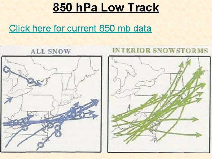
850 h. Pa Low Track Click here for current 850 mb data

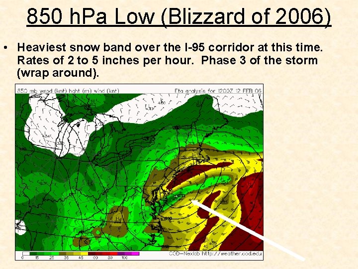
850 h. Pa Low (Blizzard of 2006) • Heaviest snow band over the I-95 corridor at this time. Rates of 2 to 5 inches per hour. Phase 3 of the storm (wrap around).

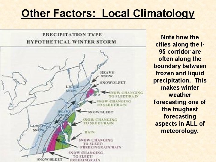
Low Level Cold Air One factor often overlooked during a heavy snow event, even when the event is going full throttle, is the amount of low level cold air. Philadelphia is a major boundary area due to its proximity to the Atlantic Ocean, Gulf Stream Current, and Appalachian Mountains. Thus, even if an arctic high pressure is in perfect position, the precipitation can still change to sleet, freezing rain, snow pellets, or rain. Thus, temperatures throughout all layers of the troposphere need to be analyzed in real time and by using numerical model guidance. Click here for local data from upper air soundings

Other Factors: Local Climatology Note how the cities along the I 95 corridor are often along the boundary between frozen and liquid precipitation. This makes winter weather forecasting one of the toughest forecasting aspects in ALL of meteorology.

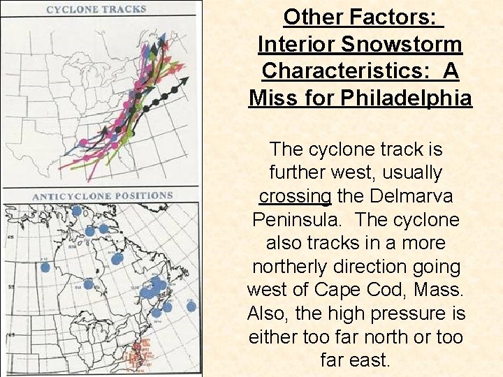
Other Factors: Interior Snowstorm Characteristics: A Miss for Philadelphia The cyclone track is further west, usually crossing the Delmarva Peninsula. The cyclone also tracks in a more northerly direction going west of Cape Cod, Mass. Also, the high pressure is either too far north or too far east.

Other Factors: Characteristics of All Snow Cases Versus Changeover Cases All snow cases. High pressure west of the state of Maine and north of PA/NY border. Changeover cases, high pressure is on top of the state of Maine or eastward.

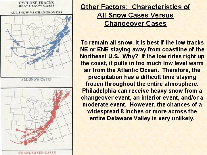
Other Factors: Characteristics of All Snow Cases Versus Changeover Cases To remain all snow, it is best if the low tracks NE or ENE staying away from coastline of the Northeast U. S. Why? If the low rides right up the coast, it pulls in too much low level warm air from the Atlantic Ocean. Therefore, the precipitation has a difficult time staying frozen throughout the entire atmosphere. Philadelphia can receive heavy snow from a changeover event, an interior event, and/or a moderate event. However, the chances of a widespread 8 inches or more across the entire Delaware Valley is very unlikely.

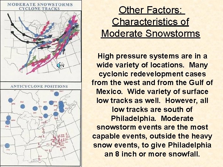
Other Factors: Characteristics of Moderate Snowstorms High pressure systems are in a wide variety of locations. Many cyclonic redevelopment cases from the west and from the Gulf of Mexico. Wide variety of surface low tracks as well. However, all low tracks are south of Philadelphia. Moderate snowstorm events are the most capable events, outside the heavy snow events, to give Philadelphia an 8 inch or more snowfall.

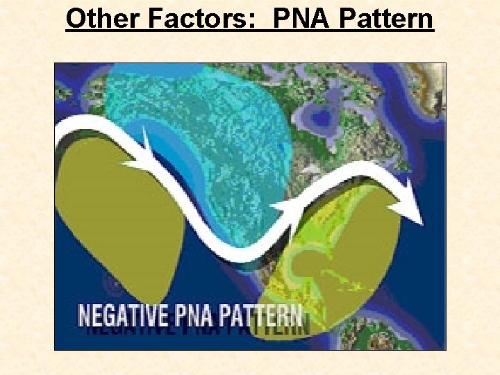
Other Factors: PNA Pattern A negative PNA pattern favors a trough along the West coast of the United States and ridging along the East coast of the United States. Thus, when the PNA is negative, the pattern is not extremely conducive for East coast snowstorms. Can snowstorms still occur along the East Coast? Yes, but the storm track still has to be south and east of Philadelphia. Best option here for snow is a negative PNA pattern with a split flow jet stream and other conducive factors in place like the 50 -50 low, negative NAO, and position of surface high pressure.

Other Factors: PNA Pattern

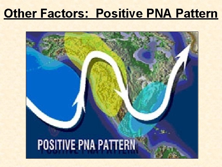
Other Factors: Positive PNA Pattern A positive PNA pattern favors a trough along the East coast of the United States and ridging along the West coast of the United States. Thus, when the PNA is positive, the pattern is conducive for East coast snowstorms. However, many other factors must be in place as well. This is the case with every single one of these points. Just one will not make a snowstorm. Having all of them in place does not mean a snowstorm will happen. However, the more you have, the better chance that exists for a heavy snow producing storm over the Delaware Valley. Click here for current PNA index values

Other Factors: Positive PNA Pattern

Other Factors: PNA Pattern Major snowstorms have occurred in the Delaware Valley during times of a negative PNA. However, it is more of a rare occurrence when compared to times of a positive PNA. If a snowstorm does develop along the East coast during a time of negative PNA, there has to be some evidence of ridging to the south and/or west to promote the digging of a trough near the East Coast. This ridging may be displaced just east of the West coast (Rockies/Plains) or sometimes as far east as the Deep South, thus the PNA remains in a negative state. Click here for current PNA index values

Other Factors: PNA Pattern Also, just as is the case with the NAO, look for which direction the index is trending. A negative PNA trending sharply neutral or positive is a good sign during times of a potential developing snowstorm. Additionally, the state of the PNA (positive or negative) when evaluating snowstorm potential becomes less of a mitigating factor during late February, and especially into March and April due to shortening wavelengths (courtesy of Donald Sutherland). Click here for current PNA index values

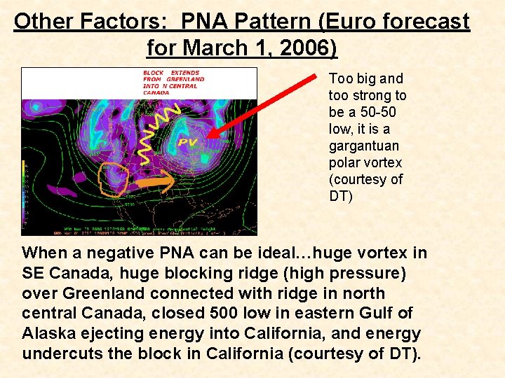
Other Factors: PNA Pattern (Euro forecast for March 1, 2006) Too big and too strong to be a 50 -50 low, it is a gargantuan polar vortex (courtesy of DT) When a negative PNA can be ideal…huge vortex in SE Canada, huge blocking ridge (high pressure) over Greenland connected with ridge in north central Canada, closed 500 low in eastern Gulf of Alaska ejecting energy into California, and energy undercuts the block in California (courtesy of DT).

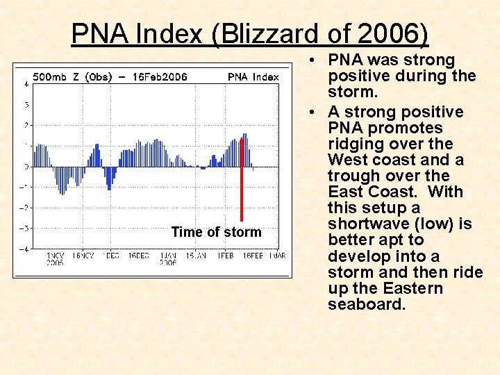
PNA Index (Blizzard of 2006) Time of storm • PNA was strong positive during the storm. • A strong positive PNA promotes ridging over the West coast and a trough over the East Coast. With this setup a shortwave (low) is better apt to develop into a storm and then ride up the Eastern seaboard.

Other Factors: Index Combination • The NAO, and PNA are all important indices when it comes to forecasting a large scale snow event. Some professionals say that a negative NAO, negative AO, and neutral PNA are very favorable for mid-Atlantic snows because the storms crash into the Pacific coast, come east and hit a block, which in turn slows them down with cold air in place, making it favorable for snow. However, I feel the best situation for a large snowstorm in the PHL area is the following: 1. Negative NAO trending positive or trending negative (very steep slope) 2. PNA trending positive (very steep slope) 3. AO negative

Other Factors: Index Combination 1. Negative NAO trending positive (very steep slope) http: //www. cpc. ncep. noaa. gov/products/precip/CWlink/pna/ new. nao_index_ensm. html 2. PNA trending positive (very steep slope) http: //www. cpc. ncep. noaa. gov/products/precip/CWlink/pna/ new. pna_index_ensm. html 3. AO negative http: //www. cpc. ncep. noaa. gov/products/precip/CWlink/dail y_ao_index/ao_index_ensm. shtml According to a senior forecaster at NOAA, “negative AO and NAO favor big snowstorms somewhere in or near the eastern U. S. but the chances at a given location are still rather small. "

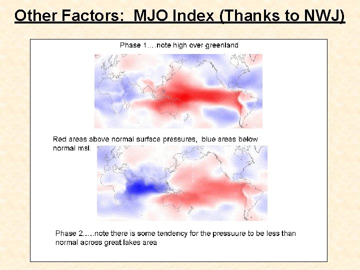
Other Factors: MJO Index Madden Julian Oscillation (MJO): A 40 - to 60 -day period of alternately strong or weak trade winds that normally blow west. It is named after Roland Madden and Paul Julian, two scientists from the National Center for Atmospheric Research who in 1971 were studying wind patterns in the tropical Pacific. For unknown reasons, these tropical winds sometimes weaken, and the Sun-warmed pulse of ocean water that they usually cause to drift west drifts east. As this pulse of warm water, called a Kelvin wave, moves east-from the coast of Africa across the Indian and Pacific Oceans-it carries changed air patterns above it.

Other Factors: MJO Index When the wave crashes into South America, the water stops, but the air pattern continues over land northeastward, into the Caribbean atmosphere and across the Atlantic Ocean. Before this cycle is complete, another pulse has already started in the Indian Ocean. Scientists are still studying the MJO. Most agree, however, that when the MJO cycle speeds up and warm Kelvin waves pile up in the Pacific Ocean, we have the start of an El Niño. The MJO usually brings flooding rains (also known as the "Pineapple Express") to the Pacific Northwest and California. In an active hurricane season on the East Coast, it can mean several hurricanes within a few weeks, followed by a long spell with no hurricanes.

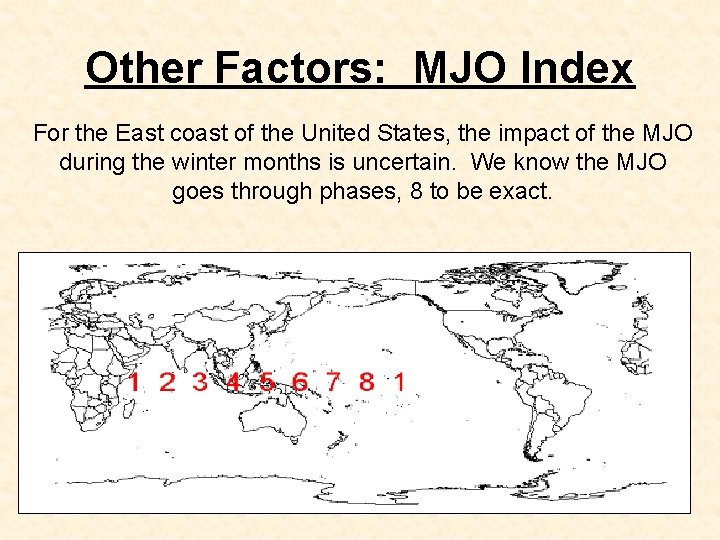
Other Factors: MJO Index For the East coast of the United States, the impact of the MJO during the winter months is uncertain. We know the MJO goes through phases, 8 to be exact.

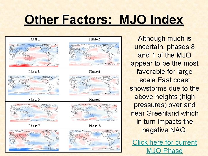
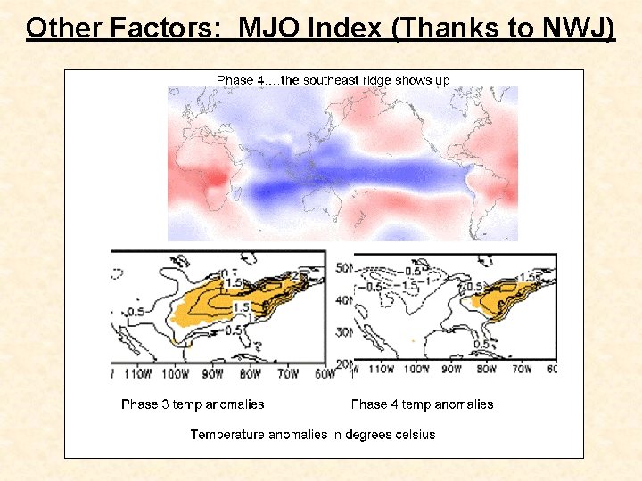
Other Factors: MJO Index Although much is uncertain, phases 8 and 1 of the MJO appear to be the most favorable for large scale East coast snowstorms due to the above heights (high pressures) over and near Greenland which in turn impacts the negative NAO. Click here for current MJO Phase

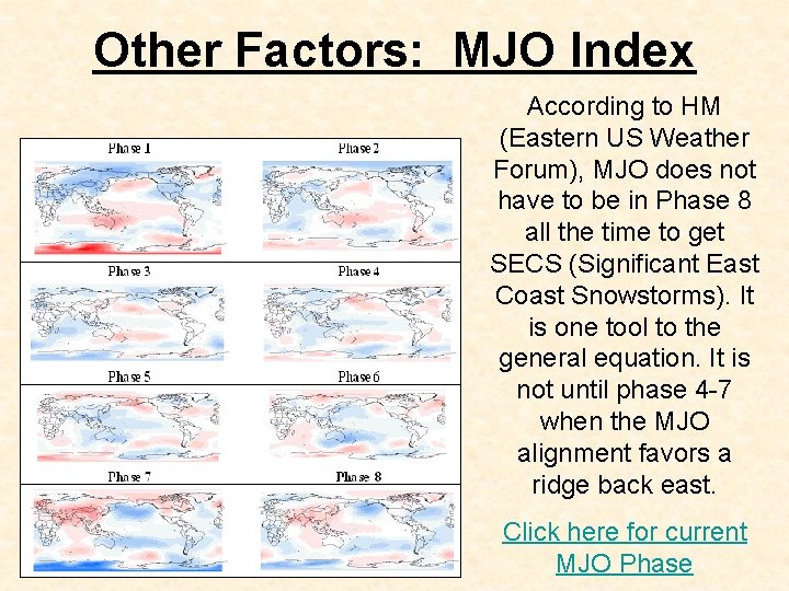
Other Factors: MJO Index According to HM (Eastern US Weather Forum), MJO does not have to be in Phase 8 all the time to get SECS (Significant East Coast Snowstorms). It is one tool to the general equation. It is not until phase 4 -7 when the MJO alignment favors a ridge back east. Click here for current MJO Phase

Other Factors: MJO Index (Thanks to NWJ)

Other Factors: MJO Index (Thanks to NWJ)

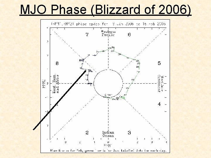
MJO Phase (Blizzard of 2006)

Other Factors: 700 mb Analysis Many of the same processes analyzed on the 850 chart are also studied on the 700 mb chart. The trough/ridge pattern becomes more defined at the 700 mb levels as compared to lower levels. A trough is simply a southern "bulge" in height contours while a ridge is a northerly displaced "bulge". This "bulge" can be large (such as in association with a mid-latitude cyclone) or small (such as a shortwave).

Other Factors: 700 mb Analysis When examining model data at 700 millibars it is common for them to show upward vertical velocity. A good forecast strategy is to look at the 700 mb forecast panels for the upward vertical velocity distribution, then determine what forces in the atmosphere are causing the upward (or downward) vertical velocities.

Other Factors: 700 mb Analysis (1) Find areas with low dewpoint depressions. Often this indicates a deep layer of moisture. Use 700 mb chart in combination with sfc and 850 charts to determine depth of moisture (2) Determine strength of warm air advection, cold air advection, and moisture advection. Thermal advection is a function of wind speed, wind direction, thermal gradient, and isotherm angle of intersection with height contours (3) Determine strength of high pressure/ low pressure. Strong organizing low pressures tilt toward the northwest with height.

Other Factors: 700 mb Analysis (4) Locate shortwaves. Determine if shortwave is barotropic or baroclinic. Baroclinic shortwave is more likely to produce precipitation. Rain and storms are generally on exit sector of shortwave. Compare shortwave with other levels in the atmosphere. Rain is likely to right of shortwave especially if dewpoint depressions are low. (5) Weather is warmer than normal under ridges and cooler than normal under troughs.

Other Factors: 700 mb Analysis Click on this site for 700 mb initialization and forecasts. http: //weather. unisys. com/eta/init/eta_700_init. html (6) Look for the greatest height falls and height rises; these values give clues to how the trough/ridge pattern will change through time. (7) 700 mb front is found where height contours kink; kinking height contours may also be a shortwave (especially if thermal advection is present). A short wave can be an upper level front.

Other Factors: 700 mb Analysis According to Henry Margusity of Accu. Weather, “the position of the 700 mb low is critical for snow in Philly. The 700 mb represents the mid layer conveyer belt that brings in moisture to the west of the storm over cold air. It the 700 mb low tracks just over, then Philly will be in good position for snow. ”

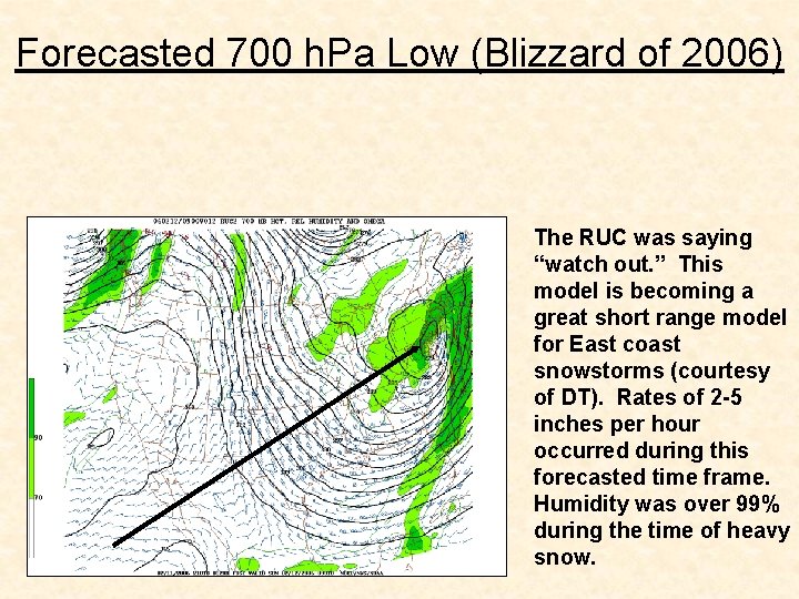
Forecasted 700 h. Pa Low (Blizzard of 2006) The RUC was saying “watch out. ” This model is becoming a great short range model for East coast snowstorms (courtesy of DT). Rates of 2 -5 inches per hour occurred during this forecasted time frame. Humidity was over 99% during the time of heavy snow.

Other Factors: Southeast Ridge Always watch out for the Southeast heat ridge. La Nina winters can be characterized by a persistent southeast ridge (high pressure). They can manifest at any time and can be killers for major snows in Philadelphia when the rest of the pattern is favorable (i. e. negative NAO etc. )

Other Factors: El Nino and La Nina Our snowiest winters are usually weak or moderate El Nino winters. The phenomena of El Nino and La Nina greatly impact the location and strength of the Pacific jet stream. This jet stream, at times, may have a great influence on our weather. For example, January of 2006 was so very mild due to the strength of the Pacific jet stream (QBO) blasting into the West Coast in a west to east fashion. This allowed the air flow to be in a primarily west to east fashion across the continental United States rather than in a cooler north to south fashion.

Other Factors: Teleconnections “It’s not one teleconnection (indices etc. ), it is all the players on the field that count (Joe Bastardi of Accu-Weather). ” “For it drives home a point about broad brushing ideas. The negative NAO is a signal for cold, but unless everything is just right, it is something that drives storms south (Joe Bastardi of Accu-Weather on March 22, 2006). ”

Other Factors: Teleconnections In other words, a negative NAO does not make a snowstorm. A positive PNA does not make a snowstorm. A negative NAO and a positive PNA together do not make a snowstorm. Patterns make snowstorms. A conglomeration of indices create the framework on which a pattern can be built.

Other Factors: The Importance of the Ocean The prevailing winds over a region prior to a storm, the expected prevailing winds over a region during a storm, the temperature of the Atlantic Ocean, and the character of the Gulf Stream current always play a role in storm development, propagation, and precipitation type. These factors must always be taken into account prior to a storm taking place that is expected to propagate and intensify along the East coast of the United States. Click here for current ocean temperatures

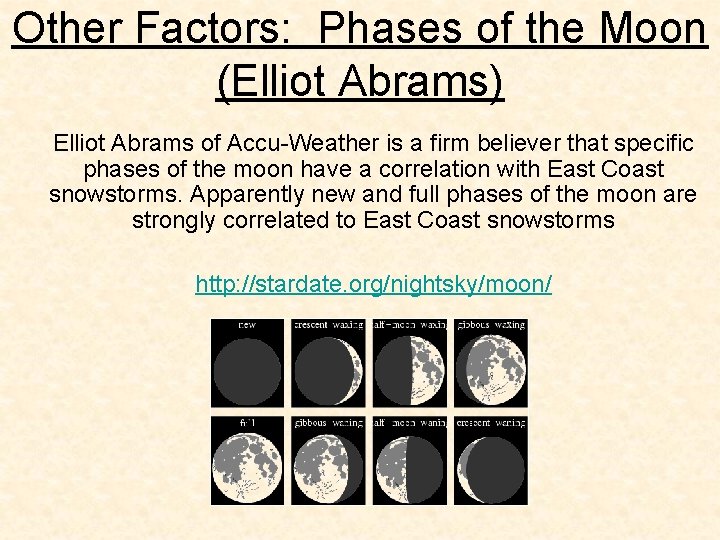
Other Factors: Phases of the Moon (Elliot Abrams) Elliot Abrams of Accu-Weather is a firm believer that specific phases of the moon have a correlation with East Coast snowstorms. Apparently new and full phases of the moon are strongly correlated to East Coast snowstorms http: //stardate. org/nightsky/moon/

Other Factors: Weekend Rule (Dave Tolleris) • There is as interesting rule or oddity that exists with Significant East Coast Snowstorms that several meteorologists have noted over the past several years. If you go back and research snowstorm events from 1955 to 1987 and you include the recent events you'll find that the all snow events (no mixing) along the I-95 corridor cities – Richmond, Washington D. C. , Baltimore, Philadelphia, New York City, New Haven, Providence, and Boston--- those events of all occurred on a weekend. • All except for 2 events. Really. I call this the “I-95 SECS WEEKEND RULE. ” Now that being said let's keep the few criteria or parameters. . . a weekend event would be a snowstorm that started on a Friday and ended on a Saturday. . . OR began on a Saturday and ended on a Sunday. . . OR began on a Sunday and ended on a Monday.

Other Factors: Weekend Rule (Dave Tolleris) • This oddity does not apply to snowstorms in the lower. Mid Atlantic -- say Virginia, D. C. , Lower Maryland, and NC. . . nor does it apply to interior snowstorms. Given those parameters the fact is every single major I 95 PURE snowstorm -- has occurred on a weekend. Everyone since 1900 except for 2. . • I am sure you recall January 96 blizzard--it was a Saturday into Sunday into Monday event. . . and the ”President's Day II” snowstorm FEB 16 -17, 2003 was also a weekend major east coast Snowstorm (MECS).

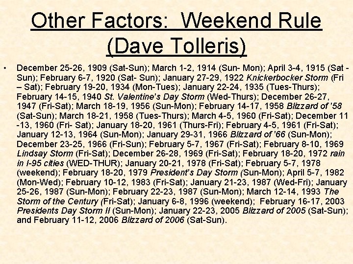
Other Factors: Weekend Rule (Dave Tolleris) • December 25 -26, 1909 (Sat-Sun); March 1 -2, 1914 (Sun- Mon); April 3 -4, 1915 (Sat Sun); February 6 -7, 1920 (Sat- Sun); January 27 -29, 1922 Knickerbocker Storm (Fri – Sat); February 19 -20, 1934 (Mon-Tues); January 22 -24, 1935 (Tues-Thurs); February 14 -15, 1940 St. Valentine's Day Storm (Wed-Thurs); December 26 -27, 1947 (Fri-Sat); March 18 -19, 1956 (Sun-Mon); February 14 -17, 1958 Blizzard of '58 (Sat-Sun); March 18 -21, 1958 (Tues-Thurs); March 4 -5, 1960 (Fri-Sat); December 11 -13, 1960 (Fri- Sat); January 18 -20, 1961 (Thurs-Fri); February 4 -5, 1961 (Fri-Sat); January 12 -13, 1964 (Sun-Mon); January 29 -31, 1966 Blizzard of '66 (Sun-Mon); December 23 -25, 1966 (Fri-Sun); February 5 -7, 1967 (Fri-Sat); February 8 -10, 1969 Lindsay Storm (Fri-Sat); December 26 -28, 1969 (Fri-Sat); February 18 -20, 1972 rain in I-95 cities (WED-THUR); January 20 -21, 1978 (Fri-Sat); February 5 -7, 1978 (weekend); February 18 -20, 1979 President's Day Storm (Sun-Mon); April 5 -7, 1982 (Mon-Wed); February 10 -12, 1983 (Fri-Sat); January 21 -23, 1987 (Wed-Fri); January 25 -26, 1987 (Sun-Mon); February 22 -23, 1987 (Sun-Mon); March 12 -14, 1993 The Storm of the Century (Fri-Sat); January 6 -8, 1996 (weekend); February 16 -17, 2003 Presidents Day Storm II (Sun-Mon); January 22 -23, 2005 Blizzard of 2005 (Sat-Sun); and February 11 -12, 2006 Blizzard of 2006 (Sat-Sun).

Other Factors: Weekend Rule (Dave Tolleris) • The March 12 -13 historical 1888 blizzard was a Sunday to Monday event, the Feb 12 -14 1899 severe East Coast snowstorm that was part of an arctic outbreak of historic proportions occurred on a Friday to Sunday. The Ash Wednesday severe Nor’easter of March 5 -7 occurred on a Monday to Wednesday and it was a rain event for most of East Coast I-95 cities. • Interestingly this oddity does not apply for mid-Atlantic snowstorms. For example the January 24 -25 2000 severe Nor’easter which dumped some 21" snow in Charlotte and greater than 6" of snow in much of South Carolina, 15"- 18" in central Virginia and 12" of snow in DC. . . only dropped 6" in Philly, New York City, and Boston, and it was a Monday Tuesday event. • Of course there is a reason WHY this "oddity" exists. If we include the periods of Friday to Saturday, Saturday to Sunday, and Sunday to Monday. . that is 3 days out of 7. Even so it does seem a little unlikely thing.

Other Factors: Local Climatology One must always know his local climatology. Computer models do not have an understanding for the past or a comprehension of a regions local climate character. When issuing a forecast that has a possibility of fulfilling an extreme solution, do some research. Know your area’s complete snow history and know what factors need to either be in place before the storm, or what factors need to manifest themselves during a storm to fulfill such an extreme solution. Take into account what month it is and what day of the week it is. Take into account how often, on average, storms of a certain magnitude occur. Far too often a computer model(s) is (are) taken verbatim before the most basic physics, meteorology, and climatology are ever even taken into consideration and applied to the possible outcome. One meteorologist who is fantastic at doing this in a very thorough and often humorous manner is Dave Tolleris. http: //www. ncdc. noaa. gov/ussc/pagemap. html

Typical Snowstorm : 3 Chances at Receiving Accumulating Snow A typical snowstorm has 3 phases or parts that can deliver accumulating snow to a specified region. Phase 1 = overrunning snow Phase 2 = storm snow Phase 3 = wrap around snow Simply put, the more phases you experience in a given region, the higher the likelihood is that region “x” will receive a major snowfall. Thoughts on this slide courtesy of Glenn “Hurricane” Schwartz