Equation of State a k a the Ideal
 pressure (N m-2) temperature")


 Suppose a parcel exchanges no energy with its surroundings")


 •")


 • Ice binds water molecules more")


 strong wind gust under rainfree cloud; (2)")


- Slides: 46
Equation of State (a. k. a. the “Ideal Gas Law”) pressure (N m-2) temperature (K) density (kg m-3) “gas constant” (J K-1 kg-1) • Direct relationship between density and pressure • Inverse relationship between density and temperature • Direct relationship between temperature and pressure
Pressure and Density • Gravity holds most of the air close to the ground • The weight of the overlying air is the pressure at any point
Hydrostatic Balance What keeps air from always moving downwards due to gravity? A balance between gravity and the pressure gradient force. DP/ Dz = rg rg The “pressure gradient force? ” Pushes from high to low pressure.
Buoyancy An air parcel rises in the atmosphere when its density is less than its surroundings Let renv be the density of the environment. From the Ideal Gas Law renv = P/RTenv Let rparcel be the density of an air parcel. Then rparcel = P/RTparcel Since both the parcel and the environment at the same height are at the same pressure – when Tparcel > Tenv Tparcel < Tenv rparcel < renv (positive buoyancy) rparcel > renv (negative buoyancy)
Stable and Unstable Equilibria Stable Unstable Neutral Conditionally Stable • Stable: when perturbed, system accelerates back toward equilibrium state • Unstable: when perturbed, system accelerates away from equilibrium state
Stability in the atmosphere An Initial Perturbation Stable Unstable Neutral If an air parcel is displaced from its original height it can: Return to its original height - Stable Accelerate upward because it is buoyant - Unstable Stay at the place to which it was displaced - Neutral
Why is stability important? Vertical motions in the atmosphere a critical part of energy transport and strongly influence the hydrologic cycle • Without vertical motion, there would be no precipitation, no mixing of pollutants away from ground level - weather as we know it would simply not exist! • There are two types of vertical motion: – forced motion such as forcing air up over a hill, over colder air, or from horizontal convergence – buoyant motion in which the air rises because it is less dense than its surroundings
Trading Height for Heat (cont’d) Suppose a parcel exchanges no energy with its surroundings … we call this state adiabatic, meaning, “not gaining or losing energy” “Dry lapse rate”
Dry Lapse Rate 10 degrees C per kilometer Warming and Cooling due to changing pressure
Stability and the Dry Lapse Rate • A rising air parcel cools according to the dry lapse rate (10 C per km) • If rising, cooling air is: – warmer than surrounding air it is less dense and buoyancy accelerates the parcel upward … UNSTABLE! – colder than surrounding air it is more dense and buoyancy opposes (slows) the rising motion … STABLE!
Unstable Atmosphere • The atmosphere is unstable if the actual lapse rate exceeds the dry lapse rate (air cools more than 10 C/km) • This situation is rare in nature (not long-lived) – Usually results from surface heating and is confined to a shallow layer near the surface – Vertical mixing eliminates it • Mixing results in a dry lapse rate in the mixed layer, unless condensation (cloud formation) occurs
• The atmosphere is stable if the actual lapse rate is less than the dry lapse rate (air cools less than 10 C/km) • This situation is common in nature (happens most calm nights, esp in winter) – Usually results from surface cooling and is confined to a shallow layer near the surface – Vertical mixing or surface heating eliminates it Stable Atmosphere
Water Vapor, Liquid Water, and Air • Water molecules make phase transitions • When vapor and liquid are in equilibrium, the air is “saturated” • Saturation vapor pressure es depends only on temperature • Dewpoint temperature Td depends only on vapor pressure e
Moist Adiabatic Lapse Rate Warming and cooling due to both changes in pressure and latent heat release Rising air with condensing water cools more slowly with height than dry air
• If the environmental lapse rate falls between the moist and dry lapse rates: – The atmosphere is unstable for saturated air parcels but stable for dry air parcels – This situation is termed conditionally unstable • This is the most typical situation in the troposphere Conditionally unstable air
Condensation • Phase transformation of water vapor to liquid water • Water does not easily condense without a surface present – Vegetation, soil, buildings provide surface for dew and frost formation – Particles act as sites for cloud and fog drop formation
Cloud and fog drop formation • If the air temperature cools below the dew point (RH > 100%), water vapor will tend to condense and form cloud/fog drops • Drop formation occurs on particles known as cloud condensation nuclei (CCN) • The most effective CCN are water soluble • Without particles clouds would not form in the atmosphere! – RH of several hundred percent required for pure water drop formation
Cloud Droplets are Tiny!
Very Small Drops Evaporate! • Surface of small drops are strongly curved • Stronger curvature produces a higher esat • Very high RH required for equilibrium with small drops – ~300% RH for a 0. 1 µm pure water drop If small drops evaporate, how can we ever get large drops? !
Nucleation of Cloud Droplets • Formation of a pure water drop without a condensation nucleus is termed “homogeneous nucleation” • Random collision of water vapor molecules can form a small drop embryo – Collision likelihood limits maximum embryo size to < 0. 01 µm • esat for embryo is several hundred percent – Embryo evaporates since environmental RH < 100. 5%
Effects of Dissolved Stuff • Condensation of water on soluble CCN dissolves particle – Water actually condenses on many atmospheric salt particles at RH ~70% • Some solute particles will be present at drop surface – Displace water molecules – Reduce likelihood of water molecules escaping to vapor – Reduce esat from value for pure water drop Water molecule Solute molecule
Steps in Cloud/Fog Formation • Air parcel cools causing RH to increase – Radiative cooling at surface (fog) – Expansion in rising parcel (cloud) • CCN (tenths of µm) take up water vapor as RH increases – Depends on particle size and composition • IF RH exceeds critical value, drops are activated and grow readily into cloud drops (10’s of µm)
Cloud Condensation Nuclei • Not all atmospheric particles are cloud condensation nuclei (CCN) • Good CCN are hygroscopic (“like” water, in a chemical sense) • Many hygroscopic salt and acid particles are found in the atmosphere • Natural CCN – Sea salt particles (Na. Cl) – Particles produced from biogenic sulfur emissions – Products of vegetation burning • CCN from human activity – Pollutants from fossil fuel combustion react in the atmosphere to form acids and salts
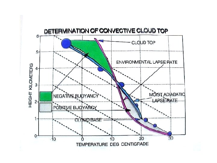
Fair weather cumulus cloud development • Buoyant thermals due to surface heating • They cool at dry adiabatic lapse rate (conserve ) • Cloud forms when T = Td (RH ~ 100%) • Sinking air between cloud elements • Rising is strongly suppressed at base of subsidence inversion produced from sinking motion associated with high pressure system
Fair weather cumulus cloud development schematic
What conditions support taller cumulus development ? • A less stable atmospheric (steeper lapse rate) profile permits greater vertical motion • Lots of low-level moisture permits latent heating to warm parcel, accelerating it upward
Precipitation Formation How can precipitation form from tiny cloud drops? 1. Warm rain process 2. The Bergeron (ice crystal) process 3. Ice multiplication How many 20 µm cloud drops does it take to make a 2000 µm rain drop? V = 4/3 pr 3 = pd 3/6 (2000/20) 3 = 1, 000
• In a supersaturated environment, activated cloud drops grow by water vapor condensation – It takes many hours for the cloud drop to approach rain drop size • Collisions between cloud drops can produce large rain drops much faster through coalescence – Collisions occur in part due to different settling rates of large and small drops – Not all collisions result in coalescence • Rain formation favored by – Wide range of drop sizes – Thick cloud – Fast updrafts Rain formation in warm clouds (no ice)
Rain formation in warm clouds • Capture of a cloud/rain drop in a cloud updraft can give it more time to grow • The drop falls at a fixed speed relative to the air, not the ground • Large drops fall faster
Ice crystal growth by vapor deposition (Bergeron process) • Ice binds water molecules more tightly than liquid water – For temperatures less than 0ºC, the saturation vapor pressure over ice is less than the saturation vapor pressure over supercooled water • This leads to evaporation of water from supercooled cloud drops and deposition onto ice crystals
Ice crystal growth by accretion • Ice crystals fall faster than cloud drops • Crystal/drop collisions allow ice crystals to capture cloud drops – The supercooled drops freeze upon contact with the ice crystal – This process is known as accretion or riming • Extreme crystal riming leads to the formation of – Graupel – Hail
Ice Crystal Processes in Cold Clouds • Outside deepest tropics most precipitation is formed via ice crystal growth • Supercooled cloud drops and ice crystals coexist for – 40º < T < 0º C – Lack of freezing nuclei to “glaciate” drops • Ice crystals can grow by – Water vapor deposition – Capture of cloud drops (accretion/riming) – Aggregation
Precipitation in cold clouds • Low liquid water content promotes diffusion/deposition growth of large crystals • High liquid water content promotes riming and formation of graupel/hail • If the sub-cloud layer is warm, snow or graupel may melt into raindrops before reaching the surface (typical process for summer rain in Colorado)
Hail • Hail can form in clouds with – High supercooled liquid water content – Very strong updrafts decoupled from downdrafts • Hailstones typically make 2 -3 trips up through cloud • Opaque and clear ice layers form – Opaque represents rapid freezing of accreted drops – Clear represents slower freezing during higher water accretion rates – Layering tells about hailstone history The largest hailstone ever recovered in the United States, a seven -inch (17. 8 centimeter) wide chunk of ice almost as large as a soccer ball. It was found in Aurora, Nebraska on June 22, 2003. The hailstone lost nearly half of its mass upon landing on the rain gutter of a house
Lifecycle of a Simple Thunderstorm • Updraft • Glaciation • Rain shaft • Anvil • Collapse • Cirrus “debris”
stratosphere very dry overshooting top vapor + ice liquid + vapor + ice free troposphere anvil dry air entrainment moist updrafts liquid + vapor boundary layer water vapor
Organized Squall Line • Decoupling of updraft and downdraft due to “shear” (vertical change in horizontal wind) • Propagation by initiation of new convective cells along gust front at leading edge of cold pool
Squall Line Structure Sequence at surface: (1) strong wind gust under rainfree cloud; (2) heavy rain; (3) tailing off to light rain
Squall Line 5 June 2008
Supercell Thunderstorms
Supercell Thunderstorms • Highly-organized single-cell storms persisting for hours, responsible for nearly all tornados and damaging hail • Conditions: – Very unstable, moist environment – Winds turn clockwise with height (e. g. , from south at surface, from west aloft) • Characteristics: – Storm-scale rotation – Huge updrafts to 100 mph – Wall clouds, tornados, violent downdrafts and surface gusts
Tornados • Small but intense surface vortices produced by supercell storms • Surface winds can be > 250 mph • Average of 1000 reported per year in USA, with 80 killed and 1500 injured
How Tornados Form: pre-existing vorticity is tilted and then stretched in a supercell thunderstorm updraft Surface friction produces “roll vortices” Vortex is entrained into updraft and tilted into vertical Vortex tube is stretched in rotating updraft and intensifies
US Tornado Occurrence • Roughly 1000 tornados each year in US • Many more in US than anywhere else in the world! • Trends in reporting, but probably not trends in actual occurrence
“Tornado Alley”