EROSION The transport of weathered materials Major Erosive


")


 n Suspension: particles")


- Slides: 70
EROSION- The transport of weathered materials…
Major Erosive Agents: n Running Water n GLACIERS n WIND n OCEAN CURRENTS AND WAVES n MASS WASTING (GRAVITY!)
EROSION by gravity n Also known as MASS MOVEMENT n. Avalanches or rock falls n. Land or Mud Slides n. Slump or Flows n. Creep
1995 Landslide in La Conchita, CA.
The two forces involved in all mass movements are GRAVITY (pulling the material down) and FRICTION (keeping the material in place). Typically excessive amounts of water lessen the force of friction and lead to a landslide.
New York City’s Henry Hudson Parkway in Upper Manhattan A 75 foot retaining wall collapsed on May 12 th, 2005.
Running water move more sediment than any other agent of erosion.
What happens to rainfall when it hits earth? ? n Some evaporates n Some is absorbed and becomes ground water n Some is run off
What determines if rainwater becomes runoff or groundwater? Ground Conditions: n Saturated vs. unsaturated n Vegetation – amount of plants n Slope or Gradient of the Land
Running Water – Most of North America is above sea level. Water flows high to low sea level due to gravity
When Runoff becomes confined to a channel – Stream Exists
Watersheds or Drainage Basins n Smaller stream that flows into a larger stream is called a tributary n Tributaries and land that contribute to the stream is called a drainage basin or watershed (COMPARED TO A BATHTUB. WATER THAT COLLECTS IN A BATHTUB FLOWS TOWARD THE DRAIN. ) n The drainage basin of one stream is separated by a drainage divide (ridges or mountains – higher elevations)
HOW WATERSHEDS/DRAINAGE BASINS FORM – RED LINE IS DRAINAGE DIVIDE
Watersheds: Continental Divide and Appalachian Mountains Water goes from high sea level to low sea level
Watershed Regions of New York State
3 factors affecting Stream Velocity q Gradient – slope of the stream q Discharge – volume of water q Stream channel shape
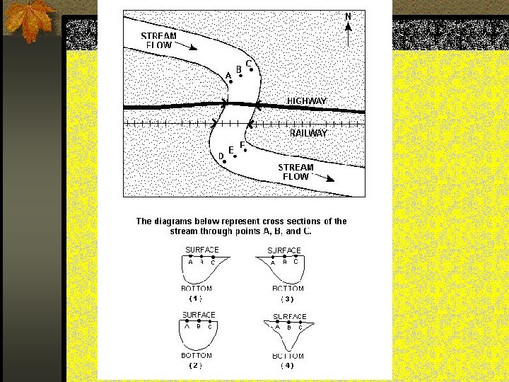
Stream Velocity in a Straight Channel Fastest – middle just below surface
The velocity changes in the S-shaped curves called MEANDERS. Fastest on the outside of the curve – erosion Slowest on the inside of the curve - deposition
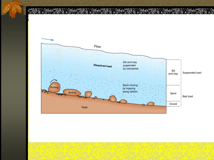
STREAMS CARRY MATERIAL IN … n Solution: dissolved material (includes salts) n Suspension: particles carried in the flow of the water (Clay, silt, sand) n Bed load: particles carried by rolling, bouncing, or dragging along the stream bed (Pebbles, cobbles, boulders)
THE GREATER THE VELOCITY OF A STREAM… § THE LARGER THE SEDIMENT PARTICLES IT CAN CARRY § THE MORE TOTAL SEDIMENTS IT CAN CARRY
Water Velocity determines the size particle that can be moved via suspension and bed load
Stream Development – Early Stage n The landscape is continuously being reshaped by stream erosion. Plateaus can be cut by rivers to form canyons. Valleys can be carved in mountains as rivers flow through them. n As the stream begins to down cut into the land – waterfalls and rapids form
Stream Development – Young Stage n V-Shaped Valley n Rapids and Waterfalls n No Flood Plain – a level plain that borders stream
V-SHAPED VALLEY…
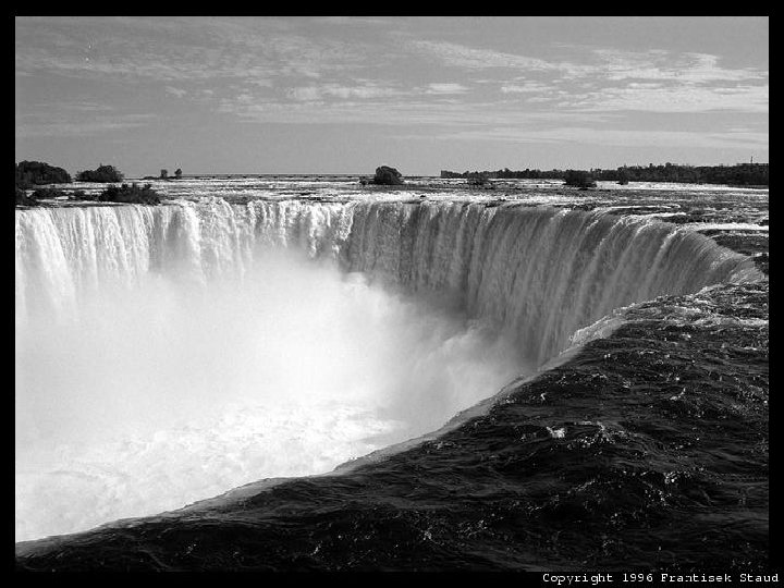
RAPIDS AND WATERFALLS n Rapids - Different resistance among rocks cause FAST-FLOWING WATER n Waterfalls – Rapids develop into waterfalls as softer rock erodes
Stream Development - Mature Stage n Lateral erosion widens the valley profile – slope decreases n River meanders pronounced n A FLOOD PLAIN develops
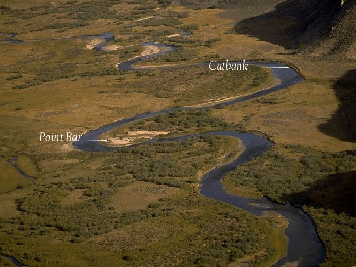
As the stream grows larger – it begins to shift its course in a series of bends or curves called meanders seeking out the lowest elevation
Point Bars show deposition Cut Banks show erosion
Cut bank on outside of curve due to higher velocity of water – more erosion Cut bank on outside of curve Point Bar on inside of curve
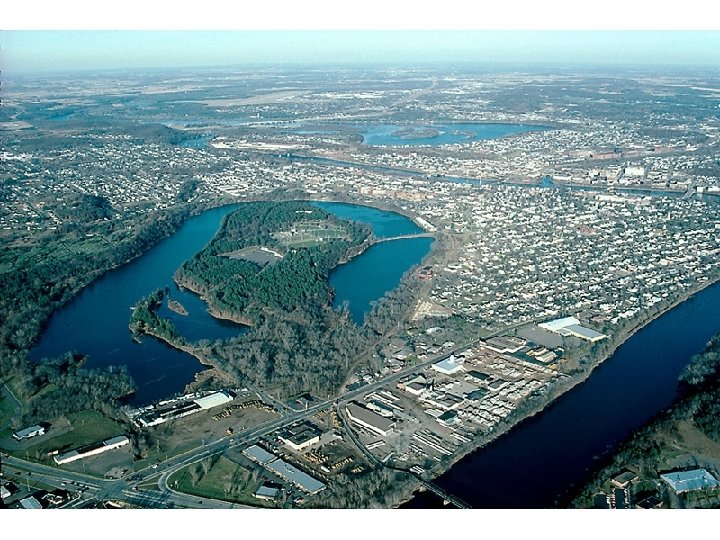
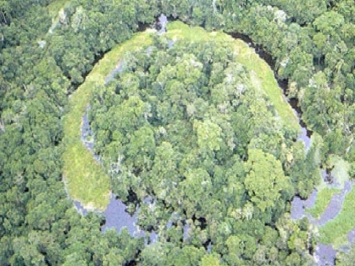
Stream Development - Old Age n Very Wide Flood Plain n Land worn down to flat surface n Oxbow Lakes
Stream Development – Old Age
Eventually, it takes too much energy to keep meandering, so rivers will cut off a bend, resulting in an OXBOW lake…
What is the correct sequence in stream development?
Levee Formation
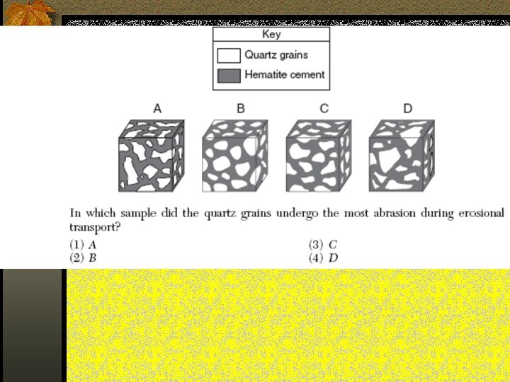
SEDIMENTS ERODED BY RUNNING WATER WILL HAVE THESE CHARACTERISTICS n ROUNDED and SMOOTH n SORTED AND LAYERED
SEDIMENTS ERODED BY RUNNING WATER WILL BE … n SORTED – all materials are about the same size
Contour lines showing head of the stream to the mouth of stream with delta Velocity slows when entering a large body of water
Alluvial fans form when streams come out of mountains onto flat land – velocity slows and deposition occurs
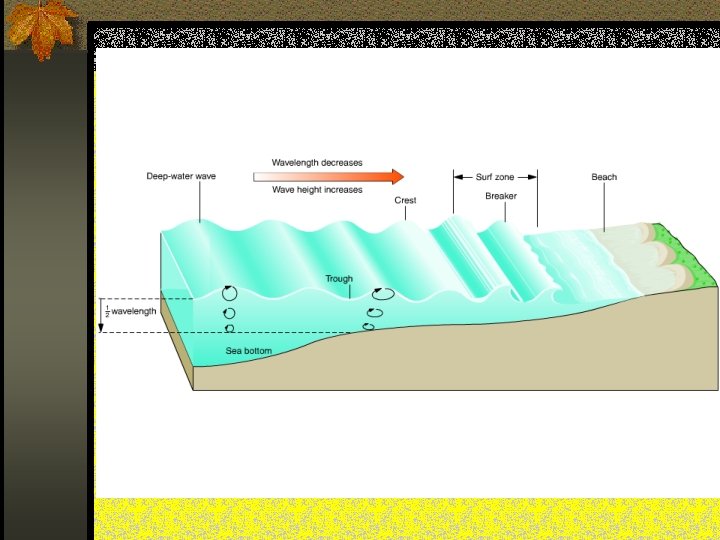
Erosion by Waves and Long shore Current n Where lake or ocean waters meet land, waves and currents act as agents of erosion, creating unique landscape features
Winds at the ocean’s surface cause waves
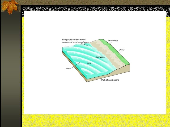
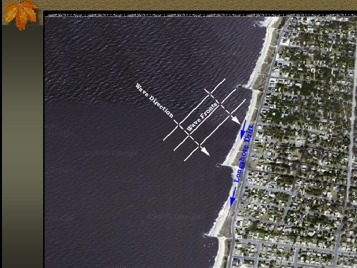
Longshore Current n Waves are refracted or bent in the shallow water of the shore n Water near the shore is pushed in one direction along the shore – called longshore current Sediments are carried in a zig-zag pattern in the SAME direction as the longshore current
The sand trapping effect of the jetties to the north at Charleston, South Carolina has deprived Morris Island of needed sand. As a result, the island has eroded to the point that this previously land based lighthouse is now 400 meters out to sea.
Which direction is the long shore current carrying sediment? ?
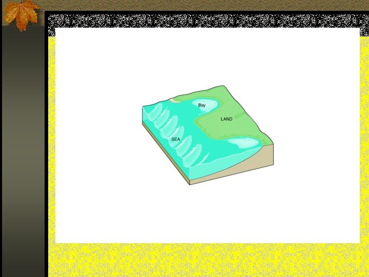
Barrier Islands n Wave Action creates sand bars n Waves and Longshore current - can form barrier islands Ex. Fire Island
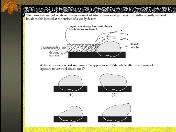
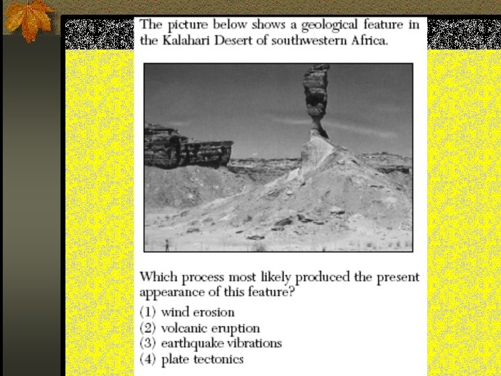
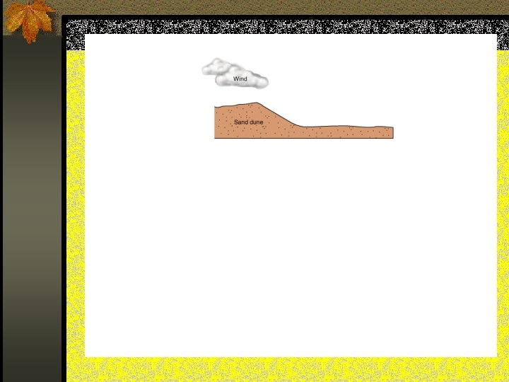
Wind Erosion n Sediment – sand or smaller n Arid regions or ocean coastlines n 2 types: 1. Deflation – lowers the land 2. Sandblasting and Abrasion
Sandblasting and Abrasion n Wind can only lift sand to about 1 meter high - results in “Mushroom Rock” n Frosted or Pitted sediments – rocks with flat sides
Windward side Leeward side