Revegetation of Reconstructed Reaches of the Provo River

 WHAT u WHY u WHERE u HOW u")


 Required mitigation for past impacts to riverine,")


")

 Honeysuckle Lonicera utahensis Serviceberry Amelanchier alnifolia Pacific willow Salix")


- Slides: 72
Revegetation of Reconstructed Reaches of the Provo River, Heber Valley, Utah Presented by John A. Rice, Utah Reclamation Mitigation and Conservation Commission
Provo River Restoration Project (PRRP) WHAT u WHY u WHERE u HOW u
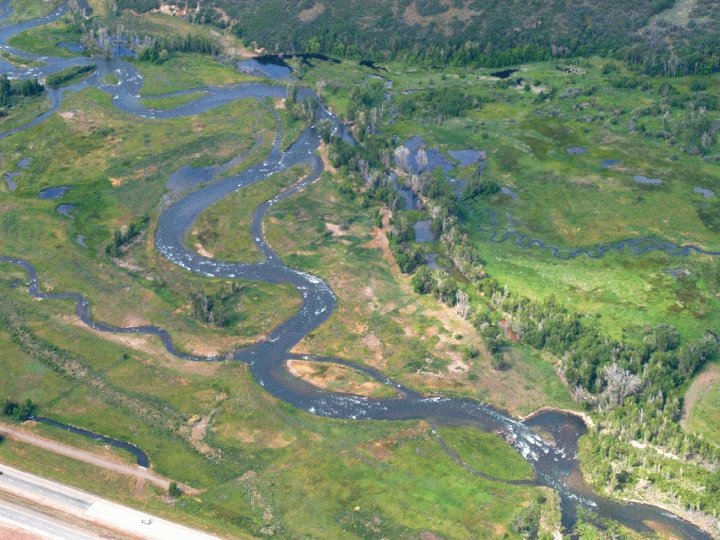
WHAT u. A project to create a more naturally functioning riverine ecosystem between Jordanelle Dam and Deer Creek Reservoir by: – Removing most dikes – Recreating river meanders and river channel features – Establishing an active floodplain with riparian, wetland stream habitats – Restoring ecosystem functions
WHY – Increase biological productivity and diversity – Restore and improve fish and riparian habitats – Provide public (angling) access to the river corridor
The Central Utah Project Completion Act (CUPCA) Required mitigation for past impacts to riverine, wetland, & riparian habitats caused by the CUP & other Federal Reclamation projects
WHERE IS PRRP? Provo River Basin
Provo River Watershed Transbasin Augmentations Weber/Provo Canal Jordanelle Duchesne Tunnel Deer Creek Utah Lake
WHY the Provo River? • After transbasin augmentations were introduced, flooding became a major problem • As a result of this flooding, the Provo was channelized and diked in the 1950 s and 1960 s
Jordanelle Dam, Bonneville Unit of the CUP • affords flood control once provided only by dikes along the river • provides minimum flows of 125 cfs Courtesy of USBR
HOW? u In cooperation with Local, State and Federal resource management agencies u With involvement from both the private and academic sectors u Lots of public involvement
November, 1999
Reach 7 Design
Revegetation u Scope u Lessons Applied – Lessons Learned
Area Disturbed Each Year 1998 - 18 acres 1999 - 27 acres 2000 - 34 acres 2001 - 76 acres 2002 - 16 acres 2004 - 67 acres 2005 - 66 acres (planned)
Total Number of Plants Installed 1999 2000 2001 2002 2003 2004 2005 Total 22693 55543 68663 56734 29645 89616 65038 387931
Lessons Applied u. Adaptive Management – Plan; Study; Construct; Monitor; Repeat
ADAPTIVE MANAGEMENT u Plan Ahead – Way Ahead – Pre-Restoration Studies – Topsoil Harvesting and Stockpiling – Haul Routes – Excess Material Disposal – Post-Construction Access
Pre-Restoration Studies Sediment Transport u Depth, Velocity, Substrate, Channel Form u Macroinvertebrates u Fish – Native and Sport u Wildlife – Spotted Frog, Birds, Mammals u Plant Communities – Species Composition, Hydrology, Erosion, Weeds u
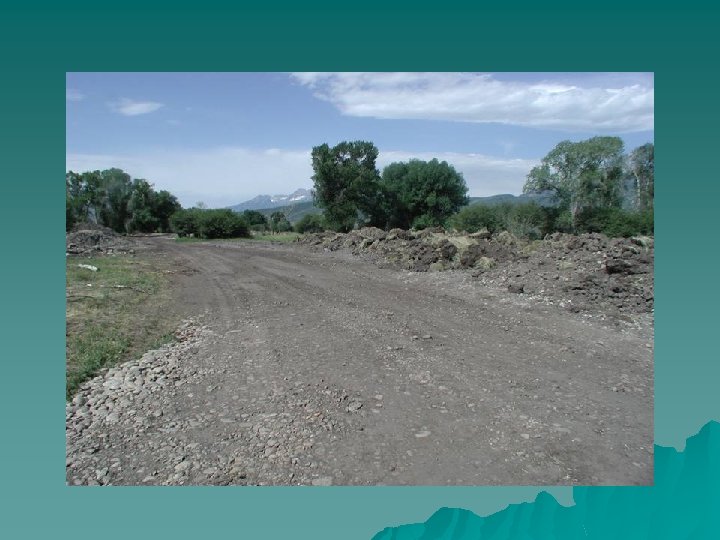
Topsoil Harvesting and Stockpiling u u Top-soil should be stripped from all areas to a depth of 18 inches or a depth where significant (greater than 50%) rock, stone, cobble, etc are encountered, whichever comes first. Sub-soil with less than 40% rock, stone, cobble, etc. should be stockpiled separately. Sub-soil with more than 40% rock, stone, cobble, etc. should be stockpiled separately, used to construct features or spoiled. The top 12 inches of soil from areas where weeds are common should be stripped and spoiled (bury it deep!).
Topsoil Placement u Top-soil and suitable sub-soil should be used, to the maximum extent possible (no less than 1 foot of top-soil over subsoil). u Top-soil/sub-soil should be placed following all construction and final grading, and just before planting, to avoid any activity that would result in compaction or which would require re-working the site. u Top-soil and sub-soil should be transported/dumped in suitable locations/piles so that it can be spread with a backhoe bucket and not driven on (even by the backhoe) or compacted in any way.
Avoid Compaction!!!! u Compaction severely inhibits root growth and water percolation. To the maximum extent possible, activities that would result in compaction should be avoided. u It should be noted that working soils when they are at or near field capacity (wet) often results in significant compaction.
Haul Routes u Haul routes should be minimized, and, to the maximum extent practicable, should not cross wetlands, wet areas, or constructed features. u If crossing a constructed feature becomes necessary, compacted areas should be "ripped" prior to topsoiling. u No crossing should occur on topsoiled areas.
Excess Material u u u Onsite disposal can cause site impacts by disturbing additional area and possibly covering productive habitat with the excess material. Onsite disposal can create a new source of sediment and may cause water quality degradation if the excess material is not protected from drainage and runoff. However, careful dispersal of excess material on-site will not only avoid transportation costs, but can reclaim disturbed habitats.
Disposal in Old Channel
Construct Features
Lessons Applied u. Riparian Succession – Natural Disturbance Regime – Clementsian Succession
Dynamics
Natural Disturbance Regime
September 2004
Riparian Succession u Clementsian Succession – Ordered Sequence of Plant Associations Culminating in a “Climax” Community – Avoid the Early Stages or Interrupt the Sequence by Seeding and Installing Plants Associated with Later Stages of Succession – Most Applicable Away from the River Channel
Lessons Applied u. Choose the Right Plants for the Site – Native Species Found Within the Corridor – Plants are installed in appropriate locations
Upland Seed Blend COMMON NAME u Bluebunch wheatgrass u Western wheatgrass u Squirreltail u Great Basin wildrye u Mountain brome u Lewis flax u Yarrow SCIENTIFIC NAME Pseudoroegneria spicata (Agropyron spicatum) Pascopyrum smithii (Agropyron smithii) Elymus elymoides Elymus cinereus Bromus marginatus Linum perenne lewisii Achillea millefolium
Wet Meadow Seed Blend COMMON NAME SCIENTIFIC NAME u Beaked sedge Carex rostrata u Nebraska sedge Carex nebrascensis u Baltic rush Juncus balticus u Water sedge Carex aquatilis
Riparian Seed Blend COMMON NAME u Western wheatgrass Squirreltail u Great Basin wildrye u Mountain brome u Blue wildrye u Slender wheatgrass u SCIENTIFIC NAME Pascopyrum smithii (Agropyron smithii) Elymus elymoides Elymus cinereus Bromus marginatus Elymus glaucus Elymus trachycaulus
Broadcast Seed (40 lbs/ac)
Shrub and Tree Species Used in PRRP Revegetation Alder Alnus incana Birch Betula occidentalis Boxelder Acer negundo Chokecherry Prunus virginiana Cottonwood Populus angustifolia Dogwood Cornus stolonifera Golden Currant Ribies aureum Hawthorne Crataegus douglasii
Shrub and Tree Species (cont’d) Honeysuckle Lonicera utahensis Serviceberry Amelanchier alnifolia Pacific willow Salix lasiandra Coyote willow Salix exigua Yellow willow Salix lutea Wood's Rose Rosa woodsii
Trees and Shrubs Installed as Rooted Stock
Plant Material Collection Sites u To maintain the genetic integrity of the local plant community, plant materials should be collected within a 100 mile radius of Heber Valley (Wasatch County, UT), and from an area with an elevation ranging between 4800 and 6500 feet above mean sea level.
Plant Installation Sites u Plants are installed in groupings that mimic natural associations and at sites that are appropriate from a water and sunlight perspective. Topsoil is fairly uniform, so soil type is not a consideration.
Lessons Applied u. Plant Size – Bare-Root Matters u. Cottonwood, Willow, Wood’s Rose, Dogwood, Boxelder – Quart Sized Containers u. Chokecherry, Golden Currant, Alder, Birch
Lessons Applied u. Plant Dense –Planting density and floral composition of shrubs and trees are based on the results of a study conducted by the University of Arizona (Stromberg et. al. 1999)
–In 1999 and 2000, we installed 1700 shrubs/ac and 400 trees/ac in wetland/riparian areas. –Because survival was higher than expected (75% vs 50%), in subsequent years we installed 1200 shrubs/ac and 300 trees/ac.
Plants Installed
Lessons Learned u Coordinate Installation with Plant Availability and Site Availability u Irrigation
July 2001
September 2001
August 2002
July 2003
July 2005
May 2000
September 2000
August 2001
August 2002
June 2005
September 2000
August 2001
August 2002
April 2005
June 2005
July 2001
September 2001
August 2002
August 1999
October 1999
May 2000
September 2001
July 2004
June 2005
Thank You