WEATHER AND CLIMATE Weather the daytoday properties such


 Occurs in the Tropical Pacific Ocean Natural climate")
 • The reverse of El Nino • Surface water of the")

 Average annual temperature 2) Average")

 Rainforest Temperate forest Grassland Desert Taiga (Boreal forest;")


 • Tiaga (Boreal/Coniferous Forest) • • Cold temps Low amount")
 • Chaparral • • Frequent fires Drought High temps Low")

 • Taiga • Needle-like leaves (drought resistant) • Sloped")
 • Chaparral – • • • Extensive, shallow root")

 • Taiga – • Hibernate • Migrate • Store")
 • Chaparral – animals are grassland/desert type • Nocturnal")


 2. Magnuson Fishery")


- Slides: 72
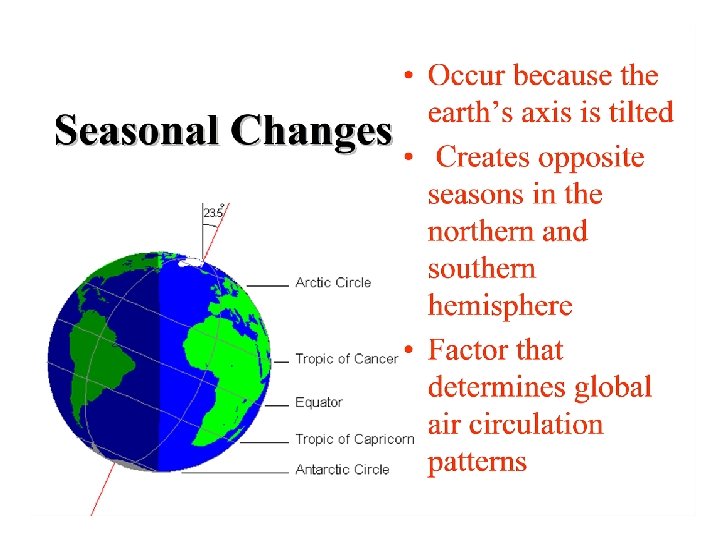
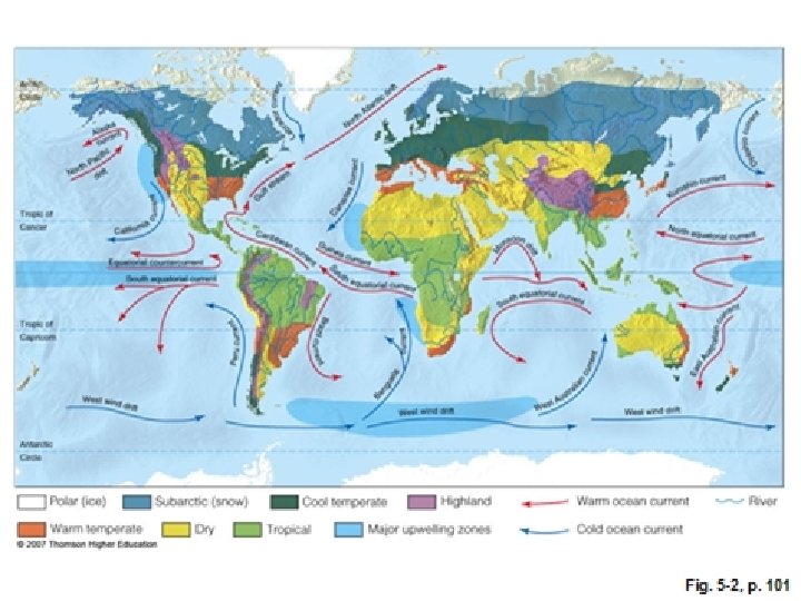
WEATHER AND CLIMATE Weather – the day-to-day properties such as wind speed and directions, temperature, amount of sunlight, atmospheric pressure and humidity. Climate is determined by two main factors: 1) average annual temperature 2) average annual precipitation
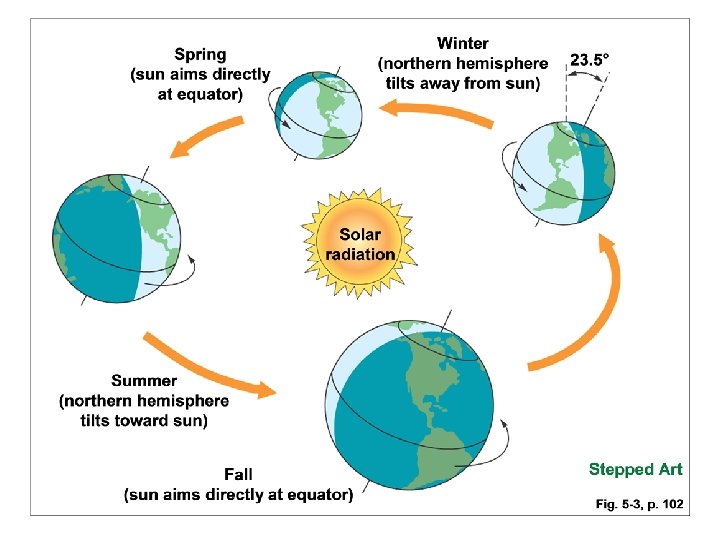
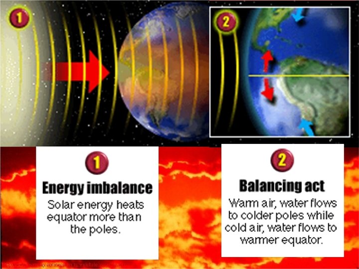
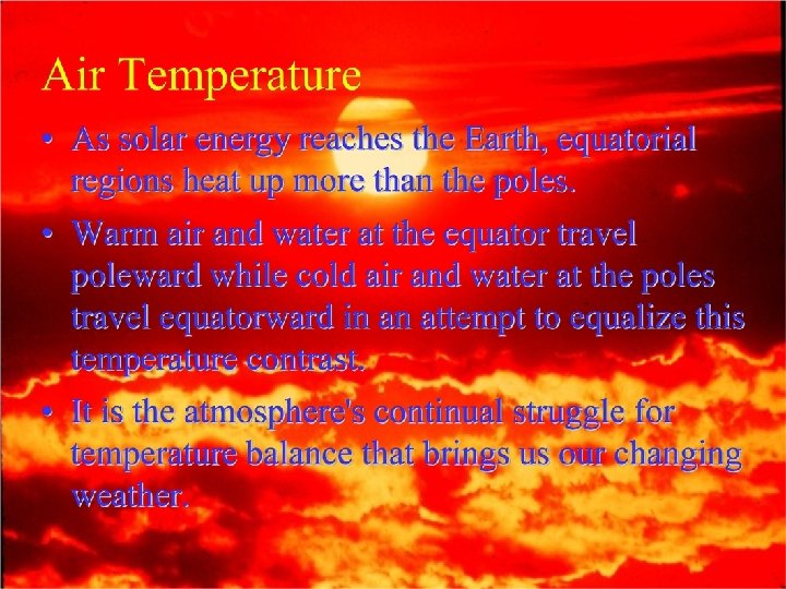
WEATHER AND CLIMATE The weather and climate of any given area is the result of the Sun unequally warming the Earth and the rotation of the Earth. The latitude which receives the most direct sunlight throughout the year is 0° …. The equator.
Global Air Flow Patterns The motion of air around the globe is the result of solar heating, the rotation of Earth, and the physical properties of air, water and land. • There are 3 major reasons that Earth is unevenly heated: 1) More of the Sun’s rays strike the Earth at the equator than strike the poles. 2) The tilt of Earth’s axis points regions toward or away from the Sun. 3) Earth’s surface at the equator is moving faster than the poles (aka Coriolis Effect). This causes the motion of the air to curve forming major prevailing winds.
Convection currents are the vertical movement of air due to atmospheric heating and cooling. Warm, moist air rises (less dense). The higher altitude has less pressure and is colder, causing the air to cool and expand. This process is known as adiabatic cooling. As the air cools, it is unable to hold much moisture, and precipitation occurs. Adiabatic warming occurs as the now cool air descends (more dense) and becomes subject to the lower atmosphere’s higher pressure.
Say That Again…. . • As air near the Earth’s surface warms, all of the following occur – Air rises – Air expands – Adiabatic cooling occurs – Water vapor condenses causing precipitation
Hadley Cells create major weather pattern due to adiabatic cooling and adiabatic warming. A large Hadley cell starts its cycle over the equator where warm air evaporates and rises; cools and drops rain. This process accounts for the abundant tropical rainforests. The cool dry air then descends about 30° north and 30° south of the equator, forming deserts at these latitudes.
Rain Shadow Effect • The rain shadow effect allows the same process to occur more locally. • Occurs when moisture-rich air encounters a mountain range and is deflected up the mountain range. As the air moves up, it cools and water precipitates out on the windward side of the mountain. By the time the air mass reaches the opposite side of the mountain, it is virtually devoid of moisture, causing an arid climate on the leeward side of the mountain.
Rain shadow effect Windward side – receives rain • Responsible for impressive forests – Olympic rainforest on Washington state’s coast (receives 5 m of rain per year) Leeward side – extremely dry • Causes the severest deserts in the world – Death Valley in eastern California
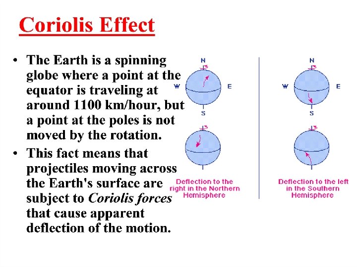
Coriolis Effect • The deflection of an object above the Earth including wind currents. – Southern Hemisphere • Left • East • clockwise – Northern Hemisphere • right • west • Counterclockwise
The Coriolis Effect determines the direction of major Wind Patterns 1. Trade winds • between 30° N and equator; 30°S and equator • Named for the ability to propel trading ships across the ocean • Move counterclockwise (right) in Northern hemisphere; clockwise (left) in Southern hemisphere 2. Westerlies • Between 30° N and 60° N; 30° S and 60° S • Travel south and west in Northern hemisphere; north to west in Southern hemisphere 3. Polar easterlies • Between 60° N and North Pole; blow north to east • Between 60° S and South Pole; blow south to east
Prevailing Wind Patterns
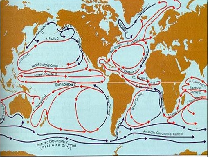
Ocean Currents • The ocean currents mirror the movements of the atmosphere flowing clockwise in the Northern hemisphere and counterclockwise in the Southern hemisphere. • Warm equatorial waters flow (set in motion by prevailing winds and the rotation of the Earth) to the poles and cold polar water flows toward the equator setting up circular patterns known as gyres. • This massive movement of ocean water plays an important role in determining the Earth’s climate.
Global Heat Engine The major role of the gyres is to redistribute heat from the equator to the Northern latitudes thus regulating Earth’s climate.
El Nino and Southern Oscillation (ENSO) Occurs in the Tropical Pacific Ocean Natural climate variation Causes fish populations to decline The trade winds weaken, allowing warm water to move eastward • Upwelling is suppressed off the coast of South America • • – Upwelling – area of cool, high-nutrient waters along a coast.
La Nina (ENSO) • The reverse of El Nino • Surface water of the ocean surrounding Central and South America are colder than normal • Fish populations and fishing industry thrive due to prominent upwelling • ENSO (El Nino and Southern Oscillation) – the alteration of atmospheric conditions that lead to El Ninos and La Ninas
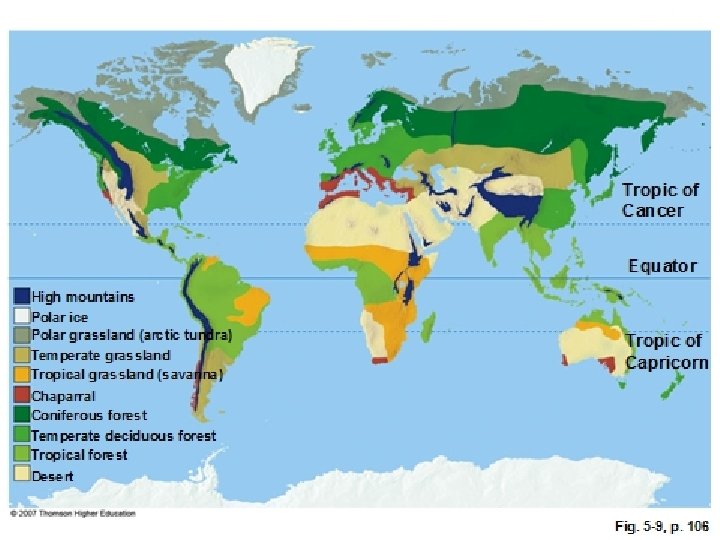
Terrestrial biomes • Classified based on 3 factors 1) Average annual temperature 2) Average annual precipitation 3) Distinctive plants adapted to the area - climax vegetation
Classification by Name More Narrow (7) Rainforest Temperate forest Grassland Desert Taiga (Boreal forest; Coniferous forest) • Tundra • Chaparral • • • Broad (4) • Mountains • Forests • Grasslands • Deserts
Latitude and Altitude also determine biome characteristics
Deserts …. . At different latitudes
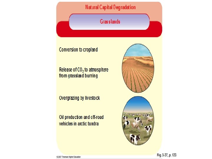
Grasslands • • Grassland Savanna Pampas Prairie Tundra Steppes Velds Plains
Limiting Factors • Temperate forests • Space • Seasonal variations • Tropical Rainforest • Space • Nutrient-poor soil • Grasslands • Frequent fires • Strong winds • Low amount of precipitation (too dry to support trees)
Limiting Factors (cont. ) • Tiaga (Boreal/Coniferous Forest) • • Cold temps Low amount of precipitation Decomposition rate very slow Acidic; nutrient-poor soil • Tundra • • • Cold temps Low amounts of precipitation Decomposition rate very slow Short growing season Few plants High winds
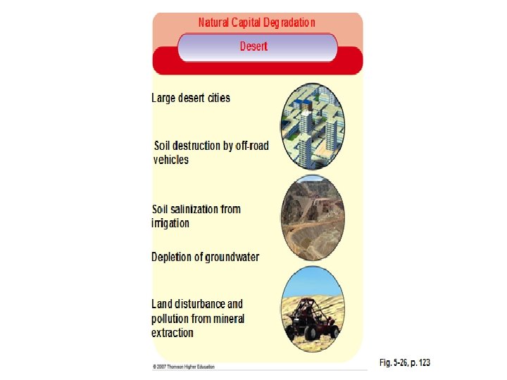
Limiting Factors (cont. ) • Chaparral • • Frequent fires Drought High temps Low precipitation • Desert • • High temps Very low precipitation Brief sporadic growing season Few plants
Adaptations - Plants • Temperate forest • Drop leaves in the fall • Shade-tolerant due to vertical stratification • Tropical rainforest • • Shade-tolerant Shallow roots Enlarged roots (buttresses) Take in water and minerals directly from rain • Grasslands • Extensive root systems ( several meters underground) • Underground stems (to survive fires)
Adaptations – Plants (cont. ) • Taiga • Needle-like leaves (drought resistant) • Sloped branches (for snow to slide from) • Tundra • Shallow roots • Small and short
Adaptations – Plants (cont. ) • Chaparral – • • • Extensive, shallow root system Small, hard leaves Allelopathic Dormant during dry season Fire-resistant roots • Desert – • • • Extensive root systems Store water (succelents) Modified leaves (spines, thick cuticles) Remain dormant for long periods of time (30 years) Germinate very quickly
Adaptations - Animals • Temperate forest – • Hibernate • Migrate • Tropical rainforest – • Live in trees • Grassland – • Live underground • Migrate
Adaptations – Animals (cont. ) • Taiga – • Hibernate • Migrate • Store body fat • Tundra – • Heavy fur coats • White coats blend in with snow • Specialized hooves, feet
Adaptations – Animals (cont. ) • Chaparral – animals are grassland/desert type • Nocturnal • Oversized ears • Water-tight skin • Desert – • • Nocturnal; active in early morning Burrow underground Oversized ears Pant or sweat Water-tight skin Get water from food they eat Excrete highly concentrated urine
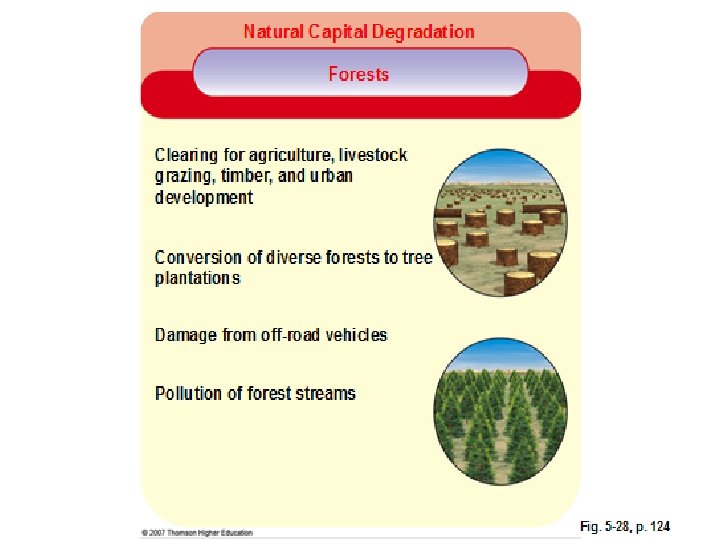
Forest Biomes • 30% of the land area of the world is forest. • Forests provide the following ecological services: – Conservation of biodiversity – Moderation of climate – Prevention of erosion – Storage of carbon and nutrients – Replenishing oxygen
Consequences of Deforestation • One of the greatest threats to these biomes is deforestation due to the conversion of forests into pastures or agricultural fields. – Reduces biodiversity – Reduces nutrient availability – Increases erosion – Increases runoff and flooding – Reduces the amount of CO 2 removed from atmosphere
5 Forest Management Methods 1. Clear-cutting – removing all trees in an area at one time; leaves barren landscape. 2. Selective cutting – removing only certain trees; maintains high biodiversity. 3. Shelter-wood cutting – removing mature trees in groups over many years and leaving many trees to reseed the area. 4. Seed-tree cutting – removing all small trees and leaving the large, mature, seed-bearing trees. 5. Tree farms (plantations) – tracts of trees of the same age that are planted and managed and harvested for commercial use; little diversity.
Other Important Vocabulary • Microclimate – small areas within a biome/ecosystem that may have different conditions than the biome itself. – Caves, valleys, large forests, even cities • Ecotone – a transitional area between two biomes that has characteristics of both. • Mitigation banking – creating or restoring as much wetlands as are destroyed.
Transition Zones
Transition Zones • Estuaries – areas where the mouth of a river meets the sea; have high concentrations of nutrients and sediments; rich in biodiversity. – Chesapeake Bay, MD • Mangrove swamps – coastal wetlands found in tropical and subtropical regions. • Barrier islands – created by the buildup of deposited sediments just off the coastal shores; act as buffers against storms. Erosion during strong storms may erode islands completely; prime land for tourism. – Outer Banks, NC
Mangrove Swamps • • Mangroves are salttolerant trees. Trees protect the coast from erosion and shield inland area from severe damage during hurricanes and tidal waves. Traps sediment washed off the land. Act as “sponges” for pollutants. High in nutrients and biodiversity. Serves as sanctuary and nursery for numerous aquatic species. Being cut down for wood, shrimp farming and coastal land development.
AQUATIC LIFE ZONES
Freshwater Life Zones
Freshwater Life Zones • Littoral zone – begins with very shallow water at the shoreline, ends at depth at which rooted plants stop growing; receives abundant sunlight; nutrient-rich. • Limnetic zone – surface of the open water area, extends to the depth that sunlight can penetrate. • Profundal zone – water that is too deep for sunlight to penetrate; cool and dark; also known as aphotic zone. • Benthic zone – deepest layer in a body of water; characterized by very low temperatures and low oxygen levels. Decomposers are abundant.
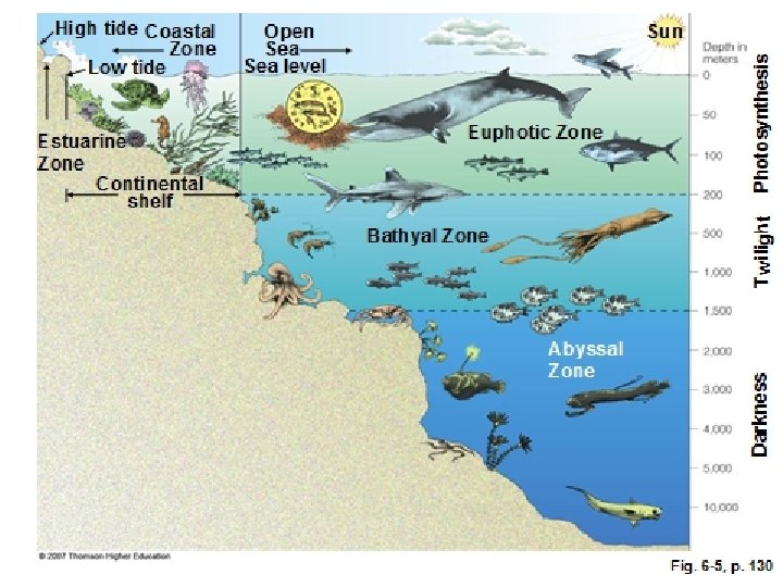
The World’s Oceans are divided into zones based on changes in light and temperature and cover about 70% of the earth’s surface.
Ocean Zones • Coastal zone – consists of area between the shore and the end of the continental shelf. Coral reefs are included in this zone; has world’s highest NPP per unit area. • Euphotic zone – includes the upper layers of water which receive enough sunlight for photosynthesis to occur; is the warmest region of the ocean and has the highest levels of dissolved oxygen. • Bathyal zone – steep descent of the seabed from the continental shelf to the abyss; the middle region. Receives insufficient light for photosynthesis and is much cooler. • Abyssal zone – deepest region of the ocean; hydrothermal vents located here.
Coral Reefs • One of the most diverse ecosystems in the world. • Corals are animals that have algae living in their tissues (zooxanthellae) that allows them to photosynthesize. • Require water that is clear, warm and shallow enough for photosynthesis. • Corals are extremely delicate and very vulnerable to physical stresses, changes in light intensity and water temperature. • Coral bleaching – when corals lose their algae and turn white; due to increased water temps (El Nino, global warming). • Sediments from construction and agricultural practices are also detrimental. • Other threats include ecotourism, collectors, exotic pet trade, and the use of dynamite or cyanide to stun fish.
The Abyss • Zone marked by extremely cold temperatures and very low dissolved oxygen levels. • High levels of nutrients because of the decaying plant and animal matter that sinks down from the zones above. • Decomposers are mainly bacteria. • Organisms in this zone often rely on chemosynthesis to survive.
Hydrothermal Vents
Primary Productivity
Human Impact • Worldwide, about one billion people depend on fish as their main source of food, and about one million people are currently employed in the fishing industry. • About 125 million tons of fish are harvested each year.
Fishing Methods • Bottom trawling – technique in which the ocean floor is literally scraped by heavy nets that smash everything in their path. Some bans have been placed on this practice. • Driftnets – nets that are dragged through the water and indiscriminately catch everything in their path. • Long lining – use of long lines that have baited hooks; taken by numerous aquatic organisms. • By-catch – term for any other species of fish, mammals, or birds which are caught and are not the target species. – Dolphins in tuna nets
Fish farming in cage Trawl flap Trawler fishing Spotter airplane Sonar Purse-seine fishing Trawl lines Fish school Trawl bag Long line fishing Drift-net fishing Float Buoy Lines with hooks Deep sea aquaculture cage Fish caught by gills Fig. 12 -A, p. 255
Tragedy in the Commons • Occurs when a resource utilized by many people (the public) is exploited and eventually depleted. • Many marine fisheries are being overfished. According to the U. N. ’s Food and Agricultural Organization (FAO), – 52% of fish stocks are fully exploited – 16% are over-exploited – 8% are depleted
Solutions to the Tragedy • Private ownership – The assumption is that if you own the resource, you will take better care of it. • Regulation – Establish laws that prevent tragedy from occurring. For example, put limits on how many fish can be caught per company per season.
US Laws Name of Legislation 1. Anadromous Fish Conservation Act (1965) 2. Magnuson Fishery Conservation and Management Act (1976) 3. Marine Mammal Protection Act (1972) 4. Endangered Species Act (1973) 1. 2. 3. 4. What it Does Protects fish that live in the sea but grow up and breed in freshwater (salmon) Governs the conservation and management of ocean fishing Established a federal responsibility to conserve marine mammals (manatee) Provides broad protection for species of fish, wildlife, and plants that are listed as threatened in the US or elsewhere
International Treaties Name of Legislation 1. The United Nations Agreement for the Implementation of the Provisions of the United Nations Convention of the Law of the Sea (1982) 2. CITES (1975) The Convention on International Trade in Endangered Species of Wild Fauna and Flora What it Does 1. Sets out the principles for the conservation and management of certain types of fish 2. An international agreement between governments that ensure that international trade in specimens of wild animals and plants do not threaten their survival
Aquaculture • The practice of growing fish and other aquatic organisms in captivity for harvest; mostly salmon and shrimp. • The hope is that this fishing method will help to eliminate poverty and improve the lives of people by allowing them to produce valuable food.
Aquaculture – Environmental Concerns • Tanks or cages in which these captive fish are raised allows for the build up of concentrations of wastes which pollute the water. • The accidental release of farmed fish into the wild could introduce new diseases to ocean fish and contaminate the native gene pool, thus weakening the wild species.