Plattentektonik Institut fr Geowissenschaften Universitt Potsdam 21 01
- Slides: 118
Plattentektonik Institut für Geowissenschaften Universität Potsdam 21. 01. 2009 VL Geodynamik & Tektonik, WS 0809
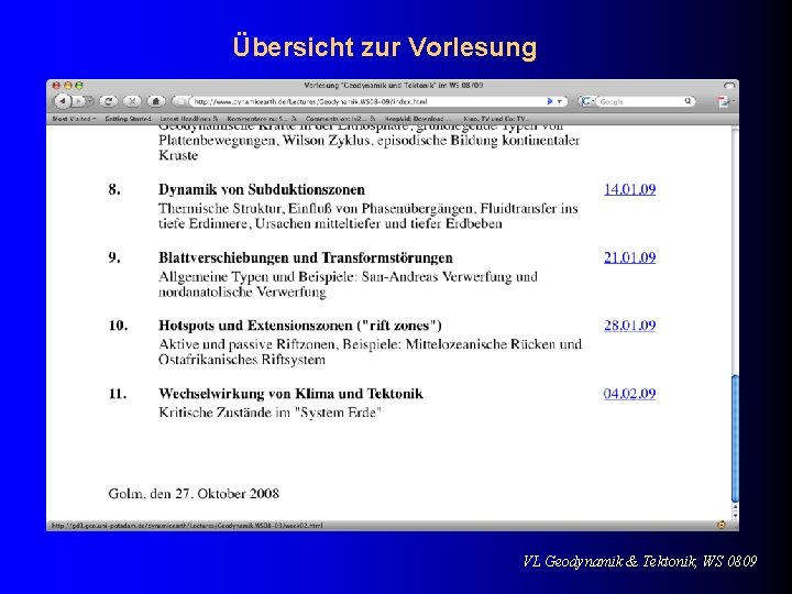
Übersicht zur Vorlesung VL Geodynamik & Tektonik, WS 0809
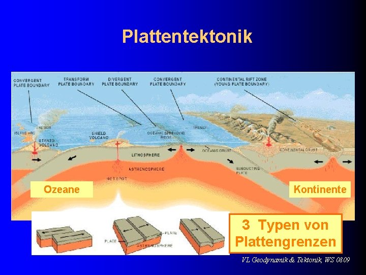
Plattentektonik Ozeane Kontinente 3 Typen von Plattengrenzen VL Geodynamik & Tektonik, WS 0809
VL Geodynamik & Tektonik, WS 0809
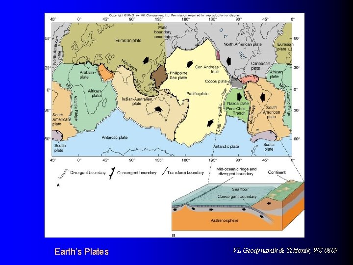
Earth’s Plates VL Geodynamik & Tektonik, WS 0809
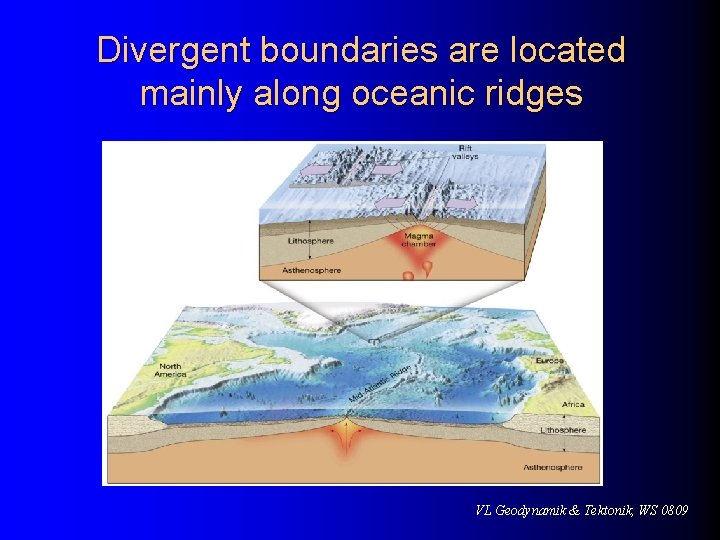
Divergent boundaries are located mainly along oceanic ridges VL Geodynamik & Tektonik, WS 0809
Divergent plate boundaries l Oceanic ridges and seafloor spreading l l Seafloor spreading occurs along the oceanic ridge system Spreading rates and ridge topography Ridge systems exhibit topographic differences l Topographic differences are controlled by spreading rates l VL Geodynamik & Tektonik, WS 0809
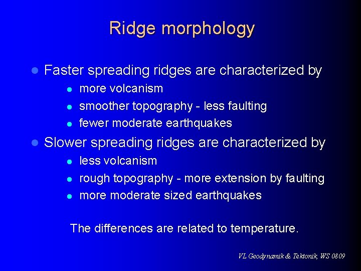
Ridge morphology l Faster spreading ridges are characterized by l l more volcanism smoother topography - less faulting fewer moderate earthquakes Slower spreading ridges are characterized by l less volcanism rough topography - more extension by faulting more moderate sized earthquakes The differences are related to temperature. VL Geodynamik & Tektonik, WS 0809
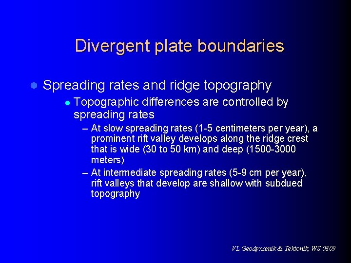
Divergent plate boundaries l Spreading rates and ridge topography l Topographic differences are controlled by spreading rates – At slow spreading rates (1 -5 centimeters per year), a prominent rift valley develops along the ridge crest that is wide (30 to 50 km) and deep (1500 -3000 meters) – At intermediate spreading rates (5 -9 cm per year), rift valleys that develop are shallow with subdued topography VL Geodynamik & Tektonik, WS 0809
Divergent plate boundaries l Spreading rates and ridge topography l Topographic differences are controlled by spreading rates – At spreading rates greater than 9 centimeters per year no median rift valley develops and these areas are usually narrow and extensively faulted l Continental rifts l Splits landmasses into two or more smaller segments VL Geodynamik & Tektonik, WS 0809
Divergent plate boundaries l Continental rifts Examples include the East African rifts valleys and the Rhine Valley in northern Europe l Produced by extensional forces acting on the lithospheric plates l Not all rift valleys develop into full-fledged spreading centers l VL Geodynamik & Tektonik, WS 0809
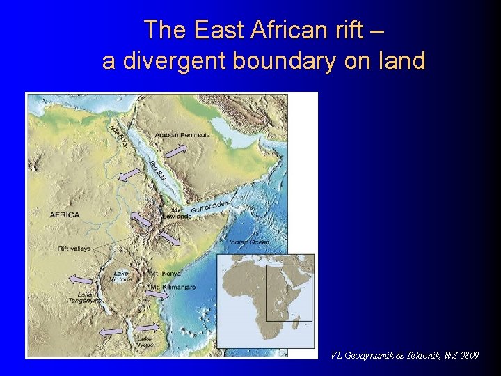
The East African rift – a divergent boundary on land VL Geodynamik & Tektonik, WS 0809
Convergent plate boundaries l Older portions of oceanic plates are returned to the mantle in these destructive plate margins Surface expression of the descending plate is an ocean trench l Called subduction zones l Average angle at which oceanic lithosphere descends into the mantle is about 45 l VL Geodynamik & Tektonik, WS 0809
Convergent plate boundaries Although all have the same basic characteristics, they are highly variable features l Types of convergent boundaries l l Oceanic-continental convergence – Denser oceanic slab sinks into the asthenosphere VL Geodynamik & Tektonik, WS 0809
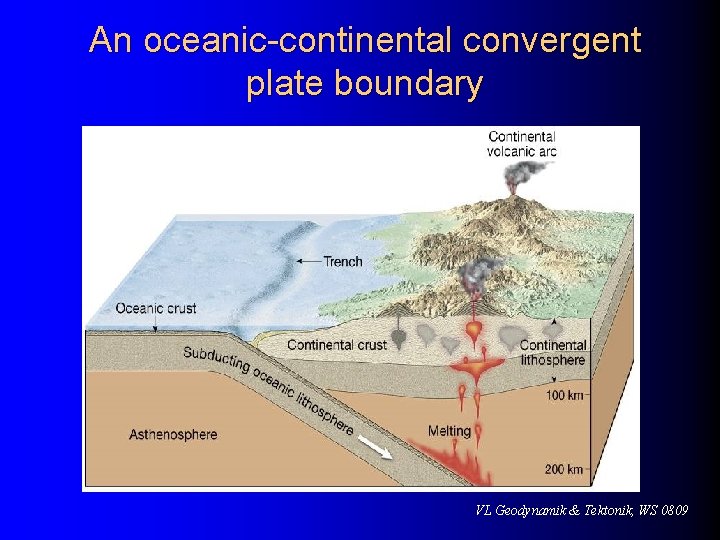
Convergent plate boundaries l Types of convergent boundaries l Oceanic-continental convergence – As the plate descends, partial melting of mantle rock generates magmas having a basaltic or, occasionally andesitic composition – Mountains produced in part by volcanic activity associated with subduction of oceanic lithosphere are called continental volcanic arcs (Andes and Cascades) VL Geodynamik & Tektonik, WS 0809
An oceanic-continental convergent plate boundary VL Geodynamik & Tektonik, WS 0809
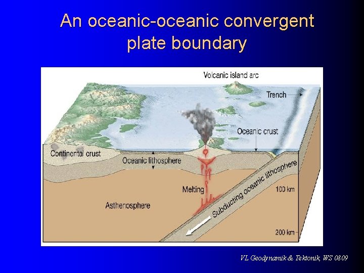
Convergent plate boundaries l Types of convergent boundaries l Oceanic-oceanic convergence – When two oceanic slabs converge, one descends beneath the other – Often forms volcanoes on the ocean floor – If the volcanoes emerge as islands, a volcanic island arc is formed (Japan, Aleutian islands, Tonga islands) VL Geodynamik & Tektonik, WS 0809
An oceanic-oceanic convergent plate boundary VL Geodynamik & Tektonik, WS 0809
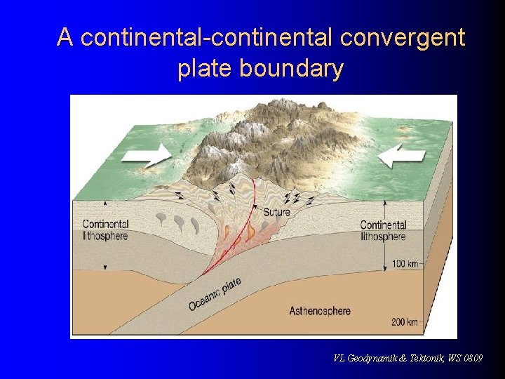
Convergent plate boundaries l Types of convergent boundaries l Continental-continental convergence – Continued subduction can bring two continents together – Less dense, buoyant continental lithosphere does not subduct – Result is a collision between two continental blocks – Process produces mountains (Himalayas, Alps, Appalachians) VL Geodynamik & Tektonik, WS 0809
A continental-continental convergent plate boundary VL Geodynamik & Tektonik, WS 0809
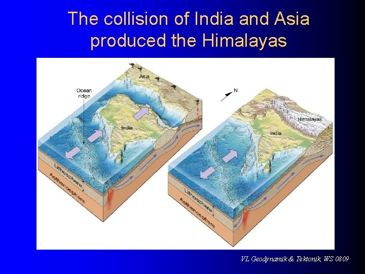
The collision of India and Asia produced the Himalayas VL Geodynamik & Tektonik, WS 0809
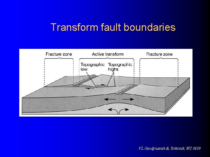
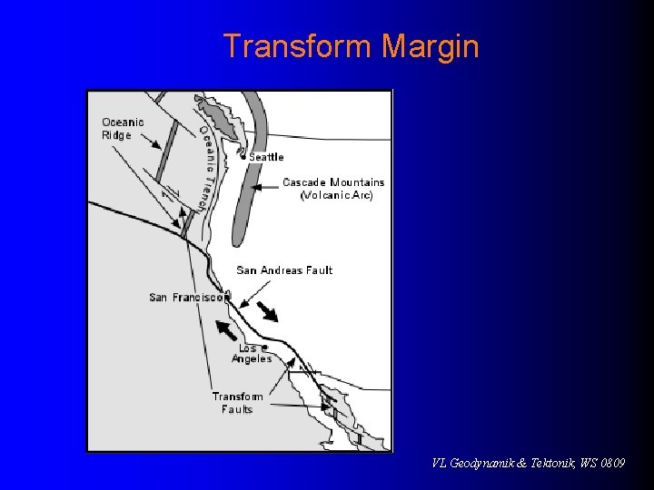
Transform fault boundaries The third type of plate boundary l Plates slide past one another and no new lithosphere is created or destroyed l Transform faults l l Most join two segments of a mid-ocean ridge as parts of prominent linear breaks in the oceanic crust known as fracture zones VL Geodynamik & Tektonik, WS 0809
Transform fault boundaries VL Geodynamik & Tektonik, WS 0809
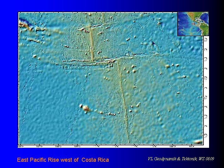
East Pacific Rise west of Costa Rica VL Geodynamik & Tektonik, WS 0809
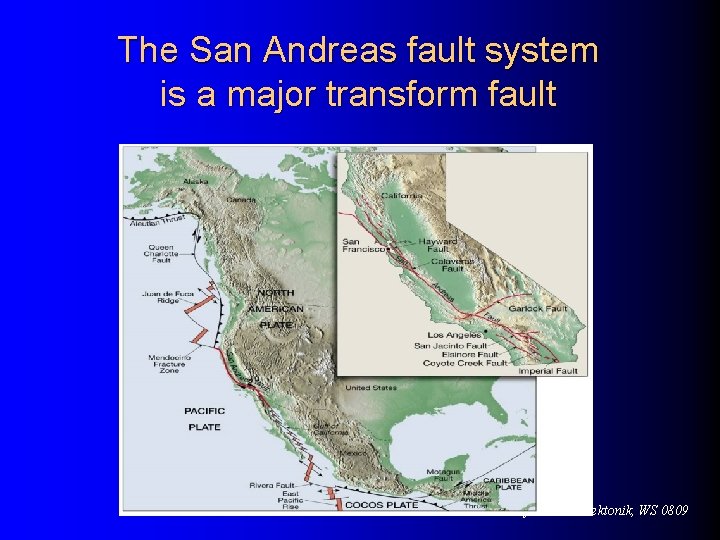
Transform fault boundaries l Transform l faults A few (the San Andreas fault and the Alpine fault of New Zealand) cut through continental crust VL Geodynamik & Tektonik, WS 0809
Transform Margin VL Geodynamik & Tektonik, WS 0809
Testing the plate tectonics model l Paleomagnetism Ancient magnetism preserved in rocks at the time of their formation l Magnetized minerals in rocks l – Show the direction to Earth’s magnetic poles – Provide a means of determining their latitude of origin VL Geodynamik & Tektonik, WS 0809
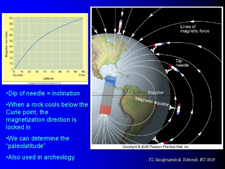
• Dip of needle = inclination • When a rock cools below the Curie point, the magnetization direction is locked in • We can determine the “paleolatitude” • Also used in archeology VL Geodynamik & Tektonik, WS 0809
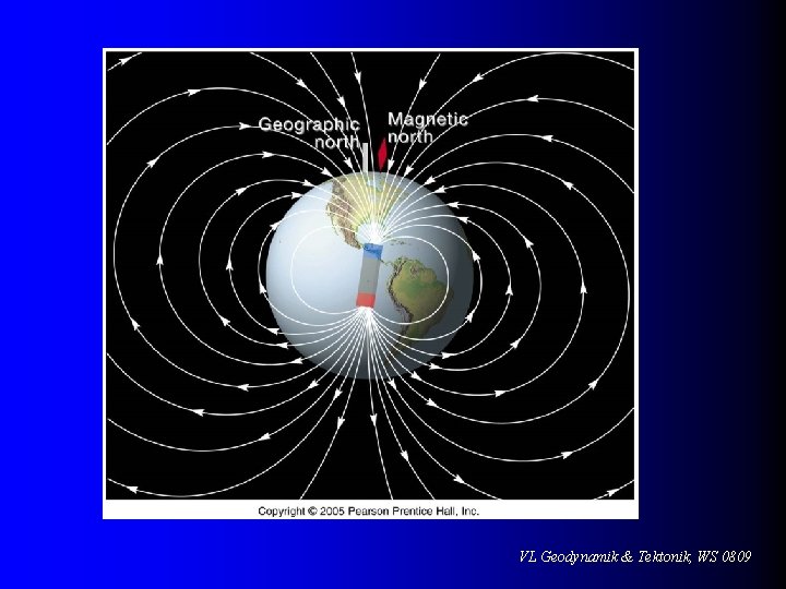
VL Geodynamik & Tektonik, WS 0809
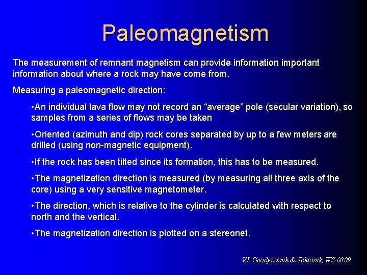
Paleomagnetism The measurement of remnant magnetism can provide information important information about where a rock may have come from. Measuring a paleomagnetic direction: • An individual lava flow may not record an “average” pole (secular variation), so samples from a series of flows may be taken • Oriented (azimuth and dip) rock cores separated by up to a few meters are drilled (using non-magnetic equipment). • If the rock has been tilted since its formation, this has to be measured. • The magnetization direction is measured (by measuring all three axis of the core) using a very sensitive magnetometer. • The direction, which is relative to the cylinder is calculated with respect to north and the vertical. • The magnetization direction is plotted on a stereonet. VL Geodynamik & Tektonik, WS 0809
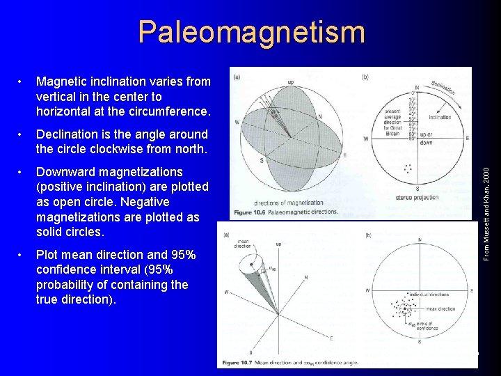
• Magnetic inclination varies from vertical in the center to horizontal at the circumference. • Declination is the angle around the circle clockwise from north. • Downward magnetizations (positive inclination) are plotted as open circle. Negative magnetizations are plotted as solid circles. • Plot mean direction and 95% confidence interval (95% probability of containing the true direction). From Mussett and Khan, 2000 Paleomagnetism VL Geodynamik & Tektonik, WS 0809
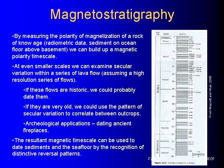
Magnetostratigraphy • At even smaller scales we can examine secular variation within a series of lava flow (assuming a high resolution series of flows). • If these flows are historic, we could probably date them. • If they are very old, we could use the pattern of secular variation to correlate between outcrops. From Mussett and Khan, 2000 • By measuring the polarity of magnetization of a rock of know age (radiometric data, sediment on ocean floor above basement) we can build up a magnetic polarity timescale. • Archeological applications – dating ancient fireplaces. • The resultant magnetic timescale can be used to date sediments and the seafloor by the recognition of distinctive reversal patterns. VL Geodynamik & Tektonik, WS 0809
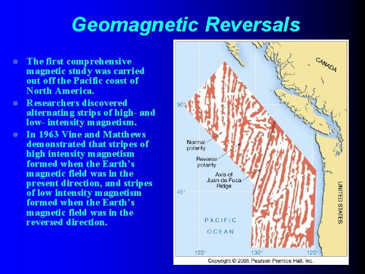
Geomagnetic Reversals The first comprehensive magnetic study was carried out off the Pacific coast of North America. l Researchers discovered alternating strips of high- and low- intensity magnetism. l In 1963 Vine and Matthews demonstrated that stripes of high intensity magnetism formed when the Earth’s magnetic field was in the present direction, and stripes of low intensity magnetism formed when the Earth’s magnetic field was in the reversed direction. l VL Geodynamik & Tektonik, WS 0809
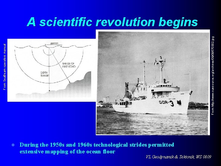
From Sea. Beam operators manual From http: //www. navsource. org/archives/09/09570302. jpg A scientific revolution begins l During the 1950 s and 1960 s technological strides permitted extensive mapping of the ocean floor VL Geodynamik & Tektonik, WS 0809
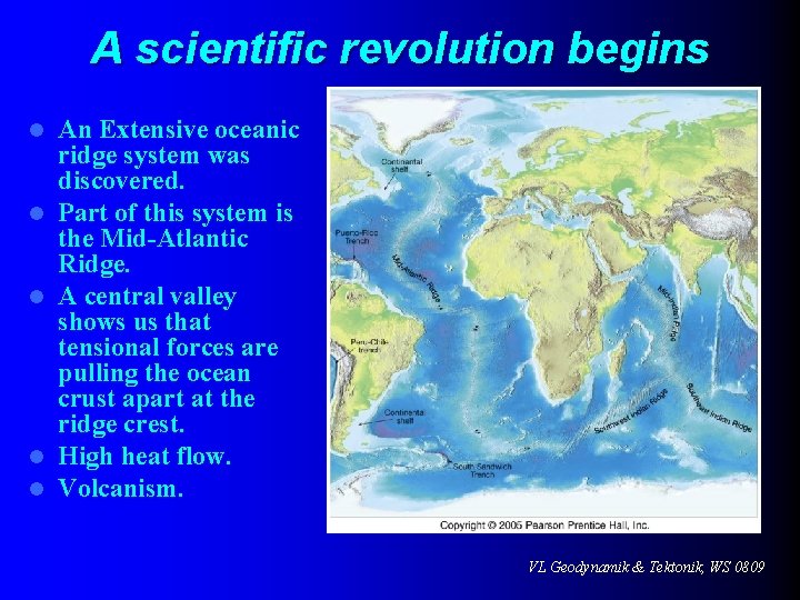
A scientific revolution begins l l l An Extensive oceanic ridge system was discovered. Part of this system is the Mid-Atlantic Ridge. A central valley shows us that tensional forces are pulling the ocean crust apart at the ridge crest. High heat flow. Volcanism. VL Geodynamik & Tektonik, WS 0809
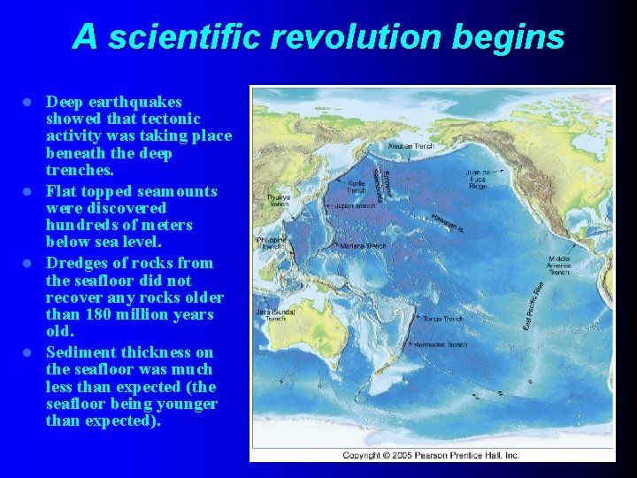
A scientific revolution begins Deep earthquakes showed that tectonic activity was taking place beneath the deep trenches. l Flat topped seamounts were discovered hundreds of meters below sea level. l Dredges of rocks from the seafloor did not recover any rocks older than 180 million years old. l Sediment thickness on the seafloor was much less than expected (the seafloor being younger than expected). l VL Geodynamik & Tektonik, WS 0809
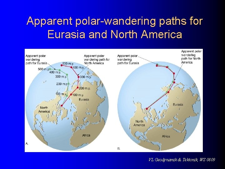
Testing the plate tectonics model l Paleomagnetism l Polar wandering – The apparent movement of the magnetic poles illustrated in magnetized rocks indicates that the continents have moved – Polar wandering curves for North America and Europe have similar paths but are separated by about 24 of longitude – Different paths can be reconciled if the continents are place next to one another VL Geodynamik & Tektonik, WS 0809
Apparent polar-wandering paths for Eurasia and North America VL Geodynamik & Tektonik, WS 0809
Testing the plate tectonics model l Magnetic reversals and seafloor spreading Earth's magnetic field periodically reverses polarity – the north magnetic pole becomes the south magnetic pole, and vice versa l Dates when the polarity of Earth’s magnetism changed were determined from lava flows l VL Geodynamik & Tektonik, WS 0809
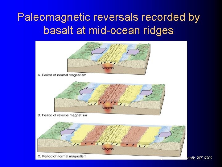
Testing the plate tectonics model l Magnetic reversals and seafloor spreading Geomagnetic reversals are recorded in the ocean crust l In 1963 the discovery of magnetic stripes in the ocean crust near ridge crests was tied to the concept of seafloor spreading l VL Geodynamik & Tektonik, WS 0809
Paleomagnetic reversals recorded by basalt at mid-ocean ridges VL Geodynamik & Tektonik, WS 0809
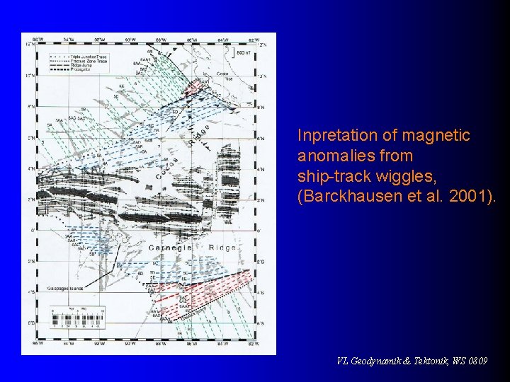
Inpretation of magnetic anomalies from ship-track wiggles, (Barckhausen et al. 2001). VL Geodynamik & Tektonik, WS 0809
Testing the plate tectonics model l Magnetic reversals and seafloor spreading Paleomagnetism (evidence of past magnetism recorded in the rocks) was the most convincing evidence set forth to support the concept of seafloor spreading l The Pacific has a faster spreading rate than the Atlantic l VL Geodynamik & Tektonik, WS 0809
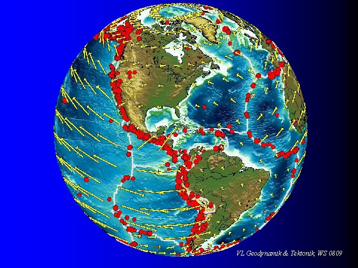
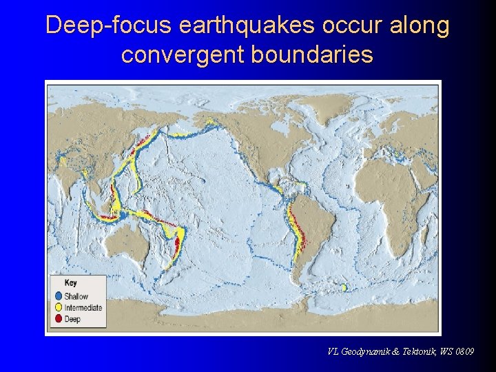
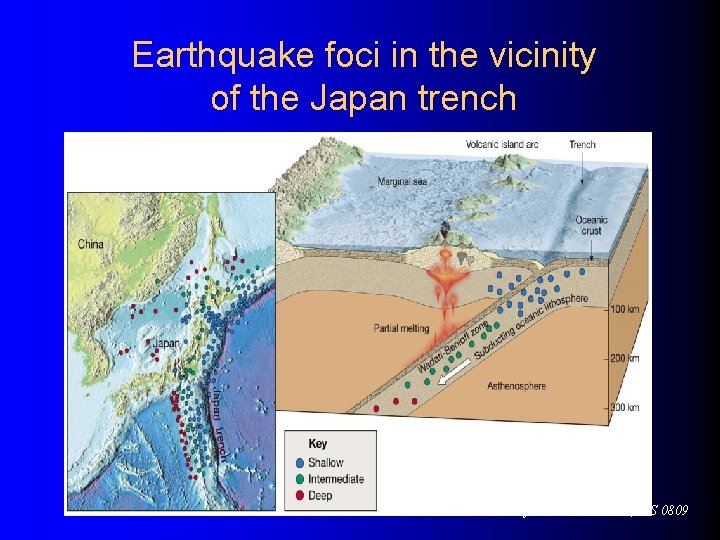
Testing the plate tectonics model l Plate tectonics and earthquakes l Plate tectonics model accounts for the global distribution of earthquakes – Absence of deep-focus earthquakes along the oceanic ridge is consistent with plate tectonics theory – Deep-focus earthquakes are closely associated with subduction zones – The pattern of earthquakes along a trench provides a method for tracking the plate's descent VL Geodynamik & Tektonik, WS 0809
Deep-focus earthquakes occur along convergent boundaries VL Geodynamik & Tektonik, WS 0809
Earthquake foci in the vicinity of the Japan trench VL Geodynamik & Tektonik, WS 0809
Testing the plate tectonics model l Evidence l from ocean drilling Some of the most convincing evidence confirming seafloor spreading has come from drilling directly into ocean-floor sediment – Age of deepest sediments – Thickness of ocean-floor sediments verifies seafloor spreading VL Geodynamik & Tektonik, WS 0809
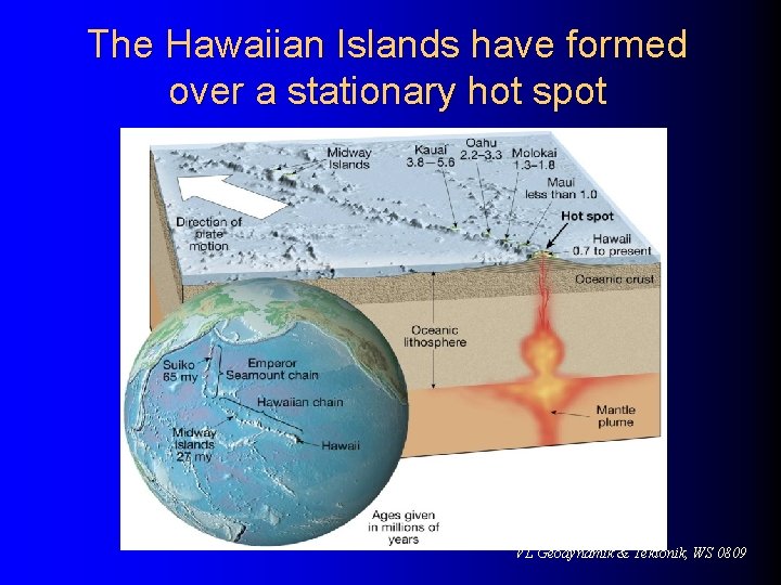
Testing the plate tectonics model l Hot spots Caused by rising plumes of mantle material l Volcanoes can form over them (Hawaiian Island chain) l Most mantle plumes are long-lived structures and at least some originate at great depth, perhaps at the mantle-core boundary l VL Geodynamik & Tektonik, WS 0809
The Hawaiian Islands have formed over a stationary hot spot VL Geodynamik & Tektonik, WS 0809
Measuring plate motions l. A number of methods have been employed to establish the direction and rate of plate motion Volcanic chains l Paleomagnetism l Very Long Baseline Interferometry (VLBI) l Global Positioning System (GPS) l VL Geodynamik & Tektonik, WS 0809
Measuring plate motions l Calculations show that Hawaii is moving in a northwesterly direction and approaching Japan at 8. 3 centimeters per year l A site located in Maryland is retreating from one in England at a rate of about 1. 7 centimeters per year l VL Geodynamik & Tektonik, WS 0809
The driving mechanism No one driving mechanism accounts for all major facets of plate tectonics l Several mechanisms generate forces that contribute to plate motion l Ridge push l Slab pull l Models – Layering at 660 kilometers – Whole-mantle convection – Deep-layer model l VL Geodynamik & Tektonik, WS 0809
Deformation l Deformation is a general term that refers to all changes in the original form and/or size of a rock body l Most crustal deformation occurs along plate margins l How rocks deform l Rocks subjected to stresses greater than their own strength begin to deform usually by folding, flowing, or fracturing VL Geodynamik & Tektonik, WS 0809
Faults are fractures in rocks along which appreciable displacement has taken place l Sudden movements along faults are the cause of most earthquakes l Classified by their relative movement which can be l l Horizontal, vertical, or oblique VL Geodynamik & Tektonik, WS 0809
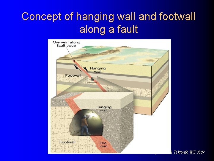
Faults l Types l of faults Dip-slip faults – Movement is mainly parallel to the dip of the fault surface – May produce long, low cliffs called fault scarps – Parts of a dip-slip fault include the hanging wall (rock surface above the fault) and the footwall (rock surface below the fault) VL Geodynamik & Tektonik, WS 0809
Concept of hanging wall and footwall along a fault VL Geodynamik & Tektonik, WS 0809
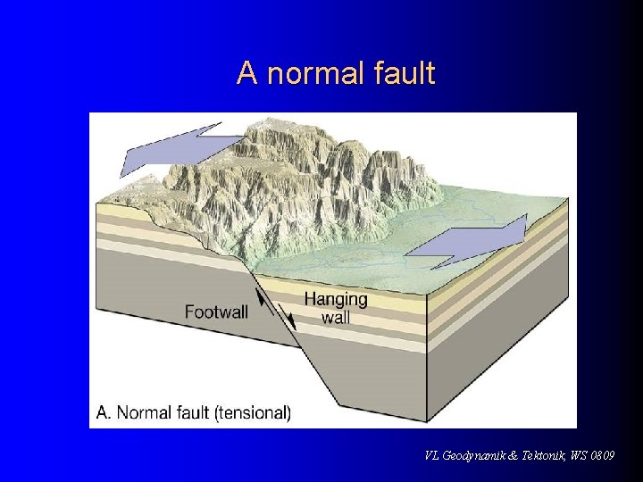
Faults l Types of dip-slip faults – Normal fault • Hanging wall block moves down relative to the footwall block • Accommodate lengthening or extension of the crust • Most are small with displacements of a meter or so • Larger scale normal faults are associated with structures called fault-block mountains VL Geodynamik & Tektonik, WS 0809
A normal fault VL Geodynamik & Tektonik, WS 0809
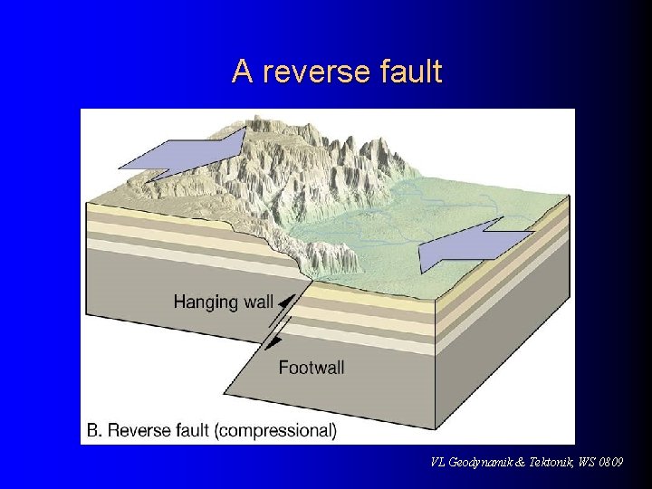
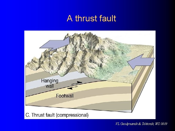
Faults l Types of dip-slip faults – Reverse and thrust faults • Hanging wall block moves up relative to the footwall block • Reverse faults have dips greater than 45 o and thrust faults have dips less then 45 o • Accommodate shortening of the crust • Strong compressional forces VL Geodynamik & Tektonik, WS 0809
A reverse fault VL Geodynamik & Tektonik, WS 0809
A thrust fault VL Geodynamik & Tektonik, WS 0809
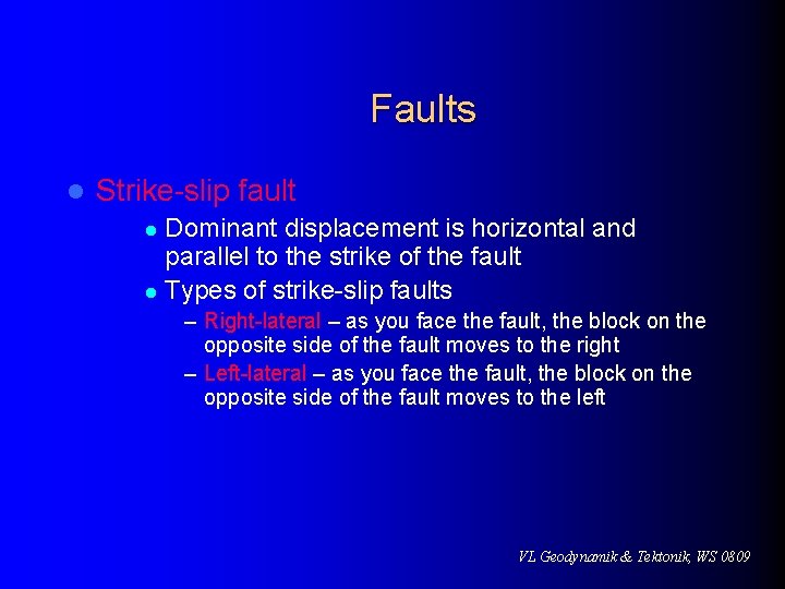
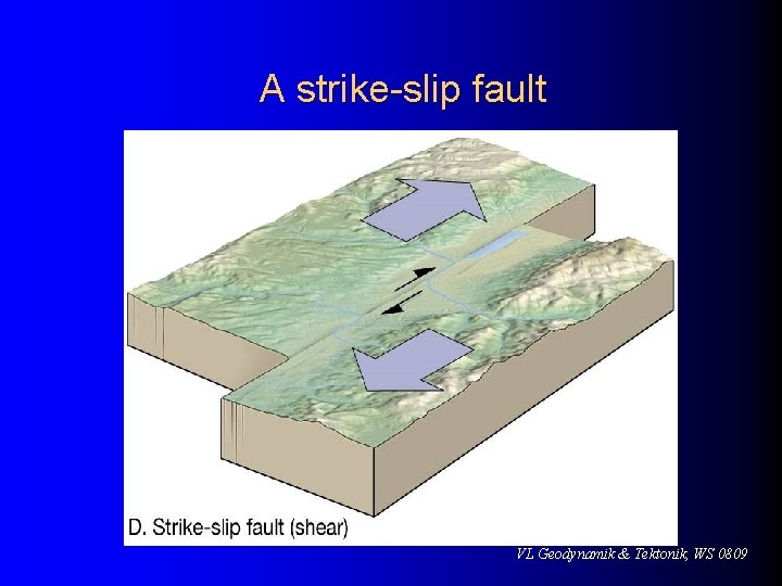
Faults l Strike-slip fault Dominant displacement is horizontal and parallel to the strike of the fault l Types of strike-slip faults l – Right-lateral – as you face the fault, the block on the opposite side of the fault moves to the right – Left-lateral – as you face the fault, the block on the opposite side of the fault moves to the left VL Geodynamik & Tektonik, WS 0809
A strike-slip fault VL Geodynamik & Tektonik, WS 0809
Fault l Strike-slip l fault Transform fault – Large strike-slip fault that cuts through the lithosphere – Accommodates motion between two large crustal plates VL Geodynamik & Tektonik, WS 0809
The San Andreas fault system is a major transform fault VL Geodynamik & Tektonik, WS 0809
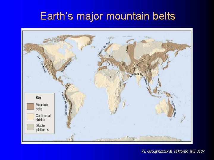
Mountain belts l Orogenesis – the processes that collectively produce a mountain belt l Includes folding, thrust faulting, metamorphism, and igneous activity l Mountain building has occurred during the recent geologic past Alpine-Himalayan chain l American Cordillera l Mountainous terrains of the western Pacific l VL Geodynamik & Tektonik, WS 0809
Earth’s major mountain belts VL Geodynamik & Tektonik, WS 0809
Mountain belts l Older Paleozoic- and Precambrian-age mountains Appalachians l Urals in Russia l l Several hypotheses have been proposed for the formations of Earth’s mountain belts VL Geodynamik & Tektonik, WS 0809
Mountain building at convergent boundaries l Plate tectonics provides a model for orogenesis l l Mountain building occurs at convergent plate boundaries Of particular interest are active subduction zones – Volcanic arcs are typified by the Aleutian Islands and the Andean arc of western South America VL Geodynamik & Tektonik, WS 0809
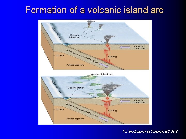
Mountain building at convergent boundaries l Aleutian-type mountain building l l Where two ocean plates converge and one is subducted beneath the other Volcanic island arcs result from the steady subduction of oceanic lithosphere – Most are found in the Pacific – Active island arcs include the Mariana, New Hebrides, Tonga, and Aleutian arcs VL Geodynamik & Tektonik, WS 0809
Mountain building at convergent boundaries l Aleutian-type mountain building l Volcanic island arcs – Continued development can result in the formation of mountainous topography consisting of igneous and metamorphic rocks VL Geodynamik & Tektonik, WS 0809
Formation of a volcanic island arc VL Geodynamik & Tektonik, WS 0809
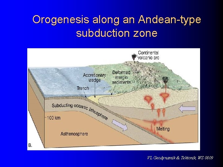
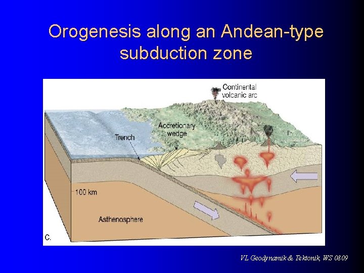
Mountain building at convergent boundaries l Andean-type mountain building l Mountain building along continental margins – Involves the convergence of an oceanic plate and a plate whose leading edge contains continental crust – Exemplified by the Andes Mountains VL Geodynamik & Tektonik, WS 0809
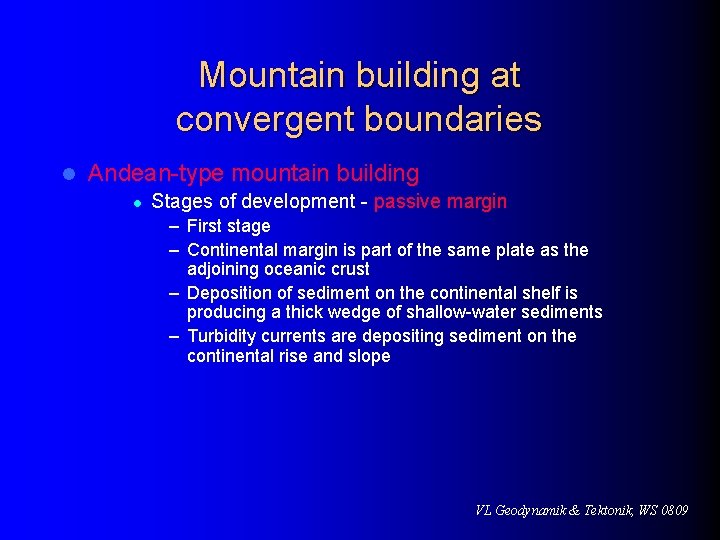
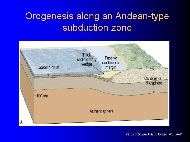
Mountain building at convergent boundaries l Andean-type mountain building l Stages of development - passive margin – First stage – Continental margin is part of the same plate as the adjoining oceanic crust – Deposition of sediment on the continental shelf is producing a thick wedge of shallow-water sediments – Turbidity currents are depositing sediment on the continental rise and slope VL Geodynamik & Tektonik, WS 0809
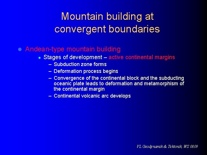
Mountain building at convergent boundaries l Andean-type mountain building l Stages of development – active continental margins – Subduction zone forms – Deformation process begins – Convergence of the continental block and the subducting oceanic plate leads to deformation and metamorphism of the continental margin – Continental volcanic arc develops VL Geodynamik & Tektonik, WS 0809
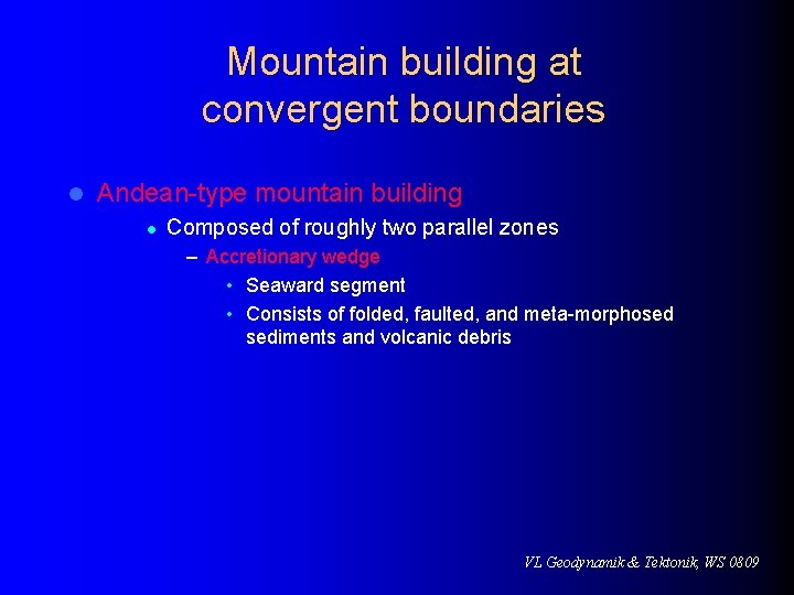
Mountain building at convergent boundaries l Andean-type mountain building l Composed of roughly two parallel zones – Accretionary wedge • Seaward segment • Consists of folded, faulted, and meta-morphosed sediments and volcanic debris VL Geodynamik & Tektonik, WS 0809
Orogenesis along an Andean-type subduction zone VL Geodynamik & Tektonik, WS 0809
Orogenesis along an Andean-type subduction zone VL Geodynamik & Tektonik, WS 0809
Orogenesis along an Andean-type subduction zone VL Geodynamik & Tektonik, WS 0809
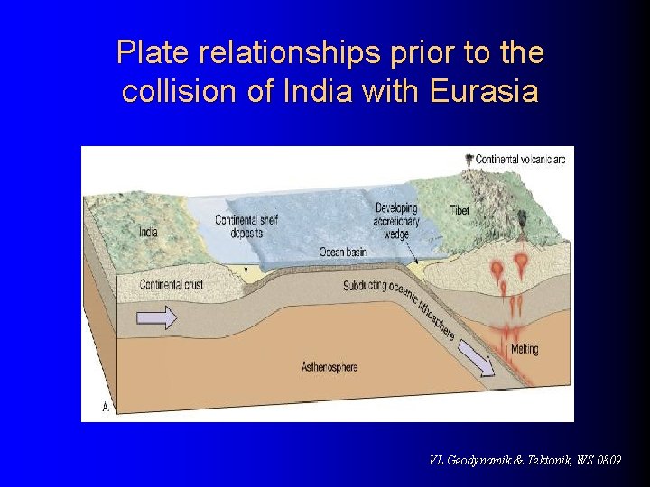
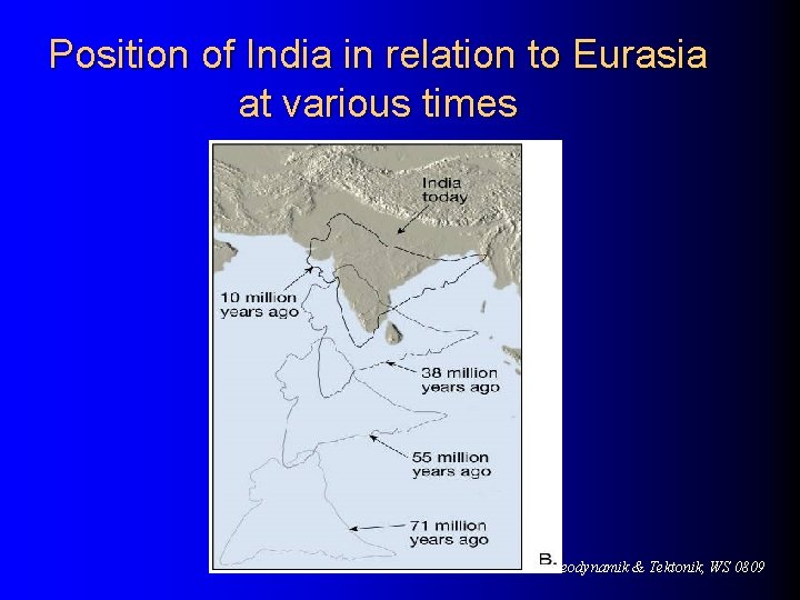
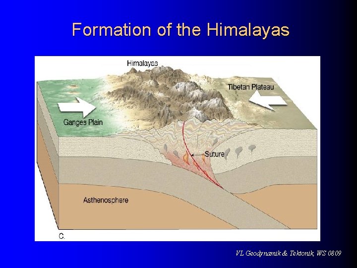
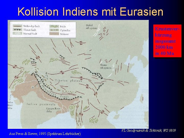
Mountain building at convergent boundaries l Continental collisions l l Two lithospheric plates, both carrying continental crust The Himalayan Mountains are a youthful mountain range formed from the collision of India with the Eurasian plate about 45 million years ago VL Geodynamik & Tektonik, WS 0809
Mountain building at convergent boundaries l Continental collisions l The Himalayan Mountains – Spreading center that propelled India northward is still active – Similar but older collision occurred when the European continent collided with the Asian continent to produce the Ural mountains VL Geodynamik & Tektonik, WS 0809
Plate relationships prior to the collision of India with Eurasia VL Geodynamik & Tektonik, WS 0809
Position of India in relation to Eurasia at various times VL Geodynamik & Tektonik, WS 0809
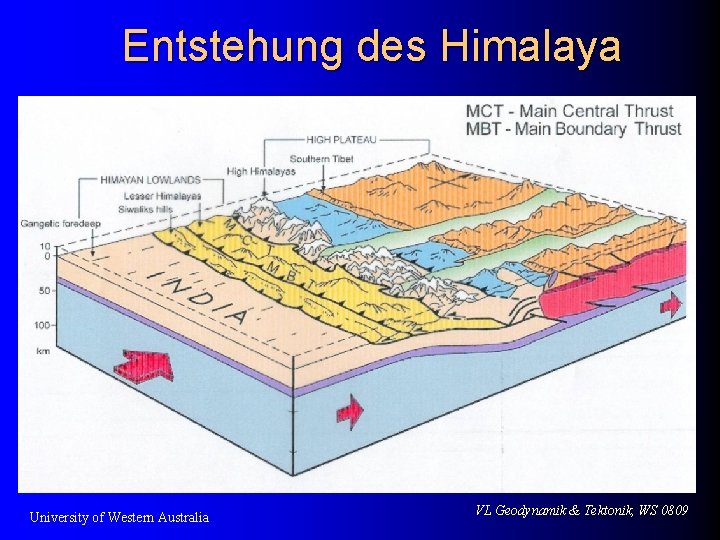
Formation of the Himalayas VL Geodynamik & Tektonik, WS 0809
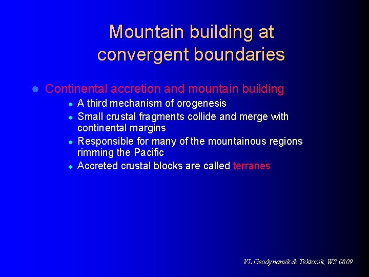
Mountain building at convergent boundaries l Continental accretion and mountain building l l A third mechanism of orogenesis Small crustal fragments collide and merge with continental margins Responsible for many of the mountainous regions rimming the Pacific Accreted crustal blocks are called terranes VL Geodynamik & Tektonik, WS 0809
Mountain building at convergent boundaries l Continental accretion and mountain building l l Terranes consist of any crustal fragments whose geologic history is distinct from that of the adjoining terranes As oceanic plates move, they carry embedded oceanic plateaus, volcanic island arcs and microcontinents to an Andean-type subduction zone VL Geodynamik & Tektonik, WS 0809
Vertical movements of the crust l In addition to the horizontal movements of lithospheric plates, vertical movement also occurs along plate margins as well as the interiors of continents far from plate boundaries VL Geodynamik & Tektonik, WS 0809
Vertical movements of the crust l Isostatic adjustment Less dense crust floats on top of the denser and deformable rocks of the mantle l Concept of floating crust in gravitational balance is called isostasy l If weight is added or removed from the crust, isostatic adjustment will take place as the crust subsides or rebounds l VL Geodynamik & Tektonik, WS 0809
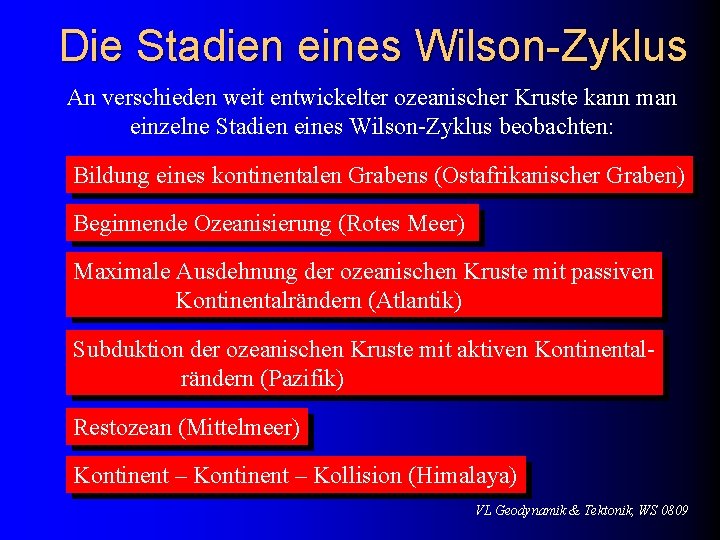
Der Wilson-Zyklus Ein Wilson-Zyklus beschreibt die Entstehung, die Entwicklung und das Verschwinden eines Ozeans. Die einzelnen Stadien sind: Zerbrechen kontinentaler Kruste, Entstehung einer ozeanischen Spreizungszone, maximale Ausdehnung der Ozeanischen Kruste, Subduktion, Verschwinden der ozeanischen. Kruste, Kontinent – Kontinent - Kollision VL Geodynamik & Tektonik, WS 0809
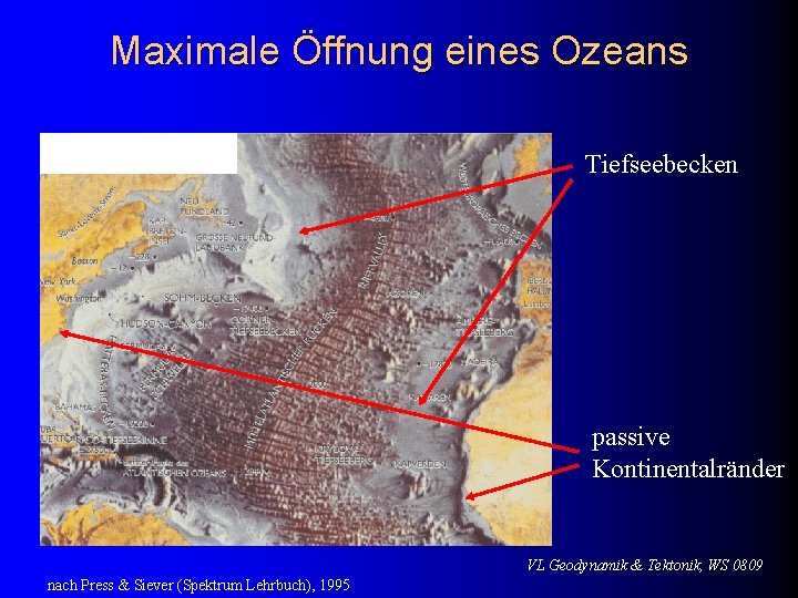
Die Stadien eines Wilson-Zyklus An verschieden weit entwickelter ozeanischer Kruste kann man einzelne Stadien eines Wilson-Zyklus beobachten: Bildung eines kontinentalen Grabens (Ostafrikanischer Graben) Beginnende Ozeanisierung (Rotes Meer) Maximale Ausdehnung der ozeanischen Kruste mit passiven Kontinentalrändern (Atlantik) Subduktion der ozeanischen Kruste mit aktiven Kontinentalrändern (Pazifik) Restozean (Mittelmeer) Kontinent – Kollision (Himalaya) VL Geodynamik & Tektonik, WS 0809
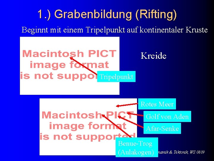
1. ) Grabenbildung (Rifting) Beginnt mit einem Tripelpunkt auf kontinentaler Kruste Kreide Tripelpunkt Rotes Meer Golf von Aden Afar-Senke Rezent Benue-Trog VL Geodynamik & Tektonik, WS 0809 (Aulakogen)
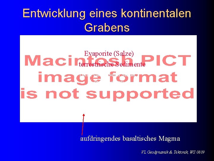
Entwicklung eines kontinentalen Grabens Evaporite (Salze) terrestrische Sedimente Tuffe, vulkanischer Schutt Lavadecken aufdringendes basaltisches Magma VL Geodynamik & Tektonik, WS 0809
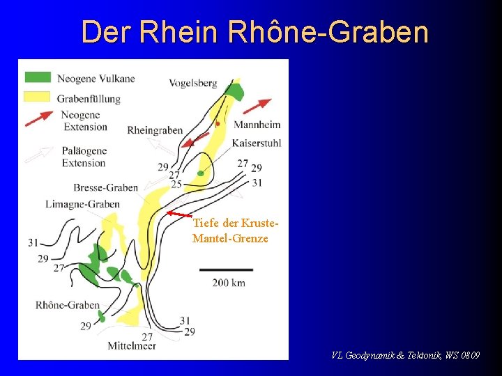
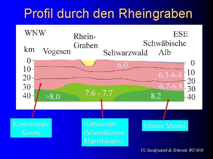
Der Rhein Rhône-Graben Tiefe der Kruste. Mantel-Grenze VL Geodynamik & Tektonik, WS 0809
Profil durch den Rheingraben Kontinentale Kruste Asthenolith (Mantelkissen, Manteldiapir) Oberer Mantel VL Geodynamik & Tektonik, WS 0809
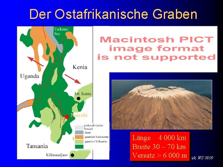
Der Ostafrikanische Graben Nairobi Länge 4 000 km Breite 30 – 70 km Versatz > 6 000& Tektonik, m WS 0809 VL Geodynamik
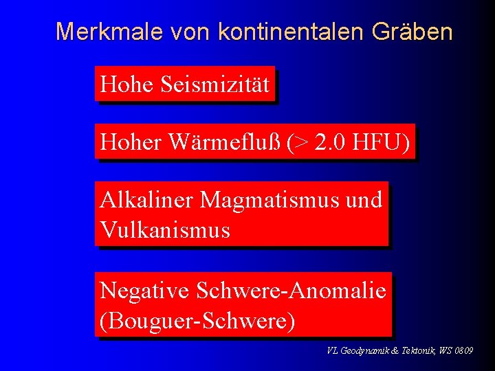
Merkmale von kontinentalen Gräben Hohe Seismizität Hoher Wärmefluß (> 2. 0 HFU) Alkaliner Magmatismus und Vulkanismus Negative Schwere-Anomalie (Bouguer-Schwere) VL Geodynamik & Tektonik, WS 0809
Schwere-Anomalie Gemessen wird die Erdbeschleunigung in gal 1 gal = 1 cm/sec 2 = 1000 mgal. normal: 980 gal hochliegende Moho Bouguer- leichte Sedimente Schwere VL Geodynamik & Tektonik, WS 0809
2. ) Stadium Bildung eines mittelozeanischen Rückens VL Geodynamik & Tektonik, WS 0809
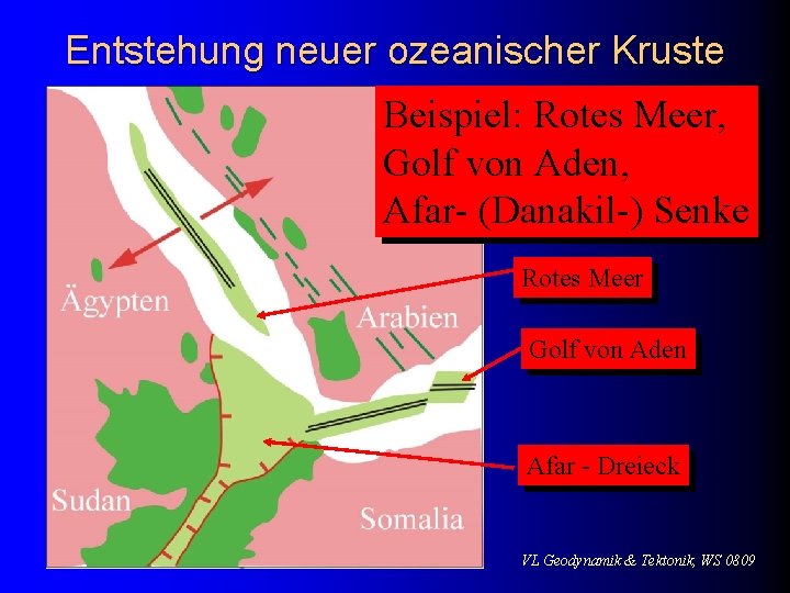
Entstehung neuer ozeanischer Kruste Beispiel: Rotes Meer, Golf von Aden, Afar- (Danakil-) Senke Rotes Meer Golf von Aden Afar - Dreieck VL Geodynamik & Tektonik, WS 0809
Unterschiede zu Gräben Entstehung ozeanischer Kruste Positive Bouguer-Anomalie VL Geodynamik & Tektonik, WS 0809
3. Stadium Ausbreitung ozeanischer Lithosphäre VL Geodynamik & Tektonik, WS 0809
Maximale Öffnung eines Ozeans Beispiel Atlantik Tiefseebecken passive Kontinentalränder VL Geodynamik & Tektonik, WS 0809 nach Press & Siever (Spektrum Lehrbuch), 1995
Profil durch den Atlantik Schematisches Profil durch den Nordatlantik VL Geodynamik & Tektonik, WS 0809
Stadium 4 Subduktion ozeanischer Kruste (rezentes Beispiel: Pazifik) VL Geodynamik & Tektonik, WS 0809
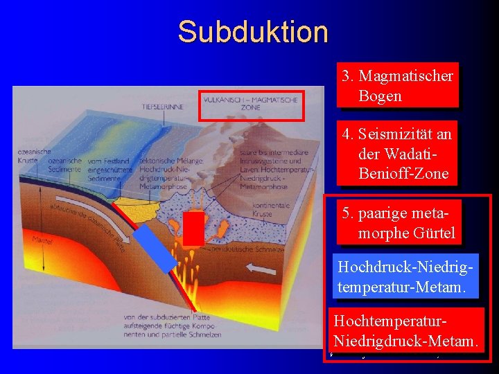
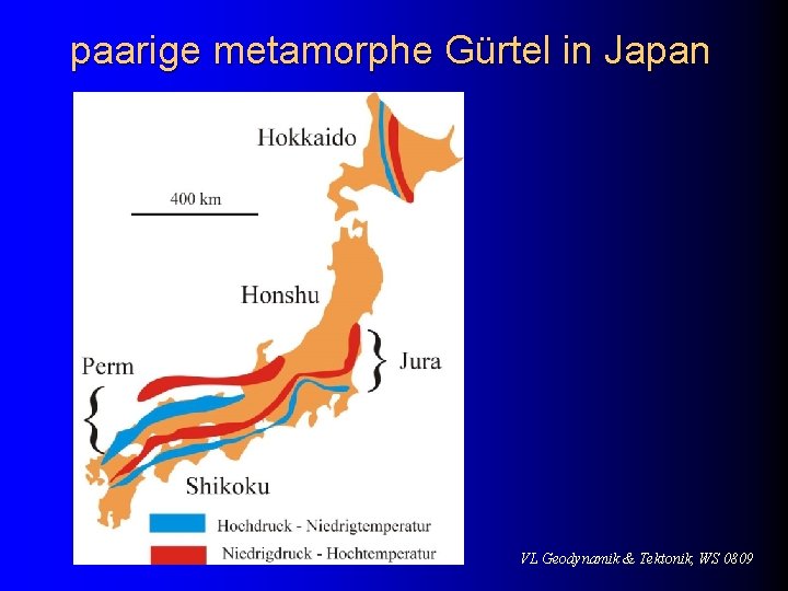
Subduktion 3. Magmatischer Bogen 4. Seismizität an der Wadati. Benioff-Zone 5. paarige metamorphe Gürtel Hochdruck-Niedrigtemperatur-Metam. Hochtemperatur. Niedrigdruck-Metam. VL Geodynamik & Tektonik, WS 0809
paarige metamorphe Gürtel in Japan VL Geodynamik & Tektonik, WS 0809
Fossile Subduktionszonen: Eine ehemalige Subduktionszone erkennt man am Vorhandensein von: Ophiolithen (Ophiolithische Sutur) magmatischen Gesteinen Hochdruck-Gesteinen (Blauschiefer) VL Geodynamik & Tektonik, WS 0809
Bildung von Randbecken High Stress Subduktion steiler Eintauchwinkel Low Stress Subduktion VL Geodynamik & Tektonik, WS 0809
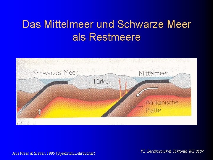
Stadium 5 Restmeer (Beispiel: Mittelmeer) VL Geodynamik & Tektonik, WS 0809
Das Mittelmeer und Schwarze Meer als Restmeere Aus Press & Siever, 1995 (Spektrum Lehrbücher) VL Geodynamik & Tektonik, WS 0809
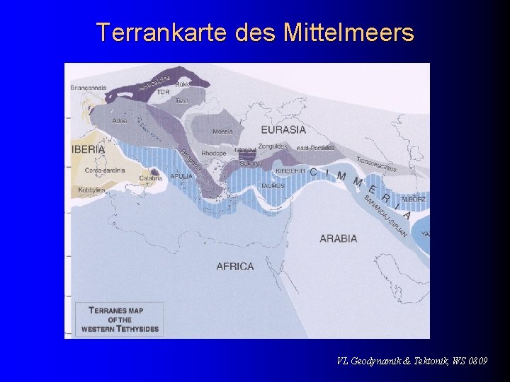
Terrankarte des Mittelmeers VL Geodynamik & Tektonik, WS 0809
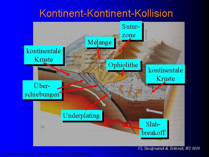
Stadium 6 Kontinent-Kollision VL Geodynamik & Tektonik, WS 0809
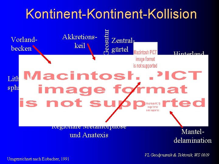
Vorlandbecken Akkretionskeil Geosutur Kontinent-Kollision Zentralgürtel Hinterland Lithosphäre Asthenosphäre Regionale Metamorphose und Anatexis Umgezeichnet nach Eisbacher, 1991 Manteldelamination VL Geodynamik & Tektonik, WS 0809
Kontinent-Kollision Mélange kontinentale Kruste Suturzone Ophiolithe Überschiebungen kontinentale Kruste Underplating Slabbreakoff VL Geodynamik & Tektonik, WS 0809 Umgezeichnet nach Press & Siever, 1995 (Spektrum)
Kollision Indiens mit Eurasien Krustenverkürzung insgesamt 2000 km in 40 Ma Aus Press & Siever, 1995 (Spektrum Lehrbücher) VL Geodynamik & Tektonik, WS 0809
Entstehung des Himalaya University of Western Australia VL Geodynamik & Tektonik, WS 0809
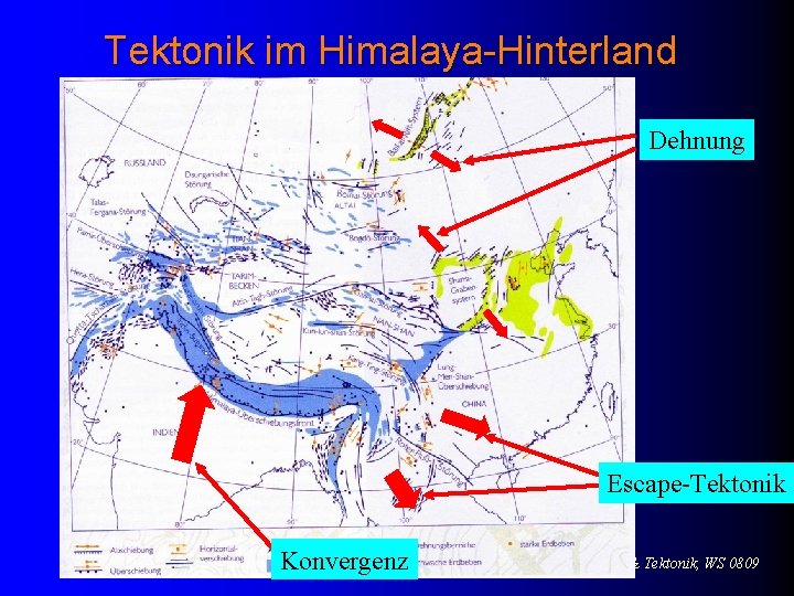
Tektonik im Himalaya-Hinterland Dehnung Escape-Tektonik Konvergenz VL Geodynamik & Tektonik, WS 0809
Zusammenfassung Die Plattentektonik ist der an der Erdoberfläche auftretende Ausdruck der Mantelkonvektion im Erdinneren. Sie beschreibt die Bewegungen der Lithosphärenplatten und die daraus resultierenden geologischen Prozesse. Zu diesen zählen u. a. die Entstehung von Faltengebirgen („Orogenese“), von mittelozeansichen Rücken und von Transformstörungen. Die großräumigen Deformationen der Lithosphäre sind wiederum die Ursache von zahlreichen geophysikalischen Phänomenen, wie z. B. Vulkanismus oder Seismizität. 21. 01. 2009 VL Geodynamik & Tektonik, WS 0809