Climate Heat transferhow heat is moved through the


 – angle at which the Sun heats the")


 o 23.")


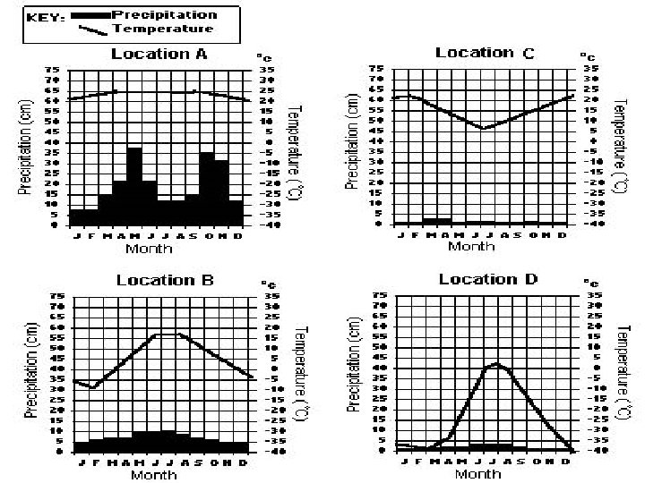
- shows precipitation and temperature of a location bars = precipitation lines")


 Latitude- distance from equator 2) Altitude- (mountain) 3) Global")


 and leaves as long-wave")


- Slides: 54
Climate
Heat transfer-how heat is moved through the atmospherealways transferred from warmer to cooler object • 1. Conduction- heat transferred through direct contact. (Ex: metal spoon in boiling pot) • 2. Radiation- heat transferred from sun to earth’s surface • 3. Convection- cycle of warm rising, cool sinking due to differences in density ( Ex: Magma inside the earth, warm & cold fronts)
What type of heat transfer is this? How is the heat transferred?
Angle of Insolation (incoming solar radiation) – angle at which the Sun heats the earth
Three Things Can Happen to Light Refraction - if the object is transparent or translucent light will pass through the object and may be bent. 2. Reflection - light may reflect from the surface of the object, 1. 3 Absorption – Upon striking an object light may be converted to heat.
Definition • Climate is the average weather in a location over a long period of time. Ex: A place that doesn't get much rain over many years would have a dry climate. – A place where it stays cold for most of the year would have a cold climate.
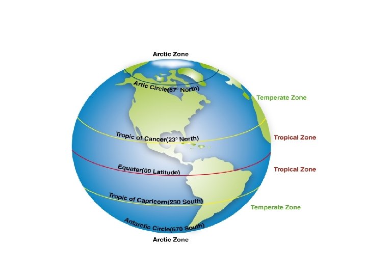
World Climates- 3 main groups o 0 -23. 5 1 -Low-latitude (Tropical) o 23. 5 -66. 5 2 -Mid-latitude (Temperate) o 66. 5 -90 3 -High-latitude (Polar)
Latitude • Latitude: The distance from the equator measured in degrees • Temperature Zones – Tropical Zones: warm climates – Temperate Zones: ranging temperatures (seasonal) – Polar Zones: cold climates
Classifying Climate • Temperature • Precipitation 6 major climate groups 1. Tropical rainy 2. Dry 3. Temperate marine 4. Temperate continental 5. Polar 6. Highlands
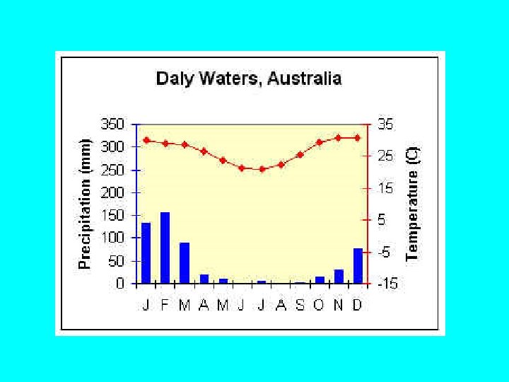
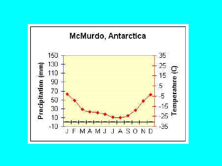
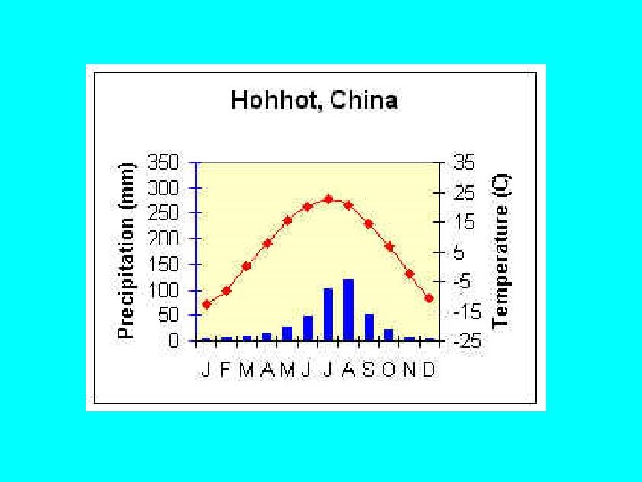
Climate graph (Climograph)- shows precipitation and temperature of a location bars = precipitation lines = temperature
Temperate- seasonal Northern Hemisphere- look at temperature line in J, J, A
Tropical, Southern Hemisphere
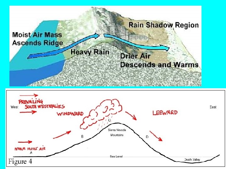
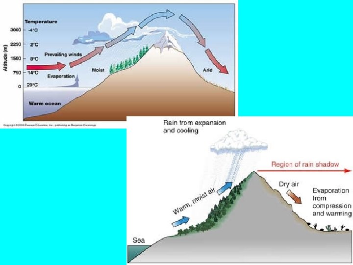
5 factors of climate 1) Latitude- distance from equator 2) Altitude- (mountain) 3) Global Winds- trade winds, prevailing westerlies, polar easterlies 4) Ocean currents- warm/cool climates 5) Nearness to center of continent or large body of water 1) Specific heat – inland v. coastal 2) Windward v. Leeward side of mountain
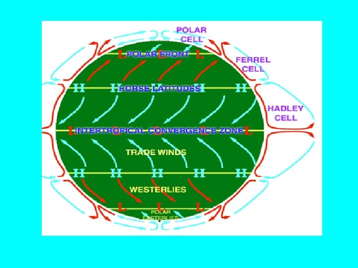
Important facts on Climate: • • Factors affecting climate include: ‣Latitude- The higher your latitude, the colder your climate. ‣Altitude- The higher your altitude, the colder your climate. ‣Mountain ranges- On the windward side of a mountain, your climate will be wet, on the leeward side of a mountain, your climate will be dry. ‣Oceans/Large Bodies of Water- The closer you are to water, the less extreme your climate (warmer winters and cooler summers). ‣Ocean Currents- Locations near warm water currents will have warmer climates, locations near cold water currents will have colder climates. ‣Planetary Wind Belts- On-shore winds will cause wet climates, offshore winds will cause dry climates (monsoon winds). 1) trade winds, prevailing westerlies, polar easterlies
OROGRAPHIC LIFTING • Occurs when there is a change in temperature of a gas caused by expansion or contraction of the gas WITHOUT the application or removal of heat. • ‣ Cooling: warm air ascends and expands. Expansion causes cooling (more space between molecules, less collisions between molecules). • ‣ Warming: cold air descends and is compressed by surrounding air. Compression causes warming (less space between molecules, more collisions between molecules). • ‣ Orographic lifting occurs when air is forced up by mountains, causing cooling, condensation, and precipitation on the windward side and warming and evaporation on the leeward side.
When air is forced to rise because it hits mountains, it will expand, cool, and condense - Windward side = a cool, moist climate. - Leeward side= a warm and dry climate
Which location is on the windward side? Leeward side?
What is the climate of Seattle? Spokane?
• Heating of Earth comes from Sun • This heating is UNEVEN • The uneven heating causes the air and ocean to MOVE • Because the earth is rotating, the motion CURVES
Coriolis Effect • The Coriolis force- affects the direction of wind flow due to earth’s rotation. • This force is what causes objects in the northern hemisphere to turn to the right and objects in the southern hemisphere to turn to the left.
Global Winds
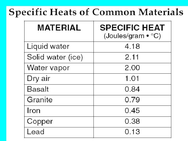
Specific heat • The ability to resist being heated – Low specific heat = heat up and cool down fast – High specific heat = heat up and cool down slowly
Sea Breeze- Day • Water has a high Air sinks over water and moves to landspecific heat= takes H to L longer to warm up and cool down • Air over water is cooler, so it sinks and a breeze moves from water to land
Land Breeze- Night • At night , the land will cool down faster than the water- the breeze then moves from land to sea
TAKE A LOOK AT ANOTHER TWO LOCATIONS AT NEARLY THE SAME LATITUDE Nations Online Project: http: //www. nationsonline. org/oneworld/usa_map. htm
INLAND/COASTAL LOCATIONS: Average Jan and July Temperatures Seattle: High 47 F , Low 37 F July: High 75 F, Low 55 Bismarck: High 23 F , Low 2 F July: High 84 F, Low 56 F Cooler winter, warmer winter, Warmer summer= cooler summer= coastal locations inland locations From Weather channel: www. weather. com
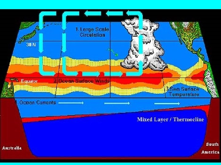
Oceanic currents are driven by global winds and differences in water density
Some of the currents are moving warm water – and some are moving cool water Cool- start near poles and move towards equator Warm- start near equator and move towards poles From http: //tornado. sfsu. edu/geosciences/classes/m 356/Ocean. Currents/Global_currents. jpg
LETS COMPARE TWO PLACES NEAR THE OCEAN Halifax, Nova Scotia • Latitude 44. 67 o N • Average Jan temp High 29 o. F Low 13 o. F London, England • Latitude 51. 5072° N • Average Jan Temp High 5 oo. F Low 41 o. F
http: //www. holiday-weather. com
Key points on factors of climate • Water modifies temperature- Coastal locations will have warmer winters and cooler summers • Greater temperature range inland • Water heats up and cools off much slower than land-high specific heat • Latitude determines wet and dry zones • Warm ocean currents start near the equator and travel away from equator
1. Which locations are on the windward side of a mountain? Why? 2. Which is on the leeward side? 3. Out of B and C, which is has a greater range of temperatures? Why?
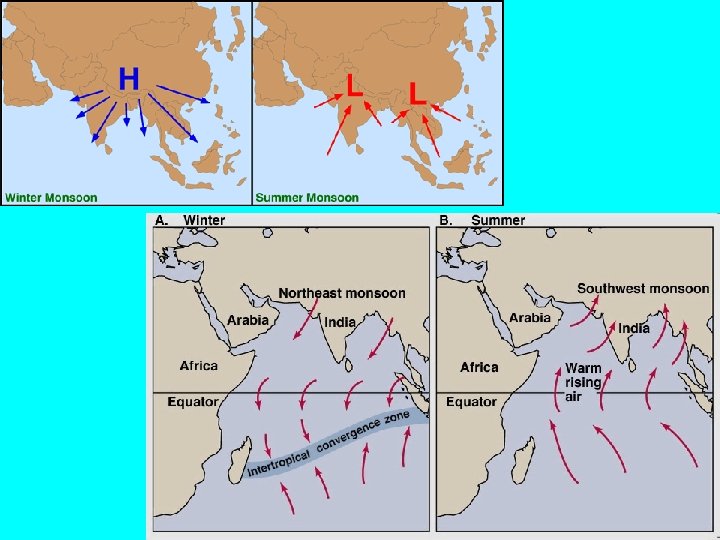
Monsoons • A monsoon is a seasonal change in the direction of the prevailing, or strongest, winds of a region. • Monsoons cause wet and dry seasons • Monsoons are most often associated with the Indian Ocean. • Monsoons always blow from cold to warm regions (H to L)
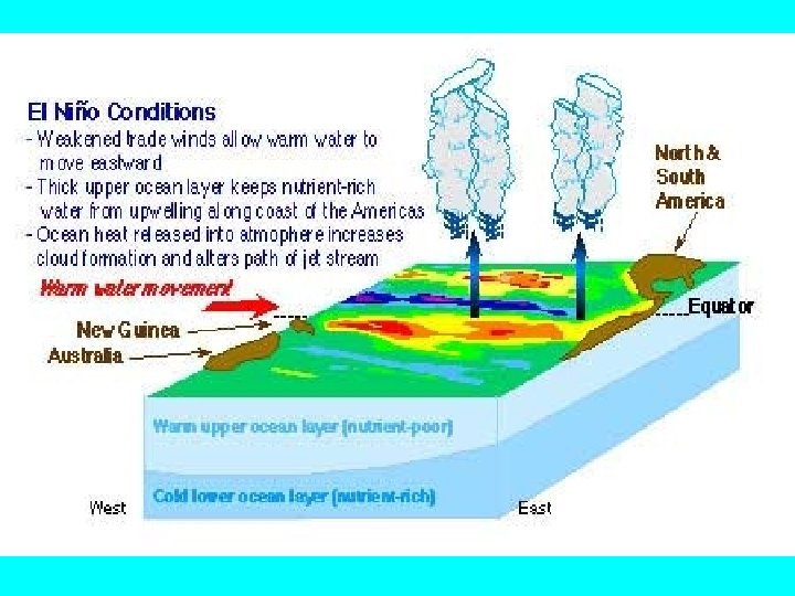
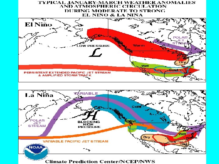
• http: //www. bom. gov. au/lam/Students_Teachers/elnanim/elani. shtml El Nino and La Nina • El Nino- Characterized by • La Nina- characterized unusually warm sea surface by unusually cold sea temperatures in the Pacific surface temperatures- Ocean- – wetter in West Pacific – drier weather in West Pacific, wetter in East Pacific and drier in East Pacific
Electromagnetic Energy • Insolation – incoming solar radiation – Direct- straight to earth’s surface – Diffuse- scattered or reflected by atmospheric elements (clouds) Infrared radiation • Electromagnetic radiation of a longer wavelength (red= heat)
Energy from the sun enters as shortwave radiation (visible, UV) and leaves as long-wave radiation (infrared)
Greenhouse effect • The natural heating of Earth’s surface by certain atmospheric gases • We could not live without the greenhouse effect • Greenhouse gases include: CO 2, water vapor, methane, and nitrous oxide • Any increase in these gases would cause an increase in absorbed radiation • This can lead to global warming! • Burning of fossil fuels, deforestation(cutting down trees), pollution causes global warming
Greenhouse effect
How is Carbon dioxide put into the atmosphere? When Do You Send Greenhouse Gases into the Air? Whenever you. . . Play a Video Game • Listen to a Stereo • Wash or Dry Clothes • Watch TV • Use a Dish • Use the Air Conditioner Washer • Turn on a Light • Microwave a • Use a Hair Dryer Meal • Ride in a Car
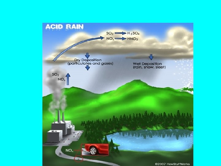
Acid Rain- result of sulfur and nitrogen oxides in the air -oxides travel with wind and when it precipitates, - it will be acid rain