Arc GIS Hydro Data Model Design principles for


 will be the standard for")


 •")


")


 • Boundaries for")


")

 and Elevation (z) Values on Cross Sections")
")


 http: //water. usgs. gov Web access to USGS water")


 • Improved accuracy of Next. Downstream Tool")


")

- Slides: 84
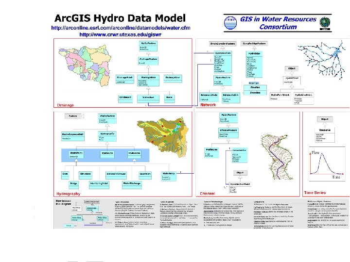
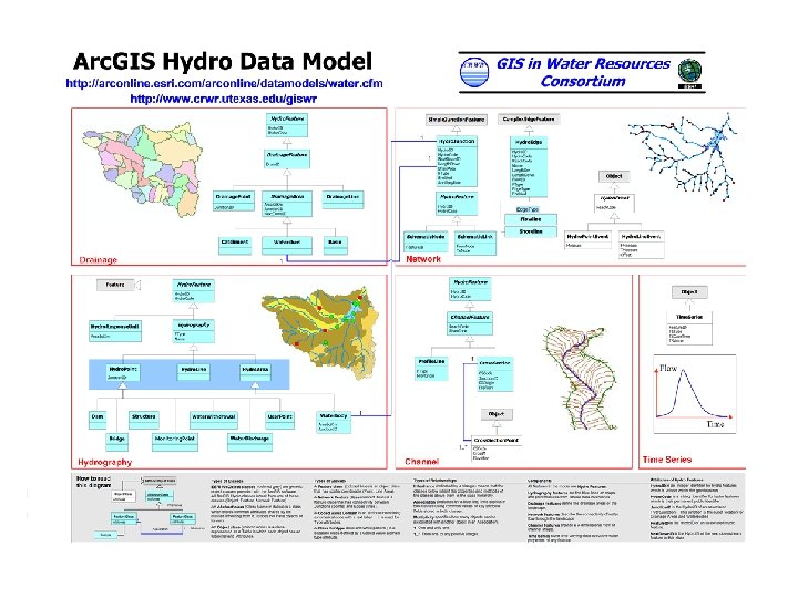
Arc. GIS Hydro Data Model • • Design principles for the data model Data model components Time series Arc Hydro tools
CRWR GIS in Water Resources Consortium GIS Water Resources Bringing together these two communities by using a common geospatial data model http: //www. crwr. utexas. edu/giswr
Trends During 1990’s • Standardized GIS data sets were produced for hydrology • Internet became a major conduit for data distribution • Most US hydrologic models had GIS interfaces constructed for them • Microsoft COM protocol became a standard (Word, Powerpoint, Excel, Visual Basic for Applications) • ESRI adopted COM for Arc. GIS
Trends during 2000’s • Relational databases (Access, Oracle, …) will be the standard for data storage • Geospatial and temporal data for hydrology will be more formally synthesized • Use of component technologies will blur the line between applications (hydrologyhydraulics-water quality) • Increasing use of real-time applications • More use of terrain surfaces e. g. LIDAR
Arc. GIS Data Models • Facilitate a process with the user community • Capture the essential, common data model for each discipline • Build a database design template that works well with Arc. GIS • Build on experience, not a standards exercise • Share the model on Arc. Online http: //arconline. esri. com/arconline/datamodels. cfm
Essential Data Model Organization B Organization A Something in common Organization D Organization C The data model for a business organization tends not to change greatly over time unless the business organization changes the fundamental way that it does business
Model Definition • Develop a data model to support Hydrology and Hydrography • Link the vector and raster worlds • Understand producer and consumer needs • Exercise with real data to validate the model • Use a geometric network for faster tracing and data quality validation
Evolution of the Model • Hands-on experience was key to evolution • We have somehow struggled through the process and found new ways of managing Hydro Data – – Consistent structure Varying detail Multi-purpose Common tools and techniques (Patterns) • You will hear interest and excitement about this in the presentations today
Acknowledgements Many people and organizations have contributed to the development of Arc Hydro. We thank you!! • CRWR – ESRI team • BYU, CDM, DHI, Dodson, EPA, HEC, LCRA, NHD, TNRCC, TWDB, USGS • Many individuals in academia, government and industry
Arc. GIS Hydro Data Model Hydrography Hydrology
Arc. GIS Hydro Data Model Drainage Network Flow Hydro. Features Time Series Hydrography Channel
Data Model Based on Inventory NHD Points NHD Lines NHD Areas Gages Dams Bridges Make an inventory of all features of a given type in the region What is it? Where is it?
Data Model Based on Behavior Follow a drop of water from where it falls on the land, to the stream, and all the way to the ocean.
Integrating Data Inventory using a Behavioral Model Relationships between objects linked by tracing path of water movement
Arc Hydro Implementation Workspace Geodatabase Feature Dataset Feature Class Geometric Network Relationship Object Class
Arc Hydro Design Principles • Classification – Partitioning, typing, and naming of classes • Attribution – Feature description, including time series • Association – Relating features using key attributes • Navigation – Following water movement from feature to feature
Classification • Partitioning – Like features are grouped into components (Network, Drainage, …) • Typing – Object, Feature, Network feature • Naming – Common names if possible, defined by a glossary
Classification Hierarchy Light Heavy 1. Text descriptor e. g. FType 2. Coded Value Domain e. g. FDir 3. Subtypes – separate classes with same attributes e. g. Hydro. Edge 4. Subclasses - separate classes with different attributes e. g. Hydro. Point • FType = “Stream/River” • 1 = “With. Digitized”, 2 =“Against. Digitized”, . . • Edge. Type = 1 for Flowline, = 2 for Shoreline • Dam, Bridge, Monitoring Point, …
Two-Way Classification: FTypes of Subtypes • Edge. Type = 1 Flow. Line • FType = – – – “Stream/River” “Canal/Ditch” “Pipeline” “Connector” “Waterbody Flow. Line” • Edge. Type = 2 Shoreline • FType = – “Bankline” – “Shoreline” – “Coastline”
Attribution • Minimal attribution in the model – Assume user will add more • Attribute Names are all 10 characters or less so they are not truncated when exported to Shapefiles • Standard conventions – ID is a long integer – Code is a string
Hydro Features • Every Arc Hydro feature is a Hydro Feature with a Hydro. ID and Hydro. Code • Hydro. ID = Class Number + Object. ID e. g. 12000013 is object 13 in class 12 (unique within a geodatabase) • Hydro. Code = Hydro. ID + Geodatabase name e. g. Mybasin 12000013 (unique within a set of geodatabases)
Association • An association is established using key fields in two separate tables – Can build relationship if necessary • Hydro Assocation – Hydro. ID of one class is an attribute of another class – Junction. ID (Drainage Outlets) – Feature. ID (Time Series) – Next. Down. ID (Downstream feature)
Navigation • Navigation means tracing the movement of water downstream or upstream – Dendritic Navigation – using Next. Down. ID within a single feature class – Network Navigation – using Network Analyst tracing tools on Hydro Network – Schematic Navigation – using Schematic. Link and Schematic. Nodes to connect features in several classes
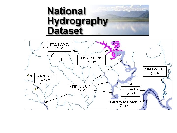
National Hydro Data Programs http: //www. crwr. utexas. edu/giswr/nhdconf/nationalhydro. html National Elevation Dataset (NED) National Hydrography Dataset (NHD) Elevation Derivatives for National Applications (EDNA) Watershed Boundary Dataset
How do we combine these data? Digital Elevation Models Watersheds Streams Waterbodies
An integrated raster-vector database
Where Does the Raindrop Go? Dale Honeycutt’s concept, May 2000
Water Flows from an Area to a Line Problems with this: • Areas and lines are not always consistent with one another. • Sometimes many lines within one area.
How to Connect Areas to the Hydro Network? Regardless of where the drop falls in the area, its runoff is on the network at the outlet point Areas connect to lines at points Outlet Points
Area to Stream Outlet Connectivity
Arc. Hydro and Arc. FM Water • Arc. FM Water – Water Infrastructure – Water distribution – Wastewater collection – Storm sewers • Arc Hydro – Natural water system – Catchments drain to storm sewer inlets – Storm sewers discharge to streams
Area to Sewer Inlet Connectivity
Schema • A schema is the structure or design of a database. • A schema specifies the feature and object classes -- including their attributes and relationships -- of the geodatabase.
Repository • A repository is database that contains the schema information needed to create a geodatabase from a UML model created using a CASE tool.
Arc. GIS Hydro Data Model • • Design principles for the data model Data model components Time series Arc Hydro tools
Arc Hydro Implementation Workspace Geodatabase Feature Dataset Feature Class Geometric Network Relationship Object Class
GIS in Water Resources Consortium Arc. GIS Hydro Data Model Network
Example - Holland
GIS in Water Resources Consortium Arc. GIS Hydro Data Model Hydrography
River networks for 8 -digit HUC watersheds
GIS in Water Resources Consortium Arc. GIS Hydro Data Model Hydrography
GIS in Water Resources Consortium Arc. GIS Hydro Data Model Drainage
Watersheds of the US 2 -digit water resource regions 8 -digit HUC watersheds
Watershed Hierarchy Digit # 2 4 6 8 HUC 10 12 EDNA Available In Progress
Watershed Boundary Dataset • National Program by USGS and USDA (NRCS) • Boundaries for 10 - and 12 - digit watersheds • First cut is by automated delineation from NED • Hand checked and edited 10 -digit watersheds
Elevation Derivatives for National Applications (EDNA • National program by USGS and NWS • 5000 cell threshold on a 30 m DEM (~ 8 km 2 average drainage area) • ~ 1 million catchments for US when completed • Includes grid derived products e. g. topmodel index
Area to Area Connectivity: Schematic. Links built using Next. Down. ID
GIS in Water Resources Consortium Arc. GIS Hydro Data Model Channel
Pecan Bayou: Flood Hydrology and Hydraulics Study by David Anderson (CRWR)
Pecan Bayou: Data Development Process Hydrology & Hydraulics HEC-RAS CRWRPre. Pro Terrain Model Floodplain Terrain Model David Anderson, 2000 HECHMS HECGeo. RAS
3 -D Polyline Z Measure (m) and Elevation (z) Values on Cross Sections
Channel Geometry using Arc Scene Begin with Contours Build a Triangulated Irregular Network (TIN) Extract Profile. Lines and Cross. Sections Demo
Arc. GIS Hydro Data Model • • Design principles for the data model Data model components Time series Arc Hydro tools
Time Series Objectives • Store Metadata about each collection of time series values – What is measured – What units are used • Display and store Time Series Views – Rainfall for Gage 1001010 – All data between years 2000 and 2001
Time Series Classes
Time. Series Attributes • • • Feature. ID – ID of spatial feature TSType. ID – Identifies TS properties TSDate. Time - Timestamp TSValue - Value TSDesc – Property of particular record
Time. Series Example
TSType. Info Attributes • • TSType. ID – Identifies a set of TS properties Variable – What is being measured or recorded Units – The units that the data values are in Is. Regular – Values spaced at regular or irregular time intervals • TSInterval – Time interval between values (if regular) • Data. Type – The type of time series data • Origin – Values recorded or generated
More on Date. Type • • • Inst-Value Inst-Cumulative Step-Average Step-Maximum Step-Minimum
TSType. Info Example
Time Series Views • Use Query Builder in Arc. GIS – Save – Load • Provides Selective Views of Entire TS Table • Requires no extra functionality
Connecting to Time Series Flow Drainage. Point Hydro. ID Junction Feature. ID Time. Series Hydro. Point Cross. Section Feature. ID of time series is Hydro. ID of feature the time series describes
National Water Information System (NWIS) http: //water. usgs. gov Web access to USGS water resources data in real time
Arc. GIS Hydro Data Model • • Design principles for the data model Data model components Time series Arc Hydro tools
Arc Hydro Tools • Code development being done jointly by ESRI and CRWR • Uses a standardized application framework for VB tools in Arc. GIS • Fills in standard attributes in Arc Hydro data model • Will be published on GISWR web page and freely available
Application Framework • Tool for developers • Eases routine Arc. GIS programming tasks • Provides standard look and feel to applications
Anatomy of Code
Streamlining Routine Tasks Vs.
User-Interface Capabilities • Handles Basic Input/Output • Reduces development time by up to 50% • Provides a standard look and feel across different applications
Tool Updates • “Repaired” NWIS tool (released) • Improved accuracy of Next. Downstream Tool (development) • Added “Shortest Path to Sink” algorithm to Length. Downstream tool (development) • Exercise on Arc. Hydro. Lite being presented in class next week.
Overview • • • Introduction Conceptual Framework Subtyping of Time series Properties of Time series class Applications
Arc Hydro NWIS Application • Custom Tool Retrieves NWIS Data • Time Series Table Built Automatically • Operates Within Arc. Map GUI Demo
Arc. GIS Hydro Data Model Drainage Network Flow Hydro. Features Time Series Hydrography Channel
Open Architecture for Water Modeling Interface 1 Arc. GIS Temporal Data Geospatial data Interface 4 Custom Designed Interface 2 Excel Process Engines Interface 3 Hydrologic Model
Arc. GIS Interface to Model Lib. Hydro: An HEC-1 subroutine library converted to a. dll Interface written using VBA for Arc. GIS
Excel Interface to Model Interface constructed using VBA for Excel
Hydrologic Model Hydrologic model constructed using with a Visual Basic interface calls Arc. Objects to access Arc Hydro data
Custom Interface e. g. Basins
Custom Interface (for several hydrologic models)
TIWSS Texas Integrated Water Simulation System WRAP Water Availability SWAT Water Quality Arc Hydro Geospatial and Temporal Data HEC Models Flooding & Water Management Modflow Groundwater