Woodbridge Cruising Club Navigation Refresher 2019 Pilotage Navigation

Woodbridge Cruising Club Navigation Refresher 2019

Pilotage & Navigation • Pilotage: The art of getting lost in sight of land. • Navigation: The distinct and far more complex science used to get lost in offshore waters.

Topics to be Covered • • Lights, Shapes Weather Chart Plotters, AIS v Radar Tidal Streams and Tidal Heights. EPs GPS tips DSC VHF Reminder MOB

QUICK QUIZ

SHAPES - 2 Vessel motor sailing Rule 25 e Fog signal At intervals not exceeding 2 mins If making way If stopped

SHAPES - 4 Power driven vessel restricted in ability to manoeuvre Fog signal At intervals not exceeding 2 mins Rule 27
")
SHAPES - 8 Vessel engaged in underwater operations, (restricted in her ability to manoeuvre) Rule 27 d Obstruction on the starboard side, clear to port side. Fog signal At intervals not exceeding 2 mins

SHAPES - 10 Vessel not under command Fog signal At intervals not exceeding 2 mins Rule 27

LIGHTS -20 Starboard aspect Pilot vessel on duty, under way. Fog signal 1 long blast at intervals not exceeding 2 mins May also sound 4 short blasts RULE 29

LIGHTS - 15 Starboard aspect Power driven vessel restricted in ability to manoeuvre (probably over 50 m) RULE 27 Fog signal 1 long & 2 short blasts at intervals not exceeding 2 mins

LIGHTS - 13 Port aspect Power driven vessel towing. Tug under 50 m. Restricted in ability to manoeuvre. Tow >200 m. RULE 24 & 27 Fog signal 1 long & 2 short blasts - intervals not exceeding 2 mins followed by 1 long & 3 short blasts from towed vessel, or last in tow

LIGHTS - 21 Starboard aspect Power driven vessel constrained by draught probably over 50 m. Under way. RULE 23&28 Fog signal 1 long & 2 short blasts at intervals not exceeding 2 mins

LIGHTS - 23 Port aspect Vessel not under command Making way. RULE 27 Fog signal 1 long & 2 short blasts at intervals not exceeding 2 mins

LIGHTS - 18 Aspect unknown Vessel engaged in underwater operations, Not making way. obstruction on the red side, clear to pass on the green side. Fog signal 1 long & 2 short blasts at intervals not exceeding 2 mins RULE 27

LIGHTS - 29 Aspect unknown Fishing vessel other than trawler. Not making way RULE 26 c Fog signal 1 long & 2 short blasts at intervals not exceeding 2 mins. © ROYAL YACHTING ASSOCIATION 2000 Slide 15

Rules of the road Who gives way wind Yachtsailing Two B on port vessels tack onmust opposite give tacks way to the yacht on starboard tack B © ROYAL YACHTING ASSOCIATION 2000 A Slide 16

Rules of the road Who gives way wind Windward Yachts on the yacht same A gives tack way to the leeward yacht A B © ROYAL YACHTING ASSOCIATION 2000 Slide 17

Rules of the road Who gives way wind Two vessels Both A and B under turn power to starboard A © ROYAL YACHTING ASSOCIATION 2000 B Slide 18

Manoeuvring signals Sound Signals Turning starboard One short Two Operating Three short toblasts engines port blasts astern © ROYAL YACHTING ASSOCIATION 2000 Slide 19

Warning signal Sound Signals Five or more Unsure of your rapid intentions short blasts © ROYAL YACHTING ASSOCIATION 2000 Slide 20

Fog signals Sound Signals One long blastvessel making way in Power driven restricted visibility © ROYAL YACHTING ASSOCIATION 2000 Slide 21

Fog signals Sound Signals Two long blasts Power driven vessel not making way in restricted visibility © ROYAL YACHTING ASSOCIATION 2000 Slide 22

Fog signals Sound Signals One long and in two short blasts Vessel sailing restricted visibility © ROYAL YACHTING ASSOCIATION 2000 Slide 23

Fog signals Sound Signals One longvessel and two short blasts Fishing in restricted visibility © ROYAL YACHTING ASSOCIATION 2000 Slide 24

WEATHER

EFFECT OF SURFACE FRICTION Gradient or 'Weather Map' Wind 30º Initial direction Backed wind (Anticlockwise) 15º Veered wind (Clockwise) Friction backs gradient wind by about 30 degrees over land 15 degrees over sea © ROYAL YACHTING ASSOCIATION 2000 Slide 26

COMBINED WIND EFFECTS Wind Aloft Land Sea Winds Diverge Light Wind © ROYAL YACHTING ASSOCIATION 2000 Strong Wind Sea and Land Winds Converge Slide 27

BUYS BALLOT'S LAW 992 1000 1008 1024 1016 Low Pressure 1032 High Pressure Buys Ballot's Law In the Northern Hemisphere, if you stand with your back to the wind, the LOW PRESSURE area is to your left © ROYAL YACHTING ASSOCIATION 2000 H L Slide 28

VISIBILITY CRITERIA Good More than 5 miles Moderate 5 to 2 miles Poor 2 miles to 1000 metres Fog Less than 1000 metres Dense fog Mist or Haze © ROYAL YACHTING ASSOCIATION 2000 1000 to 2000 metres Slide 29

PRESSURE AND TENDENCY Tendency = Change in 3 Hours © Steady Less than 1 mb Slowly Less than 3 mb Quickly 3. 5 to 6 mb Very Rapidly Rising More than 6 mb Higher Falling Lower ROYAL YACHTING ASSOCIATION 2000 Slide 30

USE OF WEATHER FORECASTS Determine weather for the day Determine where the best shelter is: Imminent – within 6 hours from forecast Soon - 6 to 12 hours from forecast Later – over 12 hours from forecast Decide when to sail Decide whether it is prudent to: Sail Stay at anchor Run for shelter © ROYAL YACHTING ASSOCIATION 2000 Slide 31

Plotters ETC © ROYAL YACHTING ASSOCIATION 2000 Slide 32

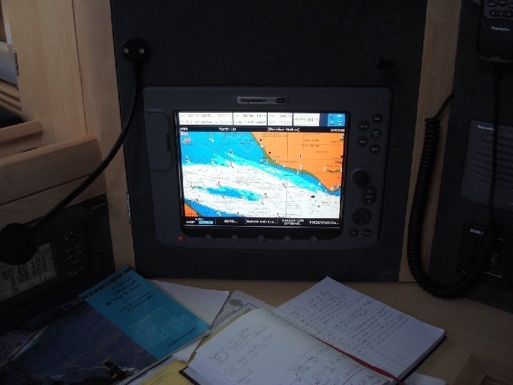
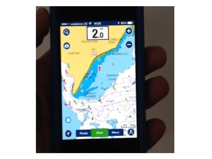
Chart Plotters, Tablets & Smart Phones • “Chart Plotters” have transformed life for the cruising sailor. – Plotter with AIS overlay makes amazing package – AIS is NOT a radar substitute – BUT! • On a budget it’s the one to go for. – Short handed sailing much easier with a plotter. • Record your Track on leaving the Deben - return in poor vis then simple just follow your track. – Navionics on a Smart Phone. £ 34. – Plotters tend to make us all LAZY about log keeping and plotting on a chart. – Do they make us Over-confident?

Pencil & Charts • Why bother with conventional navigation? – If our electronics fail its all we have! - e. g. Lightning Strike! (EMP) – It is still “Good practice”. • Not quite into paperless sailing yet? – It can be very satisfying. – If we don’t use it we lose it! – Extra interest on a long passage?

TIDAL STREAMS

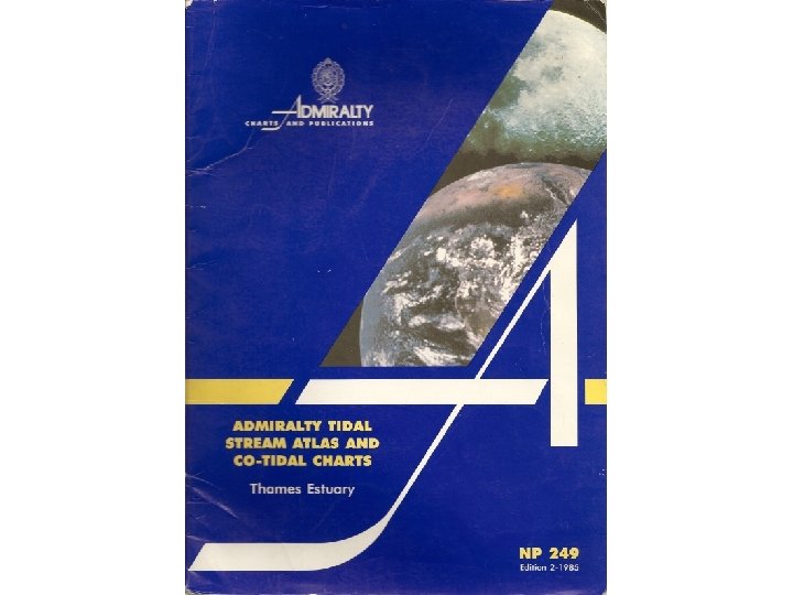
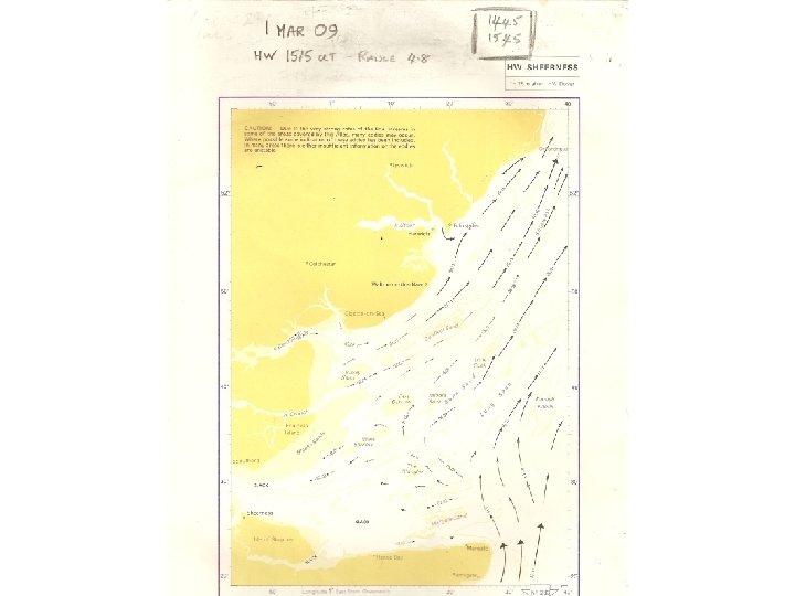
Tidal Streams • Getting the tide right is ESSENTIAL. • Tidal Atlas NP 249 & NP 251 for local use • Reeve -Fowkes an alternative if you prefer. – Tide rates only accurate if used properly – WITH • Computation of Rates table. – Instant view of direction throughout the day. – Tidal Diamonds never where you want them. • Data box never on the part of chart you need • Small and not easy to read in poor light – Beware different REFERENCE Ports! • NP 251 Dover – NP 249 Sheerness
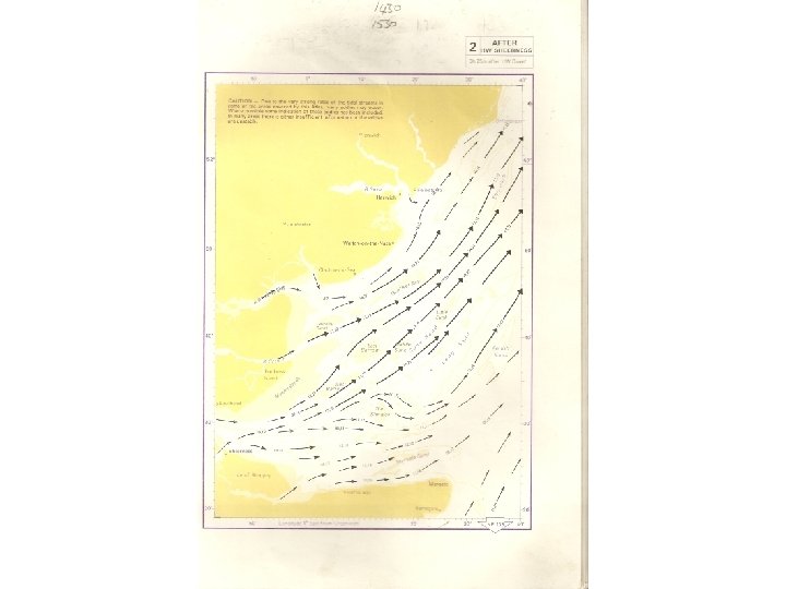

TIDAL STREAM ATLAS Stream 03, 05 Slack Rate of stream 0. 3 kn at Neaps 0. 5 kn at Springs Rate of stream 12, 23 1. 2 kn at Neaps 2. 3 kn at Springs
 Springs 2. 9 kn")
TIDAL DIAMONDS 3 hours before HW Stream setting towards 318(T) Springs 2. 9 kn Neaps 1. 5 kn

HOURS RELATED TO HIGH WATER Time of High Water = 1200 HW - 2½ hrs 0930 HW - 1½ hrs 1030 HW - ½ hr 1130 HW - 2 HW - 1 HW HW 1200 HW + 1 HW + ½ hr 1230 HW + 2 HW + 1½ hrs 1330 HW + 2½ hrs 1430

TIDES • To make getting the correct tidal hour easier – Half an hour before & half an hour after • Look up the tide then adjust it to: – On the hour – 15 min past – Half past – 45 min past • Never more than 7 min out. • Mark up Atlas with your watch time.
")
Mean Range PLYMOUTH COMPUTATION OF RATES TIDAL STREAM RATE (in tenths of a knot) 6 m 10 20 30 40 50 60 70 5 m Springs 4 m 3 m Neaps 2 m 1 m Tenths of a Knot 10 20 30 40 50 60 70
")
Mean Range PLYMOUTH COMPUTATION OF RATES TIDAL STREAM RATE (in tenths of a knot) 6 m 10 20 30 40 50 60 70 5 m Springs 4 m Rate of stream at Neaps = 2. 3 knots (from tidal stream atlas or diamonds) 3 m Neaps 2 m 1 m Tenths of a Knot 10 20 30 40 50 60 70
")
COMPUTATION OF RATES Mean Range PLYMOUTH TIDAL STREAM RATE (in tenths of a knot) 6 m 10 20 30 40 50 60 70 5 m Springs 4 m 3 m Rate of stream at Springs = 4. 6 knots (from tidal stream atlas or diamonds) Neaps 2 m 1 m Tenths of a Knot 10 20 30 40 50 60 70
")
Mean Range PLYMOUTH COMPUTATION OF RATES TIDAL STREAM RATE (in tenths of a knot) 6 m 10 20 30 40 50 60 70 5 m Springs 4 m 3 m Neaps 2 m 1 m Tenths of a Knot 10 20 30 40 50 60 70
")
Mean Range PLYMOUTH COMPUTATION OF RATES TIDAL STREAM RATE (in tenths of a knot) 6 m 10 20 30 40 50 60 70 5 m Springs Today’s Range 4. 2 m 4 m Rate = 4. 1 knots 3 m Neaps 2 m 1 m Tenths of a Knot 10 20 30 40 50 60 70
")
Mean Range PLYMOUTH COMPUTATION OF RATES TIDAL STREAM RATE (in tenths of a knot) 6 m 10 20 30 40 50 60 70 5 m Springs 4 m Springs Today’s Range 5. 4 m Rate = 5. 2 knots 3 m Neaps 2 m 1 m Tenths of a Knot 10 20 30 40 50 60 70

Tidal Heights • Unlike Tidal streams which use Reference Ports for a wide area, tidal heights are specific to where you are or where you are going. – Secondary Port conversions are essential. – Time difference can be done by mental calculation – More care sometimes needed with height differences • Time Zone -0100 – The near Continent Beware!

Tidal Theory Tidal terms Charted Depth Neap Mean Spring Highest Clearances Height Tidal terms range datum High Low of range ofastronomical depth water tide light Water Springs Neaps Springs tide Height of light (above MHWS) Clearance of bridge (above HAT) HAT MHWN Neap range Height of tide Depth of water MLWN Charted depth (below CD) MHWS Spring range MLWS Chart datum

Rule of Twelfths • Can provide approx heights of tide between HW & LW • Rise and fall at place concerned must follow a regular sine wave pattern. Does not work where there are double HWs, Stands ETC (Solent). • Tide assumed to rise and fall at a predicted height calculated as twelfths of the tidal range – – – First Hour from HW tide falls Second Hour it falls an additional Third Hour it falls an additional Fourth Hour it falls an additional Fifth Hour it falls an additional Sixth Hour it falls an additional 1 twelfth of the range 2 twelfths 3 twelfths 2 twelfths 1 twelfth

Rule of Twelfths • Range 3 m so 1 twelfth = 25 cm – 1 st hour of fall tide drops by 25 cm (1/12 th) – 2 nd hour tide falls by a further 50 cm (2/12 ths ) – 3 rd hour tide falls by a further 75 cm (3/12 ths ) Half tide is what it says: half of 3 m = 1. 5 m - 4 th hour tide falls by a further 75 cm (3/12 ths ) - 5 th hour tide falls by a further 50 cm (2/12 ths ) - 6 th hour tide falls by a further 25 cm (1/12 th )

TIDAL CURVE

TIDAL CURVE Height of tide at 1415 = 2. 9 m Draw perpendicular to HW line 1415 1515 1615 1715 1815

SECONDARY PORTS - TIMES & HEIGHTS

TIDES • Accurate Tidal Streams – Should give you The fastest & most efficient passage • Accurate Tidal Heights – Should give you Safe entry/exit over sills/bars etc. At anchor – a good nights sleep.

EPs • A good navigator is never lost, but his radius of uncertainty can be enormous. • Even if you only log your Lat & Long every couple of hours on passage if your GPS/Plotter fails you will not be lost – just work out your EP. • Do not rely on your plotter auto log, pencil in the log book best! • Try a Projected EP – to see your COG can be an eye opener!!

Magnetic Variation 2019 • The Compass rose on all charts gives the variation at a given date and the rate of change. • Our Nearest Compass Rose off Felixstowe gave Var as 1 degree W in 2012 decreasing by 8 minutes East annually. • 7 years at 8 min = 56 min. • Thus Variation locally in 2019 is ZERO.
 DR Deduced from Log and Compass Fix 0800 25. 1 M")
ESTIMATED POSITION (EP) DR Deduced from Log and Compass Fix 0800 25. 1 M Distance Run 6. 2 M er Wat T) 0°( 7 0 k Trac + DR 0900 31. 3 M
 DR Deduced from Log and Compass Fix 0800 25. 1 M")
ESTIMATED POSITION (EP) DR Deduced from Log and Compass Fix 0800 25. 1 M Distance Run 6. 2 M er Wat T) 0°( 7 0 k Trac + DR 0900 31. 3 M Tidal Stream . Estimated Position (No leeway) 0900 31. 3 M
 DR Deduced from Log and Compass Fix 0800 25. 1 M")
ESTIMATED POSITION (EP) DR Deduced from Log and Compass Fix 0800 25. 1 M Distance Run 6. 2 M (T) ° 0 7 k 0 c a r er T t a W + DR 0900 31. 3 M Tidal Stream . Ground Track 090° (T) Speed over ground 7. 2 kn Estimated Position (No leeway) 0900 31. 3 M
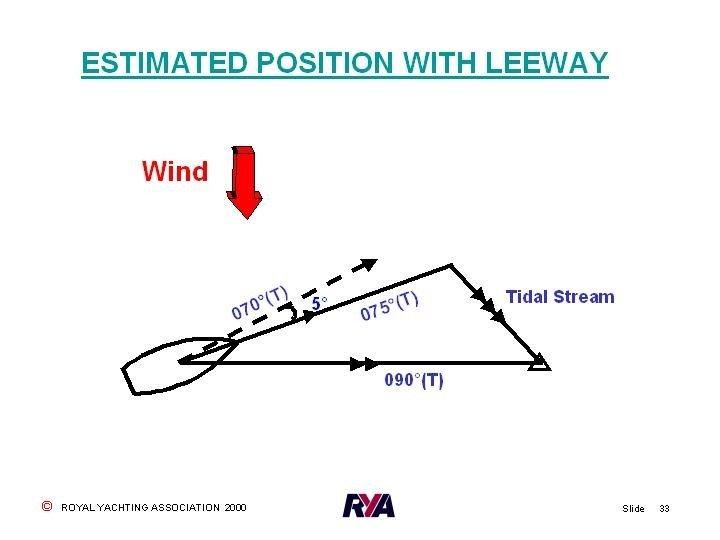
 ° 0 e 07 d e t t lo P t")
LEEWAY Wind (T) ° 0 e 07 d e t t lo P t o N s r u Co Water Track 075°(T) Course Plotted Leeway 5° Water Track = Heading + or - LEEWAY

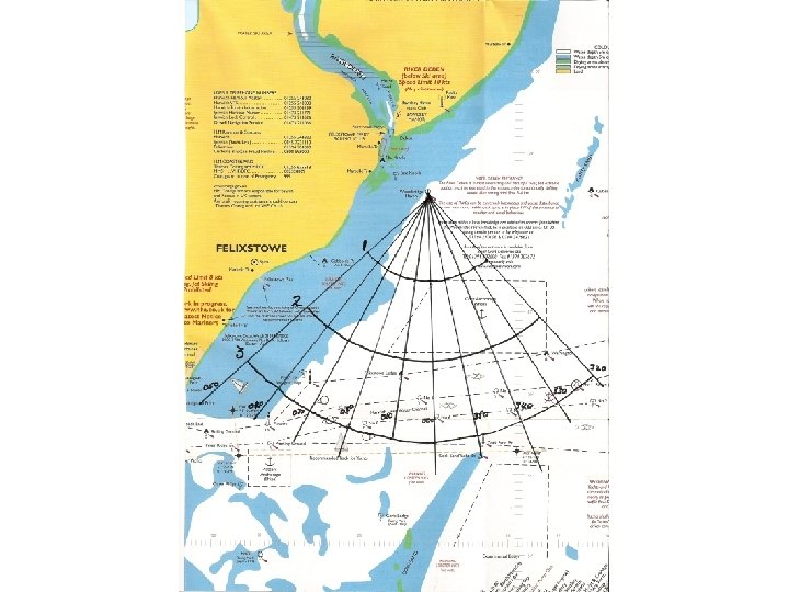
BASIC GPS • Waypoint web – simple, easy and great for hand held GPS sets and if short handed. • Locally it can be prepared in advance • Your local chart can be drawn up for the season. • More than one web can be drawn • Small open yacht? use a waterproof map case.

VHF RADIOS

CERTIFICATES & LICENCES l Your Yacht MUST Have: l Ship’s Radio Licence – Free and done online. – From Radiocommunications Agency- Ofcom – Validation Doc must be carried on board. l Call-sign and MMSI allocated with Licence. l You MUST Have l Authority to Operate a VHF Radio is the: l Short Range Certificate.

DSC Portables • A DSC portable requires a separate licence as it’s the equipment and not the ship being licenced. • They cannot be used for DSC calls anywhere in Continental Europe. • MMSI would be 2359 ---- • Cannot be given an ATIS Number

MMSIs • • First Digits 00 – Coastguard or Coast Station First Digits 02 - UK Group Ship identity First Digits 232, 233, 234, 235 - UK Ship Country code plus 9 – 2359 –Portable radio eg. Dover Coastguard 002320010 eg. UK Yacht/Ship 235000878 eg. Woodbridge Cruising Club 023200009
 and say slowly and clearly")
DISTRESS - Procedure l Press TX Button (PTT switch) and say slowly and clearly l MAYDAY, MAYDAY – This is Yacht Rapana, Yacht Rapana – *GZCM 7* MMSI 235123456…. . . MAYDAY. – This is Yacht Rapana – My position is - Lat & Long or TRUE bearing and distance FROM a known point. Do not guess if you don’t know where you are. – *International callsign* A recent addition.

DISTRESS - Procedure – I am - sinking, on fire etc. – I have …. number of persons on board - any other useful information. – I require IMMEDIATE assistance. – OVER - Release the PTT switch. l Keep listening on Ch 16 if possible, repeat the distress call if no acknowledgement heard.

VHF CHANNELS Calling and Distress 16 Digital Selective Calling Intership 70 6 8 72 77 Bridge to Bridge (Navigational safety) Small Craft Safety – UK only 67 UK Marinas 80 Yacht Club Safety Boats Race Control M 2 37 or M 13

UK Coastguard • National Maritime Opertions Centre – Located at Fareham plus: • 10 Coast Guard Operations Centres – Located around the coast. (Humber & Dover) • Changes transparent to users – i. e If you call Thames your call answered from Dover. Etc – Existing MMSIs & Tel Nos still OK

CG 66 • The CG 66 was replaced by RYA Safe. Trx in July last year (2018) CG 66 will lapse completely next year. • The new system is an APP for android and i. Phones. Or register on line: https: //safetrx. rya. org. uk/login. html • Simple to use. • It records all you yacht data like the CG 66 and can track you on passage.

SAILING ABROAD • Ships Papers? – – – Insurance SSR Bill of Sale/VAT receipt Radio Licence validation Document Red Diesel? Receipts? Schengen forms. • Personal Qualifications? • ICC - CEVNI • VHF SRC Old Restricted VHF Certificate of Competence no longer valid. • EHIC (European Health Insurance Card). • Q Flag? ? In date Flares, Liferaft!

CROSSING A TSS n Remember that it is your HEADING that should be a right angles to the TSS

SAFETY • LIFE JACKETS – USELESS unless worn • Is yours fit for purpose and fully serviceable? – When did you last check it – How do you check it? – An Annual Check? • Safety lines and jack stays – When did you last check yours?

MOB • A MOB is a Distress Situation – MAYDAY • Make a DSC Distress Alert before attempting recovery. • If Recovery successful Distress can be downgraded. • If not successful TIME is critical.

MOB- The CRASH STOP • Most modern yachts Heave-to badly • Crash stop simple – no skill required – Put Tiller to Boom or turn wheel to wind. – Pull in the mainsheet. – Yacht will turn in a tight circle. – Man in water will appear behind the yacht – Throw Danbuoy etc at this point. – Lock Tiller/wheel make a MAYDAY call – Start engine. Roll Genoa go downwind then motor back head to wind to MOB.

MOB • • If you have an engine you MUST use it. If calm recover from stern! Attach casualty by any means! Most cruising yachts sailed by just 2 people – Sailing school method– pointing, shouting etc often not applicable. – Reach Tack Reach in extremis only with no engine, requires considerable skill & practice.
- Slides: 84