IFR Flight Considerations IFR Flight Planning Flight Overview


 For a flight")
")

 Information")
 IFR")
 IFR alternate airport weather minima. – Unless otherwise authorized by the Administrator,")


 • Information is disseminated for all navigational facilities that are part of")
 • Taxi way closures, personnel and equipment near or crossing runways, and")


 Operation of")

 In")


 – File a “Preferred Route”")


- Slides: 50
IFR Flight Considerations IFR Flight Planning
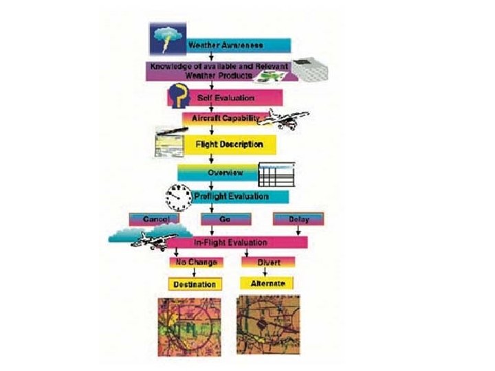
Flight Overview • AIM: 5 -1 -1 to 5 -1 -13 • Before planning the flight details… take a broad look at your objective. Compare: –Distance with fuel –Weather with route –Terrain with aircraft performance –Goal and your proficiency –Is this trip really necessary?
• § 91. 103 Preflight action. – Each pilot in command shall, before beginning a flight, become familiar with all available information concerning that flight. This information must include – • (a) For a flight under IFR or a flight not in the vicinity of an airport, weather reports and forecasts, fuel requirements, alternatives available if the planned flight cannot be completed, and any known traffic delays of which the pilot in command has been advised by ATC; • (b) For any flight, runway lengths at airports of intended use, and the following takeoff and landing distance information: • “NW KRAFT”
14 CFR 91. 103 • Preflight Action: NW KRAFT • (a) For a flight under IFR, pilot should know: • • N- Notams (all available info concerning flight) W- weather reports and forecasts K - known traffic delays R –runway lengths A- alternatives available F -fuel requirements T –Take Off/Landing Distance info, Section (b)
• § 91. 167 Fuel requirements for flight in IFR conditions • (a) No person may operate a civil aircraft in IFR conditions unless it carries enough fuel (considering weather reports and forecasts and weather conditions) to – . – (1) Complete the flight to the first airport of intended landing; – (2) Except as provided in paragraph (b) of this section, fly from that airport to the alternate airport; and – (3) Fly after that for 45 minutes at normal cruising speed. • (b) Paragraph (a)(2) of this section does not apply if: – (1) Part 97 of this chapter prescribes a standard instrument approach procedure to, or a special instrument approach procedure has been issued by the administrator to the operator for, the first airport of intended landing; and – (2) Appropriate weather reports or weather forecasts, or a combination of them, indicate the following: • (i) For at least 1 hour before and for 1 hour after the estimated time of arrival, the ceiling will be at least 2, 000 feet above the airport elevation and the visibility will be at least 3 statute miles.
14 CFR 91. 167 • Fuel Requirements for Flight in IFR Conditions: – to first airport of intended landing – to alternate airport (if required) – 45 minutes at normal cruising speed • Alternate is NOT needed when: – first airport has IAP AND – 1 - 2 - 3 rule forecast wx – +/-1 hour ETA – At least 2, 000’ceiling – At least 3 SM visibility
• § 91. 169 IFR flight plan: Information required. . – (a) Information required. Unless otherwise authorized by ATC, each person filing an IFR flight plan must include in it the following information: • (1) Information required under § 91. 153 (a) of this part; • (2) Except as provided in paragraph (b) of this section, an alternate airport. – (b) Paragraph (a)(2) of this section does not apply if : • (1) Part 97 of this chapter prescribes a standard instrument approach procedure to, or a special instrument approach procedure has been issued by the Administrator to the operator for, the first airport of intended landing; and • (2) Appropriate weather reports or weather forecasts, or a combination of them, indicate the following: – (i) For aircraft other than helicopters. For at least 1 hour before and for 1 hour after the estimated time of arrival, the ceiling will be at least 2, 000 feet above the airport elevation and the visibility will be at least 3 statute miles.
14 CFR 91. 169 • IFR Flight Plan: Information Required • Section (c) IFR alternate airport standard minimums WITH – 600’ ceiling / 2 sm for precision IAP – 800’ ceiling / 2 sm for nonprecision – at ETA at alternate NO IAP: • forecast WX must allow descent from MEA to airport under basic VFR – (check VFR minimums for all airspace you will transit!)
– (c) IFR alternate airport weather minima. – Unless otherwise authorized by the Administrator, no person may include an alternate airport in an IFR flight plan unless appropriate weather reports or weather forecasts, or a combination of them, indicate that, at the estimated time of arrival at the alternate airport, the ceiling and visibility at that airport will be at or above the following weather minima: • (1) If an instrument approach procedure has been published in part 97 of this chapter, or a special instrument approach procedure has been issued by the Administrator to the operator, for that airport, the following minima: – (i) For aircraft other than helicopters: The alternate airport minima specified in that procedure, or if none are specified the following standard approach minima: » (A) For a precision approach procedure. Ceiling 600 feet and visibility 2 statute miles. » (B) For a nonprecision approach procedure. Ceiling 800 feet and visibility 2 statute miles. • (2) If no instrument approach procedure has been published in part 97 of this chapter and no special instrument approach procedure has been issued by the Administrator to the operator, for the alternate airport, the ceiling and visibility minima are those allowing descent from the MEA, approach, and landing under basic VFR. .
• § 91. 173 ATC clearance and flight plan required. –No person may operate an aircraft in controlled airspace under IFR unless that person has – • (a) Filed an IFR flight plan; and • (b) Received an appropriate ATC clearance.
Route • Route Selection: – Aircraft Performance – Fuel Economy – Availability of Route Alternatives – Terrain – Aircraft Equipment (IFR-certified GPS) – Preferred IFR routes • AirportFacility Directory • Enroute section of Jeppesen Airway Manual – If starting with a fix, then expect routing by way of ODP/SID, or radar vectors.
• § 91. 181 Course to be flown. – Unless otherwise authorized by ATC, no person may operate an aircraft within controlled airspace under IFR except as follows: • (a) On a federal airway, along the centerline of that airway. • (b) On any other route, along the direct course between the navigation aids or fixes defining the route.
Along the Route • Check MEAs • Generally along airways unless GPS is IFR certified • Check for ODPs/SIDs and STARs • Alternate airports? – Far enough away to avoid destination’s adverse weather… close enough to make it. – Recommended instrument approach
Flight Information Publications • Flight Publications – Published Departures and Approaches • Suitability and familiarity – Alternate suitability • NOTAMs – Chart NOTAMs section of Jepps – Notices to Airmen • Airplane’s Flight Manual Supplement – IFR equipment certification requirements
NOTAM (D) • Information is disseminated for all navigational facilities that are part of the NAS, all public use airports, seaplane bases, and heliports listed in the A/FD. The complete list of all (D) information is maintained in a computer database. May be obtained from FSS for the duration of the (D) unless it is published.
NOTAM (L) • Taxi way closures, personnel and equipment near or crossing runways, and airport lighting aids that do not affect instrument approach criteria, such as VASI. • Distributed locally only and is not attached to the hourly weather reports. A separate file of (L) is maintained at each FSS for facilities in their area only.
FDC NOTAMs • Amendments to published IAPs and other current aeronautical charts. They are also used to advertise temporary flight restrictions caused by such things as natural disasters or large-scale public events that may generate a congestion of air traffic over a site. • FSS will give the pilot those FDC NOTAMs, that are within 400 miles of their facility and are unpublished. Those outside 400 miles are given if specifically requested by the pilot.
NOTAMS • An integral part of the NOTAM system is the Notices to Airmen Publication published every four weeks. – Once published, these NOTAMs are not given to pilots in weather briefings unless specifically requested by the pilot. – --- “Remember to ask for published NOTAMS ” ---
Flight Information Publications • AIM – For review of current procedures and changes • Navigation Log – Have a flow • Aircraft logbooks – For transponder, pitot/static, altimeter, and VOR check currency • Use Latest Issue of Aeronautical Charts – IFR Enroute Charts: 56 days – IFR Approach Charts: 56 day cycle
Weather Considerations By the time you are ready to receive a standard briefing from Flight Service, you should already have some idea about the weather hazards along your route of flight and conditions at your destination.
Pre-Flight Briefing • Pre-flight Briefing Objective: “… communicate a “picture” of meteorological and aeronautical information necessary for the conduct of a safe and efficient flight. ” • Preflight Briefing request should include… – – – Type of flight planned (IFR or VFR) Name or aircraft number Aircraft type Departure Airport Arrival Airport
Weather Charts • Good start is Weather Depiction – Bird’s eye view of categorical outlooks • Surface Analysis – Frontal movements • Radar and Satellite images • Area Forecasts • Icing Level
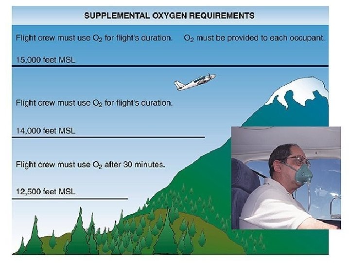
Altitude Selection • Based on: – MEA – ATC assigned lowest available IFR altitude – Highest altitude without oxygen – Winds, turbulence, and ice
• § 91. 177 Minimum altitudes for IFR operations – (a) Operation of aircraft at minimum altitudes. Except when necessary for takeoff or landing, no person may operate an aircraft under IFR below – • (1) The applicable minimum altitudes prescribed in parts 95 and 97 of this chapter; or • (2) If no applicable minimum altitude is prescribed in those parts – – (i) In the case of operations over an area designated as a mountainous area in part 95, an altitude of 2, 000 feet above the highest obstacle within a horizontal distance of 4 nautical miles from the course to be flown; or – (ii) In any other case, an altitude of 1, 000 feet above the highest obstacle within a horizontal distance of 4 nautical miles from the course to be flown. .
14 CFR 91. 177 • Minimum Altitudes for IFR Operations • Applicable minimums – Mountainous (2000’AGL / 4 nm) – Other (1000’AGL / 4 nm) – MEA / MOCA / 22 nm • Climb to higher minimum immediately, or MCA designated – (we’ll cover this in more detail in Enroute operations)
• § 91. 179 IFR cruising altitude or flight level – (a) In controlled airspace. Each person operating an aircraft under IFR in level cruising flight in controlled airspace shall maintain the altitude or flight level assigned that aircraft by ATC. However, if the ATC clearance assigns “VFR conditions on top” that person shall maintain an altitude or flight level as prescribed by § 91. 159. – (b) In uncontrolled airspace. Except while in a holding pattern of 2 minutes or less or while turning, each person operating an aircraft under IFR in level cruising flight in uncontrolled airspace shall maintain an appropriate altitude as follows: . • (1) When operating below 18, 000 feet MSL – – (i) on a magnetic course of zero degrees through 179 degrees, any odd thousand foot MSL altitude – (ii) on a magnetic course of 180 degrees through 359 degrees, any even thousand foot MSL altitude.
Completing the Nav Log • Helps to organize your flight • Concise textual description • Monitor your progress for subsequent change – ETE / ATE : ETA / ATA • See examples in chapter 10 C of your Jeppesen Test Guide – Compare what is on the FAA flight plan form to the Flight Log examples given. • Get some one-on-one instruction from your flight instructor when you start your IFR cross-country flying.
Flight Plan Example (Note: there should not be “K” in front of VOR identifiers in route section. That’s a misprint!)
Flight Planning
Filing the Flight Plan • Pilots should file flight plan at least 30 minutes prior to estimated time of departure to preclude possible delay in receiving ATC clearance.
Block 3: • Aircraft equipment suffix code: –Check AIM paragraph 5 -1 -7, Table 5 -1 -2 for appropriate code. • Note Equipment Headings on legend.
Filing Altitude: • File your initial cruising altitude. • With multiple cruising altitudes, list Altitude for first leg only.
Filing your route: • It is important that the route of flight be accurately and completely described in the flight plan. • If flight is to be conducted via designated airways, describe the route by indicating the type and number designators of the airway requested. If more than one airway is to be used, clearly indicate points of transition. If the transition is to be made at an unnamed intersection, show the next succeeding NAVAID or named intersection on the intended route and the complete route from that point. • Transfer from flight log to flight plan
Filing the Flight Plan • Route of Flight – Use Airways or Jet routes – using type and number designators • “V 433” for Victor Airway 433 • “J 14” for Jet Route 14 – Clearly indicate route requested with: • • Airways/ Route designators and Navigational Aids (VOR, VORTAC, NDB, etc. ) List Nav Aids only at route change points. FAA Data Base Waypoints (GPS, etc. )
Flight Planning • Filing your route – Example: Drake to Winslow via FERER would be filed: DRK V 562 FERER V 567 INW • Estimated time en route – The estimated flying time from departure point to destination (lift-off to touchdown) • Fuel On Board – Total fuel on board in hours & minutes
Flight Plan – IFR Flights Route of Flight (continued) – File a “Preferred Route” whenever appropriate. (See A/FD) – DPs, SIDs and STARs • May be issued by ATC as part of your clearance unless: • You write “NO DP”, “NO SID” or “NO STAR” in Remarks section, as appropriate.
Filing DP’s and STAR’s • How to file a DP or STAR – Departure name: ROCKI ONE DEPARTURE – Departure code: (ROCKI 1. ROCKI) • For filing a transition: – Transition name: MILIS – Transition code: (ROCKI 1. MILIS) – Arrival name: MOORPARK FOUR ARRIVAL – Arrival code: (FIM. MOOR 4) • For filing a transition: – Transition name: FRESNO – Transition code: (FAT. MOOR 4)
Flight Plan – IFR Flights • Direct Flights – Must be in radar environment. – The pilot is responsible for obstruction clearance requirements. Check OROCAs. – Defined by radio fixes: • All fixes/waypoints become “compulsory reporting points” • Must have minimum of one waypoint in each ARTCC. – Should be guided by… • • Standard Service Volume: AIM, par. 1 -1 -8 Below FL 180: Navaids should not be over 80 NM apart (L). 14, 500’ MSL to FL 180: Navaids not over 200 NM apart (H). FL 180 to 450: Navaids not over 260 NM apart (H).
Standard Service Volumes
Aircraft performance • Climb performance – Use the maximum rate-of-climb chart in POH to determine if the C 172 performance will be adequate for any given DP.
Flight Plan – Changes • Change in Flight Plan – – Change of altitude or flight level Change of destination Change of route AVERAGE TAS AT CRUISE… • Advise ATC if changes 5% OR 10 kts, whichever is greater. • Change In ETD (“proposed departure time”) – 1 hour after ETD – your FP may drop out of system. – Thus, if delayed over 1 hour: • Advise FSS/ ARTCC
Airborne Filing • Prior to entering controlled airspace when weather is below VFR… – Submit (file) a complete IFR flight plan • usually to FSS – Receive an ATC clearance from ARTCC • Air Filing to enter B, C, D, and E airspace • “Pop-up” IFR • Traffic permitting, otherwise: • May require a 30 min delay
Composite Flight Plans – VFR for one portion / IFR for another portion of flight – If VFR is first: • Report departure time to FSS • Request ATC clearance at appropriate point • Request closure of VFR flight plan (to FSS, center, or tower)
Composite Flight Plans • If IFR is first: – ATC will note actual departure time • and so should the pilot! – Note clearance limit ! – Clearance limit – reached without ATC clearance! (Now what? ) • MUST remain in VFR condition “until operating in accordance with the IFR clearance”
Closing the IFR Flight Plan • Required by 14 CFR Part 91. 169 • If landing on control tower airfield, cancelled automatically… however! • Other methods: – FSS on ground – ATC while airborne in VMC below 18, 000’ MSL. – State: “Cancel my IFR Flight Plan”
Simulated Instrument Flight – Cautions – Consult 91. 109 before “under the hood” flight is attempted – fly at or above published MEAs at night • Safety Pilot – possesses at least a Private Pilot Certificate with category and class ratings appropriate to the A/C, and a current medical. • Safety Pilot – adequate vision forward and side of A/C • Aircraft – has fully functioning dual controls (exception for “throw over control wheel)
14 CFR 91. 109 • Flight Instruction; Simulated Instrument Flight and Certain Flight Tests • Section (b) No person may operate an aircraft in simulated instrument flight unless – Safety pilot = private pilot rated in aircraft (Category/Class) – Safety pilot has adequate vision forward and side – Fully functioning dual controls
. • Use IFR Procedures in VFR Conditions – – Obtain complete briefing File flight plan Use current charts Use navigation aids – practice keeping needle centered – Maintain a constant altitude (appropriate for direction of flight) – Estimate enroute position times – Make accurate position reports to FSS • It is a great habit to get into…