Pilotage and Dead Reckoning Latitude and Longitude Latitude

")


 clock • E.")


 • Consider an Aircraft moving at 120 knots •")
 • Same Aircraft moving at 120 knots • Tailwind")
 • Same Aircraft moving at 120 knots • Headwind")


 • TC +/- VAR =")


 • Types of NOTAMS • (D) – Information that")


- Slides: 64
Pilotage and Dead Reckoning
Latitude and Longitude • Latitude • Line that parallels the equator (East to West) • Lies flat (f. Latitude) • North designation for us (we are north of Equator) 43°N • Longitude • Lines that Parallel the Prime Meridian (North to South) • Longer because earth is not a ball • West designation for us (we are west of the Prime Meridian) 119°W © 2015 Coast Flight Training. All Rights Reserved.
Latitude and Longitude • Degrees • Minutes • Seconds don’t really apply to us © 2015 Coast Flight Training. All Rights Reserved.
© 2015 Coast Flight Training. All Rights Reserved.
Latitude and Longitude Find on your own: What is the longitude and Latitude of Catalina Island? © 2015 Coast Flight Training. All Rights Reserved.
© 2015 Coast Flight Training. All Rights Reserved.
Time • Earth takes 24 hours to make complete revolution • 360 degrees (circumference of earth) / 24 hours = 15 degrees/hour • Noon: Sun is Directly overhead a meridian • To the West of that meridian = morning • To the East of that meridian = afternoon © 2015 Coast Flight Training. All Rights Reserved.
Time Zones • Each 15 degrees of longitude: new time zone • United States time zones: • • 75 Eastern 90 Central 105 Mountain 120 Pacific • Dividing lines are irregular due to communities at the borders © 2015 Coast Flight Training. All Rights Reserved.
Time Zones • Time differences to be taken into account during long flights east or westward • Remember: hour is lost when flying eastward from one time zone to another • Night time requirements – carriage of passengers • Determine the time of Sunset at the destination by consulting FSS © 2015 Coast Flight Training. All Rights Reserved.
Time Zones • In aviation, time uses a 24 hour (military) clock • E. g. 9 am = 0900, 10 pm = 2200 • Several time zones to cross – standard time selected • • Universal Time Coordinated (UTC) Referred to as Zulu time Time at the 0 degree of longitude – Greenwich, England All time zones around the world are in reference to UTC © 2015 Coast Flight Training. All Rights Reserved.
Time Zones in the US • Eastern Standard Time – Add 5 hours • Central Standard Time – Add 6 hours • Mountain Standard Time – Add 7 hours • Pacific Standard Time – Add 8 hours • For DST, subtract one hour from the above © 2015 Coast Flight Training. All Rights Reserved. If UTC is 5 pm (1700) Time Zone Known Time EST 1200 CST 1100 MST 1000 PST 0900
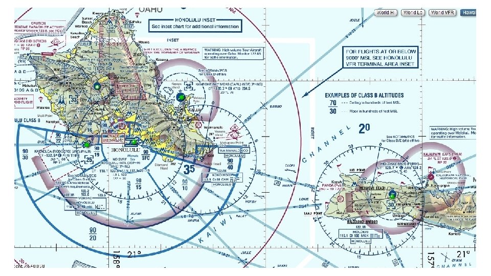
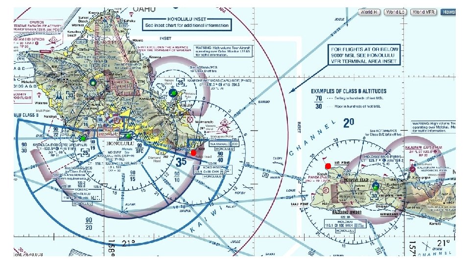
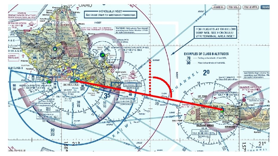
Planning a Flight From PHNL to PHMK
The Three Types of Navigation • Pilotage • Dead-Reckoning • Radio Navigation © 2015 Coast Flight Training. All Rights Reserved.
Pilotage • Fancy word for looking out the window • Navigating by Visual Landmarks • Most enjoyable way to navigate © 2015 Coast Flight Training. All Rights Reserved.
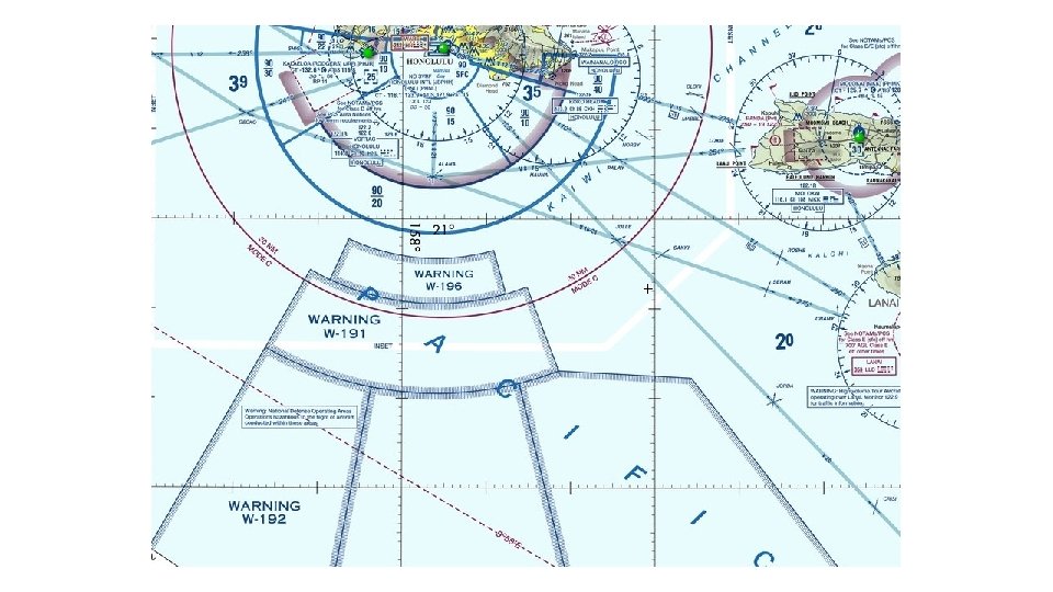
Course Considerations • What areas do you want to avoid? • Special Use Airspace • High Terrain • Sparse Landmarks • Measure the length of the course • Fuel Considerations • Too far? Find an FBO (Fixed-Base Operator) • Understand charges ahead of time • Nothing worse than getting hit with a $100 “unwaiverable” landing fee © 2015 Coast Flight Training. All Rights Reserved.
Checkpoints • When you have finalized your course, you can choose checkpoints • Best checkpoint is one that can’t be confused with anything else • Lake with distinctive shape • Major highway crossing river • Remember, must have a Checkpoint for TOC and TOD • Performance Charts! © 2015 Coast Flight Training. All Rights Reserved.
Measuring Direction • Draw a line from Point A to Point B • Measuring the angle between this line and the meridian would give you a True Course • This is now the direction in reference to True North • Cautions: • Always measure TC from the midpoint (meridians converge towards poles) © 2015 Coast Flight Training. All Rights Reserved.
Effects of Wind • Wind blowing from North at 25 knots – wind is moving southward at 25 nautical miles in 1 hour • Aircraft moving through air is affected by wind • Wind changes the ground speed © 2015 Coast Flight Training. All Rights Reserved.
Effects of Wind (Vector Addition) • Consider an Aircraft moving at 120 knots • Absent any wind, it’s groundspeed is 120 knots as well 120 NM Aircraft Speed Resultant = 120 NM / hr © 2015 Coast Flight Training. All Rights Reserved.
Effects of Wind (Vector Addition) • Same Aircraft moving at 120 knots • Tailwind (wind from behind) at 20 knots • Aircrafts groundspeed is 140 knots 120 NM Aircraft Speed Wind Resultant = 140 NM / hr © 2015 Coast Flight Training. All Rights Reserved.
Effects of Wind (Vector Addition) • Same Aircraft moving at 120 knots • Headwind (wind from front) at 20 knots • Aircrafts groundspeed is 140 knots 120 NM Aircraft Speed 20 NM Wind Resultant = 100 NM / hr © 2015 Coast Flight Training. All Rights Reserved.
Effects of Wind • Wind is not always from head on – but from a side • Must establish a wind correction angle that will counteract any effect of wind drift © 2015 Coast Flight Training. All Rights Reserved.
Wind Correction • Necessary to head aircraft in a slightly different direction • Think ground reference maneuvers – crab angle • The direction the nose is pointing in reference to True North is True Heading © 2015 Coast Flight Training. All Rights Reserved.
Wind Correction • Find Wind Direction and Heading • Use E 6 B to find Wind Correction Angle © 2015 Coast Flight Training. All Rights Reserved.
Wind Correction • True Course +/- Wind Correction Angle = True Heading • TC +/- WCA = TH © 2015 Coast Flight Training. All Rights Reserved.
Variation • Difference between True North and Magnetic North • North pole is 1300 miles away from Magnetic North Pole • Isogonic Lines listed on charts to help us find difference in relation to Magnetic North © 2015 Coast Flight Training. All Rights Reserved.
Variation © 2015 Coast Flight Training. All Rights Reserved.
Variation • Adjust that True Heading for Variation and you get a Magnetic Heading • TH +/- VAR = MH • Remember “East is Least, West is Best” • Also, see formula on E 6 B © 2015 Coast Flight Training. All Rights Reserved.
Deviation • Each aircraft has its own localized magnetic influences on compass • Pilot must add or subtract these influences • Technician will “swing” the compass and write the difference the compass shows between known headings • The compass deviation card is required for all aircraft • Mounted near the compass © 2015 Coast Flight Training. All Rights Reserved.
Deviation • Magnetic Heading adjusted for Deviation is the Compass Heading • MH +/- DEV = CH • Compass Heading is what the plane actually flies © 2015 Coast Flight Training. All Rights Reserved.
To Summarize • Course • Heading • Track • Drift Angle • WCA • Airspeed • Groundspeed – Intended path of the Aircraft over the ground – Direction in which the nose is pointed – Actual Path the plane makes over the ground – Angle between heading and track – Correction applied to counteract drift – Rate of aircraft’s progress through the air – Rate of aircraft’s progress over the ground © 2015 Coast Flight Training. All Rights Reserved.
Calculations • Converting Minutes to Hours: • Divide minutes by 60 30 minutes 60 minutes per hour = . 5 hours © 2015 Coast Flight Training. All Rights Reserved.
Calculations • Time from Distance and Groundspeed: • Distance divided by groundspeed = Time 100 NM/hour = 1 Hour © 2015 Coast Flight Training. All Rights Reserved.
Calculations • Distance from Time and Groundspeed: • Groundspeed multiplied by Time = Distance 100 NM / hour X 1 hour = 100 NM © 2015 Coast Flight Training. All Rights Reserved.
Calculations • Groundspeed from Distance and Time: • Distance divided by time = groundspeed 100 NM 1 hour = 100 NM/hr © 2015 Coast Flight Training. All Rights Reserved.
Calculations • Knots to MPH • Multiply Knots by 1. 15 to get MPH 100 Kts X 1. 15 = 115 MPH © 2015 Coast Flight Training. All Rights Reserved.
Calculations • Fuel Consumption • Gallons per hour divided by hours 10 gph. 5 hour = 5 gallons © 2015 Coast Flight Training. All Rights Reserved.
Flight Computer Questions • How far did I travel if my groundspeed was 123 knots and I traveled for 8 minutes? • How long does it take to travel 6 miles at 87 knots? • It took me 7 minutes to go 16 miles. How fast was I going? • How much fuel do I burn in that 7 minutes if I burn 13 gph? • What if I flew a twin-engine airplane for that 7 minutes and each engine burns 15 gallons per hour? © 2015 Coast Flight Training. All Rights Reserved.
Wind Computer / Triangle Questions • Based on the following chart, if flown at 120 KIAS, what is the WCA and Groundspeed at 9000 feet over LIH on a True Course of 310 degrees? © 2015 Coast Flight Training. All Rights Reserved.
Wind Computer / Triangle Questions • Based on the following chart, if flown at 125 KIAS, what is the WCA and Groundspeed at 12, 000 feet over OGG on a True Course of 125 degrees? © 2015 Coast Flight Training. All Rights Reserved.
Vocabulary • True Course – Direction of line between two desired points on chart • WCA – Difference between True Course and nose of aircraft • True Heading – Where the nose of the aircraft is pointed towards • Variation – Difference between True and Magnetic North • Mag. Heading – True Heading corrected for Variation • Deviation – The affects of the local electromagnetism • Compass Hdg. – Flown to get from point A to point B © 2015 Coast Flight Training. All Rights Reserved.
Vocabulary © 2015 Coast Flight Training. All Rights Reserved.
Cruising Altitudes • Determined by Magnetic Course (91. 159) • TC +/- VAR = Magnetic Course • 360 -179 = Odd Thousands + 500 Feet • 180 -359 = Even Thousands + 500 Feet © 2015 Coast Flight Training. All Rights Reserved.
Flight Planning Considerations • What are the Necessary Materials? • 91. 103: Pre-Flight Action: • • Notams Weather Known ATC Delays Runway Lengths Alternates Fuel Requirements Takeoff and Landing Distances © 2015 Coast Flight Training. All Rights Reserved.
91. 103 Caution “Each pilot in command shall, before beginning a flight, become familiar with all available information concerning that flight. This information must include…” © 2015 Coast Flight Training. All Rights Reserved.
NOTAMS (AIM 5 -1 -3) • Types of NOTAMS • (D) – Information that requires wide dissemination and pertains to enroute and landing areas listed in A/FD • FDC – Regulatory in nature: changes in charts, procedures, TFRs • (L) is discontinued • Where to get NOTAMS • Flight Service Station (Always ask) • Notams. aim. faa. gov • DUATS © 2015 Coast Flight Training. All Rights Reserved.
Weather • Types of Briefings • Standard • Abbreviated • Outlook • Official vs. Unofficial Sources • Where to get it? • DUATS (duats. com) Only works on Internet Explorer • FSS (Lockheed Martin) © 2015 Coast Flight Training. All Rights Reserved.
Known ATC Delays • Where to get them: • FSS • Fly. faa. gov © 2015 Coast Flight Training. All Rights Reserved.
Runway Lengths • Where to get them: • A/FD – Purchase one • Air. Nav • Sky. Vector © 2015 Coast Flight Training. All Rights Reserved.
Alternates • Choosing an Alternate • Considerations for • • Fuel Runway Lengths Weather ATC Delays © 2015 Coast Flight Training. All Rights Reserved.
Fuel Requirements • Fuel Required for VFR Flight • Use the Performance Charts for Climb and Descent fuel • Decide on Fuel Requirements before departure • Air. Nav has FBO Fuel Pricing © 2015 Coast Flight Training. All Rights Reserved.
© 2015 Coast Flight Training. All Rights Reserved.
Takeoff & Landing Distances • Performance Charts • Remember that Density Altitude may change during the time you departed and the time you arrive at your destination • E. g. Big Bear © 2015 Coast Flight Training. All Rights Reserved.
Types of Flight Plans • VFR • Visual Flight Rules – mainly for S&R Purposes • IFR • Must be filed prior to any flight under IFR • DVFR • Must be filed and clearance received prior to crossing an ADIZ © 2015 Coast Flight Training. All Rights Reserved.
Filing the Flight Plan • Is it required? • Why do we file? • How to open VFR Flight Plan • While in air • How to close VFR Flight Plan • Lockheed Martin FSS • ATC DOES NOT CLOSE FOR YOU! © 2015 Coast Flight Training. All Rights Reserved.
Lost Procedures • Dangerous due to Fuel • Common sense procedures • Climb • Circle • Confess • Communicate • Comply © 2015 Coast Flight Training. All Rights Reserved.
Diversions • May not be able to make it to planned destination • Hard because of limited flight deck space • Compute: • • • Course Time Speed Distance Fuel © 2015 Coast Flight Training. All Rights Reserved.
Diversions • Measure course with protractor or plotter • Consider straightedge with compass rose on VOR • Consider navigating to an airport with a VOR or NDB • Start diversion over ground feature • Unless emergency – divert promptly © 2015 Coast Flight Training. All Rights Reserved.
Diversions • Calculate point to point ground speed • Priority must be placed on flying the aircraft • Allowed to use Autopilot, but don’t use it as a crutch • Remember: • Course – DTF (Distance, Time, and Fuel) © 2015 Coast Flight Training. All Rights Reserved.
References • Pilot’s Handbook of Aeronautical Knowledge Chapter 15 • Jeppesen Private Pilot Guided Flight Discovery © 2015 Coast Flight Training. All Rights Reserved.