Unit 3 Understanding Coordinate Systems Student Learning Outcomes


 • Used Clarke 1866")
 • Based on Doppler")


 3 D")


 • Global coordinate system • Divides Earth into zones that")


 Ellipsoid")


- Slides: 83
Unit 3: Understanding Coordinate Systems Student Learning Outcomes: Students will be able to select the appropriate coordinate system for a given task and project or re-project data acquired as needed after consulting the metadata to determine its spatial reference.
Understanding Coordinate Systems and Map Projections
Why do I need to know this? • GIS works with spatial data • Data needs to be placed at a location • Globes are great for visualization, but not practical for many uses • A round Earth does not fit without distortion on a flat piece of paper
Datum
Datum • A datum is a reference surface for measuring locations on the earth • A datum has two major components • Specification of an ellipsoid • Set of points and lines that have been surveyed and defines the origin and orientation of latitude and longitude lines
Common Datums • North American Datum of 1927 (NAD 27) • Used Clarke 1866 Ellipsoid • Held fixed latitude and longitude in Kansas • Adjusted lat/lon for ~26, 000 points • North American Datum of 1983 (NAD 83) • Successor of NAD 27 • Used Earth-centered reference ellipsoid (GRS 80) rather than fixed station in Kansas • Adjusted lat/lon for ~250, 000 points
Common Datums • World Geodetic System of 1984 (WGS 84) • Based on Doppler satellite measurements • Based on WGS 84 ellipsoid, which is similar to the GRS 80 ellipsoid • Datums do see updates and adjustments • Both NAD 83 and WGS 84 have been updated multiple times
Vertical Datums • Vertical Datum – a reference for specifying heights • Established through a set of surveyed control points
Vertical Datums • Two most common vertical datums for North America • National Geodeteic Vertical Datum of 1929 (NGVD 29) • North American Vertical Datum of 1988 (NAVD 88)
Coordinates
Coordinates • Space is important • How can we represent this space numerically? • 2 D and 3 D
3 D Coordinate System
Spherical Coordinates • 3 D only • Does not ignore curvature of Earth • Uses two angles of rotation (Lat/Lon) and radius to specify locations
Longitude aka Meridian East • Measures East-West • Vary from +180° E to -180° W 20° -150° 10° -140° 0° -130° t -120° W -110° -100° es -10° -20° -30° -40° -90° -50° -60° -80° -70° Meridians
Latitude aka Parallels • Measures North-South • Vary from +90° N to -90° S North Pole 90° 80° N 70° 60° 50° 40° 30° Equator 20° 10° 20° 30° S Parallels
Spherical Coordinate Representation • Both latitude and longitude are typically represented in two ways • Degrees, Minutes, Seconds (DMS) • -34° 23’ 45. 23” , +124° 12’ 45. 32” • Decimal Degrees (DD) used by computers • -34. 395897 , 124. 212589
2 D Coordinate Systems
Cartesian Coordinates • Define spatial location and extent 2 D (x, y) 3 D (x, y, z)
Cartesian Coordinates • GIS data typically uses Cartesian system • Ignores curvature of Earth • For small areas, usually acceptable
Cartesian Coordinate Representation • Many possible representations • Could even make your own • Common Representations • State Plane Coordinate System (SPCS) • Universal Transverse Mercator Coordinate System (UTM)
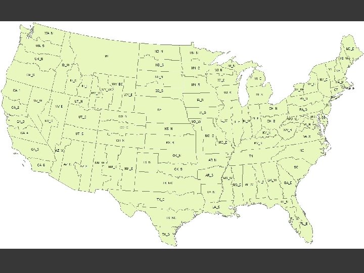
State Plane Coordinate System • Set of 126 geographic zones • Designed for specific regions of USA • Useful because… • Simple calculations • Accurate within zones • Comes in NAD 27 and NAD 83 flavors • Coordinates represented in Feet
State Plane Coordinate System • Each state may have multiple State Plane zones • Provides a common coordinate reference for horizontal coordinates over county areas while limiting error to specified maximums • Based on two types of map projections • Lambert conformal conic • Transverse Mercator
Universal Transverse Mercator Coordinate System • A set of 60 zones across the World • Useful because… • Simple calculations • Accurate within zones • Coordinates represented in Meters
Universal Transverse Mercator (UTM) • Global coordinate system • Divides Earth into zones that are 6° wide and extend from 80°S to 84°N • Numbered from 1 to 60 heading East from 180°W • Zones also split into North and South at Equator • UTM is common for data and study areas that cover large regions • Coordinates always positive and specified in Eastings (Y), and Northings (X)
Map Projections
Map Projections • Short introductory video: • http: //www. youtube. com/watch? v=2 Lcy. Mem. J 3 d. E
Map Projections • Map Projection – systematic rendering of locations from the curved Earth surface onto a flat map surface • Purpose: • Practical way to portray the Earth’s curvature on a flat surface. • Hard to carry a globe in a pocket!
Map Projections • Basic illustrative idea of a map project Map (flat surface) Ellipsoid Light
Developable Surfaces
Developable Surfaces • Developable Surface- Geometric surface onto which the curved surface of the Earth is projected. • Four geometric forms Plane Cylinder Cone Mathematical
Developable Surfaces • Developable surfaces are placed relative to the spheroid/ellipsoid in different locations and at different rotations to gain the desired view and map properties.
Interaction between Developable Surfaces and the Spheroid/Ellipsoid • Developable surface touches spheroid/ellipsoid in either: • Two secant lines • One point or tangent line Sec ant Tangent
Interaction between Developable Surfaces and the Spheroid/Ellipsoid Tangent interaction Ta Secant interaction ng en t lin e Secant line
Map Projection Parameters
Map Projection Parameters • • • Standard Points and Lines Projection Aspect Central Meridian Latitude of Origin Light Source Location
Standard Points and Lines Definition: Points or lines of intersection between the developable surface and spheroid. Named Standard Lines: If standard line falls a line of latitude, it is known as a standard parallel. If standard line falls on a line of longitude, it is known as a standard meridian.
Standard Parallels
Why are Standard Points and Lines Important? Those corresponding places on the map will have no scale distortion. The father away from the standard point or line(s), the greater the distortion or deformation occurs. Secants can help minimize distortion over a large area by providing addition control.
Projection Aspect Definition: Position of the projected graticule relative to ordinary position of the geographic grid on Earth A developable surface with the axis running from north to south pole creates a normal aspect
Globe Normal Axis
Normal Aspect
Non-Normal Aspect
Central Meridian Definition: The meridian that defines the center of the projection. i. e. the meridian in the center of the map
Latitude of Origin Definition: The Latitude that defines the center of the projection. i. e. the latitude in the center of the map
Light Source Location Definition: The location of the hypothetical light source in reference to the globe being projected. Three Primary Positions…
Three Primary Positions of Light Sources Gnomonic Stereographic Orthographic
Map Projection Properties
Map Projection Properties Definition: Alterations of area, shape, distance, and direction on map projections. Why? All maps contain error because of the 3 D -> 2 D transformation process. How? Rendering a spherical surface on a plane causes tearing, shearing, or compression of the surface.
Four Map Projection Properties Area Shape Distance Direction
Four Projection Properties Major Properties Area Shape Mutually Exclusive Minor Properties Distance Direction Cannot exist everywhere on map
Map Distortion • Distortions are unavoidable when making flat maps of a globe • Distortion may take different forms in different parts of the map • Few points where distortions are zero • Distortion is usually less near the points or lines of intersection where the map surface intersects the globe
Map Distortion • A map can show one or more – but never all – of the following at the same time: • True directions • True distances • True areas • True shapes
Area Equal Area Map Projection A. K. A. Equivalent Map Projection Goal: Preserve area relationships of all parts of globe Identifying Marks: Meridians and parallels are not at right angles. Distance distortion is often present. Shape is often skewed.
Area Equal Area Map Projection Useful for… General quantitative thematic maps. When it is desirable to retain area properties.
Area Cylindrical Equal-Area
Area Hammer-Aitoff
Shape Conformal Map Projection A. K. A. Orthomorphic Map Projection Goal: Preserve angles around points and shape of small areas Same scale in all directions from/to a point. Identifying Marks: Meridians intersect parallels at right angles. Areas distorted significantly at small scales. Shapes of large regions may be severely distorted.
Shape Conformal Map Projection Useful for… Large-scale mapping. Phenomena with circular radial patterns (e. x. radio broadcasts, average wind directions)
Shape Mercator Projection
Distance Equidistant Map Projection Goal: Preserve great circle distances. Distance can be held true from one to all other points, or from a few points to others, but not from all points to all other points. Scale is uniform along lines of true distance. Identifying Marks: Neither conformal or equal area, and look less distorted.
Distance Equidistant Map Projection Useful For… General Purpose Maps Atlas Maps
Distance Equidistant Cylindrical
Direction Azimuthal Map Projection A. K. A. True Direction Goal: Preserve true direction from one point to all other points. Direction not true between non-central points. Useful for… Preserving direction from one point.
Direction Azimuthal Equidistant Map Projection
Combination of Projections on a Single Projection Equal Area Conformal Equidistant Azimuthal Equal Area -- No No Yes Conformal No -- No Yes Equidistant No No -- Yes Azimuthal Yes Yes -- Yes denotes they can be combined No denotes they cannot be combined
Minimum Error Map Projection A. K. A. Compromise Map Projection Goal: Simultaneously minimize all four map projection properties Useful for… General geographic cartography
Minimum Error Robinson Map Projection
Organization of Cartographers for Social Equality – West Wing Clip http: //www. youtube. com/watch? v=n 8 z. BC 2 dv. ERM
Determining Deformation and its Distribution Over the Projection
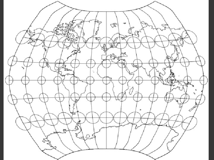
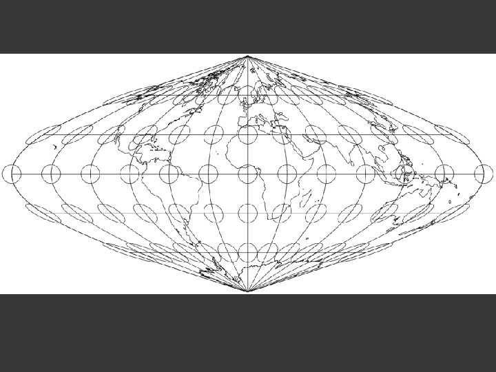
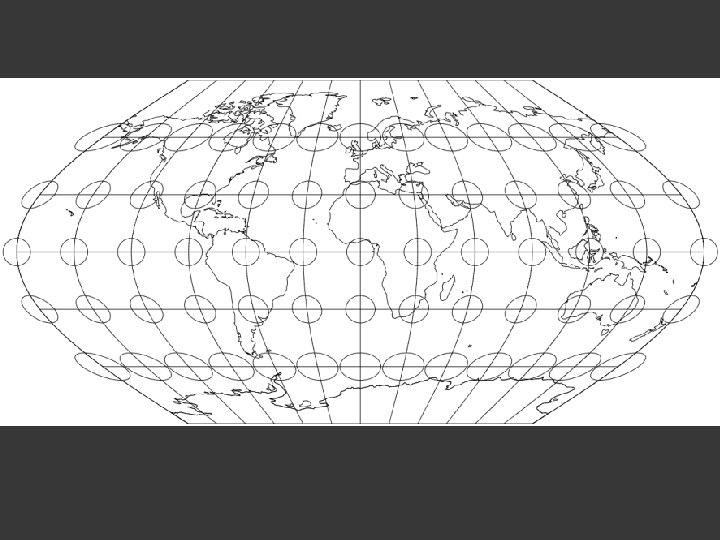
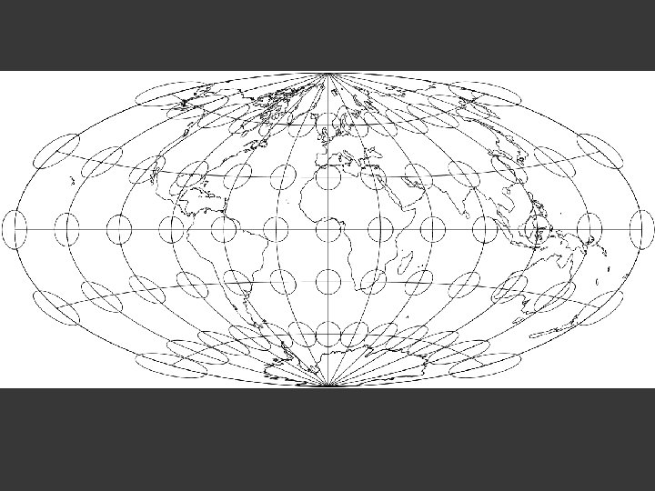
Tissot’s Indicatrix n n All flat maps distort shape, area, direction, or length Tissot’s Indicatrix helps to quantify distortion and projection properties • Composed of infinitesimally small circles centered at points on the Earth • Consider the shape of the circle after projecting the map
Tissot’s Indicatrix Interpretation: See what happens to the circles when you project
Interpreting Tissot’s Indicatrix Equal Area: Circle transformed into ellipse, but area remains the same. Conformal: Circle transformed as a circle, but size varies over the map.
Conformal Projection Property • Conformal – ellipse would remain circular, although most likely larger or smaller than original circle Mercator Projection
Equal Area Projection Property • Equal Area – Circle would not have same shape, but would have the same area as original Flat Polar Quartic Projection
Other Projection Properties • Equidistant – distances are true between two points Equidistant Cylindrical Projection
Other Projection Properties • Aphylactic – projections that distort everything Robinson Projection
Map Projection Reference Websites • USGS Map Projections Poster • http: //egsc. usgs. gov/isb/pubs/Map. Projections/projections. html • Radical Cartography Projection Reference • http: //www. radicalcartography. net/? projectionref • Flex Projector • http: //www. flexprojector. com/