UNIT V SATELLITE APPLICATIONS INTELSAT Series INTELSAT stands


 System Was Commissioned With The Launch")


. üChemist shops")


 • These digital telephones include")
 T v. The NSS provides the")


 The Global Positioning System (GPS) is a satellite based navigation")


 Earth Orbit satellites are positioned over the equator. v. The")


")
 üSatellites provide broadcast transmissions in the fullest sense of the")


 üDTH stands for Direct-To-Home television. DTH is defined as")


 üDAB Project is an industry-led consortium of over 300 companies")
 is the world's only global media and")

 - Adaptations for Education ü Business television (BTV) is the production")
")


 v. Video conferencing technology can be used to provide the")

- Slides: 76
UNIT V SATELLITE APPLICATIONS INTELSAT Series : üINTELSAT stands for International Telecommunications Satellite. üThe organization was created in 1964 and currently has over 140 member countries and more than 40 investing entities. üJuly 2001 INTELSAT became a private company and in May 2002 the company began providing end-to-end solutions through a network of teleports, leased fiber, and points of presence (Po. Ps) around the globe.
INSAT • INSAT or the Indian National Satellite System is a series of multipurpose geo-stationary satellites launched by ISRO to satisfy the telecommunications, broadcasting, meteorology, and search and rescue operations. • Commissioned in 1983, INSAT is the largest domestic communication system in the Asia Pacific Region. • It is a joint venture of the Department of Space, Department of Telecommunications, India Meteorological Department, All India Radio and Doordarshan. The overall coordination and management of INSAT system rests with the Secretary-level INSAT Coordination Committee. • INSAT satellites provide transponders in various bands (C, S, Extended C and Ku) to serve the television and communication needs of India. Some of the satellites also have the Very High Resolution Radiometer (VHRR), CCD cameras for metrological imaging. • The satellites also incorporate transponder(s) for receiving distress alert signals for search and rescue missions in the South Asian and Indian Ocean Region, as ISRO is a member of the Cospas-Sarsat programme.
INSAT System • The Indian National Satellite (INSAT) System Was Commissioned With The Launch Of INSAT-1 B In August 1983 • INSAT-1 A, The First Satellite Was Launched In April 1982 But Could Not Fulfil The Mission. • INSAT System Ushered In A Revolution In India’s Television And Radio Broadcasting, Telecommunications And Meteorological Sectors. • It Enabled The Rapid Expansion Of TV And Modern Telecommunication Facilities To Even The Remote Areas And Off-Shore Islands.
Satellites In Service • Of The 24 Satellites Launched In The Course Of The INSAT Program, 10 Are Still In Operation. • INSAT-2 E It Is The Last Of The Five Satellites In INSAT-2 Series{Prateek }. • It Carries Seventeen C-Band And Lower Extended C-Band Transponders Providing Zonal And Global Coverage With An Effective Isotropic Radiated Power (EIRP) Of 36 Dbw. • It Also Carries A Very High Resolution Radiometer ( VHRR) With Imaging Capacity • In The Visible (0. 55 -0. 75 µm), • Thermal Infrared (10. 5 -12. 5 µm) And Water Vapour (5. 7 -7. 1 µm) Channels • Provides 2 x 2 Km, 8 x 8 Km And 8 x 8 Km Ground Resolution Respectively.
INSAT-3 A • The Multipurpose Satellite, INSAT-3 A, Was Launched By Ariane In April 2003. • It Is Located At 93. 5 Degree East Longitude. • The Payloads On INSAT-3 A Are As Follows: • 12 Normal C-Band Transponders (9 Channels Provide Expanded Coverage From Middle East To South East Asia With An EIRP Of 38 Dbw, 3 Channels Provide India Coverage With An EIRP Of 36 Dbw And 6 Extended C-Band Transponders Provide India Coverage With An EIRP Of 36 Dbw). • A CCD Camera Provides 1 x 1 Km Ground Resolution, In The Visible (0. 630. 69 µm), Near Infrared (0. 77 -0. 86 µm) And Shortwave Infrared (1. 55 -1. 70 µm) Bands.
INSAT-3 D • Launched In July 2013 • INSAT-3 D Is Positioned At 82 Degree East Longitude. • INSAT-3 D Payloads Include Imager, Sounder, Data Relay Transponder And Search & Rescue Transponder. • All The Transponders Provide Coverage Over Large Part Of The Indian Ocean Region Covering India, Bangladesh, Bhutan, Maldives, Nepal, Seychelles, Sri Lanka And Tanzania For Rendering Distress Alert Services
• INSAT-3 E • Launched In September 2003 • INSAT-3 E Is Positioned At 55 Degree East Longitude And Carries 24 Normal C-Band Transponders Provide An Edge Of Coverage EIRP Of 37 Dbw Over India And 12 Extended C-Band Transponders Provide An Edge Of Coverage EIRP Of 38 Dbw Over India. • KALPANA-1 Is An Exclusive Meteorological Satellite Launched By PSLV In September 2002. • It Carries Very High Resolution Radiometer And DRT Payloads To Provide Meteorological Services. • It Is Located At 74 Degree East Longitude. Its First Name Was METSAT. • It Was Later Renamed As KALPANA 1 To Commemorate Kalpana Chawla.
Edusat
Edusat • Configured For Audio-Visual Medium Employing Digital Interactive Classroom Lessons And Multimedia Content, EDUSAT Was Launched By GSLV In September 2004. • Its Transponders And Their Ground Coverage Are Specially Configured To Cater To The Educational Requirements. • GSAT-2 Launched By The Second Flight Of GSLV In May 2003, GSAT-2 Is Located At 48 Degree East Longitude And Carries Four Normal C-Band Transponders To Provide 36 Dbw EIRP With India Coverage, Two Ku Band Transponders With 42 Dbw EIRP Over India And An MSS Payload Similar To Those On INSAT-3 B And INSAT-3 C.
INSAT-4 Series ü INSAT-4 A is positioned at 83 degree East longitude along with INSAT-2 E and INSAT-3 B. ü It carries 12 Ku band 36 MHz bandwidth transponders employing 140 W TWTAs to provide an EIRP of 52 d. BW at the edge of coverage polygon with footprint covering Indian main land 12 C-band 36 MHz bandwidth transponders provide an EIRP of 39 d. BW at the edge of coverage with expanded radiation patterns encompassing Indian geographical boundary, area beyond India in southeast and northwest regions. ü Tata Sky, a joint venture between the TATA Group and STAR uses INSAT-4 A for distributing their DTH service. INSAT-4 A INSAT-4 B Glitch In INSAT 4 B China-Stuxnet Connection INSAT-4 CR GSAT-8 / INSAT-4 G GSAT-12 /GSAT-10
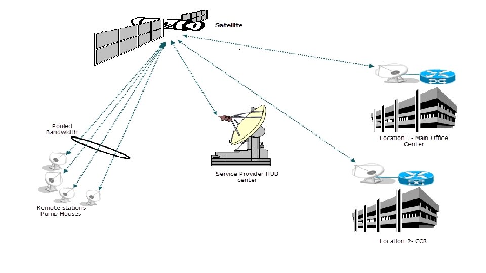
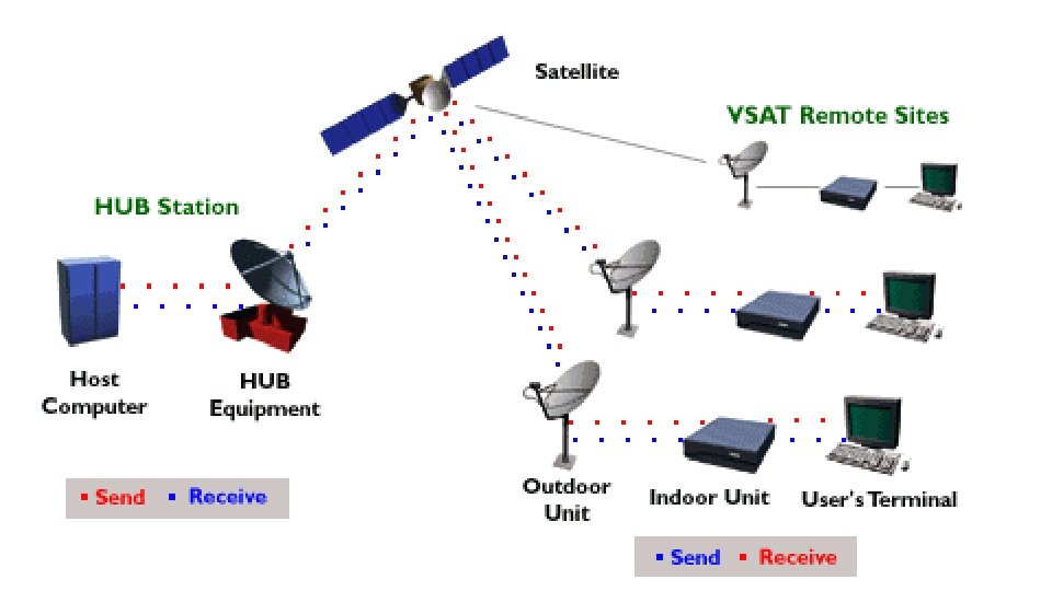
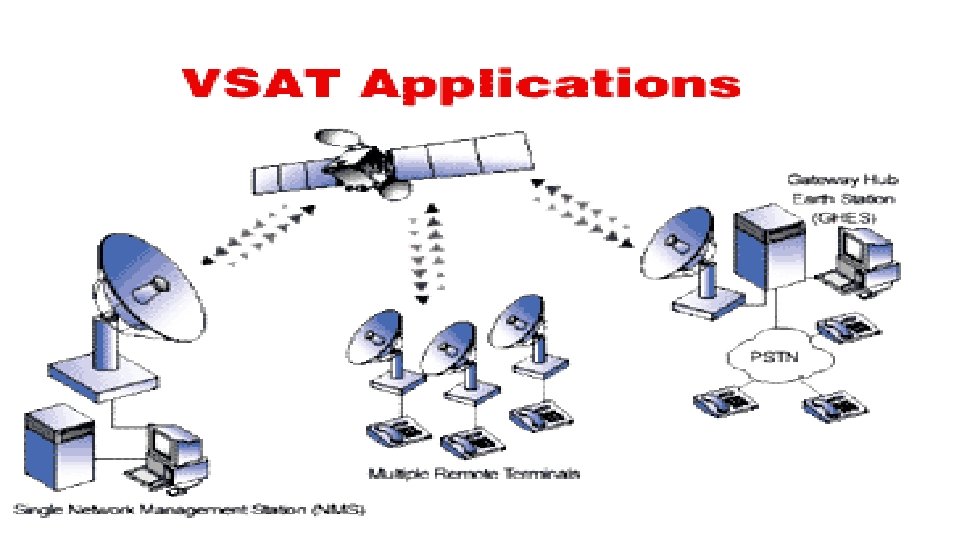
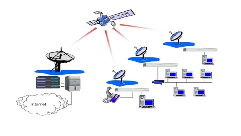
VSAT • VSAT stands for very small aperture terminal • • system. This is the distinguishing feature of a VSAT system, the earth-station antennas being typically less than 2. 4 m in diameter (Rana et al. , 1990). The trend is toward even smaller dishes, not more than 1. 5 m in diameter (Hughes et al. , 1993). In this sense, the small TVRO terminals for direct broadcast satellites could be labeled as VSATs, but the appellation is usually reserved for private networks, mostly providing two-way communications facilities. Typical user groups include banking and financial institutions, airline and hotel booking agencies, and large retail stores with geographically dispersed outlets.
VSAT network üThe basic structure of a VSAT network consists of a hub station which provides a broadcast facility to all the VSATs in the network and the VSATs themselves which access the satellite in some form of multiple- access mode. üThe hub station is operated by the service provider, and it may be shared among a number of users, but of course, each user organization has exclusive access to its own VSAT network. üTime division multiplex is the normal downlink mode of transmission from hub to the VSATs, and the transmission can be broadcast for reception by all the VSATs in a network, or address coding can be used to direct messages to selected VSATs. üA form of demand assigned multiple access (DAMA) is employed in some systems in which channel capacity is assigned in response to the fluctuating demands of the VSATs in the network. üMost VSAT systems operate in the Ku band, although there are some C band systems in existence (Rana et al. , 1990).
Applications üSupermarket shops (tills, ATM machines, stock sale updates and stock ordering). üChemist shops Shoppers Drug Mart Pharmaprix. üBroadband direct to the home. e. g. Downloading MP 3 audio to audio players. üBroadband direct small business, office etc, sharing local use with many PCs. üInternet access from on board ship Cruise ships with internet cafes, commercial shipping communications
Mobile satellite services: GSM Services and Architecture : üIf your work involves (or is likely to involve) some form of wireless public communications, you are likely to encounter the GSM standards. üInitially developed to support a standardized approach to digital cellular communications in Europe, the "Global System for Mobile Communications" (GSM) protocols are rapidly being adopted to the next generation of wireless telecommunications systems. üIn the US, its main competition appears to be the cellular TDMA systems based on the IS-54 standards. Since the GSM systems consist of a wide range of components, standards, and protocols.
üThe GSM and its companion standard DCS 1800 (for the UK, where the 900 MHz frequencies are not available for GSM) have been developed over the last decade to allow cellular communications systems to move beyond the limitations posed by the older analog systems. üAnalog system capacities are being stressed with more users that can be effectively supported by the available frequency allocations ü. Compatibility between types of systems had been limited, if non-existent. üBy using digital encoding techniques, more users can share the same frequencies than had been available in the analog systems. üAs compared to the digital cellular systems in the US (CDMA [IS-95] and TDMA [IS-54]) , the GSM market has had impressive success. üEstimates of the numbers of telephones run from 7. 5 million GSM phones to. 5 million IS 54 phones to. 3 million for IS 95.
üGSM has gained in acceptance from its initial beginnings in Europe to other parts of the world including Australia, New Zealand, countries in the Middle East and the far east. ü Beyond its use in cellular frequencies (900 MHz for GSM, 1800 MHz for DCS 1800), portions of the GSM signaling protocols are finding their way into the newly developing PCS and LEO Satellite communications systems. üWhile the frequencies and link characteristics of these systems differ from the standard GSM air interface. ü all of these systems must deal with users roaming from one cell (or satellite beam) to another, and bridge services to public communication networks including the Public Switched Telephone Network (PSTN), and public data networks (PDN).
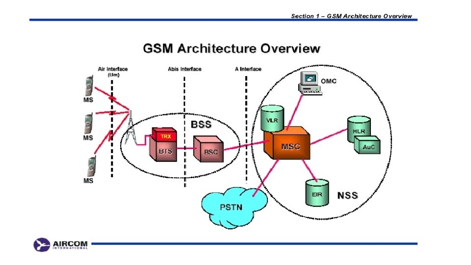
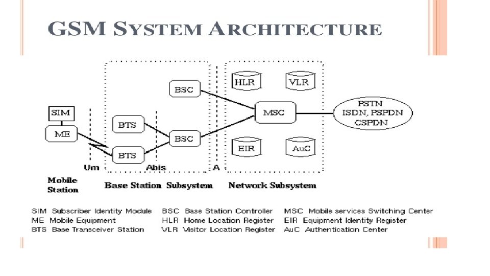
GSM architecture includes several subsystems üThe Mobile Station (MS) • These digital telephones include vehicle, portable and hand-held terminals. • A device called the Subscriber Identity Module (SIM) that is basically a smart-card provides custom information about users such as the services they've subscribed to and their identification in the network üThe Base Station Sub-System (BSS) • The BSS is the collection of devices that support the switching networks radio interface. • Major components of the BSS include the Base Transceiver Station (BTS) that consists of the radio modems and antenna equipment. • In OSI terms, the BTS provides the physical interface to the MS where the BSC is responsible for the link layer services to the MS. • Logically the transcoding equipment is in the BTS, however, an additional component
• The Network and Switching Sub-System (NSS) T v. The NSS provides the switching between the GSM subsystem and external networks along with the databases used for additional subscriber and mobility management. üMajor components in the NSS include Øthe Mobile Services Switching Center (MSC), ØHome and Visiting Location Registers (HLR, VLR). Ø The HLR and VLR databases are interconnected through the telecomm standard Signaling System 7 (SS 7) control network. üThe Operation Sub-System (OSS) üThe OSS provides the support functions responsible for the management of network maintenance and services. üComponents of the OSS are responsible for network operation and maintenance, mobile equipment management, and subscription management and charging.
Several channels are used in the air interface ü FCCH - the frequency correction channel - provides frequency synchronization information in a burst ü SCH - Synchronization Channel - shortly following the FCCH burst (8 bits later), provides a reference to all slots on a given frequency ü PAGCH - Paging and Access Grant Channel -used for the transmission of paging information requesting the setup of a call to a MS. ü RACH - Random Access Channel - an inbound channel used by the MS to request connections from the ground network. Since this is used for the first access attempt by users of the network, a random access scheme is used to aid in avoiding collisions. ü CBCH - Cell Broadcast Channel - used for infrequent transmission of broadcasts by the ground network. ü BCCH - Broadcast Control Channel - provides access status information to the MS. The information provided on this channel is used by the MS to determine whether or not to request a transition to a new cell ü FACCH - Fast Associated Control Channel for the control of handovers ü TCH/F - Traffic Channel, Full Rate for speech at 13 kbps or data at 12, 6, or 3. 6 kbps ü TCH/H - Traffic Channel, Half Rate for speech at 7 kbps, or data at 6 or 3. 6 kbps
GSM service security ØGSM was designed with a moderate level of service security. Ø GSM uses several cryptographic algorithms for security. ØThe A 5/1, A 5/2, and A 5/3 stream ciphers are used for ensuring overthe-air voice privacy. ØGSM uses General Packet Radio Service ( GPRS) for data transmissions like browsing the web. Ø The most commonly deployed GPRS ciphers were publicly broken in 2011 The researchers revealed flaws in the commonly used GEA/1.
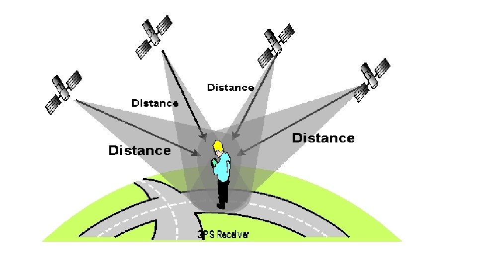
Global Positioning System (GPS) The Global Positioning System (GPS) is a satellite based navigation system that can be used to locate positions anywhere on earth. üOperated by the U. S. Department of Defense ü it consists of satellites, control and monitor stations, and receivers. ü GPS receivers take information transmitted from the satellites and uses triangulation to calculate a user’s exact location. üGPS is used on incidents in a variety of ways ü
ØTo determine position locations for example, you need to radio a helicopter pilot the coordinates of your position location so the pilot can pick you up. ØTo navigate from one location to another for example, you need to travel from a lookout to the fire perimeter. ØTo create digitized maps for example, you are assigned to plot the fire perimeter and hot spots. ØTo determine distance between two points or how far you are from another location.
F i g u r e 5.
Three Segments of GPS: Space Segment — Satellites orbiting the earth ü consists of 29 satellites circling the earth every 12 hours at 12, 000 miles in altitude. ü This high altitude allows the signals to cover a greater area. ü The satellites are arranged in their orbits so a GPS receiver on earth can receive a signal from at least four satellites at any given time. ü Each satellite contains several atomic clocks. Control Segment — The control and monitoring stations ü Tracks the satellites and then provides them with corrected orbital and time information. ü consists of five unmanned monitor stations and one Master Control Station. ü The five unmanned stations monitor GPS satellite signals and then send that information to the Master Control Station where anomalies are corrected and sent back to the GPS satellites through ground antennas. User Segment — The GPS receivers owned by civilians and military ü The user segment consists of the users and their GPS receivers. ü The number of simultaneous users is limitless.
How GPS Determines a Position ØThe GPS receiver uses the following information to determine a position. v. Precise location of satellites • When a GPS receiver is first turned on, it downloads orbit information from all the satellites called an almanac. • This process, the first time, can take as long as 12 minutes; but once this information is downloaded, it is stored in the receiver’s memory for future use. v. Distance from each satellite • The GPS receiver calculates the distance from each satellite to the receiver by using the distance formula: distance = velocity x time. • The receiver already knows the velocity, which is the speed of a radio wave or 186, 000 miles per second (the speed of light). v. Triangulation to determine position • The receiver determines position by using triangulation. • When it receives signals from at least three satellites the receiver should be able to calculate its approximate position (a 2 D position). • The receiver needs at least four or more satellites to calculate a more accurate 3 D position.
Using a GPS Receiver v. There are several different models and types of GPS receivers. • Refer to the owner’s manual for your GPS receiver and practice using it to become proficient. v. When working on an incident with a GPS receiver it is important to: üAlways have a compass and a map. üHave a GPS download cable. üHave extra batteries. üKnow memory capacity of the GPS receiver to prevent loss of data, decrease in accuracy of data, or other problems. üUse an external antennae whenever possible, especially under tree canopy, in canyons, or while flying or driving. üSet up GPS receiver according to incident or agency standard regulation; coordinate system. üTake notes that describe what you are saving in the receiver.
INMARSAT
INMARSAT Ø Inmarsat-Indian Maritime SATellite Ø sole IMO-mandated provider of satellite communications for the GMDSS Ø Global Maritime Distress and Safety System (GMDSS) Ø Availability for GMDSS is a minimum of 99. 9% Ø Inmarsat has constantly and consistently exceeded this figure & Independently audited by IMSO and reported on to IMO. Ø Now Inmarsat commercial services use the same satellites and network Ø Inmarsat A closes at midnight on 31 December 2007 Agreed by IMO – MSC/Circ. 1076. Ø Successful closure programme almost concluded Overseen throughout by IMSO.
GMDSS services continue to be provided by üInmarsat B, Inmarsat C/mini-C and Inmarsat Fleet F 77 ü Potential for GMDSS on Fleet Broadband being assessed ü The IMO Criteria for the Provision of Mobile Satellite Communications Systems in the Global Maritime Distress and Safety System (GMDSS) ü Amendments were proposed; potentially to make it simpler for other satellite systems to be approved ü The original requirements remain and were approved by MSC 83 ü No dilution of standards ü Minor amendments only; replacement Resolution expected to be approved by the IMO 25 th Assembly ü Inmarsat remains the sole, approved satcom provider for the GMDSS
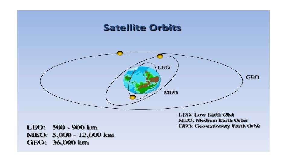
v. Low Earth Orbit satellites have a small area of coverage. v. They are positioned in an orbit approximately 3000 km from the surface of the earth ü They complete one orbit every 90 minutes ü The large majority of satellites are in low earth orbit ü The Iridium system utilizes LEO satellites (780 km high) ü The satellite in LEO orbit is visible to a point on the earth for a very short time LEO
MEO ü Medium Earth Orbit satellites have orbital altitudes between 3, 000 and 30 , 000 km. üThey are commonly used in navigation systems such as GPS
GEO v Geosynchronous (Geostationary) Earth Orbit satellites are positioned over the equator. v. The orbital altitude is around 30, 000 -40 , 000 km v. There is only one geostationary orbit possible around the earth � Lying on the earth’s equatorial plane. ü The satellite orbiting at the same speed as the rotational speed of the earth on its axis. ü They complete one orbit every 24 hours. This causes the satellite to appear stationary with respect to a point on the earth, allowing one satellite to provide continual coverage to a given area on the earth's surface ü One GEO satellite can cover approximately 1/3 of the world’s surface v. They are commonly used in communication systems v. Advantages: ü Simple ground station tracking. ü Nearly constant range � Very small frequency shift � Disadvantages: ü Transmission delay of the order of 250 msec. � Large free space loss. ü No polar coverage
Satellite orbits in terms of the orbital height v. According to distance from earth: ü Geosynchronous Earth Orbit (GEO) , ü Medium Earth Orbit (MEO), ü Low Earth Orbit (LEO)
Satellite Navigational System Benefits: • Enhanced Safety • Increased Capacity • Reduced Delays Advantage: • Increased Flight Efficiencies • Increased Schedule Predictability • Environmentally Beneficial Procedures
Direct Broadcast satellites (DBS)
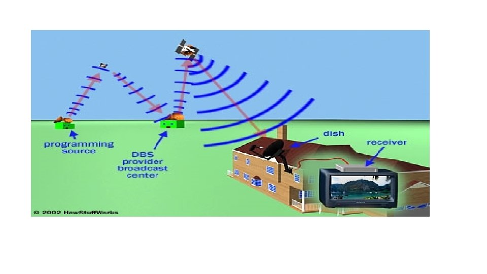
Direct Broadcast satellites (DBS) üSatellites provide broadcast transmissions in the fullest sense of the word, because antenna footprints can be made to cover large areas of the earth. üThe idea of using satellites to provide direct transmissions into the home has been around for many years, and the services pro- vided are known generally as direct broadcast satellite (DBS) services. üBroadcast services include audio, television, and Internet services.
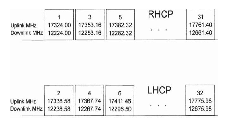
Power Rating and Number of Transponders • satellite will be seen that satellites primarily intended for DBS have a higher [EIRP] than for the other categories, being in the range 51 to 60 d. BW. • At a Regional Administrative Radio Council (RARC) meeting in 1983, the value established for DBS was 57 d. BW. • Transponders are rated by the power output of their high-power amplifiers. • Typically, a satellite may carry 32 transponders. • If all 32 are in use, each will operate at the lower power rating of 120 W. • The available bandwidth (uplink and downlink) is seen to be 500 MHz. • A total number of 32 transponder channels, each of bandwidth 24 MHz, can be accommodated. • The bandwidth is sometimes specified as 27 MHz, but this includes a 3 MHz guardband allowance. Therefore, when calculating bit-rate capacity, the 24 MHz value is used. • The total of 32 transponders requires the use of both right- hand circular polarization (RHCP) and left-hand circular polarization (LHCP) in order to permit frequency reuse, and guard bands are inserted between channels of a given polarization.
Bit Rates for Digital Television • The bit rate for digital television depends very much on the picture format. • One way of estimating the uncompressed bit rate is to multiply the number of pixels in a frame by the number of frames per second, and multiply this by the number of bits used to encode each pixel.
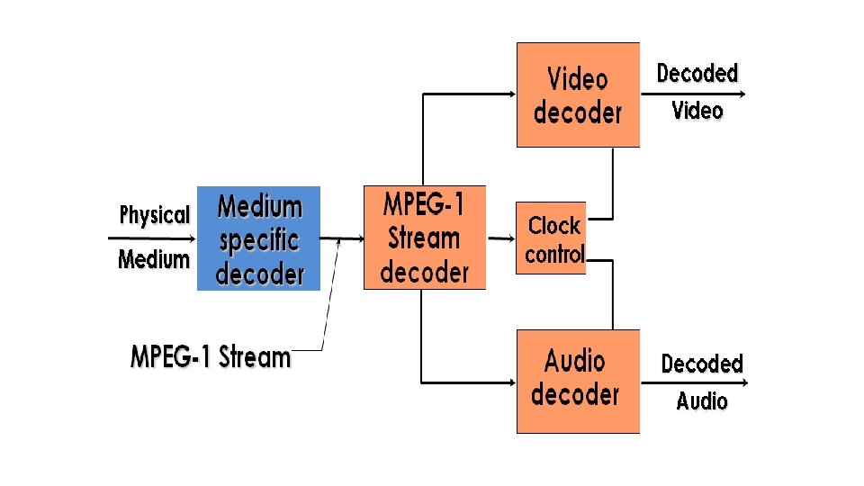
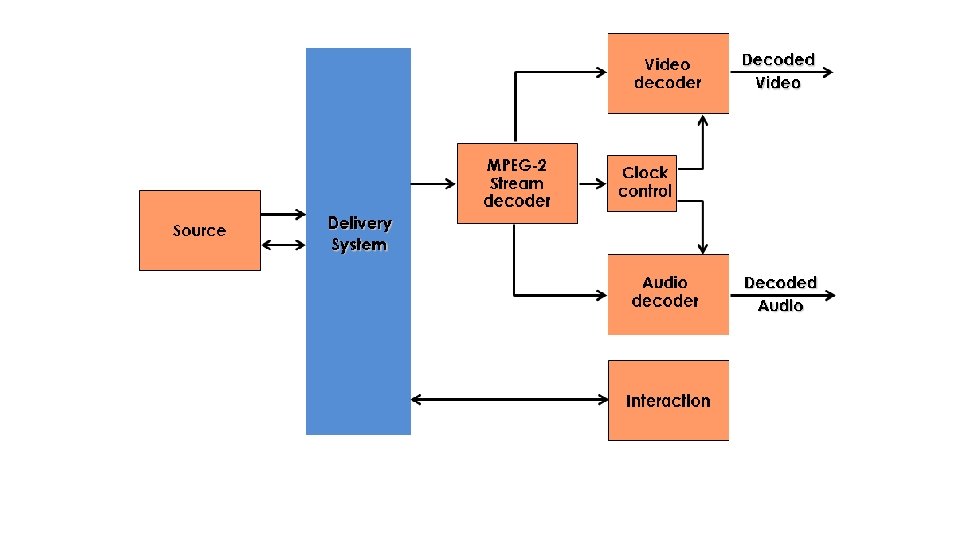
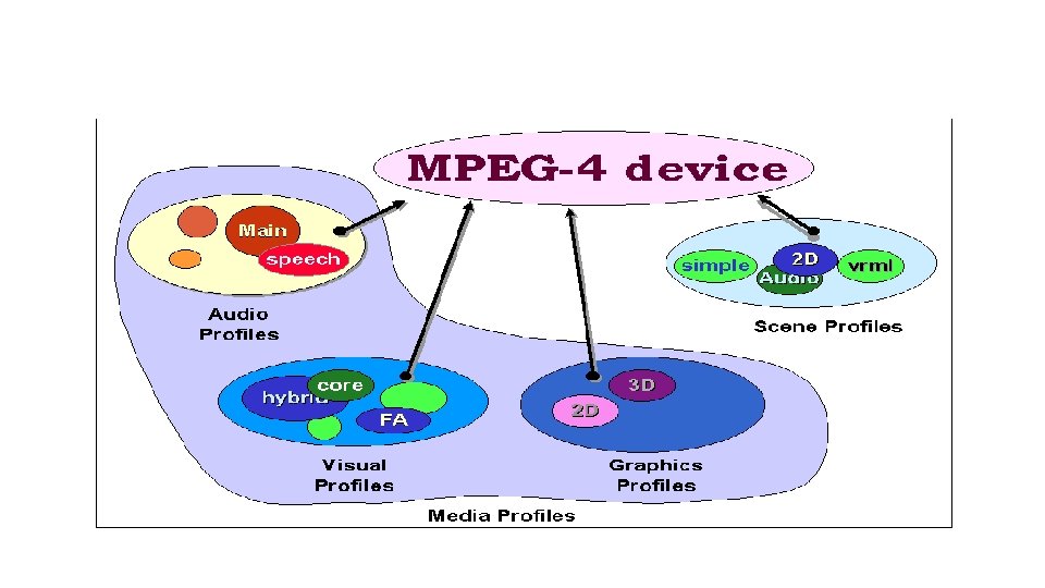
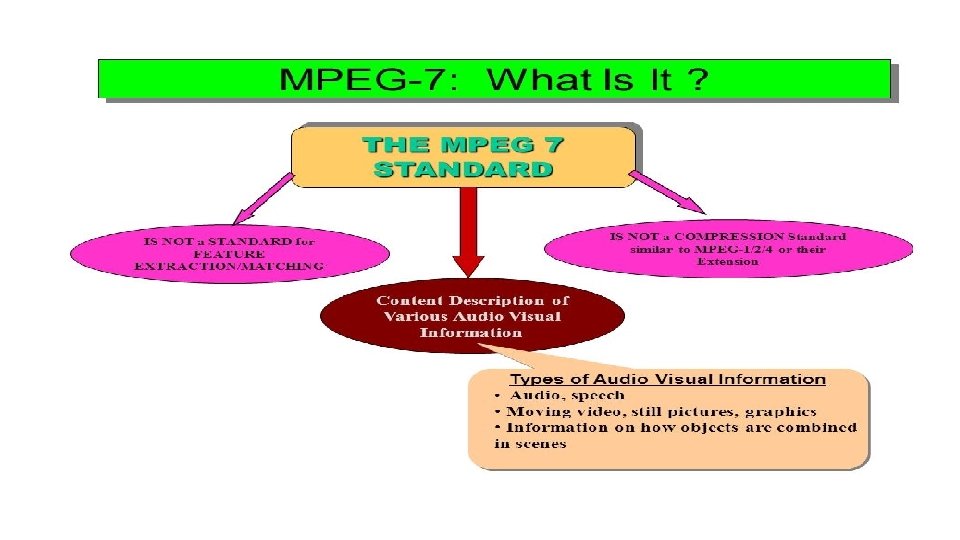
MPEG Compression Standards • MPEG is a group within the International Standards Organization and the International Electrochemical Commission (ISO/IEC) that undertook the job of defining standards for the transmission and storage of moving pictures and sound. • The MPEG standards currently available are MPEG-1, MPEG-2, MPEG 4 , and MPEG-7.
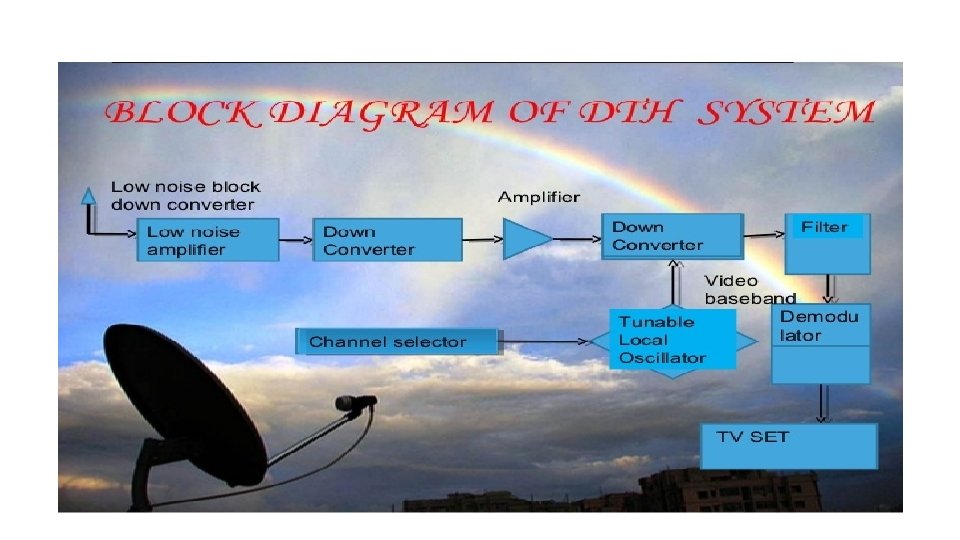
Direct to home Broadcast (DTH) üDTH stands for Direct-To-Home television. DTH is defined as the reception of satellite programmes with a personal dish in an individual home. üDTH Broadcasting to home TV receivers take place in the ku band(12 GHz). üThis service is known as Direct To Home service. üDTH services were first proposed in India in 1996. üFinally in 2000, DTH was allowed. üThe new policy requires all operators to set up earth stations in India üwithin 12 months of getting a license. DTH licenses in India will cost $2. 14 million and will be valid for 10 years. üWorking principal of DTH is the satellite communication. Broadcaster modulates the received signal and transmit it to the satellite in KU Band from satellite one can receive signal by dish and set top box.
DTH Block Diagram
üA DTH network consists of a broadcasting centre, satellites, encoders, multiplexers, modulators and DTH receivers üThe encoder converts the audio, video and data signals into the digital format and the multiplexer mixes these signals. üIt is used to provide the DTH service in high populated area A Multi Switch is basically a box that contains signal splitters and A/B switches. ü A outputs of group of DTH LNBs are connected to the A and B inputs of the Multi Switch.
DTH: Advantage üDTH also offers digital quality signals which do not degrade the picture or sound quality. üIt also offers interactive channels and program guides with customers having the choice to block out programming which they consider undesirable üOne of the great advantages of the cable industry has been the ability to provide local channels, but this handicap has been overcome by many DTH providers using other local channels or local feeds. üThe other advantage of DTH is the availability of satellite broadcast in rural and semi-urban areas where cable is difficult to install.
DAB
Digital audio broadcast (DAB) üDAB Project is an industry-led consortium of over 300 companies üThe DAB Project was launched on 10 th September, 1993 üIn 1995 it was basically finished and became operational üThere are several sub-standards of the DAB standard o DAB-S (Satellite) – using QPSK – 40 Mb/s o DAB-T (Terrestrial) – using QAM – 50 Mb/s o DAB-C (Cable) – using OFDM – 24 Mb/s üThese three sub-standards basically differ only in the specifications to the physical representation, modulation, transmission and reception of the signal. üThe DAB stream consists of a series of fixed length packets which make up a Transport Stream (TS). The packets support ‘streams’ or ‘data sections’. üStreams carry higher layer packets derived from an MPEG stream & Data sections are blocks of data carrying signaling and control data. üDAB is actually a support mechanism for MPEG. & One MPEG stream needing higher instantaneous data can ‘steal’ capacity from another with spare capacity.
World space services üWorld. Space (Nasdaq: WRSP) is the world's only global media and entertainment company positioned to offer a satellite radio experience to consumers in more than 130 countries with five billion people, driving 300 million cars. üWorld. Space delivers the latest tunes, trends and information from around the world and around the corner. üWorld. Space subscribers benefit from a unique combination of local programming, original World. Space content and content from leading brands around the globe, including the BBC, CNN, Virgin Radio, NDTV and RFI. World. Space's satellites cover two-thirds of the globe with six beams. üEach beam is capable of delivering up to 80 channels of high quality digital audio and multimedia programming directly to World. Space Satellite Radios anytime and virtually anywhere in its coverage area. ü World. Space is a pioneer of satellite-based digital radio services (DARS) and was instrumental in the development of the technology infrastructure used today by FM Satellite Radio. .
World space services
Business Television (BTV) - Adaptations for Education ü Business television (BTV) is the production and distribution, via satellite, of video programs for closed user group audiences. ü It often has two-way audio interaction component made through a simple telephone line. It is being used by many industries including brokerage firms, pizza houses, car dealers and delivery services. ü BTV is an increasingly popular method of information delivery for corporations and institutions. ü Private networks, account for about 70 percent of all BTV networks. It is estimated that by the mid-1990 s BTV has the potential to grow to a $1. 6 billion market in North America with more and more Fortune 1 , 000 companies getting involved. The increase in use of BTV has been dramatic. ü Institution updates, news, training, meetings and other events can be broadcast live to multiple locations. The expertise of the best instructors can be delivered to thousands of people without requiring trainers to go to the site ü Information can be disseminated to all employees at once, not just a few at a time. Delivery to the workplace at low cost provides the access to training that has been denied lower level employees. It may be the key to retraining America's work force. ü Television has been used to deliver training and information within businesses for more than 40 years. ü Its recent growth began with the introduction of the video cassette in the early 1970 s. Even though most programming is produced for video cassette distribution, business is using BTV to provide efficient delivery of specialized programs via satellite.
ü The advent of smaller receiving stations - called very small aperture terminals (VSATs) has made private communication networks much more economical to operate. ü BTV has a number of tangible benefits, such as reducing travel, immediate delivery of timecritical messages, and eliminating cassette duplication and distribution hassles. ü The programming on BTV networks is extremely cost-effective compared to seminar fees and downtime for travel. ü It is an excellent way to get solid and current information very fast. Some people prefer to attend seminars and conferences where they can read, see, hear and ask questions in person. ü BTV provides yet another piece of the education menu and is another way to provide professional development. ü A key advantage is that its format allows viewers to interact with presenters by telephone, enabling viewers to become a part of the program. The satellite effectively places people in the same room, so that sales personnel in the field can learn about new products at the same time. ü Speed of transmission may well be the competitive edge which some firms need as they introduce new products and services. ü BTV enables employees in many locations to focus on common problems or issues that might develop into crises without quick communication and resolution. ü BTV networks transmit information every business day on a broad range of topics, and provide instructional courses on various products, market trends, selling and motivation. Networks give subscribers the tools to apply the information they have to real world situations.
GRAMSAT
GRAMSAT üISRO has come up with the concept of dedicated GRAMSAT satellites, keeping in mind the urgent need to eradicate illiteracy in the rural belt which is necessary for the all round development of the nation. üThis Gramsat satellite is carrying six to eight high powered C-band transponders, which together with video compression techniques can disseminate regional and cultural specific audio-visual programmes of relevance in each of the regional languages through rebroadcast mode on an ordinary TV set. üThe high power in C-band has enabled even remote area viewers outside the reach of the TV transmitters to receive programmers of their choice in a direct reception mode with a simple. dish antenna.
features of GRAMSAT v. Its communications networks are at the state level connecting the state vcapital to districts, blocks and enabling a reach to villages. v. It is also providing computer connectivity data broadcasting, TVvbroadcasting facilities having applications like e- governance, development information, teleconferencing, helping disaster management. v. Providing rural-education broadcasting. v. However, the Gramsat projects have an appropriate combination of following activities. v. Interactive training at district and block levels employing suitable configuration v. Broadcasting services for rural development v. Computer interconnectivity and data exchange services v. Tele-health and tele-medicine services.
Specialized services Satellite-email services: üThe addition of Internet Access enables Astrium to act as an Internet Service Provider (ISP) capable of offering Inmarsat users a tailor-made Internet connection. üWith Internet services added to our range of terrestrial networks, you will no longer need to subscribe to a third party for Internet access (available for Inmarsat A, B, M, mini-M, Fleet, GAN, Regional BGAN & SWIFT networks). üWe treat Internet in the same way as the other terrestrial networks we provide, and thus offer unrestricted access to this service. There is no timeconsuming log-on procedure, as users are not required to submit a user-ID or password.
Description of E-mail Service: • Astrium's E-Mail service allows Inmarsat users to send and receive e-mail directly through the Internet without accessing a public telephone network. Features and Benefits • No need to configure an e-mail client to access a Astrium e-mail account • Service optimized for use with low bandwidth Inmarsat terminals • Filter e-mail by previewing the Inbox and deleting any unwanted e-mails prior to downloading • No surcharge or monthly subscription fees • Service billed according to standard airtime prices for Inmarsat service used
Video Conferencing
Video Conferencing (medium resolution) v. Video conferencing technology can be used to provide the same full, twoway interactivity of satellite broadcast at much lower cost. v For Multi-Site meetings, video conferencing uses bridging systems to connect each site to the others. v. It is possible to configure a video conference bridge to show all sites at the same time on a projection screen or monitor. v. Or, as is more typical, a bridge can show just the site from which a person is speaking or making a presentation. v. The technology that makes interactive video conferencing possible, compresses video and audio signals, thus creating an image quality lower than that of satellite broadcasts.
Satellite Internet access üSatellite Internet access is Internet access provided through communications satellites. ü Modern satellite Internet service is typically provided to users through geostationary satellites that can offer high data speeds, with newer satellites using Ka band to achieve downstream data speeds up to 50 Mbps. üSatellite Internet generally relies on three primary components: a satellite in geostationary orbit ( sometimes referred to as a geosynchronous Earth orbit, or GEO), a number of ground stations known as gateways that relay Internet data to and from the satellite via radio waves (microwave), and a VSAT (verysmallaperture terminal) dish antenna with a transceiver, located at the subscriber's premises. üOther components of a satellite Internet system include a modem at the user end which links the user's network with the transceiver, and a centralized network operations center ( NOC) for monitoring the entire system