The characteristics of and changes in land use


- Slides: 55

The characteristics of, and changes in, land use in urban areas: case study HOUSTON Objective: To find out how urban areas are structured in terms of land use and how this is changing in modern times.


Houston in 1955

Houston today

Changing urban models in MEDCs L/O: To recognise land use models and be able to compare them and apply them to ONE MEDC. What do these show us? Can you connect these models to Houston ?

Think – land use! • How is land used in an urban area? • List what sorts of ways land could to be used in an urban area? E. g. offices Commercial: Residential: Industrial: Agricultural: Recreational: Retail: Educational: This is businesses, This is housing and This is factories, This farming and is Any activity that This is shops. Any building mainly offices. The is where people traditionally found obviously normally people do in their Traditionally the connected to main commercial live. Apartment in the transition found in rural areas spare time. This main shopping education e. g. area will normally type housing is zone, they are now although some land use may areas have been in libraries, schools be in the CBD. found near the more likely to be cities may have include golf the CBD but and universities. CBD and bigger found in the rural- some small urban courses, football increasingly shops This land use may houses towards urban fringe. farms. pitches, museums, have been be found anywhere the suburbs. sports centres and relocating to in urban areas. tennis courts. shopping malls in the rural-urban fringe.

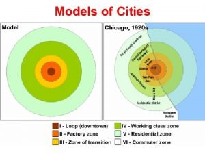
Land use models in a MEDC Land use models are theories that attempt to give a pattern to the land use in most cities. The concentric model was created by Ernest Burgess and is based on Chicago, where he claims all settlements start from an central point going outwards. As you move out from the CBD (central business district) the higher the income of the average person becomes. The centre (CBD) is usually the oldest part of the city however it should be also the most advanced and as the needs of the CBD grows the city will also grow in all directions. The yellow area is High class residential, this means that they are usually fully detached (not attached to another house) and are biggest, and usually containing a garden. The low class residential area is the area most close to the factories, the housing will usually be attached on both sides (detached) and very small and closely packed when compared to the high class residential. This is to put more people in a smaller area. So workers can get to their jobs easier (in the factories)

Land use models in a MEDC Land use models are theories that attempt to give a pattern to the land use in most cities. This model was based on the land use in cities before public transport. This means that factories had to be placed along rivers or railway lines which could be used transport of raw materials into the manufactured good out of the city. They were also in the centre close to lots of workers ( a large work force) Features of a CBD: high density of people and buildings (there are lots of them close together), offices, businesses, expensive land, oldest part, small alleys and medieval streets, perhaps pedestrianised (no cars can drive there. )

Hoyt model The sector (Hoyt) was created by Hoyt and was created after the introduction of public transport so that workers can live further away from work and still get there quickly, this also means that buses and trains can get around the city helping people get around the city. Roads help vans and lorries get into manufacturing areas bringing raw materials and out of the areas bringing manufactured goods from the factories and into the shops. Factories can now be built outside the city

Features of Houston’s CBD

All the major freeways in Houston lead to Downtown- this makes is the most accessible part of the city. Downtown Houston has many tall buildings. This is because of the high cost of land so buildings need to build upwards rather than outwards to save space. There are many TNC headquarters located in the CBD like Chevron and BG group because they are the ones that can afford the high cost of the land (many are oil and gas companies due to Houston’s proximity to to the Gulf of Mexico. The environmental quality in the CBD is generally high as the companies here want to to be attractive to their customers- parks (such as Discovery Green) have been created to keep the environmental quality high. There are many services that will be used by the whole city such as city hall and the main justice courts for the city. There is not shopping in Downtown Houston- this has located in more easily accessible malls in the suburbs.

The Rural-Urban Fringe Rural-urban fringe: The boundary between the urban area (towns and cities) and the rural area (countryside). Because so many cities are expanding, more houses need to built and often this means building on greenfield sites and the rural urban fringe. This means different groups frequently come into conflict over how to use it. Groups that may come into conflict include: House developers House buyers Farmers Hikers and cyclists Road builders Factories Supermarkets Business or science parks

Key Word Definitions: A brownfield site is land that has been used, abandoned and now awaits some new use. Commonly found across urban areas, particularly in the inner city. A greenfield site is a plot of land, often in a rural or on the edge of an urban area that has not yet been subject to any building development. https: //www. youtube. com/watch? v=UDcd. FJc 5 G 9 M&list=PLn. Hzp 8 tnpt. FXp. Kags 1 hvgv. Gk. Sg. YCk. Jj. Y 7

Task: Sort the cards into two categories. Advantages of building on a brownfield site and advantages of building on a greenfield site. Challenge: Which of the two sites to build on do you think benefits: a) The developer. b) The potential residents of the new homes. More space for gardens. Roads already exist. Easier to get planning permission Pleasant countryside environment as councils want to see brownfield may appeal to potential home sites used. owners. Land cheaper on the outskirts so plots can be larger. Sites in cities are not left derelict and/or empty. Near to facilities in town centres, No restrictions of existing road e. g. shops, entertainment and network. places of work. Some shops and business parks on Utilities such as water and the outskirts provide local electricity are already provided. facilities. Cuts commuting. New sites do not need clearing so can be cheaper to prepare.

Developing the rural urban fringe Imagine a shopping centre was being built on the outskirts of Houston there would be advantages and disadvantages for the local residents! ADVANTAGES TO LOCAL RESIDENTS IN RURAL -URBAN FRINGE • New public transport links may be developed DISADVANTAGES TO LOCAL RESIDENTS IN RURAL-URBAN FRINGE • There will be an increase in congestion as more people travel to shopping centre by car. • There will be new facilities that local residents can access and use • The shopping centres may create noise, air and visual pollution all affecting local residents • Local residents may get jobs in the new (negative externality) shopping centre. • Shopping centres may destroy greenfield sites • The shopping centre may pull more people that have previously been used and enjoyed by into the area and may benefit existing services, local residents. possibly owned by local residents (positive multiplier effect).

The location of Memorial Mall, Houston

Why is shopping moving to the suburbs? Skill: annotate this image to explain why memorial has located in the suburbs

Excellent transport links. I 10 Away from city centre so more land available for cheaper parking and bigger stores Near wealthy residential areas in the West of Houston such as Memorial and Lakes and Eldridge

Case Study: The location of retail- i. e. Memorial, Houston Explain the factors that affect the location of tertiary industry. Use an example in your answer. (6)

Explain the factors that affect the location of tertiary industry. Use an example in your answer. (6) Memorial shopping Mall is part of the retail industry. It is located in an suburban area of Houston, Texas. It is a very large mall with ? square feet of space; a location within the suburbs was therefore appropriate as land is cheaper than in the CBD. An important consideration for the retail industry is accessibility for customers and deliveries of merchandise. The mall is located just off the I 10 – a major arterial route of the e city; this enables large numbers of people to reach the mall easily. It is an upscale mall and so it is located in the west of the city; this is a wealthier area of the city and so customers have ample disposable income to spend. The location of the mall in the suburbs means that there are many people living in residential areas surrounding the mall providing both workers and customers. The area surrounding the Memorial is multiuse; there are many offices in the area increasing the consumer base still further.

Task 1 - google maps to try and apply the Burgess and Hoyt model to Houston • Using google maps…. • Compete the table using google street mapview to find evidence of different land use zones within Houston and desecribe the evidence Task 2: Transfer this information onto the wall map of Houston to make a display. Things to include: Images of different areas of Houston- and an explanation of why the land use is different in each of these areas Key terms associated with the land use maps (CBD/ inner city/ Suburbs/ industy/ low class residential/ high class residential/ rural-urban fringe) Success criteria: make the display detailed and informative but also readable and attractive

Land use in Houston- annotate a map to show and explain the land use in Houston, Tx

Downtown Houston (the CBD) is in the center of the city with the greatest accessibility- different to theory there is no shopping located in Houston’s CBD Newer, larger, high class houses in the outer suburbs (such as Katy)- here there is more land available- this conforms to theory Sh In Houston shopping tends be located in suburban areas (i. e. Memorial Mall) where there is good road access, more space and closer to the customers Houston is a good example of urban sprawl On the Eastern Inner city there are poorer neighborhoods such as the third ward- smaller houses and ethnic divides Industrial developments on the East of the city along In Houston some of the canal and wealthiest residential areas (i. e. the 1 -10 River Oaks) are located in the freeway for inner city area- this differs accessibility. from theory on the model Good access needed to oil In Houston there is a general West/ east divide in terms of quality of life (West in the Gulf of having higher quality of Life) Mexico

Exam question

Named city: Houston, Tx Houston is a city that has experienced Urban sprawl and this has impacted it’s morphology. Downtown Houston (the CBD) does lie in the center of the city and has many of the characteristics you would expect of a CBD such as high rise buildings and offices. The CBD of Houston does not have shopping as a main land use- in Houston this is located in the suburbs (i. e. Memorial mall) due to closer access to transport links (the I 10), more space for building and accessibility to the population. Industry is located on the East of the city along transport routes (such as the I 10 and canal) similar to the Hoyt model. Large, higher class residential homes have developed on the edge of the city (i. e. in Katy) similar to the Burgess model. There is an east, west divide in terms of quality of life in Houston with the Eastern inner city having smaller, poorer homes (i. e. the Third Ward), but also some of the richest mansions (in River Oaks) on the Western inner city which is a land use that differs from the model.

1. 7 Urbanisation Learning objectives: • Explain the problems of urban areas, their causes and possible solutions What we need to know: Different types of pollution (air, noise, water, visual), inequality, housing issues, traffic congestion and conficts over land use change

Google timelapse shows changing earth • https: //www. theguardian. com/environment/video/2016/dec/05/evo lving-earth-captured-by-google-timelapse-video

Key term: urban sprawl

Question: 1. Describe the pattern shown on this graph (3)

Brownfield- A site that has been built on before. Normally associated with urban areas. Greenfield- Sites that have not been built on before. Often rural / countryside areas. As a decision maker you are faced with two options: 1. Develop existing Brownfield sites 2. Develop new Greenfield sites Complete the worksheet to find out the positives and negatives of brownfield and greenfield sites

Urban sprawl

How do each of these lead to urban/suburban sprawl

1. Expanding the outer suburbs = urban sprawl Advs Near the countryside for leisure, plenty of space, not too far to commute to CBD for work, the construction out of town shopping centres means that there are often plentiful services nearby. Disadvs Involves building on greenfield sites which means the loss of countryside e. g. for leisure purposes/habitats for animals. Results in high dependence of the car to move around the sprawl e. g. for shopping, schools and to get to the commuter train.

General theory: A number of problems are associated with the growth of urban areas. These include: • Congestion in the CBD • Very high land prices in the CBD • Overcrowding • Housing shortages • Traffic congestion • Unemployment • Racial conflict • Urban decay and dereliction • Deprivation • Pollution of air and water

Discuss: What are the benefits and problems of urban sprawl in Houston?

Urban sprawl in Houston Benefits • Large houses/ gardens etc (high quality of living) • Cheap land= cheaper houses • Development of industry Issues • Car dependent- cannot develop public transport systems • A lot of greenspace lost due to development on Greenfield sites • Risk of flooding increased- due to increased urbanisation • Long commute times and • Increase in illnesses such as diabetes due to being car dependent • Inequality

For a named urban area you have studied, describe the problems which are caused by urban sprawl (7) Because of no planning restrictions or space restrictions Houston has uncontrollably spread onto the greenspace surrounding it. This has lead to over-reliance on the car. Many commuters are travelling 30 -40 miles a day each way to get to work (i. e. from the suburb of Katy to Downtown Houston) . This leads to many cars on the road (the main freeway running through Houston, the i 10 is the widest in the world) and so there is large amounts of air pollution. The heavy reliance on the car means that many people live sedentary lifestyles so there is a high prevalence of diseases such as diabetes and obesity. The urban sprawl has meant that many greenspaces have been lost. The site of Houston was orginally swamp land which would have absorbed all of the rainfall. This has increased the risk of flooding because of increased run-off such as during hurricanes such as Harvey.

Exam question practice: The building of new housing, roads and services often results in urban sprawl. Name an example of a town or city which you have studied where urban sprawl has taken place. Describe its effects on people and the natural environment. [7]

Solutions to Urban sprawl Managing Urban Transport LO: Explain the management of transport in urban areas and evaluate how this reduces urban sprawl

Recap: Think, pair share • What do you think are the 3 biggest issues of urban sprawl • Is this the same in all cities?

Question: 1. Describe the pattern shown on this graph (3)

Bike share schemes e. g. Barclay’s Bikes, London Velib, Paris, B-Cycle, Houston Barclay’s Bikes, London: http: //www. youtube. com/watch? v=p 6 t 7 Oq. R 73 AA https: //www. youtube. com/watch? v=Eg. IPGx 02 VKc B-Cycle, Houston: http: //www. youtube. com/watch? v=_is. WKKs 5 k. HY http: //www. youtube. com/watch? v=7 JUDUl. ZV 5 Vk

Houston B-Cycle • • Houston B-cycle is a bicycle sharing system owned and operated by Houston Bike Share a non-profit organisation. The program launched May 2012 with just 18 bikes at 3 stations. May 2013, Houston B-cycle expanded from 3 to 25 stations and 215 bikes. The program aims to expand to 1, 000 bikes at 100 stations by the end of 2017 to include the Texas Medical Center and local universities, as well as additional neighborhoods such as Houston Heights, Midtown and Montrose.

• • Houston B-cycle is a bicycle sharing system owned and operated by Houston Bike Share a non-profit organisation. The program launched May 2012 with just 18 bikes at 3 stations. May 2013, Houston B-cycle expanded from 3 to 25 stations and 215 bikes. The program aims to expand to 1, 000 bikes at 100 stations by the end of 2017 to include the Texas Medical Center and local universities, as well as additional neighborhoods such as Houston Heights, Midtown and Montrose.

Map of BCycles in Houston

Evaluation • Why may a bike scheme work better in London than Houston. • List at least 3 points.

Bike sharing schemes Work best in compact (high density cities) such as those in Europe e. g. London and Paris) Houston has adopted its own bike sharing scheme but it is much more limited in its extent as it is a low density city

Park and ride Houston Direct nonstop service to downtown, the Texas Medical Center and other major employment centers in the METRO service area is available from Park & Ride lots. Park & Ride facilities also serve as a staging area for vanpools and carpools.

Sustainable Transport Houston • • In cities such as Houston, Texas creating a sustainable public transport network is a problem as the city has sprawled rapidly outwards, occupying a total land area of 650 square miles. Many sustainable transport solutions therefore rely on the continued use of private vehicles. The city’s freeways also offer HOV (High occupancy vehicle lanes) to try to encourage car pooling to decrease Co 2 levels through fewer vehicles on the road.

Houston HOV

Need a car for a few hours near Houston, TX? Zipcar is an alternative to car rental and car ownership. It's a car, but only when you need one. Check out the map below. Enter an address, zip code, or neighborhood to find Houston, TX Zipcars. http: //www. bing. com/videos/se arch? q=what%20 is%20 zipcar&q s=n&form=QBVR&pq=what%20 i s%20 zipcar&sc=6 -14&sp=1&sk=#view=detail&mid=AE 5 D 3 460 CAE 6905 A 53 B 3 AE 5 D 3460 CA E 6905 A 53 B 3 http: //www. bing. com/videos/searc h? q=what%20 is%20 zipcar&qs=n&fo rm=QBVR&pq=what%20 is%20 zipcar &sc=6 -14&sp=1&sk=#view=detail&mid=BD 79666 A 8 EE 62 CD 32717 BD 79666 A 8 EE 62 CD 3 2717

Exam Question Outline how transport is being managed in urban areas. Explain how this reduces some of the negative impacts of urban sprawl (6)

For a town or city you have studied describe what has been done to manage urban sprawl (7) In Houston traffic is a major issue because of of uncontrolled urban sprawl. Many commuters are travelling 30 -40 miles a day each way to get to work. To manage this many park and ride areas have been developed in the suburb areas such as Katy. This tries to reduce the amount of the cars on the road. Additionally, HOV (high occupancy vechile) lanes have been created on the main freeways to allow cars with more than one passenger in them are allowed to travel into the city more quickly. Near the city centre a shared bicycle scheme (b-cycles) has been developed to the city centre to encourage people to take bikes rather than cars. This can reduce the impact of air pollution and wasted productivity time. Urban sprawl has increased the risk of flooding because of removal of the absorbative swamp land increased with urban surfaces that increased run off. To do this wetlands on the edge of the city, such as Katy Prarie, have been developed to preserve absorb the heavy rainfall.

Outline how transport is being managed in urban areas. You should refer to a number of different sustainable schemes in your answer. (6) • There a number of different ways to combat urban transport problems that arise from urban sprawl e. g. poor air quality and emission levels, congestion and accidents. The congestion charging zone in London is a scheme that aims to address these problems. It charges private cars a fee of 10 pounds to visit the city during peak times (7 am-6 pm Mon-Fri). This has reduced traffic in central London by 21% and the funds raised from congestion charging are being used to further improve public transport. These schemes can be seen as sustainable as they are limiting the impact that transport emissions could have on climate change that may impact on current and future generations.

 Characteristics of land use in urban areas
 Changes in latitudes, changes in attitudes meaning
 Physical change
 Changes in the land chapter 5 summary
 What are landforms
 Identify the landform
 St. marys county land use and zoning lawyer
 Characteristics of a well-prepared upland field
 Whales use to walk on land
 Sector model theory
 City zones
 Land use planning lecture notes
 Land use certificate hyderabad
 Usgs land use classification
 Types of land use
 Mixed land use ap human geography definition
 Bid-rent theory ap human geography
 Irrevocable rights to some limited use of another's land
 Von thunen's agricultural land use model
 Which use of western land negatively affected everyone?
 Land use planning '' lecture notes
 Flood hazard area land use management guidelines
 Von thunen agricultural land use model
 Vdot ssar
 Land use planning '' lecture notes
 Transportation
 Multiple nuclei model example
 What is the meaning of land use
 Zone of transition
 Define land use planning
 Weber model ap human geography
 Von thunen model of agricultural land use
 Hình ảnh bộ gõ cơ thể búng tay
 Ng-html
 Bổ thể
 Tỉ lệ cơ thể trẻ em
 Gấu đi như thế nào
 Chụp phim tư thế worms-breton
 Alleluia hat len nguoi oi
 Các môn thể thao bắt đầu bằng tiếng đua
 Thế nào là hệ số cao nhất
 Các châu lục và đại dương trên thế giới
 Công thức tính thế năng
 Trời xanh đây là của chúng ta thể thơ
 Cách giải mật thư tọa độ
 Làm thế nào để 102-1=99
 Phản ứng thế ankan
 Các châu lục và đại dương trên thế giới
 Thơ thất ngôn tứ tuyệt đường luật
 Quá trình desamine hóa có thể tạo ra
 Một số thể thơ truyền thống
 Cái miệng xinh xinh thế chỉ nói điều hay thôi
 Vẽ hình chiếu vuông góc của vật thể sau
 Biện pháp chống mỏi cơ
 đặc điểm cơ thể của người tối cổ
 Thế nào là giọng cùng tên?
