Chapter 14 Land Land Use and Land Cover


- Slides: 51
Chapter 14 Land
Land Use and Land Cover Land use Ex. Farming, mining, cities, highways, recreation Land cover - different types of land cover depending on the use.
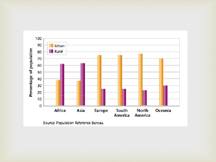
Land Use and Land Cover Urban - Land covered mainly with buildings and roads 2, 500 or more people and a governing body Rural - Relatively few people and large areas of open space
Where We Live Until 1850 most people lived in rural areas The industrial revolution changed this Machinery on farms requires fewer people Better transportation allowed manufacturers to be far from their customers People moved to cities to find jobs Urban areas grew rapidly during the 20 th century. Most people now live in urban areas.
• Developed Countries: each person uses the ecosystem services provided by about 8 hectares (20 acres) of land water. • US: each person uses 12 hectares (30 acres) • Germany: 6 hectares (15 acres) • Developing Countries: people may not have access to all the resources for a healthy life. They may use less than 1 hectare (2. 5) person.
Do Now: skip #2
The Urban-Rural Connection People are dependent on resources produced in rural areas. Ecosystem services - resources produced by natural and artificial ecosystems.
Supporting Urban Areas The area of rural land needed to support one person depends on Climate, standard of living, how efficiently resources are used Each person in a developed country uses 8 hectares (20 acres) of ecosystem services Each person in the United States uses more than 12 hectares of ecosystem services. Most people in developing countries use less than a hectare of ecosystem services. Lack access to resources for a healthy life.
Urbanization - movement of people from rural areas to cities. Usually leave rural areas for better paying jobs
The Urban Crisis Urban crisis - More people live in a city than its infrastructure can support Infrastructure- all of the things that a society builds for public use Ex. Roads, sewers, railroads, bridges, police, fire stations, power lines…. . Rapid urban growth leads to trouble Overwhelm the infrastructure Ex. Traffic jams, substandard housing, polluted air and water Living conditions deteriorate
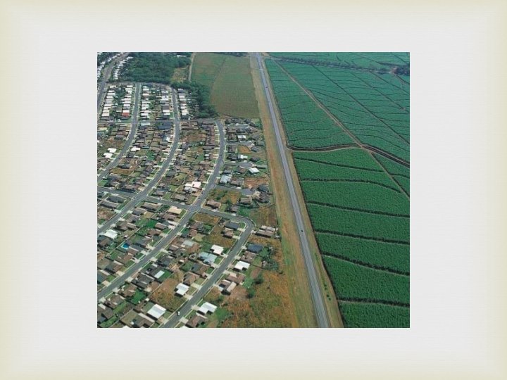
Urban Sprawl Urban sprawl - rapid expansion of a city into the countryside around the city. Results in the building of suburban communities (suburbs) Most suburbs are built on land that was used for farming Most Americans live in the suburbs Each year suburbs spread over another million hectares (2. 5 million acres)
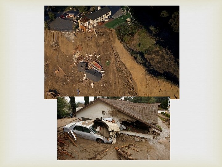
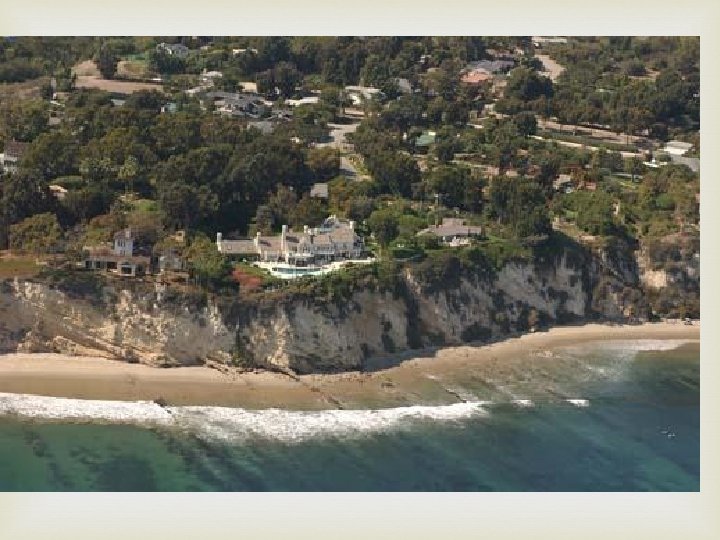
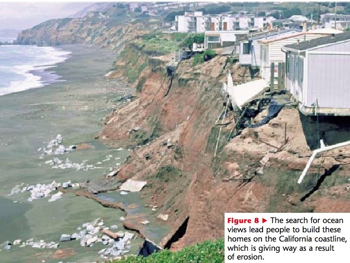
Development on Marginal Lands Marginal land - land that is poorly suited for building Many cities were first built in areas where there was little room for expansion. Suburbs were often built on marginal lands Example: The suburbs of Los Angeles and Mexico City expanded into the surrounding mountains which are prone to mudslides
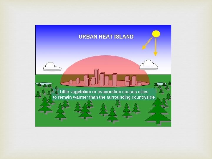
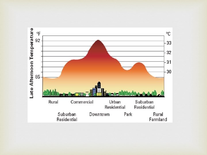
Other Impacts of Urbanization Cities generate and trap more heat than the countryside. Heat island - the increased temperature in the city. Concrete retains more heat than vegetation. Heat is generated by the infrastructure Heat islands affect local weather patterns Hot air rises and produces rain clouds.
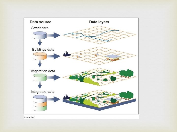
Urban Planning - Intelligent Design Land-use planning - determining in advance how land will be used Planners use geographic information systems Geographic information systems(GIS) computerized system for storing, manipulating, and viewing geographic data. The user enters information such as location of sewer lines, roads, houses and parks and then creates a map. Allows the uses to display layers of information.
Urban Planning Transportation Many U. S. cities were constructed after the invention of the automobile and sprawl over large areas. Difficult to get around without a car Heavy traffic Many cities in Europe were built before the invention of the automobile Narrow, compact roads
Manhattan vs. Florence
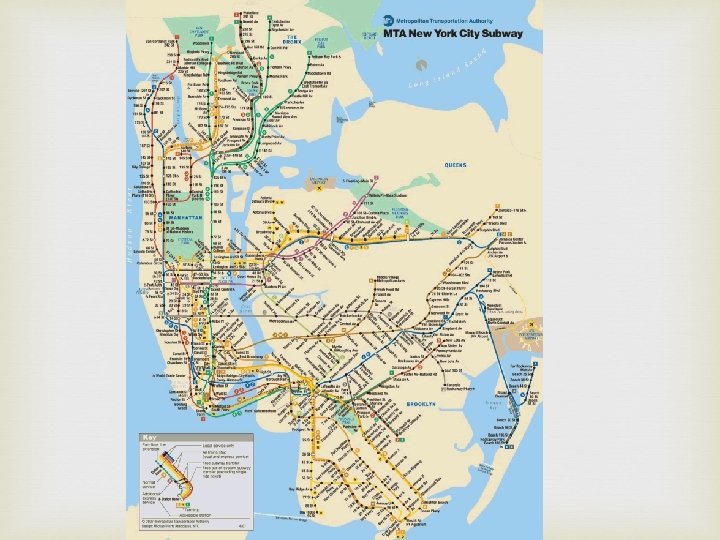
Urban Planning Transportation Mass Transit systems were constructed. Mass Transit - buses and trains move many people around the city. Save energy Reduce traffic Reduce air pollution Limit loss of land to roads and parking lots
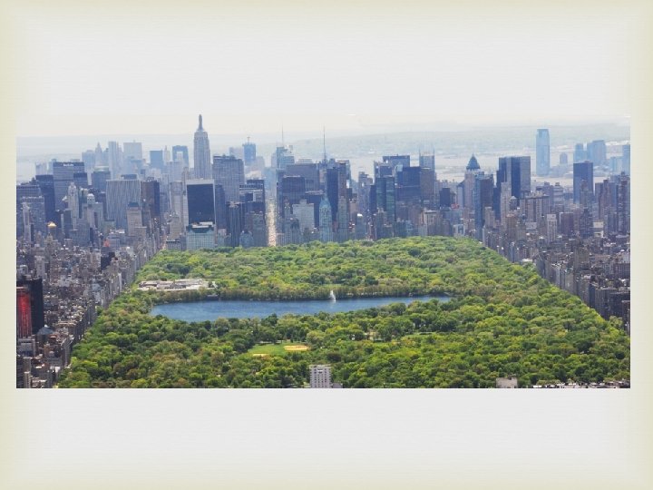
Urban Planning - Open Space Open space - land within urban areas that is set aside for scenic and recreational enjoyment. Parks, public gardens, bicycle and hiking trails. Greenbelts - open spaces left in their natural condition. Many benefits Absorb CO 2, Produce O 2, remove pollutants from the air, keep the city cooler, absorb rainwater, exercise and relaxation for urban residents.
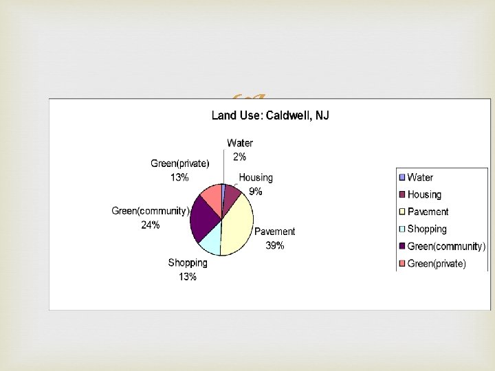
Land Management and Conservation The resources of more rural land are needed to support the growing population Rural land categories Farmland Rangeland Forest land National and state parks Wilderness Rural land is important for their ecological services
Farmlands Farmland - land that is used to grow crops and fruit. Farmland is threatened in many parts of the U. S. by land development
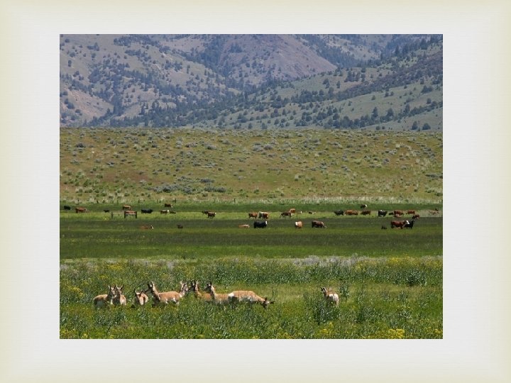
Rangelands Rangeland-land that supports different vegetation types that is not used for farming. Most commonly used for the grazing of livestock such as cattle, sheep and goat. World population growth may require a 40% increase in rangeland food production by 2030.
Problems on the Range Much of the rangeland is degraded Poor land management. Overgrazing - more animals graze than the area can support. Destroys the plant community Less desirable plants repopulate the area Most of the rangeland is owned by the federal government and leased to ranchers
Problems on the Range Public Rangelands Improvement Act of 1978 Intended to improve land management practices Sustaining the productivity of rangelands Limiting herd size Leave the land unused for a period of time Killing off invasive plants Planting native vegetation Fencing areas
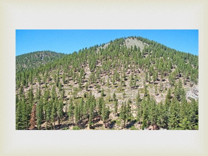
Forest Lands Ecosystem services provided by the forest Paper, wood, food, chemicals Removal of CO 2 is the most important Worldwide 1, 800 cm 3 of wood used person each day on average. Each person in the U. S. uses three times this amount on average. Equivalent to cutting down a 30 m tall tree every year
Forest Lands - Timber Industry Timber industry classifies forest into three categories Virgin forest - forest which has never been cut Native forest - forest that is planted and managed. Tree farms - trees are planted in rows and harvested like other crops
Forest Lands - Timber Industry Methods for harvesting trees Clear cutting - removing all of the trees from an area of land Destroys wildlife and causes soil erosion Selective cutting - cutting an removing only middle aged or mature trees. More expensive but less destructive
Clearcutting
Selective cutting
Forest Lands Deforestation - the clearing of trees from an them. area without replacing As the population grows deforestation increases. Increase in demand forest products Convert land into farmland Space for roads, factories and building Impacts Reduces wildlife Soil erosion Depletion of natural resource
Forest Lands Reforestation 90% of all timber comes from forests that are not monitored and managed by an agency. Reforestation - process by which trees are planted to re-establish trees that have been cut down. Replanting trees can reverse soil erosion Some governments require replanting of areas after timber has been harvested
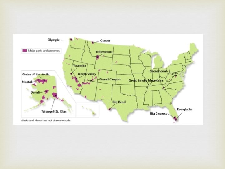
Parks and Preserves National parks protect land wildlife Yellowstone was the first national park created in the 1870 s. National parks are better protected than other public lands which can be leased and used for mining, ranching and logging. Some public lands are used to protect wildlife or an endangered species.
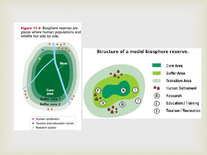
Parks and Preserves United Nation's Man and the Biosphere Program 1976 Established several hundred preserves throughout the world. Humans and wildlife are included in the plan and live side by side. Called biosphere reserves
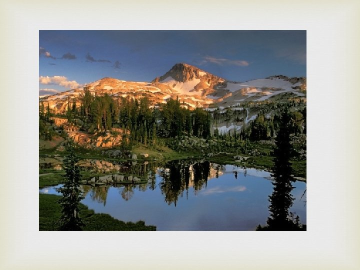
Parks and Reserves Wilderness - area in which the land the ecosystems it supports are protected from all exploitation. U. S. Wilderness Act - 1964 Designated certain lands as wilderness areas 32 million acres have been designated wilderness in the U. S. These areas are open to hiking, fishing, boating and camping No motorized equipment is allowed,
Parks and Preserves Benefits and Threats Benefits Protects species Protects habitats Recreation and education for people Threats Litter and traffic jams Climate change Rangelands, mining, logging, oil and gas drilling, power plants are close enough to affect the parks.