Chapter 22 Lecture Conceptual Integrated Science Second Edition



- Slides: 88

Chapter 22 Lecture Conceptual Integrated Science Second Edition Plate Tectonics © 2013 Pearson Education, Inc.

This lecture will help you understand: • The layered structure of the Earth • How seismic waves reveal Earth's internal structure • The concept of continental drift and how it led to theory of plate tectonics • How the motion of tectonic plates affects Earth's surface • Evidence for theory of plate tectonics • Differences among the three kinds of plate boundaries • How the process of subduction relates to volcanism and earthquakes © 2013 Pearson Education, Inc.

Earth Science Is an Integrated Science • A system is a collection of components that constantly affect one another. • Systems cannot be understood simply in terms of their individual parts. The way the parts work together and the emergent properties that arise from that interaction are also attributes of the system. • Earth is a system with living and nonliving parts that interact in tremendously complex ways. This is why Earth science is an integrated science. No one science discipline is sufficient to describe all of Earth's parts, processes, and properties. Physics, chemistry, biology, and astronomy all come into play. © 2013 Pearson Education, Inc.

• • Earth is a rocky sphere ¾ of it is covered by water A thin atmosphere (layer of gases) surrounds it Geology is the broadest Earth science discipline – Meteorology – study of weather – Petrology – study of rocks – Mineralogy – study of minerals within rocks – Paleontology – study of Earth’s early history – Oceanography – study of the oceans – Volcanology – study of volcanoes © 2013 Pearson Education, Inc.

Earth Has Distinct Compositional Layers • Earth has three basic layers: crust, mantle, and core. These layers differ in their chemical composition. • The crust is composed mainly of rocks that have minerals rich in silicon and oxygen. – Most common element in crust is oxygen. • Earth's crust is thin and cool overall but divided into basaltic oceanic crust and granitic continental crust. © 2013 Pearson Education, Inc.

Earth Has Distinct Compositional Layers • Continental crust – Makes up landmasses with lighter, less dense granitic rock – Made up of mainly of silicon and oxygen – 40 km thick • Oceanic crust – Makes up the ocean floor – Made of mostly basalt • With higher amounts of iron and magnesium than granitic rock – 7 km thick © 2013 Pearson Education, Inc.

Details of the Crust The Earth's crust has two distinct regions: • Oceanic crust is compact and averages about 10 kilometers in thickness. – It is composed of dense basaltic rocks. • Continental crust varies between 20 and 60 kilometers in thickness. – It is composed of less dense granitic rocks. © 2013 Pearson Education, Inc.

© 2013 Pearson Education, Inc.

• Mountains are like tips of icebergs • Supported by deep “roots” • They are continuously replenished from below © 2013 Pearson Education, Inc.

• The crust “floats” on the mantle • The mountain rises higher on the mantle when it “unloads” mass by erosion. • This vertical positioning of the crust on the mantle is called isostasy. © 2013 Pearson Education, Inc.

Isostasy Relates to the Vertical Position of the Crust • The word isostasy is derived from the Greek roots iso meaning "equal" and stasis meaning "standing"—equal standing. • Isostasy is the vertical positioning of the crust so that gravitational and buoyant forces balance one another. • Low-density crust floats on the denser underlying mantle. © 2013 Pearson Education, Inc.

Why Are Continents High And Oceans Low In Elevation? • Isostasy! Variations in surface elevations result from variations in the thickness and the density of the crust. • Areas of continental crust stand higher than areas of oceanic crust because continental crust is thicker and less dense than oceanic crust. © 2013 Pearson Education, Inc.

• Oceanic crust is denser so it sinks lower on the mantle than continental crust. • Earth’s crust doesn’t just move up and down • It can move in many more ways • Ocean crust and continental crust do intermix © 2013 Pearson Education, Inc.

Isostasy CHECK YOUR NEIGHBOR The Earth's crust is thicker beneath a mountain because A. the roots of the mountain are heavier than the mountain at the surface. B. mountains sink until the upward buoyant force balances the downward gravitational force. C. mantle rock is weak beneath the mountain. D. oceanic crust is thin. Explain your answer to your neighbor © 2013 Pearson Education, Inc.

Earth Has Distinct Compositional Layers • The mantle is thick and consists of hot rock rich in silicon and oxygen–like the crust, except the mantle contains more magnesium, iron, and calcium. – From molten rock in volcanic vents • We cannot drill into the mantle because the rock is so hard that drilling equipment breaks before reaching the bottom of the crust. – 82% of the mass and 65% of the volume of the Earth is the Mantle. © 2013 Pearson Education, Inc.

Earth Has Distinct Compositional Layers • The mantle is 2900 km thick • It is denser than the crust © 2013 Pearson Education, Inc.

Earth Has Distinct Compositional Layers • The core is composed of scorching hot metal, mostly iron with some nickel. – More dense than the crust and mantle – Has a radius of about 3500 km • Approximately the distance between San Francisco to New York – We don’t know a lot about the core – Most of what we know comes from seismology – the study of earthquake waves © 2013 Pearson Education, Inc.

Differentiation • Earth was molten when it was a young planet, due to collisions with space debris. • Denser elements were able to sink toward Earth's center when the planet was fluid. This is the process of differentiation. – The process by which gravity separates fluids according to density. • As a result of differentiation, Earth is layered according to density and therefore also according to composition. – So Earth’s elements are not evenly distributed © 2013 Pearson Education, Inc.

© 2013 Pearson Education, Inc.

© 2013 Pearson Education, Inc.

Details of the Mantle • The mantle makes up 82% of Earth's volume and 65% of Earth's mass. • The mantle is Earth's thickest layer— 2900 km from top to bottom. • Mantle rock is rich in silicon and oxygen. – It also contains heavier elements, such as iron, magnesium, and calcium. • The mantle is divided into two regions—upper mantle and lower mantle. © 2013 Pearson Education, Inc.

It's Also Useful to View Earth in Terms of Structural Layers • Earth consists of layers that differ by properties rather than chemical composition. • The properties that determine Earth's layers include temperature, pressure, strength, and ability to flow. • Earth's structural layers are: lithosphere, asthenosphere (including crust and upper mantle), lower mantle, outer core, and inner core. © 2013 Pearson Education, Inc.

• Lithosphere – “rock sphere” is a shell of cool, rigid rock. – Includes the crust and some upper portions of the Earth’s mantle. – On average it is about 100 km thick. • It is thickest below the continents and thinnest below the oceans. – It is not continuous like the other layers • it is broken into interlocking pieces called tectonic plates © 2013 Pearson Education, Inc.

• Asthenosphere – Is under the lithosphere – Made of mantle rock • The rock is soft and flows slowly • It is called “plastic” – A solid that can flow slowly. – An hour hand moves about 10, 000 times faster than the flowing asthenosphere. – So it would look solid rock if you could see it. • Pieces of the lithosphere are carried by asthenosphere. © 2013 Pearson Education, Inc.

The Lower Mantle • The lower mantle extends from a depth of 660 kilometers to the outer core. • Radioactive decay produces heat throughout the mantle. • The lower mantle is under great pressure, making it less plastic than the upper mantle. © 2013 Pearson Education, Inc.

• The lower mantle – Sits between the asthenosphere and outer core. – Made of strong, rigid mantle rock – Despite its extreme heat, it is not nearly as “plastic” as the asthenosphere. © 2013 Pearson Education, Inc.

Details of the Core • The core is composed predominantly of metallic iron. • The core has two layers—a solid inner core and a liquid outer core. • The inner core is solid due to great pressure. • The outer core is under less pressure and flows in a liquid phase. • Flow in the outer core produces Earth's magnetic field. © 2013 Pearson Education, Inc.

• The outer core – Hot, liquid metal – mostly iron with some nickel. – Found beneath the mantle. – Since it is a liquid, it spins as the Earth rotates. – It also swishes and flows, because its enormous heat stirs up convection currents. – Creates Earth’s magnetic field. • This geomagnetic field shields Earth from solar winds. © 2013 Pearson Education, Inc.

• The inner core – Solid sphere of hot metal. – Mostly iron like the outer core. – Its temperature is estimated to be over 7000 degrees Celsius. • About as hot as the surface of the sun! © 2013 Pearson Education, Inc.

Question • So how does the inner core stay solid at that temperature? • Discuss with your neighbor © 2013 Pearson Education, Inc.

Seismology • Seismology is the study of earthquakes and seismic (earthquake) waves. – Earthquakes are the shaking or trembling of the ground that occurs when big sections of rock underground shift or break • Earthquakes release stored elastic energy. – Energy radiates outward in all directions. © 2013 Pearson Education, Inc.

Seismology • Energy travels in the form of seismic waves, which cause the ground to shake and vibrate. • Analysis of seismic waves provides a detailed view of Earth's layered interior. © 2013 Pearson Education, Inc.

Seismic Waves • Two main types of seismic waves: – Body waves travel through Earth's interior. • Primary waves (P-waves) – Longitudinal waves – Compress and expand the material through which they move. – Fastest seismic waves » 1. 5 – 8 km/s » In solid rock, magma, water, and air © 2013 Pearson Education, Inc.

Seismic Waves • Two main types of seismic waves: – Body waves travel through Earth's interior. • Secondary waves (S-waves) – Transverse waves – Vibrate the particles up and down and side to side – Slower than P waves – Can only travel through solid materials, not liquids © 2013 Pearson Education, Inc.

Seismic Waves • Two main types of seismic waves: – Surface waves travel on Earth's surface. • Rayleigh waves – Roll over and over in a tumbling motion like ocean waves • Love waves – Move more snakelike » Side-to-side transverse motion – Particularly damaging to tall buildings – Not loved by people that live/work in skyscrapers! © 2013 Pearson Education, Inc.

Body Waves: Primary Waves (P-waves) • Primary waves are longitudinal. – They compress and expand the material through which they move. – Compression and expansion occur parallel to the wave's direction of travel. • Primary waves travel through any type ofmaterial —solid rock, magma, water, or air. • Primary waves are the fastest of all seismic waves—the first to register on a seismograph. © 2013 Pearson Education, Inc.

Body Waves: Secondary Waves (S-waves) • Secondary waves are transverse. – They vibrate rock in Earth in an up-and-down or side-to-side motion. – Transverse motion occurs perpendicular to a wave's direction of travel. • Secondary waves travel through solids; they are unable to move through liquids. • Secondary waves are slower than P-waves—the second to register on a seismograph. © 2013 Pearson Education, Inc.

Surface Waves • Surface waves are the slowest seismic waves and the last to register on a seismograph. • Surface waves are the most destructive type of seismic waves. © 2013 Pearson Education, Inc.

Surface Waves • Rayleigh waves have a rolling-type of motion. – They roll over and over in a tumbling motion, similar to ocean wave movement. – The tumbling motion occurs backward compared to the wave's direction of travel. – The ground moves up and down. • Love waves have motion similar to S-waves. – Horizontal surface motion is side to side. – Whiplike, side-to-side motion occurs perpendicular to the wave's direction of travel. © 2013 Pearson Education, Inc.

Seismic Waves A situation to ponder… Surface waves are the most destructive type of seismic waves. Why? © 2013 Pearson Education, Inc.

Seismic Waves CHECK YOUR NEIGHBOR The most destructive earthquakes are caused by the passage of surface waves because A. they travel faster than other seismic waves. B. they occur in the crust, the densest layer of the Earth. C. they occur at the surface, where the ground shakes up and down and from side to side. D. they travel deep into the Earth's interior. Explain your answer to your neighbor © 2013 Pearson Education, Inc.

Wave Properties Reveal Earth's Interior The velocity of a seismic wave as well as how it reflects or refracts and whether or not it is transmitted all depend on density and other properties of the medium the wave is traveling through. Thus wave properties can reveal density differences, compositional layers, physical state, and other characteristics of Earth's interior. © 2013 Pearson Education, Inc.

Discovery of the Core–Mantle Boundary • In 1906, Richard Oldham observed that P-waves and S-waves travel together for a distance, then encounter a boundary where the S-waves stop and the P-waves refract. • He had discovered the core–mantle boundary. – A place where the solid Earth became liquid. – Because S-waves can’t travel through liquids and P-waves can. © 2013 Pearson Education, Inc.

Discovery of the Crust–Mantle Boundary ˇ ´ observed a sharp • In 1909, Andrija Mohorovicic increase in seismic velocity at a shallow layer within Earth. ˇ ´ had discovered the crust–mantle • Mohorovicic boundary. – The increase in speed was because the wave was passing form a low-density solid to a high -density solid. • Earth is composed of a thin outer crust that sits upon a layer of denser material, the mantle. © 2013 Pearson Education, Inc.

Determining the Depth of the Core–Mantle Boundary • In 1913, Beno Guttenberg refined Oldham's work by locating the depth of the core–mantle boundary (2900 km). • When P-waves reach this depth, they refract so strongly that the boundary casts a P-wave shadow (where no waves are detected) over part of the Earth. © 2013 Pearson Education, Inc.

Seismic Waves Revealed Inner Core and Outer Core • In 1936, Ingre Lehman observed that P-waves also refract at a certain depth within the core. • At this depth, P-waves show an increase in velocity, indicating higher–density material. • Lehman discovered the inner core. – The core has two parts: a liquid outer core and a solid inner core. © 2013 Pearson Education, Inc.

Continental Drift: An Idea Before Its Time Alfred Wegener (1880– 1930) • Continental drift hypothesis: – The world's continents are in motion and have been drifting apart into different configurations over geologic time. • Proposed that the continents were at one time joined together to form the supercontinent of Pangaea—"universal land" © 2013 Pearson Education, Inc.

Evidence for Continental Drift Wegener used evidence from many disciplines to support his hypothesis: • Jigsaw fit of the continents • Fossil evidence • Matching rock types • Structural similarities in mountain chains on different continents • Paleoclimatic evidence © 2013 Pearson Education, Inc.

Continental Drift: Lacking a Mechanism • Despite evidence to support continental drift, • Wegener could not explain how the continents moved. • Without a suitable explanation, Wegener's ideas were dismissed. © 2013 Pearson Education, Inc.

A Mechanism for Continental Drift • Detailed mapping of the seafloor revealed: – Huge mountain ranges in the middle of ocean basins – Deep trenches alongside some continental margins • So, the deepest parts of the ocean are near the continents, and out in the middle of the ocean, the water is relatively shallow. © 2013 Pearson Education, Inc.

Seafloor Spreading Harry Hess's hypothesis of seafloor spreading provided the mechanism for continental drift. • The seafloor is not permanent; it is constantly being renewed. • Mid-ocean ridges are sites of new lithosphere formation. • Oceanic trenches are sites of lithosphere destruction (subduction). © 2013 Pearson Education, Inc.

• The Earth is not getting bigger. • This means that the lithosphere is being destroyed as fast as it is created. © 2013 Pearson Education, Inc.

Seafloor Spreading Is Supported by Magnetic Studies of the Ocean Floor • Lava erupted at the mid-ocean ridges is rich in iron. • Magnetite crystals in lava align themselves to Earth's magnetic field. • Earth's magnetic poles flip—the north and south poles exchange positions. This is known as magnetic reversal. © 2013 Pearson Education, Inc.

Seafloor Spreading Is Supported by Magnetic Studies of the Ocean Floor • The seafloor holds a record of Earth's magnetic field at the time the rocks of the seafloor cooled. • The magnetic record appears as parallel, zebralike stripes on both sides of mid-ocean ridges. • The age of the ocean floor and the rate of seafloor spreading could be determined © 2013 Pearson Education, Inc.

Plate Tectonics: A Modern Version of an Old Idea Plate tectonics is the unifying theory that explains the dramatic, changing surface features of the Earth in terms of the shifting of tectonic plates. © 2013 Pearson Education, Inc.

Features of Tectonic Plates • Plates are sections of Earth's strong, rigid outer layer—the lithosphere. – They are up to 100 km thick. • Because plates are composed of lithosphere, they consist of the uppermost mantle and oceanic or continental crust. • Plates overlie the weaker asthenosphere. They ride along with the asthenosphere as it flows. © 2013 Pearson Education, Inc.

Plate Tectonics • Earth is divided into a dozen or so major lithospheric plates as well as a few smaller ones. • Plates are in motion and continually changing in shape and size. • The largest plate is the Pacific Plate. • Several plates include an entire continent plus a large area of seafloor. © 2013 Pearson Education, Inc.

Speed of Tectonic Plates • Earth's plates move in different directions and at different speeds. • Continental plates tend to move slowly. • Oceanic plates tend to move faster. © 2013 Pearson Education, Inc.

Plate Tectonics CHECK YOUR NEIGHBOR Continental plates tend to move slower than oceanic plates because A. B. C. D. their roots extend deep into the mantle. they are heavier. they are convergent. of gravity. Explain your answer to your neighbor © 2013 Pearson Education, Inc.

Plate Boundaries • Interactions between plates occur along plate boundaries. • The creation and destruction of lithosphere occur along plate boundaries. • Earthquakes, volcanoes, and mountains occur along plate boundaries—and sometimes along former plate boundaries. © 2013 Pearson Education, Inc.

• Forces that pull the seafloor apart – Force of gravity • Creates slab pull – The cool, more dense edge of the plate sinks into the asthenosphere. – Escape of Earth’s internal heat by convection • 3 sources of this heat – Radioactivity » From mantle and core – Heat is stored from the “great bombardment” © 2013 Pearson Education, Inc.

Plate Tectonics: Three Types of Plate Boundaries • Divergent plate boundaries – Magma generation and lithosphere formation • Convergent plate boundaries – Magma generation and lithosphere destruction • Transform–fault boundaries – Plates slide past each other. – No magma generation, no formation or destruction of lithosphere © 2013 Pearson Education, Inc.

Divergent Boundary Features • Plates move away from one another. • As plates move apart, the asthenosphere rises and partially melts to form lava. – New crust is formed as lava fills in the gaps between plates. • In the ocean, there is seafloor spreading. – Mid-ocean ridge – The Mid-Atlantic Ridge rate of spreading ranges between 1 cm and 6 cm per year. © 2013 Pearson Education, Inc.

© 2013 Pearson Education, Inc.

Divergent Boundary Features • On land, continents tear apart. – Rift valley • Shallow earthquakes occur. © 2013 Pearson Education, Inc.

© 2013 Pearson Education, Inc.

© 2013 Pearson Education, Inc.

© 2013 Pearson Education, Inc.

Convergent Boundary Features • Plates move slowly toward each other. • Oceanic crust is destroyed when plates converge at a subduction zone. – Subduction is when one plate descends below another. • Continental crust is deformed when plates collide. • Deep earthquakes occur at subduction zones. © 2013 Pearson Education, Inc.

Types of Convergent Boundaries Oceanic–oceanic convergence – When two oceanic plates converge, the older, cooler and denser plate descends beneath the other plate. – As the denser plate descends, partial melting of mantle rock generates magma and volcanoes. – This creates a deep ocean trench. • They can be 8 – 12 km deep and 100 km wide! © 2013 Pearson Education, Inc.

Types of Convergent Boundaries Oceanic–oceanic convergence – If the volcanoes emerge as islands, a volcanic island arc is formed (examples: Japan, Aleutian islands, Tonga islands). • These islands parallel the trench • Earthquakes are common © 2013 Pearson Education, Inc.

Types of Convergent Boundaries Oceanic–continental convergence – The denser oceanic slab sinks into the asthenosphere. – As the denser plate descends, partial melting of mantle rock generates magma. – The mountains produced by volcanic activity from subduction of oceanic lithosphere are called continental volcanic arcs (Andes and Cascades) or island arcs (Aleutian Islands). © 2013 Pearson Education, Inc.

Types of Convergent Boundaries Oceanic–continental convergence – Why does oceanic plate partially melt? © 2013 Pearson Education, Inc.

Types of Convergent Boundaries Continental–continental convergence – Continued subduction can bring two continents together. – The blocks of rock have the same density, and buoyancy, so neither sinks below the other when they collide (no subduction). – The result is a collision between two continental blocks. – The process produces mountains (Himalayas, Alps, Appalachians). © 2013 Pearson Education, Inc.

Types of Convergent Boundaries Continental–continental convergence – The result is a collision between two continental blocks, that push one another upward. – The process produces mountains (Himalayas, Alps, Appalachians). © 2013 Pearson Education, Inc.

Continental–Continental Convergence The continent-to-continent collision of India with Asia produced—and is still producing (1 cm per year)—the Himalayas. © 2013 Pearson Education, Inc.

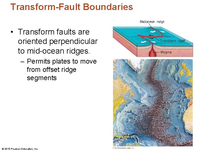
Transform-Fault Boundaries • Plates slide past one another and no new lithosphere is created or destroyed. • Most transform faults join two segments of a mid-ocean ridge. © 2013 Pearson Education, Inc.

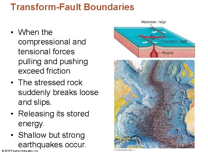
Transform-Fault Boundaries • Transform faults are oriented perpendicular to mid-ocean ridges. – Permits plates to move from offset ridge segments © 2013 Pearson Education, Inc.

Transform-Fault Boundaries • The plates slide past each other very slowly. • In some locations the friction is so great that entire sections of rock become “stuck. ” © 2013 Pearson Education, Inc.

Transform-Fault Boundaries • When the compressional and tensional forces pulling and pushing exceed friction • The stressed rock suddenly breaks loose and slips. • Releasing its stored energy. • Shallow but strong earthquakes occur. © 2013 Pearson Education, Inc.

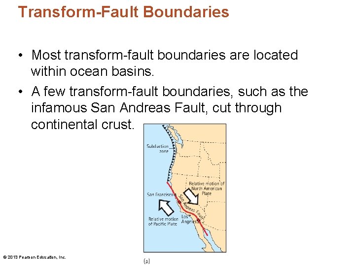
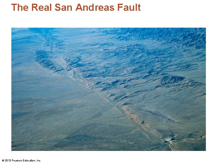
Transform-Fault Boundaries • Most transform-fault boundaries are located within ocean basins. • A few transform-fault boundaries, such as the infamous San Andreas Fault, cut through continental crust. © 2013 Pearson Education, Inc.

• The San Andreas Fault is the thickest fault between the North American Plate and the Pacific Plate in California. • The slice of CA to the west of the fault is slowly moving NW, while the rest of CA is moving SE. © 2013 Pearson Education, Inc.

• LA will not split off and fall into the ocean! – It is actually slowly! Moving NW towards San Francisco – And San Francisco is slowly moving SE. – In ~ 16 million years the two cities should be side by side. • In the meantime, CA residents can expect plenty of earthquakes. © 2013 Pearson Education, Inc.

The Real San Andreas Fault © 2013 Pearson Education, Inc.

Life in the Trenches • The Mariana Trench is the deepest trench. – 11, 000 m (7 miles) below sea level. – If you sank Mt. Everest to the bottom of the trench there would still be a mile of ocean above it. • Conditions are extreme. – Water is nearly frozen. – Pressure reaches more than 1000 atm (~16, 000 lb per square inch) – Sunlight is totally absent. © 2013 Pearson Education, Inc.

Life in the Trenches • Yet life thrives in the trenches. • Extremophiles are organisms adapted to the extreme conditions found at great depth in ocean trenches. – Species include worms, shrimp, fish, crabs, and microbes. – We don’t understand how these animals can survive in this type of environment. © 2013 Pearson Education, Inc.

Life in the Trenches • Some ocean trenches contain hydrothermal vents, which are cracks in the crust often associated with tectonic activity. • Heat and chemicals such as hydrogen sulfide are released. • Pressure-adapted bacteria consume these materials and convert the chemicals into energy they need for life. – They produce oxygen as a waste product through a process called chemosynthesis. © 2013 Pearson Education, Inc.

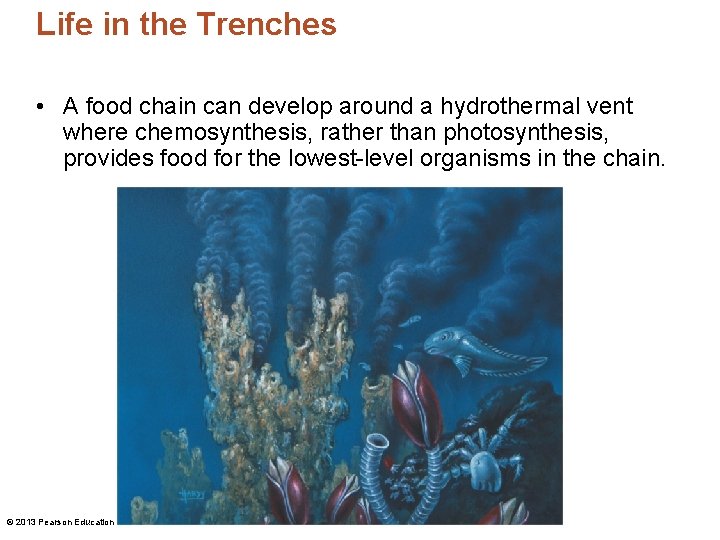
Life in the Trenches • A food chain can develop around a hydrothermal vent where chemosynthesis, rather than photosynthesis, provides food for the lowest-level organisms in the chain. © 2013 Pearson Education, Inc.