Waters Thermal Properties Water is solid liquid and


 Walker Cell Circulation disrupted • High pressure")


 refers to a part of")


- Slides: 38
Water’s Thermal Properties • Water is solid, liquid, and gas at Earth’s surface. • Water influences Earth’s heat budget. Water’s Three States of Matter
Latent Heat of Vaporization = 600 calories / 1 g Latent Heat of Condensation = 600 calories / 1 g Latent Heat of Fusion= 80 calories / 1 g How much energy to sublimate? http: //www 2. chemistry. msu. edu/courses/cem 152/snl_cem 152_SS 12/pracprob/practiceexam 1. html
Surface Salinity Variation by Latitude
Temperature and Density Variation With Depth • Pycnocline – abrupt change of density with depth • Thermocline – abrupt change of temperature with depth
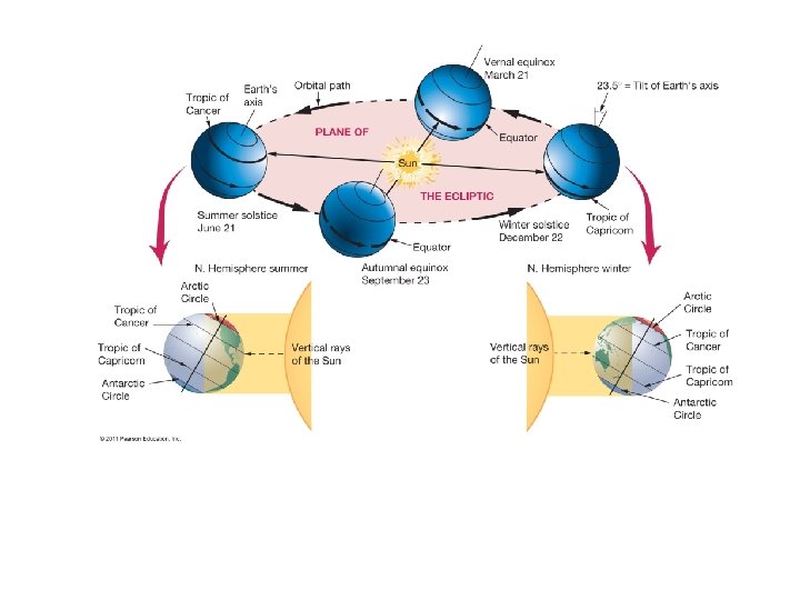
CHAPTER 6 Air-Sea Interaction • The atmosphere and the ocean are coupled in many ways. • Earth has seasons because of the tilt on its axis. • There are three major wind belts in each hemisphere. • The Coriolis effect influences atmosphere and ocean behavior. • Oceanic climate patterns are related to solar energy distribution.
Heat Gained and Lost © 2011 Pearson Education, Inc.
Density Variations in the Atmosphere • Convection cell – rising and sinking air • Warm air rises – Less dense • Cool air sinks – More dense • Moist air rises – Less dense • Dry air sinks – More dense © 2011 Pearson Education, Inc.
Movement of the Atmosphere • Air always flows from high to low pressure. • Wind – moving air © 2011 Pearson Education, Inc.
Coriolis Force varies with latitude:
Movements in the Air • Example: a nonrotating Earth • Air rises at equator (low pressure) • Air sinks at poles (high pressure) • Air flows from high to low pressure • One convection cell or circulation cell © 2011 Pearson Education, Inc.
Global Atmospheric Circulation • Circulation Cells – one in each hemisphere – Hadley Cell: 0– 30 degrees latitude – Ferrel Cell: 30– 60 degrees latitude – Polar Cell: 60– 90 degrees latitude © 2011 Pearson Education, Inc.
Global Atmospheric Circulation • High pressure zones – descending air – Subtropical highs – 30 degrees latitude – Polar highs – 90 degrees latitude – Clear skies • Low pressure zones – rising air – Equatorial low – equator – Subpolar lows – 60 degrees latitude – Overcast skies with lots of precipitation © 2011 Pearson Education, Inc.
• Circulation Cells – one in each hemisphere – Polar Cell: 60– 90 degrees latitude – Ferrel Cell: 30– 60 degrees latitude – Hadley Cell: 0– 30 degrees latitude
Winds • Cyclonic flow – Counterclockwise around a low in Northern Hemisphere – Clockwise around a low in Southern Hemisphere • Anticyclonic flow – Clockwise around a low in Northern Hemisphere – Counterclockwise around a low in Southern Hemisphere © 2011 Pearson Education, Inc.
Winds and related forces around areas of low and high pressure above the friction level in the Northern Hemisphere. Notice that the pressure gradient force (PGF) is in red, while the Coriolis force (CF) is in blue.
Fronts • Fronts – boundaries between air masses – Warm front – Cold front • Storms typically develop at fronts. • Jet Stream – may cause unusual weather by steering air masses. © 2011 Pearson Education, Inc.
CHAPTER 7 Ocean Circulation
Ekman Spiral • Surface currents move at an angle to the wind. • The Ekman spiral describes speed and direction of seawater flow at different depths. • Each successive layer moves increasingly to the right in the Northern Hemisphere – Coriolis effect © 2011 Pearson Education, Inc.
Ekman Transport • Average movement of seawater under influence of wind • 90 degrees to right of wind in Northern hemisphere • 90 degrees to left of wind in Southern hemisphere © 2011 Pearson Education, Inc.
Geostrophic Flow • Ekman transport piles up water within subtropical gyres. • Surface water flows downhill and to the right. • Geostrophic flow – balance of Coriolis Effect and gravitational forces • Ideal geostrophic flow • Friction generates actual geostrophic flow © 2011 Pearson Education, Inc.
Coastal Upwelling • Ekman transport moves surface seawater offshore. • Cool, nutrient-rich deep water comes up to replace displaced surface waters. • Example: U. S. West Coast © 2011 Pearson Education, Inc.
Coastal Downwelling • Ekman transport moves surface seawater toward shore. • Water piles up, moves downward in water column • Lack of marine life © 2011 Pearson Education, Inc.
Atmospheric-Ocean Connections in the Pacific Ocean • Walker Circulation Cell – normal conditions – Air pressure across equatorial Pacific is higher in eastern Pacific – Strong southeast trade winds – Pacific warm pool on western side of ocean – Thermocline deeper on western side – Upwelling off the coast of Peru © 2011 Pearson Education, Inc.
Normal Conditions, Walker Circulation © 2011 Pearson Education, Inc.
El Nin o – Southern Oscillation (ENSO) Walker Cell Circulation disrupted • High pressure in eastern Pacific weakens • Weaker trade winds • Warm pool migrates eastward • Thermocline deeper in eastern Pacific • Downwelling • Lower biological productivity – Peruvian fishing suffers © 2011 Pearson Education, Inc.
ENSO Conditions in the Pacific Ocean © 2011 Pearson Education, Inc.
La Nin a – ENSO Cool Phase • Increased pressure difference across equatorial Pacific • Stronger trade winds • Stronger upwelling in eastern Pacific • Shallower thermocline • Cooler than normal seawater • Higher biological productivity © 2011 Pearson Education, Inc.
La Nin a Conditions © 2011 Pearson Education, Inc.
Occurrence of ENSO Events • El Niño warm phase about every 2– 10 years • Highly irregular • Phases usually last 12– 18 months • 10, 000 -year sediment record of events • ENSO may be part of Pacific Decadal Oscillation (PDO) – Long-term natural climate cycle – Lasts 20– 30 years © 2011 Pearson Education, Inc.
Thermohaline Circulation © 2011 Pearson Education, Inc.
http: //en. wikipedia. org/wiki/Thermohaline_circulation The term thermohaline circulation (THC) refers to a part of the large-scale ocean circulation that is driven by global density gradients created by surface heat and freshwater fluxes. The adjective thermohaline derives from thermo- referring to temperature and -haline referring to salt content, factors which together determine the density of sea water. Wind-driven surface currents (such as the Gulf Stream) travel polewards from the equatorial Atlantic Ocean, cooling enroute, and eventually sinking at high latitudes (forming North Atlantic Deep Water). This dense water then flows into the ocean basins. While the bulk of it upwells in the Southern Ocean, the oldest waters (with a transit time of around 1600 years) upwell in the North Pacific. Extensive mixing therefore takes place between the ocean basins, reducing differences between them and making the Earth's oceans a global system. On their journey, the water masses transport both energy (in the form of heat) and matter (solids, dissolved substances and gases) around the globe. As such, the state of the circulation has a large impact on the climate of the Earth. http: //www. tsc. upc. edu/rslab/Passive%20 Remote%20 Sensing/activities/sea%20 surface%20 salinity
http: //www. nc-climate. ncsu. edu/water/water. oceancirculations