Quantitative Land Cover Classification from MODIS A case


What is Repeatability ? Given same input data and same")
![Repeatability – What if not ? Example[1] – How high is Mt. Everest ?](https://slidetodoc.com/presentation_image/f83d04c42dfa1e81f3c26210db2125b5/image-4.jpg "Repeatability – What if not ? Example[1] – How high is Mt. Everest ?")

")


Quality Assessment(QA):only detectable ( cannot be corrected) (2)Temporal:as from previous")


 - Harmonic ANalysis of time Serils, HANTS To large extent, the success")
![Preprocessing (2) - Conditional Temporal Smoothing [1] NDVI /EVI Time Serials:growing season(Day 97 -273)](https://slidetodoc.com/presentation_image/f83d04c42dfa1e81f3c26210db2125b5/image-21.jpg "Preprocessing (2) - Conditional Temporal Smoothing [1] NDVI /EVI Time Serials:growing season(Day 97 -273)")
![� [3]NIR Time Serials: – On condition of lower-NDVI – replace higher-NIR with (average](https://slidetodoc.com/presentation_image/f83d04c42dfa1e81f3c26210db2125b5/image-22.jpg "� [3]NIR Time Serials: – On condition of lower-NDVI – replace higher-NIR with (average")
: tailored means for too noisy regions – Spatial: forest of Mt Changbai –")
 > NDWI > Red > NIR > Blue • NDVI:")
From MODIS-NDVI time serials (2)From MODIS-NDWI time serials")


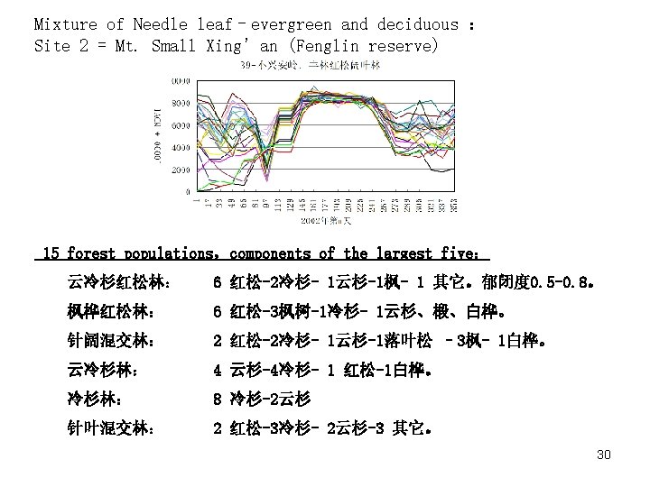
 From MODIS-NDVI, Site = Mt. Changbai Needle leaf – evergreen (left) Mixture of")


 Landcover Full Year Day 001 -353")
 Additional information From MODIS-NDWI: Irrigated vs. Non-irrigated (1) Before Day 145, all croplands")
 vs Rain-fed ( right) NDVI NDWI 36")


、Node and Decision Rules (Indices) Step 1 -2:Water and City, from 1: 100, 000")


, about 2000 Right:from MODIS")
. Repeatability should be taken into consideration during long-term environmental monitoring. (2). Quantitative")
- Slides: 45
Quantitative Land Cover Classification from MODIS - A case study in Northeast China WANG Zhengxing Global Change Information and Research Center Institute of Geographical Sciences and Natural Resources Research (NGSNRR) Chinese Academy of Sciences E-mail: wangzx@igsnrr. ac. cn 20 th CODATA Conference, Oct. , 2006,Beijing 1
OUTLINE 1、Introduction 2、Study area: NE China 3、Input data: MODIS-NDVI product 4、Output info: Land cover 5、Process: Decision Tree 6、Conclusion 2
1、Introduction: Repeatability - Quantitative (1)What is Repeatability ? Given same input data and same target classification system, the same methodology should yield same (comparable) results even used by different investigators. (2) Repeatability is essential in change detection or environmental monitoring. Yet has hardly been achieved in remote sensing application (3)Three examples 3
Repeatability – What if not ? Example[1] – How high is Mt. Everest ? In 1975: 8848. 13 meters In 2005: 8844. 43 meters Has it shrunk 3. 7 meters in last 30 years ? Not all people is so luck to know all the stories behind these DATA ! 4
Example 2 - vertical gradient zoning for vegetation in north slope of Mt. Changbai , NE China (from: Xu Wenduo) 5
Example 3. land use map of China, 1: 100, 000 (left:sparse forest, Right:dense grass) Same classification system, Different investigators, Sharp change across working border. Across Border between Inner-Mongolia and Hei-long-jiang 6
MODIS: smooth across borders between provinces 7
maximize Repeatability in land cover classification 2. Study area: NE China 3. Input Data: MODIS-NDVI product 5. Decision Tree 4. Output info: Land covers Comparable input; quantitative target information (output); transparent process 8
2、Study Area NE China: Land cover classification system Adapted from IGBP 17 -class system 9
3、INPUT DATA: MODIS VI product • • MODIS-NDVI Product: 11 layers Noise detection: 4 approaches Pre-processing: 3 approaches Data Reliability after processing 10
MODIS-NDVI Product: From NASA LP-DAAC, 1 km 16 day composites , 11 layers, • NDVI, EVI, NDVI-QA, EVI-QA, • blue, red, NIR, MIR, • 3 geometry parameters, • Derived: NDWI 11
Relationships of NDVI and original bands EVI MODIS-3, Blue 0. 459 -0. 479µm NDVI MODIS-1, red 0. 62 -0. 67µm MODIS-2, NIR 0. 841 -0. 876µm MODIS-6, MIR 1. 628 -1. 652µm NDWI 12
The quality of MODIS has been greatly improved MODIS vs AVHRR:Narrower bands avoid some noises (moisture absorption at 0. 95 um, 1. 4 um ) 13
yet still include noises 14
A case for noise detection: 7 -22, April, 2002, day 097 15
Major Sources of Noises:Cloud, fog, snow, ice • Cloud, fog: anywhere, anytime, yet more frequent in forest in rain season. The signal: – red、NIR、MIR ↑ – NDVI, EVI ↓ – normally last within 16 -32 days, except in Mt. Changbai forest • Snow, ice: spatial and temporal pattern, more occurrence in North and Higher region – Red, NIR ↑ ( > 0. 6) – NDVI, EVI ↓ ( <=0 ) – MIR↓,NDWI ↑ ( >=0. 6) 16
Noise detection: 4 means (1)Quality Assessment(QA):only detectable ( cannot be corrected) (2)Temporal:as from previous page, with water a exception (3)Spatial: • less reliable than temporal, eg,small forest/water; • Fog and snow may distributed in large region,space filters does not work well (4)Consistency of indices: Signals may be closely related • Snow = red↑ + MIR↓ • Cloud = NIR ↑+ NDVI ↓ 17
Relationships of indices for various noises: CLOUD and FOG - red↑, NIR↑, NDVI↓ (Day 97, 225, 321); SNOW and ICE - red↑, NIR↑,MIR↓, NDWI ↑ (Day 97) 18
Pre-processing: 3 approaches – Harmonic ANalysis of time Serials, HANTS – Conditional Smoothing – some specific means for too noisy regions 19
Pre-processing (1) - Harmonic ANalysis of time Serils, HANTS To large extent, the success of HANTs depends on the selection of parameters,which is quite subjective; 20
Preprocessing (2) - Conditional Temporal Smoothing [1] NDVI /EVI Time Serials:growing season(Day 97 -273) Growing season: – Dormant season: smooth for natural,expected change for cropland – With noise: replace corrupt pixel with (average of) neighbor pixels; – For continuous noises: iterative operations Dormant season:still exist some problems – For mixed noise from snow and fog: Max (NDVI)。 – An exception:water [2] Red Time Serials: Dormant season: soil, snow, evergreen Growing season: smooth for all peak noises 21
� [3]NIR Time Serials: – On condition of lower-NDVI – replace higher-NIR with (average of) neighbors � [4]MIR Time Serials: – Dormant season: “凹” = noise – Growing season: “凸” = noise – Transitional period(Day 097 -113): independent operation – Only for growing season in this study � [5]NDWI Time Serials: – Before smooth, NDWI time serials are smoother than NDVI; � 22
Pre-processing(3): tailored means for too noisy regions – Spatial: forest of Mt Changbai – Temporal: growing season (rainy season ) – Operation: subset spatially and temporally, for HANTs or manual operation 23
Reliability After Pre-processing:NDVI (EVI) > NDWI > Red > NIR > Blue • NDVI: most informative for vegetation, reliable • NDWI: from MIR and NIR. • Two advantages of MIR:less sensitive to moisture in atmosphere • Sensitive to land surface moisture。 • NDWI, like NDVI, more comparable than MIR. • Blue, red, NIR: consistent with NDVI, but less reliable than NDVI 24
4、Quantitative Description of Land Cover Types (1)From MODIS-NDVI time serials (2)From MODIS-NDWI time serials (3)Other data, (4)Used as decision rules 25
Auxiliary: Natural reserves Landuse Map, 1: 100000 IGSNRR, CAS 自然保护区 26
Field sample:Mt. Changbai, National Forest Reserve 27
(1) From MODIS-NDVI, Site = Mt. Changbai Needle leaf – evergreen (left) Mixture of evergreen and deciduous(right) Needle ever-green forest: (average) • Full year: NDVI > 0. 75 • Growing season: NDVI > 0. 80 • Dormancy: NDVI > 0. 60 28
Needle leaf -Evergreen :Mt. Changbai, evergreen/all = 28/30 29
Mixed forest: evergreen and deciduous • In study area, there is a continuous distribution of various forest. How to classifying them is a matter of definition. There is the place where subjectivity occurs. • At 740 m, the fraction of evergreen trees in mixed forest is 40%,this has been correctly described by NDVI time serials. During growing season, NDVI could be about 0. 85; during dormancy,NDVI=0. 4 -0. 5. Given the fact of baseline during dormancy (NDVI=0. 25),NDVIwinter = 0. 4 -0. 5 is a good indicator of fraction of evergreen in winter. • At 1800 m, the fraction of evergreen in the purest forest is as high as 90%,and its NDVI time serial has a high level of 0. 60 -0. 85 in whole year. 31
Problem of NDVI : Body City;Sand;Water 32
NDVI wrap-up 33
Average NDVI of Major Land Covers (10000*NDVI) Landcover Full Year Day 001 -353 Growing Season Dormancy Season Green-up Season Day 113 -273 Day 001 -097, 289 -353 Day 113 -145 Needle leaf. Evergreen 6929 7716 Needle leaf. Deciduous 4600 6704 2671 5756 Broad leaf. Deciduous 5354 7717 3187 7353 Nixed forest 5965 7615 6208 7088 4453 6918 Bush and sparse forest 3836 5422 2383 3924 Meadow grassland (South) 4531 6478 2747 4827 Meadow grassland (North) 3326 5423 1404 4066 Typical grassland 2597 4494 858 2587 Sparse grassland 2291 2909 1725 1913 Bare land / sand 1586 1825 1367 1657 Rain-fed cropland 3331 4864 1926 2557 Irrigated cropland 3413 5504 1496 2280 City and town 1955 2623 1343 2200 Water body -807 -1117 -524 -1032 34
(2) Additional information From MODIS-NDWI: Irrigated vs. Non-irrigated (1) Before Day 145, all croplands have the similar signature as soil, NDVI < 0. 25 -0. 3;during Day 145 -209, NDVI can be 0. 7 -0. 99; (2) The NDVI difference between Irrigated and non-irrigated crop land exists, but not reliable for classification (3) The signature from WATER can be best described with NDWI. 35
Irrigated (left) vs Rain-fed ( right) NDVI NDWI 36
Most sensitive period of NDWI: Day 129 -161 More information from other indices, DEM 37 …
5. Decision Tree 38
(2)、Node and Decision Rules (Indices) Step 1 -2:Water and City, from 1: 100, 000 landuse map, IGSNRR, CAS. Step 3 -5:growing season (day 113 -273 ) If NDVI day 113 -273 < 0. 30 then ‘bare soil’ If NDVI day 113 -273 = 0. 30 -0. 35 then ‘Sparce grass’ If NDVI day 113 -273 = 0. 35 -0. 45 then ‘Typical grass’ Step 6:If NDVIday 145 Step 7:If NDWIday 129 -145 sum ≤ 0. 4 then ‘crop land’ > 0. 05 and DEM<500 then ‘irrigated’ Step 8: If NDVIday 113 -273>0. 65 then ‘forest’ Step 9: If NDVIdormancy >0. 53 then ‘forest-evergreen’ Step 10: If NDVIdormancy > =0. 38 -0. 53 then ‘forest-mixed’ else ‘forest-deciduous’ Step 11:If NDWIday 97 -129<0 then ‘forest-deciduous – larix and birch ’ Step 12:If DEM<200 then ‘meadow grass’ else ‘bush’ 39
Step 1 – Water Step 2 - City 40
Step 3: Bare Soil Step 4: Sparse Grass 41
Step 10: Mixed Forest 42
Step 13: Bush and Meadow 43
Validation of Step 8 Left:manually interpretated from TM (1: 100000), about 2000 Right:from MODIS 1 Km NDVI-NDWI, in 2002 44
6、Conclution (1). Repeatability should be taken into consideration during long-term environmental monitoring. (2). Quantitative description of land cover types could reduce subjectivity; especially in transitional regions. (3). Input data quality should be carefully examined and processed. (4). Both MODIS-NDVI and MODIS-NDWI are useful for quantitative description of land covers, other indices may have further information. (5). More data and knowledge are needed to enhance the seperability of some land cover types: less productive cropland / grass… 45