LANCE MODIS and VIIRS NASA LANCE UWG Workshop

- Slides: 20
LANCE MODIS and VIIRS NASA LANCE UWG Workshop April 17, 2019 Robert Wolfe, NASA GSFC, Code 619
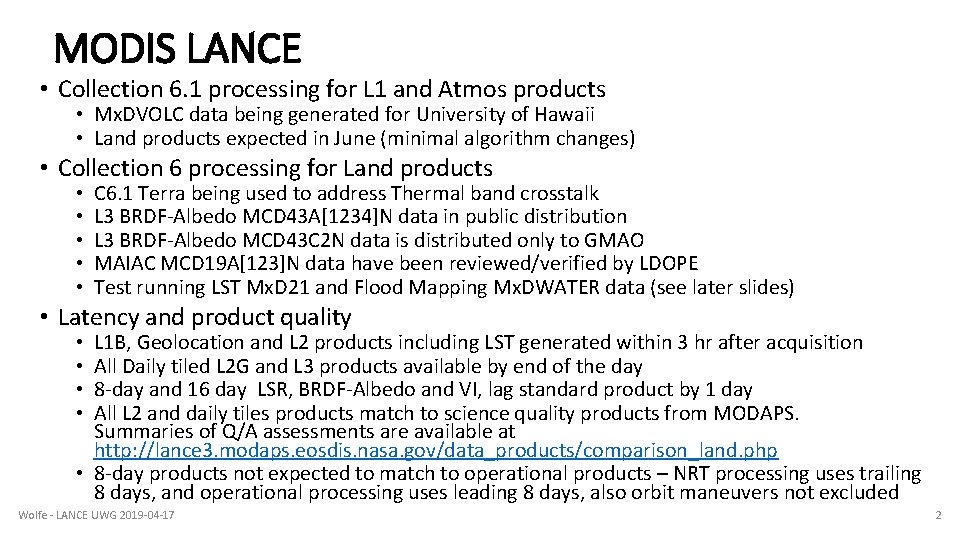
MODIS LANCE • Collection 6. 1 processing for L 1 and Atmos products • Mx. DVOLC data being generated for University of Hawaii • Land products expected in June (minimal algorithm changes) • Collection 6 processing for Land products • • • C 6. 1 Terra being used to address Thermal band crosstalk L 3 BRDF-Albedo MCD 43 A[1234]N data in public distribution L 3 BRDF-Albedo MCD 43 C 2 N data is distributed only to GMAO MAIAC MCD 19 A[123]N data have been reviewed/verified by LDOPE Test running LST Mx. D 21 and Flood Mapping Mx. DWATER data (see later slides) • Latency and product quality L 1 B, Geolocation and L 2 products including LST generated within 3 hr after acquisition All Daily tiled L 2 G and L 3 products available by end of the day 8 -day and 16 day LSR, BRDF-Albedo and VI, lag standard product by 1 day All L 2 and daily tiles products match to science quality products from MODAPS. Summaries of Q/A assessments are available at http: //lance 3. modaps. eosdis. nasa. gov/data_products/comparison_land. php • 8 -day products not expected to match to operational products – NRT processing uses trailing 8 days, and operational processing uses leading 8 days, also orbit maneuvers not excluded • • Wolfe - LANCE UWG 2019 -04 -17 2
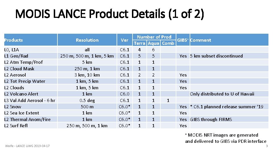
MODIS LANCE Product Details (1 of 2) Products L 0, L 1 A L 1 Geo/Rad L 2 Atm Temp/Prof L 2 Cloud Mask L 2 Aerosol L 2 Tot Precip Water L 2 Clouds L 2 Volcano Alert L 3 Val Add Aerosol - 6 hr L 2 Snow L 2 Sea Ice Extent L 2 Thermal Anom/Fire L 2 Surf Refl Resolution Ver all 250 m, 500 m, 1 km, 5 km 250 m, 1 km 3 km, 10 km 1 km, 5 km 1 km 0. 5 deg 500 m 1 km 250 m, 500 m, 1 km C 6. 1 C 6. 0* Number of Prod Terra Aqua Comb 4 6 5 5 1 1 2 2 1 1 1 1 1 GIBS+ Comment Yes 5 km subset discontinued Yes Yes Only distributed to U of Hawaii Yes * C 6. 1 planned release summer ‘ 19 Yes GIBS through FIRMS Yes MODIS NRT images are generated and delivered to GIBS via PDR interface + Wolfe - LANCE UWG 2019 -04 -17 3
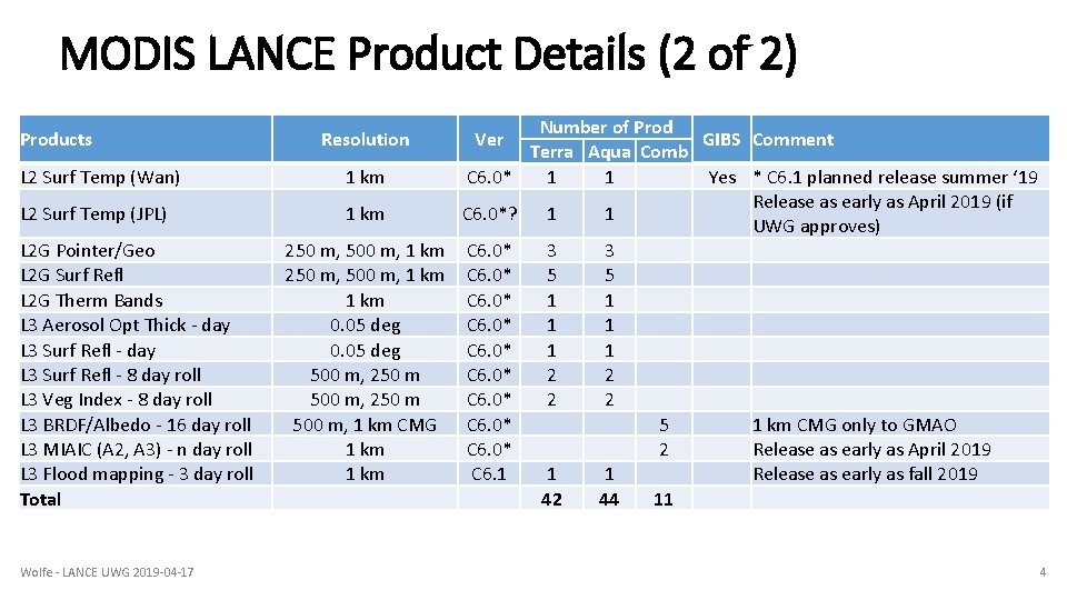
MODIS LANCE Product Details (2 of 2) Products L 2 Surf Temp (Wan) L 2 Surf Temp (JPL) L 2 G Pointer/Geo L 2 G Surf Refl L 2 G Therm Bands L 3 Aerosol Opt Thick - day L 3 Surf Refl - 8 day roll L 3 Veg Index - 8 day roll L 3 BRDF/Albedo - 16 day roll L 3 MIAIC (A 2, A 3) - n day roll L 3 Flood mapping - 3 day roll Total Wolfe - LANCE UWG 2019 -04 -17 Number of Prod GIBS Comment Terra Aqua Comb 1 km C 6. 0* 1 1 Yes * C 6. 1 planned release summer ‘ 19 Release as early as April 2019 (if 1 km C 6. 0*? 1 1 UWG approves) 250 m, 500 m, 1 km C 6. 0* 3 3 250 m, 500 m, 1 km C 6. 0* 5 5 1 km C 6. 0* 1 1 0. 05 deg C 6. 0* 1 1 500 m, 250 m C 6. 0* 2 2 500 m, 1 km CMG C 6. 0* 5 1 km CMG only to GMAO 1 km C 6. 0* 2 Release as early as April 2019 1 km C 6. 1 1 1 Release as early as fall 2019 42 44 11 Resolution Ver 4
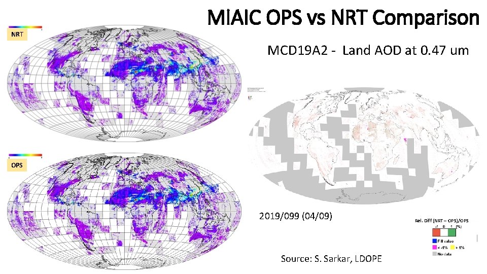
NRT MIAIC OPS vs NRT Comparison MCD 19 A 2 - Land AOD at 0. 47 um OPS 2019/099 (04/09) Source: S. Sarkar, LDOPE Rel. Diff (NRT – OPS)/OPS
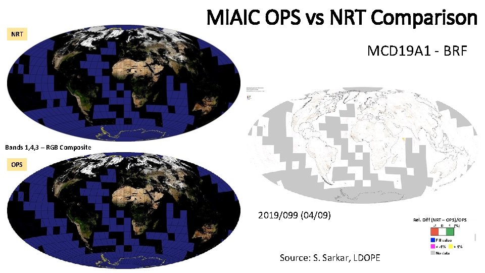
NRT MIAIC OPS vs NRT Comparison MCD 19 A 1 - BRF Bands 1, 4, 3 – RGB Composite OPS 2019/099 (04/09) Source: S. Sarkar, LDOPE Rel. Diff (NRT – OPS)/OPS
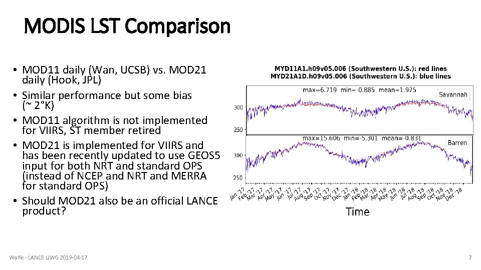
MODIS LST Comparison • MOD 11 daily (Wan, UCSB) vs. MOD 21 daily (Hook, JPL) • Similar performance but some bias (~ 2°K) • MOD 11 algorithm is not implemented for VIIRS, ST member retired • MOD 21 is implemented for VIIRS and has been recently updated to use GEOS 5 input for both NRT and standard OPS (instead of NCEP and NRT and MERRA for standard OPS) • Should MOD 21 also be an official LANCE product? Wolfe - LANCE UWG 2019 -04 -17 7
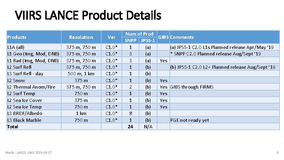
VIIRS LANCE • NRT running standard VIIRS Collection 1 PGEs for Suomi NPP • Latency is 3 hr for L 1/2 products • All products are of same science quality as the standard science V 1 products produced by the Land SIPS and distributed by the DAACs • Products placed into near real time processing after the standard science products are available at the DAACs and near real time version has been reviewed and approved by the PI • BRDF is test running and being evaluated by LDOPE • JPSS 1 (NOAA-20) L 1 V 2 products are in standard forward processing and in test for NRT (waiting on improved geo/cal LUTs) • Note these are in the new NASA HDF 5 format • V 2 products for L 1 SNPP and L 2+ SNPP and JPSS-1 will be available in Aug/Sept Wolfe - LANCE UWG 2019 -04 -17 8
VIIRS LANCE Product Details Products L 1 A (all) L 1 Geo (Img, Mod, DNB) L 1 Rad (Img, Mod, DNB) L 2 Surf Refl L 3 Surf Refl - day L 2 Snow L 2 Thermal Anom/Fire L 2 Surf Temp L 2 Sea Ice Cover L 2 Sea Ice Temp L 3 BRDF/Albedo L 3 Black Marble Total Wolfe - LANCE UWG 2019 -04 -17 Resolution Ver 375 m, 750 m 500 m, 1 km 375 m, 750 m 375 m 750 m 1 km 750 m C 1. 0* C 1. 0* Num of Prod SNPP JPSS-1 1 (a) 3 (a) 1 (b) 2 (b) 1 (b) 8 (b) 1 (b) 24 N/A GIBS Comments (a) JPSS-1 C 2. 0 L 1 s Planned release Apr/May ’ 19 * SNPP C 2. 0 Planned release Aug/Sept ’ 19 Yes (b) JPSS-1 C 2. 0 L 2+ Planned release Aug/Sept ’ 19 Yes GIBS through FIRMS Yes Yes PGE not ready yet 9
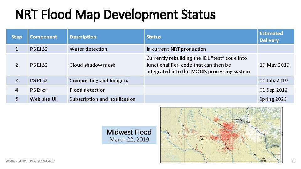
NRT Flood Map Development Status Step 1 Component Description Status PGE 152 Water detection In current NRT production Currently rebuilding the IDL “test” code into functional Perl code that can then be integrated into the MODIS processing system Estimated Delivery 2 PGE 152 Cloud shadow mask 10 May 2019 3 PGE 152 Compositing and Imagery 01 July 2019 4 PGExxx Flood detection 01 Sep 2019 5 Web site UI Subscription and notification Spring 2020 Midwest Flood March 22, 2019 Wolfe - LANCE UWG 2019 -04 -17 10
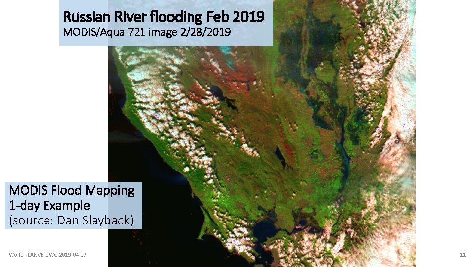
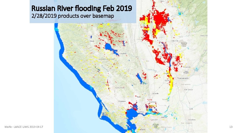
Russian River flooding Feb 2019 MODIS/Aqua 721 image 2/28/2019 MODIS Flood Mapping 1 -day Example (source: Dan Slayback) Wolfe - LANCE UWG 2019 -04 -17 11
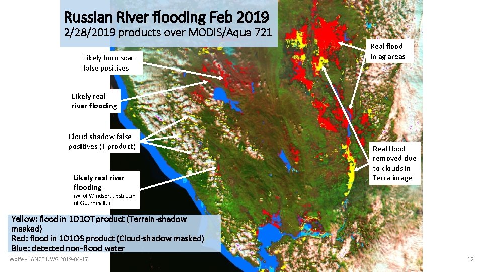
Russian River flooding Feb 2019 2/28/2019 products over MODIS/Aqua 721 Likely burn scar false positives Real flood in ag areas Likely real river flooding Cloud shadow false positives (T product) Likely real river flooding Real flood removed due to clouds in Terra image (W of Windsor, upstream of Guerneville) Yellow: flood in 1 D 1 OT product (Terrain-shadow masked) Red: flood in 1 D 1 OS product (Cloud-shadow masked) Blue: detected non-flood water Wolfe - LANCE UWG 2019 -04 -17 12
Russian River flooding Feb 2019 2/28/2019 products over basemap Wolfe - LANCE UWG 2019 -04 -17 13
Cloud Shadows and Flood Products • Each MODIS image has a Water product calculated by looking for dark/black pixels, which are categorized as water. • To create a Flood product, the Water product is compared to previous Water products for the grid tile. The differences are ascribed to flood waters. • The problem with this is that Cloud Shadows often appear the same as water (dark/black pixels). This can make the Water product inaccurate. • Thus, a Cloud Shadow product (see next slide) is needed to map the shadowed pixels so that they can be removed from the Water product. • A Flood product can then be calculated without being contaminated by Cloud Shadows. Wolfe - LANCE UWG 2019 -04 -17 14
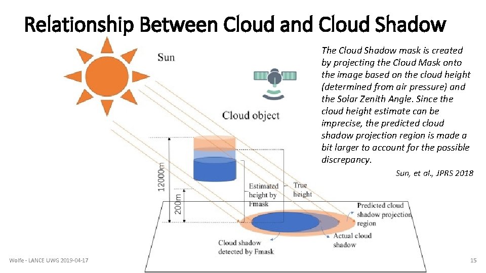
Relationship Between Cloud and Cloud Shadow The Cloud Shadow mask is created by projecting the Cloud Mask onto the image based on the cloud height (determined from air pressure) and the Solar Zenith Angle. Since the cloud height estimate can be imprecise, the predicted cloud shadow projection region is made a bit larger to account for the possible discrepancy. Sun, et al. , JPRS 2018 Wolfe - LANCE UWG 2019 -04 -17 15
Calculating Cloud Shadows Computing Cloud shadows: 1. For each MODIS image, a Cloud Mask is created, based on bright pixels 2. Each MODIS image has an Cloud Top Air Pressure product. This is used to compute the height of the clouds 3. Based on the Solar Zenith Angle and the cloud height, the Cloud Mask is mapped onto the ground and the ground pixels masked as shadows, to create a Cloud Shadow Mask Wolfe - LANCE UWG 2019 -04 -17 16
Backup slides Wolfe - LANCE UWG 2019 -04 -17 17
Current Flood Map Examples Flooding in Mozambique, 2019 https: //floodmap. modaps. eosdis. nasa. gov/get. Tile. php? location=030 E 010 S& day=85&year=2019&product=2 Flooding in Nebraska/Iowa/mid-west, 2019: https: //floodmap. modaps. eosdis. nasa. gov/get. Tile. php? location=100 W 050 N &day=81&year=2019&product=3 https: //floodmap. modaps. eosdis. nasa. gov/get. Tile. php? location=100 W 040 N &day=081&year=2019&product=3 Wolfe - LANCE UWG 2019 -04 -17 18
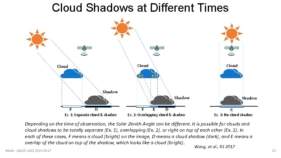
Cloud Shadows at Different Times Ex. 1: Separate cloud & shadow Ex. 2: Overlapping cloud & shadow Ex. 3: No cloud shadow Depending on the time of observation, the Solar Zenith Angle can be different. It is possible for clouds and cloud shadows to be totally separate (Ex. 1), overlapping (Ex. 2), or right on top of each other (Ex. 3). In each of these cases, F means a cloud (bright) on the image, D means a cloud shadow (dark), and E means a overlap of the cloud on top of the shadow, which looks like a cloud (bright). Wolfe - LANCE UWG 2019 -04 -17 Wang, et al. , RS 2017 19
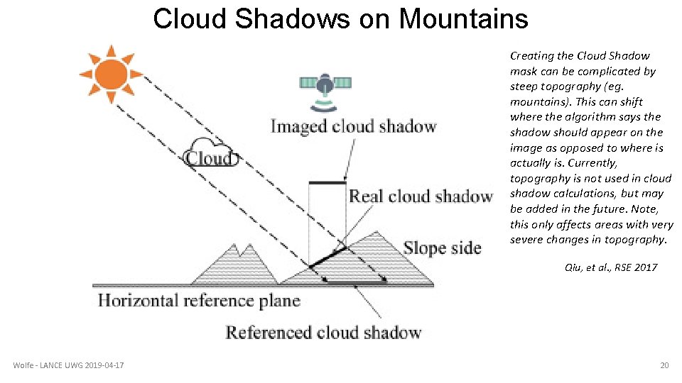
Cloud Shadows on Mountains Creating the Cloud Shadow mask can be complicated by steep topography (eg. mountains). This can shift where the algorithm says the shadow should appear on the image as opposed to where is actually is. Currently, topography is not used in cloud shadow calculations, but may be added in the future. Note, this only affects areas with very severe changes in topography. Qiu, et al. , RSE 2017 Wolfe - LANCE UWG 2019 -04 -17 20