Weather Forecasting How Air Moves Recall the solar


 air masses are cold")


- Slides: 36
Weather Forecasting
How Air Moves • Recall the solar variation on the Earth……. • What location on the Earth receives the most direct sunlight? • What causes wind (air) to blow? • Air moves (H) High pressure (L) Low pressure
Formation of Air Masses air mass a large body of air with similar temperature and moisture content throughout • When air pressure differences are small, air remains relatively stationary. • Air masses that form over frozen polar regions are very cold and dry. • Air masses that form over tropical oceans are warm and moist.
Continental and Maritime Air Masses • Continental polar (c. P) air masses are cold and dry. • Continental tropical (c. T) air masses are warm and dry. • Maritime polar (m. P) air masses are moist and cold. • Maritime tropical (m. T) air masses are moist and warm. ? What do you think happens when moist maritime air masses travel to new locations? • 6 different air masses affect N. America
In summer, polar air masses usually bring cool, dry weather. In winter, very cold and wet weather to the northern United States. Moist: summer rain, winter snow dry, hot weather to deserts in the summer Warm, moist air
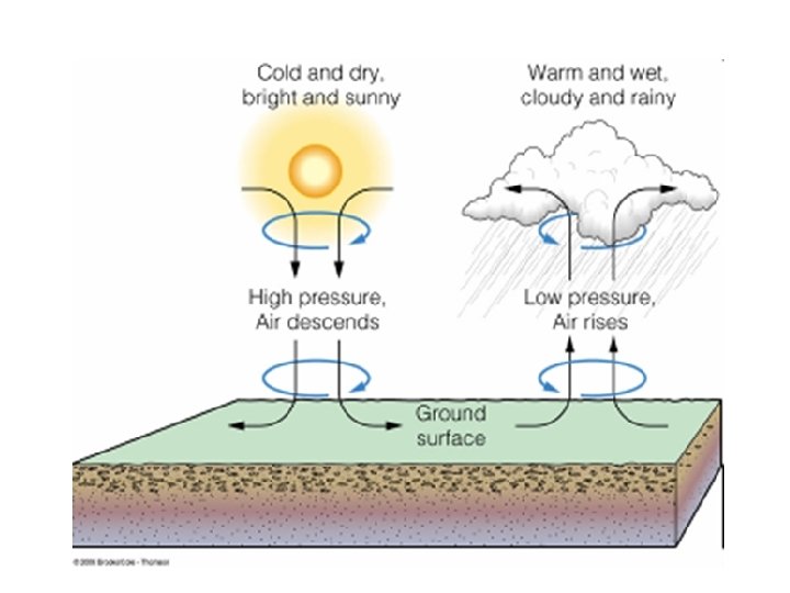
H: HIGH PRESSURE SYSTEM • A high pressure system is an area that has diverging winds (spreading out) on the surface. • Anticyclone: clockwise in Northern Hemisphere • fair or dry weather, because sinking air does not promote cloud formation.
L: Low Pressure System • A low pressure system is an area that has converging winds on the surface. • Cyclones: counterclockwise in Northern Hemisphere • Stormy weather is often associated with low pressure systems
Hurricane Katrina, August 28, 2005
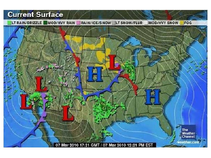
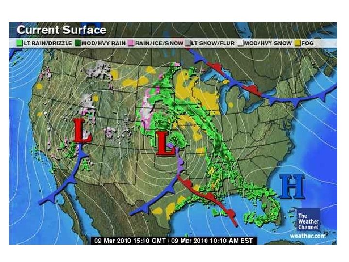
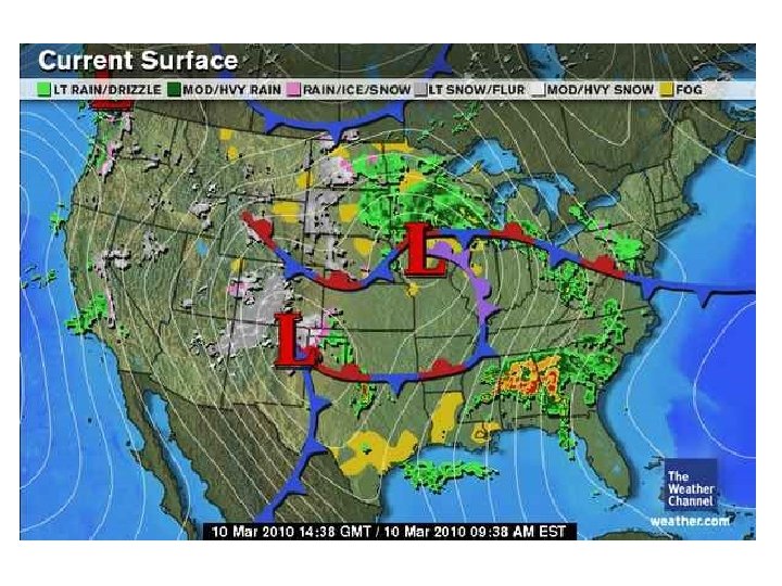
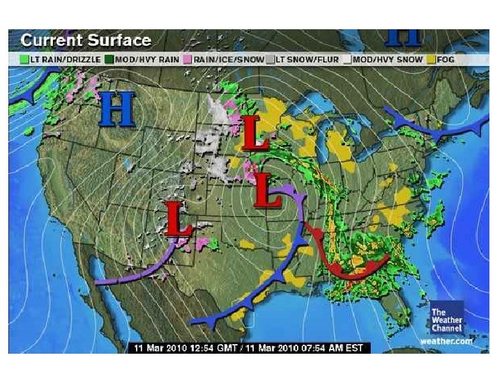
Weather Maps • Atmospheric Pressure: the amount of atmospheric mass above a specific location • Isobars: line drawn on a weather map connecting points of equal pressure • Wind barbs: shows the wind direction and speed
Fronts animation • Play fronts
FRONTS • A cool air mass is more dense than warm air mass. • Front: the boundary that forms between air masses of different densities. • Changes in weather take place along the various types of fronts. • Many fronts occur in the mid-latitudes due to variation in temperature. • Why don’t we see fronts in the tropics?
COLD FRONT cold front: cold air mass displaces warm air mass, forces warm air up (wedge) • If the warm air is moist, clouds, showers, and thunderstorms. Direction of flow
Cold front animation • Play cold front
Warm Fronts warm front: warm air displaces cold air • A warm front produces very cloudy with precipitation over a large area and may cause violent weather. w f flo no ctio Dire
Warm front animation • Play warm front
Stationary and Occluded Fronts stationary front: a front between warm and cold air masses that is moving very slowly or not at all. Somewhat cloudy, light precipitation occluded front: a front that forms when a cold air mass overtakes a warm air mass and lifts the warm air mass off the ground and over another air mass Stormy weather (cyclone) produced
Play: Reading a Weather Map
Weather vs Climate • Weather is a short term, atmospheric phenomena interaction. Measured in minutes, hours, days, weeks or months. • Climate is how the atmosphere behaves and changes over a long period of time. (30 years or more)
Why is it warmest during the middle of the day and cooler in the morning and evening? • The Sun’s rays hit the surface more directly in the middle of the day as it is overhead. The same amount of energy is released during the morning and evening hours, but the Sun’s rays are hitting the surface at an angle and the energy is spread out over a larger area.
Relative Humidity • When people say "It's not the heat--it's the humidity!" they're really referring to the relative humidity, or the amount of water in the air at a certain temperature compared to how much water the air can hold at that temperature.
Relative Humidity • Air, like all gases, expands at higher temperatures. So air can hold more water vapor at higher temperatures than it can at lower temperatures. The amount of humidity in the air affects how quickly water can evaporate from surfaces such as roads, lakes, even your skin!
Relative Humidity • For example, at an air temperature of 80 degrees, 60 percent humidity might be very comfortable. But at 90 percent humidity, sweat evaporates from your skin very slowly, and you feel hot and sticky.
Local Weather Report 1. What is the current weather like in Athens, Georgia? 2. Why are those conditions present? 3. What is the projected weather for tomorrow? 4. What is the current temperature in Athens? 5. What are the wind conditions in Athens?
Coriolis Effect Lab • Before we go upstairs to do the Coriolis Effect lab here a few facts.
Why Air Moves? • Wind is created by differences in air pressure. The greater the pressure is, the faster the wind moves. The difference in air pressure is generally caused by the unequal heat of the Earth. • Air moves from high to low • Winds moves from poles to equator
Why Air Moves? • Temperature and pressure difference on Earth’s surface create three wind belts in the Northern Hemisphere and three wind belts in the Southern Hemisphere. The Coriolis effect which occurs when winds are deflected by Earth’s rotation also influences wind patterns.
What is the Coriolis Effect? • Winds don’t blow directly North or South. The movement of wind is affected by the rotation of the Earth, causing the wind to travel in a curved path rather than a straight line. The curving or moving objects, such as wind, by Earth’s rotation is called the Coriolis Effect. Because of this, the winds in the Northern Hemisphere curve to the right, and those in the Southern Hemisphere curve to the left.
What is the Coriolis Effect? • The circulation of the atmosphere and of the oceans is affected by the rotation of Earth on its axis. Earth’s rotation causes its diameter to be greatest through the equator and smallest through the poles. • Because each point on Earth makes one complete rotation every day, points near the equator travel farther and faster in a day than points closer to the poles do.
What is the Coriolis Effect? • When air moves toward the poles, it travels east faster then the land beneath it does. As a result, the air follows a curved path. The tendency of a moving object to follow a curved path rather than a straight path because of the rotation of Earth is called the Coriolis effect.
What is the Coriolis Effect? • Air moving south from the pole is deflected to the right because the air moves east slower than the ground beneath it does. • Air moving north from the equator is deflected to the right because the air is moving east faster than the ground beneath it is.
Coriolis Effect Lab • The rotation of Earth in an easterly direction causes the Coriolis effect. The Coriolis effect, in turn, influences the direction of all freemoving objects, such as air and water. The Coriolis effect greatly influences the movement of global wind patterns and ocean currents. • How does the Coriolis effect deflect the movement of air and water in each hemisphere?