Forecasting the Weather Forecasting Predicting the weather for
- Slides: 14

Forecasting the Weather Forecasting: Predicting the weather for the future based on measurements made of certain characteristics of the atmosphere. These predictions are often put in the form of probability of occurrence (percentage chance of occurring). Meteorologists are the scientists who study the atmosphere and attempt to make predictions. Modern forecasting relies on the fact that the gases in the atmosphere obey a certain set of physical characteristics. Modern forecasting also relies on satellites images, and Doppler radar.

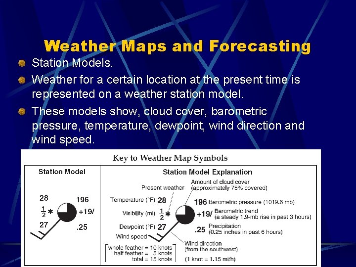
Weather Maps and Forecasting Station Models. Weather for a certain location at the present time is represented on a weather station model. These models show, cloud cover, barometric pressure, temperature, dewpoint, wind direction and wind speed.

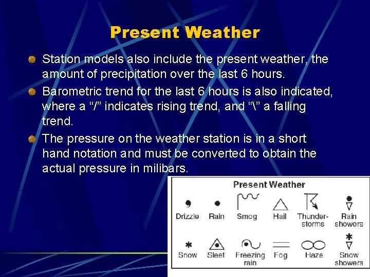
Present Weather Station models also include the present weather, the amount of precipitation over the last 6 hours. Barometric trend for the last 6 hours is also indicated, where a “/” indicates rising trend, and “” a falling trend. The pressure on the weather station is in a short hand notation and must be converted to obtain the actual pressure in milibars.

Converting from short-hand pressure to milibars of pressure on weather station models. For values on the station of 500 or MORE, a 9 must be added in front of the number, and a decimal between the last two numbers. For values on the station less then 500 a 10 must be added in front of the number, and a decimal between the last two numbers. Station Model Value: 682 Actual Milibars of Pressure: 968. 2 Station Model Value: 408 Actual Milibars of Pressure: 1040. 8

Lines on Weather Map Isobars: Lines connecting points of equal barometric pressure Isotherms: Lines connecting points of equal temperature. Pressure Gradient: If given two cities, 200 miles apart City A has a barometric pressure of 1032. 9 milibars and City B has a barometric pressure of 976. 8, what is the pressure gradient?

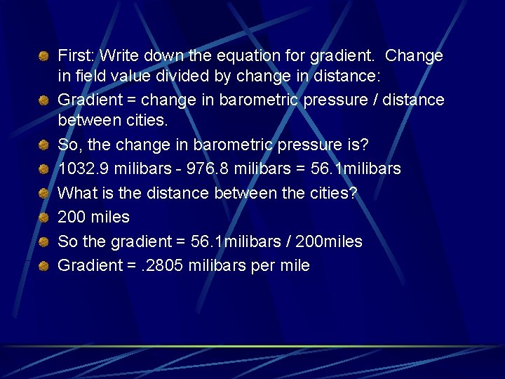
First: Write down the equation for gradient. Change in field value divided by change in distance: Gradient = change in barometric pressure / distance between cities. So, the change in barometric pressure is? 1032. 9 milibars - 976. 8 milibars = 56. 1 milibars What is the distance between the cities? 200 miles So the gradient = 56. 1 milibars / 200 miles Gradient =. 2805 milibars per mile

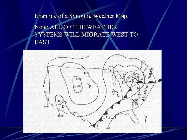
Synoptic Weather Maps Provide a synopsis or summary of all of the weather currently occurring for an area. On these maps, isobars, isotherms, fronts, high and low pressure systems, wind speed and direction, and the location of fronts are all recorded. They are recorded on these map by using weather station models for a majority of the data. Also “H”s are used to designate the center of high pressure systems. “L”s are used to designate the center of low pressure systems.

Example of a Synoptic Weather Map. Note: ALL OF THE WEATHER SYSTEMS WILL MIGRATE WEST TO EAST

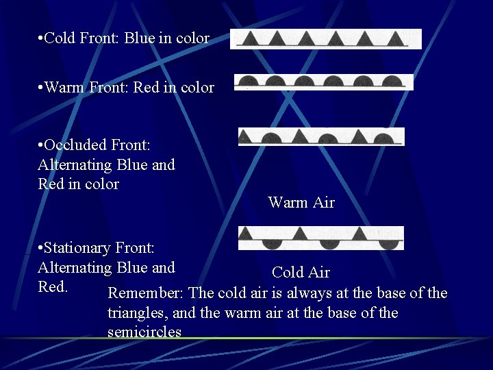
Front Symbols for Synoptic Weather Maps The following symbols represent the various weather fronts on synoptic weather maps. Some or all of the symbols may be present It is important to remember the relative positions of air masses in regards to fronts. (which air mass is moving!) When these details are all provided on a Map of the USA it is important to remember that whole systems will move FROM WEST TO EAST!!! ALWAYS!

• Cold Front: Blue in color • Warm Front: Red in color • Occluded Front: Alternating Blue and Red in color Warm Air • Stationary Front: Alternating Blue and Cold Air Red. Remember: The cold air is always at the base of the triangles, and the warm air at the base of the semicircles

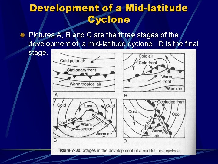
Development of a Mid-latitude Cyclone Pictures A, B and C are three stages of the development of a mid-latitude cyclone. D is the final stage.

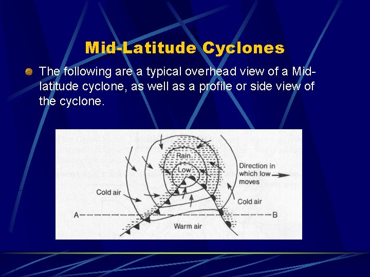
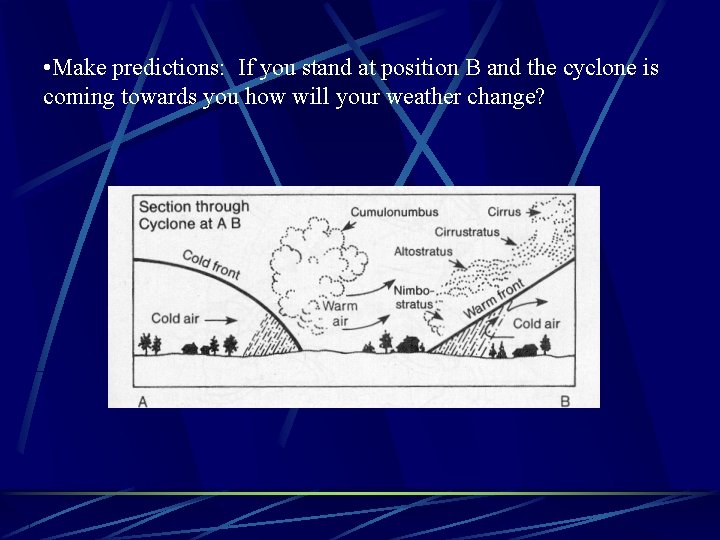
Mid-Latitude Cyclones The following are a typical overhead view of a Midlatitude cyclone, as well as a profile or side view of the cyclone.

• Make predictions: If you stand at position B and the cyclone is coming towards you how will your weather change?

Prevailing Westerlies In the USA weather systems (high/low pressure systems) generally move from west to east. For this reason the weather you see to the WEST of your location on the synoptic weather map is the weather you are most likely to see in the next few days.