Weather Forecasting Weather Forecasting Weather Forecast a prediction


 Tropical Zones 2) Temperate Zones")


- Slides: 23
Weather Forecasting
Weather Forecasting Ø Weather Forecast – a prediction of weather conditions over the next few days Ø Meteorologists use special instruments to collect data for weather forecasting
Weather Forecasting Tools Ø Weather Balloons – carries electronic equipment up to 30 km high which measures: • temperature • air pressure • relative humidity • wind speed & direction Ø Transmits radio signals to meteorologists
Weather Forecasting Tools Ø Windsock – a cone-shaped cloth bag that is open at both ends Ø wind enters wide end and exits through narrow end Ø wide end always points into the wind
Weather Forecasting Tools Ø Wind Vane – shaped like an arrow and attached to a pole Ø wind pushes the tail of arrow Ø vane spins until arrow points into wind
Weather Forecasting Tools Ø Anemometer – measures wind speed Ø has three or four cups connected to a pole with spokes Ø wind pushes on open side of cups and makes them spin Ø this spinning produces an electric current which is displayed on a dial
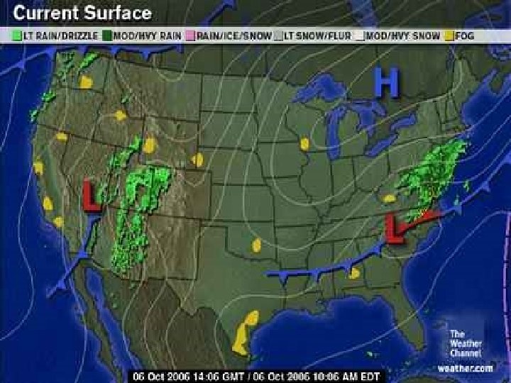
Weather Forecasting Tools Ø Radar – used to locate fronts and air masses Ø can show much precipitation is falling and what kind it is
Weather Forecasting Tools Ø Satellites – orbits Earth to produce images of weather systems Ø can also measure wind speeds, humidity, and temperatures Ø used to track storms
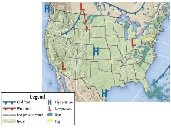
Weather Maps Ø Weather Maps: Ø contain a station model – a symbol that shows the weather at a certain location
Weather Maps Ø Weather Maps: Ø contain isobars – lines that connect points of equal air pressure Ø closed circles represent areas of high or low pressure
Weather Maps Ø Weather Maps show: Ø fronts Ø air masses Ø high pressure Ø low pressure Ø temperature Ø precipitation
Recap!!! How is an anemometer different from a windsock or a wind vane? Anemometers measure wind speed. Windsocks and wind vanes are used to find wind direction. What is a weather balloon and how does it work? It carries electronic equipment up to 30 km high and transmits radio signals to meteorologists. It measures temperature, air pressure, relative humidity, wind speed & direction.
2 3 Isobar Cold Front 1 High Pressure 4 Warm Front 5 Low Pressure What does each symbol stand for? 6 Stationary Front
Climate Zones
Climate Zones Ø There are three climate zones: 1) Tropical Zones 2) Temperate Zones 3) Polar Zones
Climate Zones Ø Tropical Zone – known as the Tropics because it receives so much solar energy, it has high temperatures – hottest climate zone Ø found between 23. 5 N and 23. 5 S latitude Ø surrounds the equator
Climate Zones Ø Temperate Zone – receives less solar energy than the Tropical Zone Ø temperatures tend to vary depending on location and time of year Ø this is the middle zone found between 23. 5 and 66. 5 north or south latitudes Ø most of the US is in this zone
Climate Zones Ø Polar Zone – is the coldest climate zone Ø found between 66. 5 and 90 north and south latitudes Ø extends to the poles
Recap!!! What are three climate zones? Tropical Zone, Temperate Zone, & Polar Zone Which zone surrounds the equator? Tropical Zone Which zone extends to the poles? Polar Zone Which zone has temperatures that vary? Temperate Zone
Recap!!! Which zone is the coldest climate zone? Polar Zone Which zone is the hottest climate zone? Tropical Zone Which climate zone is most of the US located in? Temperate Zone
1 Polar Zone 2 Temperate Zone 3 Tropical Zone 4 Tropical Zone 5 Temperate Zone 6 Polar Zone Label the climate zones