Topic 10 Weather Analysis Forecasting Predicting Severe Weather
- Slides: 37

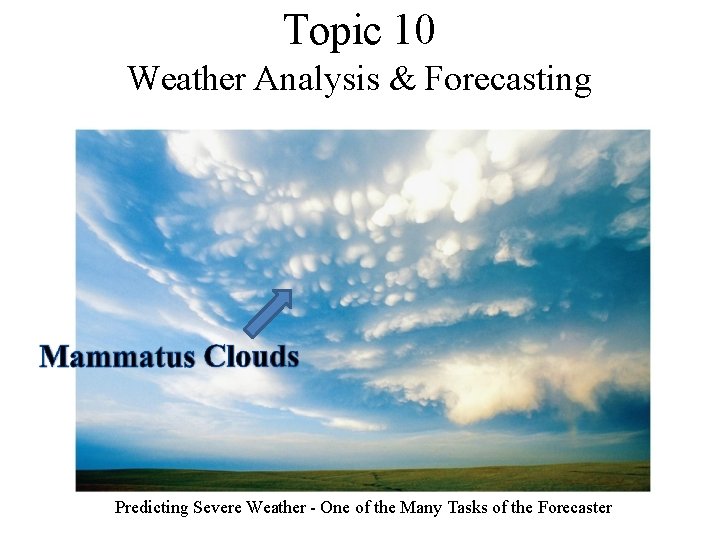
Topic 10 Weather Analysis & Forecasting Predicting Severe Weather - One of the Many Tasks of the Forecaster

U. S. Forecasting History • Many American scientists were given credit with adding contributions to premodern era meteorology from the 1750’s through the mid 1950’s. • However, Benjamin Franklin is credited with making the first long-term weather predictions in his Poor Richards Almanac beginning in 1732. He continued to study and collect weather data until his death in 1790. – However, these forecasts were based primarily on weather folklore. • On February 9, 1870, President Ulysses S. Grant signed a law directing the Secretary of War to take meteorological observations and give warnings of the approach of storms • The law created the National Weather Service, then called the United States Weather Bureau • On July 1, 1891, The United States Weather Bureau became a civilian agency and was part of the Department of Agriculture until 1940. • In 1940 President Franklin D. Roosevelt moved the Weather Bureau to the Department of Commerce since weather plays such an important role for the aviation community, and therefore commerce

• • The National Weather Service remains as part of the Department of Commerce today • During the late 1940 s, the military gave the Weather Bureau a new and valuable tool 25 surplus radar units and in doing so launched the network of weather surveillance radar • This network still exists, but has expanded to 121 Doppler Radar Units that allow meteorologists to see the inner workings of storm clouds. In 1970, the name of the Weather Bureau was changed to the National Weather Service and the agency became a component of the Commerce Department's newly created National Oceanic and Atmospheric Administration (NOAA). • The advent of computer technology in the 1950 s paved the way for the formulation of complex mathematical weather models: • This lead to significant increase in forecast accuracy. • In 2010 the NWS installed new supercomputers at the National Center for Environmental Prediction capable of making 69. 7 trillion calculations per second. • Today, advances in satellites, radars, sophisticated information processing and communication systems, automated weather observing systems and supersede computers are the centerpieces of NOAA's National Weather Service and have resulted in more timely and precise weather forecast and warnings for the nation. http: //weather. about. com/od/weatherhistory/tp/Signal_Service. 01. htm http: //www. nws. noaa. gov/pa/history/140 anniversary. php

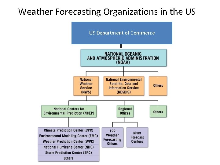
The Weather Business: A Brief Overview • Public Sector: – As stated before, in the US, the governmental agency responsible for gathering and disseminating weatherrelated information is the National Weather Service (NWS), a branch of the National Oceanic and Atmospheric Administration (NOAA). • Private Sector: – In the US, there are many private companies that provide forecasts to the general public, sports teams, airlines, media outlets, oil companies and countless other avenues. – Examples are, CNN, The Weather Channel, Accuweather, USA Today, and subsidiaries of collegiate institutions.

The National Weather Service – The National Weather Service’s Official Mission is the: – Protection of Life and Property • This is the core mission of the NWS. To carry out this duty, the Weather Service prepares and issues a number of important Watch and Warning products to inform the public of impending danger. Some of these products include: Tornado Warnings, Severe Thunderstorms Warnings, Flash Flood Warnings, Winter Storm Warnings, Blizzard Warnings, High Wind Warnings, Tornado Watches and Severe Thunderstorm Watches. • According to FEMA (Federal Emergency Management Agency), 80% of all declared emergencies in the US are weather related. – – Forecast Preparation and Dissemination Support to the Aviation Community Support to the Fire Weather Community Gathering of Data and Maintenance of Climate Records http: //www. wrh. noaa. gov/psr/general/mission/index. php

Forecasting Weather • In the US the National Centers for Environmental Prediction prepares weather maps and charts, and forecasts on a global scale. • This information is then disseminated to 119 Weather Forecasts Offices and private organizations to produce local and regional forecasts • These organizations produce specialized forecasts such as aviation forecasts, forecasts for special events, severe weather warnings, etc. • These forecasts and highly visual forecast tools (maps, charts) are produced largely by non-public funded groups. • The demand for these visual aids ahs grown with the use of personal computers, tablets, smart phones, and TV forecasts • Two major weather centers are operated by the NWS: The Storm prediction Center in Norman, OK and The Hurricane Center/Tropical Prediction Center in Miami, FL

Weather Analysis • A vast network of weather stations is required to provide enough data for a weather chart that is useful for generating even short range forecasts. • On a global scale, the WMO (World Meteorological Organization), an agency of the U. N. , is responsible for the international exchange of weather data. • Surface Collections: Worldwide, over 10, 000 observation stations on land, 700 ships at sea, and 100’s of data buoys and oil platforms report atmospheric conditions each day at 0000, 0600, 1200, and 1800 UTC (Automated Surface Observation Systems) • Observations Aloft: Because the atmosphere is 3 -dimensional, upper-air observations are essential. • Worldwide, nearly 900 radiosondes are launched daily (once at 0600 and 1200 UTC). • Many of these stations are located in the Northern Hemisphere, and most of these are operated by the NWS • However, there are only a few stations in the ocean and in mountainous regions.

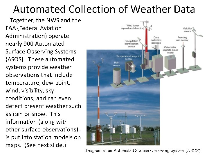
Automated Collection of Weather Data Together, the NWS and the FAA (Federal Aviation Administration) operate nearly 900 Automated Surface Observing Systems (ASOS). These automated systems provide weather observations that include temperature, dew point, wind, visibility, sky conditions, and can even detect present weather such as rain or snow. This information (along with other surface observations), is put into station models on maps. (See next slide. ) Diagram of an Automated Surface Observing System (ASOS)

Weather Forecasting Organizations in the US US Department of Commerce

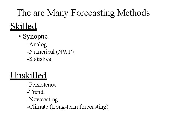
The are Many Forecasting Methods Skilled • Synoptic -Analog -Numerical (NWP) -Statistical Unskilled -Persistence -Trend -Nowcasting -Climate (Long-term forecasting)

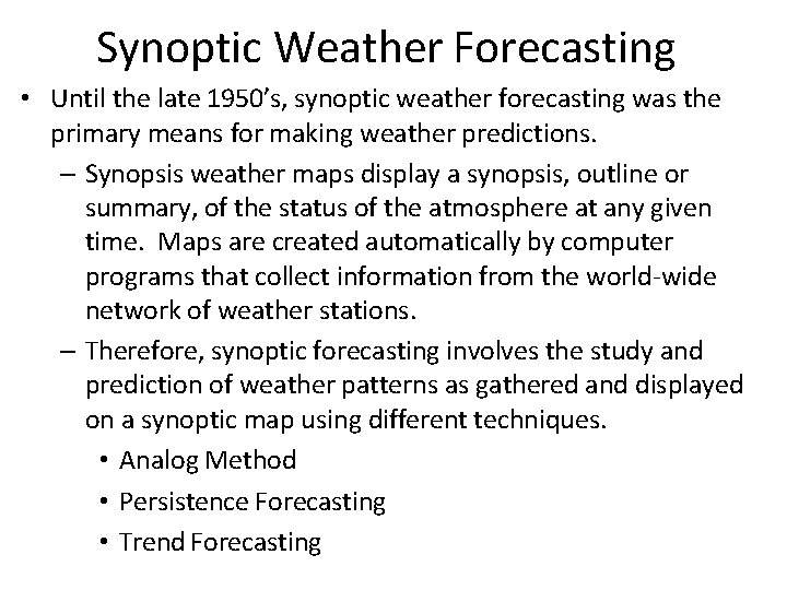
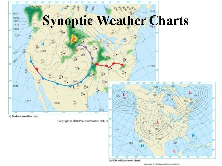
Synoptic Weather Forecasting • Until the late 1950’s, synoptic weather forecasting was the primary means for making weather predictions. – Synopsis weather maps display a synopsis, outline or summary, of the status of the atmosphere at any given time. Maps are created automatically by computer programs that collect information from the world-wide network of weather stations. – Therefore, synoptic forecasting involves the study and prediction of weather patterns as gathered and displayed on a synoptic map using different techniques. • Analog Method • Persistence Forecasting • Trend Forecasting

Synoptic Weather Charts

Synoptic - Analog Method • The analog method involves looking at a developing cyclonic storm and comparing it to the behavior of similar weather patterns from the past. • As this practice became further established, “rules-of-thumb” were established. – A major drawback to this: One needs to be an experienced forecaster to do well. • Perhaps synoptic forecasting is as much of an art as it is a science.

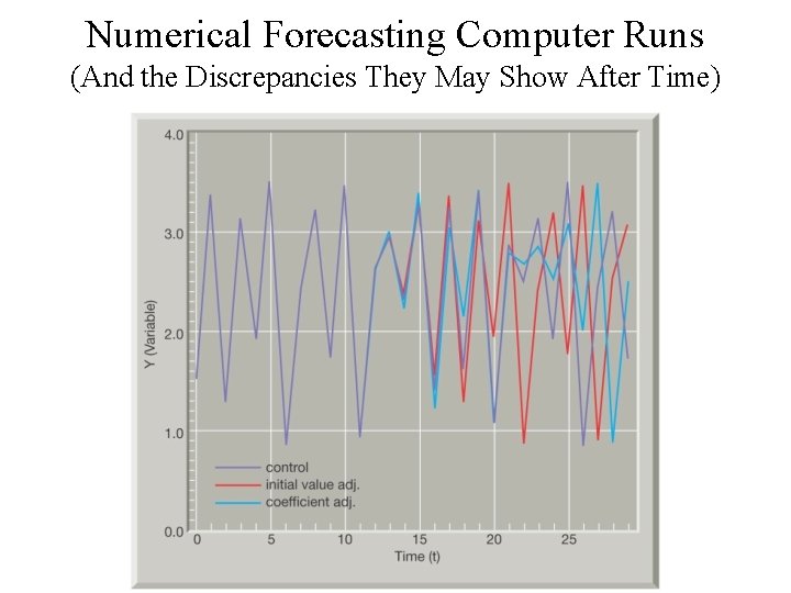
Synoptic - Numerical Method • Modern weather forecasting relies heavily on numerical weather prediction. • Ironically, the word “numerical” is somewhat misleading because all types of weather forecasting relies on some quantitative (numbers) data. • Although complicated, this method employs a number of highly refined computer models that attempt to mimic the behavior of the physical laws of the fluidity of the atmosphere. – Although computers have been refined to tabulate trillions of calculations, slight variations in conditions can produce very different forecasts over time. – Therefore, several runs of the same program are usually performed. – As time has progressed, many models are tweaked to reflect better forecasts

“Progs” • Prognostic charts, or progs, are the predictions maps created from the numerous mathematical model outputs. • Most numerical models are meant to forecast the flow pattern in the air aloft. Some also create forecasts for other conditions such as maximum and minimum temperatures, wind speeds and precipitation probabilities. • After these models are created, the most important factor in forecasts, human beings, interpret these models and use their experience to help modify the predictions. After all, computer models still can’t fully account for a multiple of factors like the influence of some water surfaces, higher terrain, or heat islands from large cities. – A statistical analysis of progs compares the accuracy of previous forecasts. • This approach is known as Model Output Statistics (MOS). • Many models are meant to compare the same data, but given enough time, they sometimes vary greatly. When this happen, forecasters often call for uncertainty in their long range (5 -10 days) predictions.

Numerical Forecasting Computer Runs (And the Discrepancies They May Show After Time)

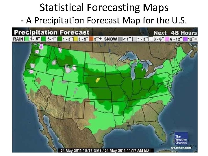
Synoptic - Statistical Method • Statistical methods are used in conjunction with numerical weather predictions. • Past weather data are carefully examined to determine weather patterns that are good predictors of future events. • This is most often used to determine a single aspect of weather; Like daily maximum or minimum temperatures, or daily precipitation totals.

Statistical Forecasting Maps - A Precipitation Forecast Map for the U. S.

Unskilled - Persistence Method • Perhaps the simplest forecasting technique is based on the tendency of the weather at a given site to remain unchanged for several hours, or even a day or so. • Persistence forecasts predict that the future weather will be the same at the present conditions. (i. e. rain now = probable rain in the next few hours. ) – These forecasts do not account for changes in a weather system, or the creation or dissipation in a cyclone. – Therefore, for most areas this is only valid for six to 12 hours, at most 1 day.

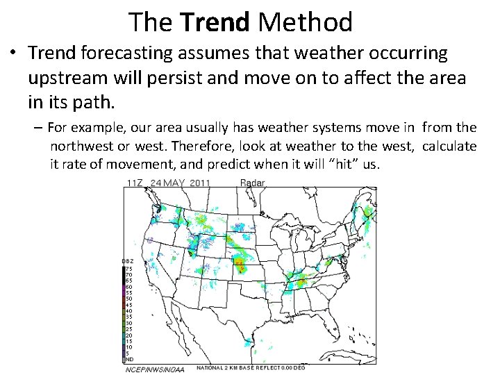
The Trend Method • Trend forecasting assumes that weather occurring upstream will persist and move on to affect the area in its path. – For example, our area usually has weather systems move in from the northwest or west. Therefore, look at weather to the west, calculate it rate of movement, and predict when it will “hit” us.

The Nowcasting Method • Nowcasting is just what it states; a forecast for right now! • It is necessary for severe weather (tornadoes, thunderstorms, and hail) and many other shortlived or small scaled phenomena (lake effect snow) that are too-small to predict accurately in advance. • This technique relies heavily on weather radar and geostationary satellites.

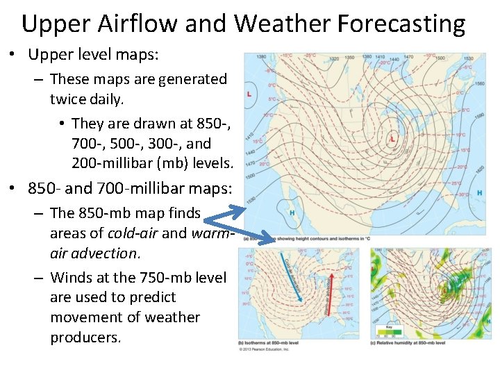
Upper Airflow and Weather Forecasting • Upper level maps: – These maps are generated twice daily. • They are drawn at 850 -, 700 -, 500 -, 300 -, and 200 -millibar (mb) levels. • 850 - and 700 -millibar maps: – The 850 -mb map finds areas of cold-air and warmair advection. – Winds at the 750 -mb level are used to predict movement of weather producers.

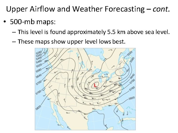
Upper Airflow and Weather Forecasting – cont. • 500 -mb maps: – This level is found approximately 5. 5 km above sea level. – These maps show upper level lows best.

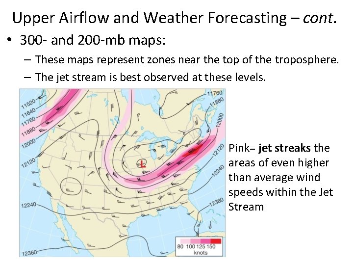
Upper Airflow and Weather Forecasting – cont. • 300 - and 200 -mb maps: – These maps represent zones near the top of the troposphere. – The jet stream is best observed at these levels. Pink= jet streaks the areas of even higher than average wind speeds within the Jet Stream

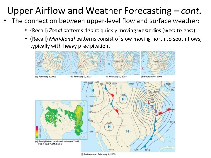
Upper Airflow and Weather Forecasting – cont. • The connection between upper-level flow and surface weather: • (Recall) Zonal patterns depict quickly moving westerlies (west to east). • (Recall) Meridional patterns consist of slow moving north to south flows, typically with heavy precipitation.

Long-Range Forecasts • Long-range forecasting is an area that relies heavily on statistical averages obtained from past weather data, also referred to as climactic data. • They are usually estimates of the precipitation and temperatures that can be expected during long-term periods. • In general, monthly extended forecasts are produced by the following procedures: – 1 st, a mean 700 -mb contour chart is constructed for the coming month. • This is complied by examining the statistical data for the season of the year, and then modifying the data based on the known effects of ocean temperatures (or lake temps in our case), snow cover, and other factors. – 2 nd, Once this map is finished, relations between the flow aloft and the development and movement of surface weather patterns are considered.

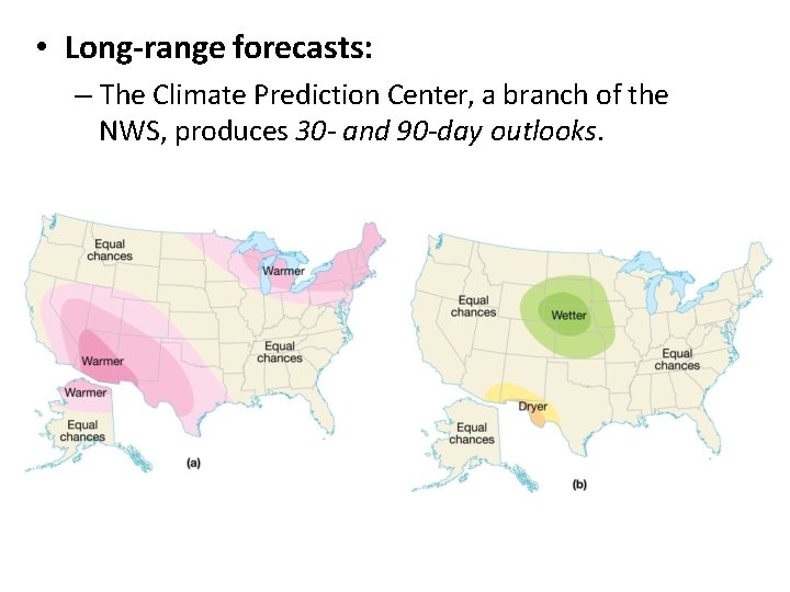
• Long-range forecasts: – The Climate Prediction Center, a branch of the NWS, produces 30 - and 90 -day outlooks.

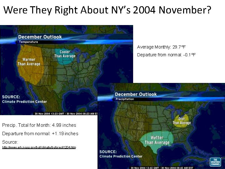
Were They Right About NY’s 2004 November? Average Monthly: 29. 7 ºF Departure from normal: -0. 1 ºF Precip. Total for Month: 4. 99 inches Departure from normal: +1. 19 inches Source: http: //www. erh. noaa. gov/buf/climate/bufprecli 1204. htm

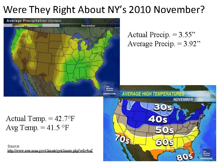
Were They Right About NY’s 2010 November? Actual Precip. = 3. 55” Average Precip. = 3. 92” Actual Temp. = 42. 7°F Avg Temp. = 41. 5 °F Source: http: //www. nws. noaa. gov/climate/getclimate. php? wfo=buf

Forecasting Accuracy • Many of us have heard someone say “I’d like to be a weather man. You can be right 30% of the time, and still keep your job!” • Many argue that meteorologists are often wrong. Thankfully, NWS forecasts have been documented to be correct ≈ 80% of the time (in a nationwide study) in predicting the occurrence of precipitation. • However, skill of its forecasts are acquired over an extended, continuous time, and often take years in one area to be “perfected”. • For example in Western New York there is a lot of influence on the weather from Lakes Erie and Ontario. • It has taken weather people years to accurately be able to predict lake effect snow events

Forecasting Accuracy – cont. • Very short-range (0– 12 hours) forecasts have demonstrated considerable skill, especially for predicting the formation and movement of large weather systems. • Short-range forecasts (12– 72 hours) of maximum and minimum temperatures and wind speeds are quite accurate. Furthermore, predicting precipitation amounts is much better than forecasts made only two decades ago. • Medium-range forecasts (3– 7 days into the future) have shown significant improvement in the last 20 years. • However, the accuracy of day-to-day weather forecasts for periods beyond seven days is relatively unreliable. , especially in mid-latitudes.

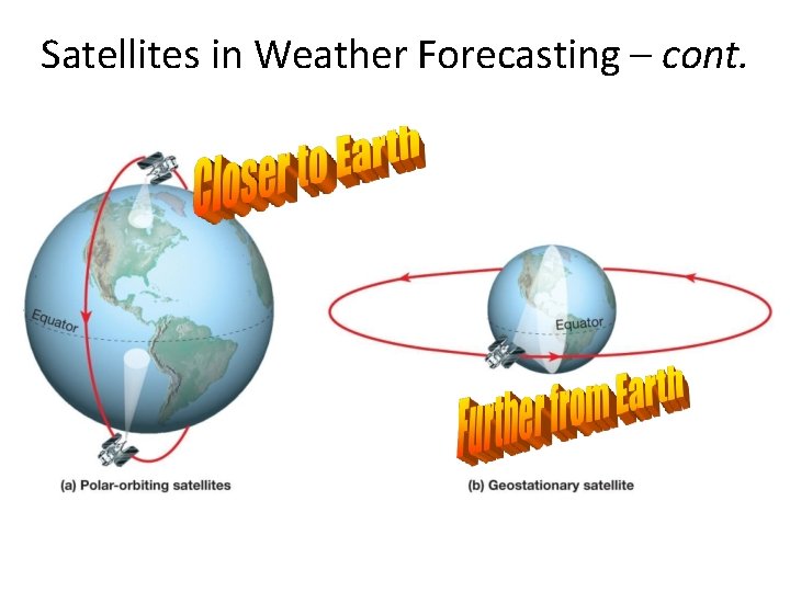
Satellites in Weather Forecasting • TIROS 1: – Launched in 1960, this was the first weather satellite. – Since then, more than 30 versions have been launched through 2016. • Polar-orbiting: – These satellites orbit over the poles. • Geostationary: – These satellites orbit west to east over the equator.

Satellites in Weather Forecasting – cont.

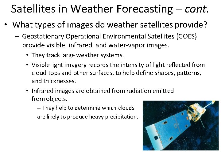
Satellites in Weather Forecasting – cont. • What types of images do weather satellites provide? – Geostationary Operational Environmental Satellites (GOES) provide visible, infrared, and water-vapor images. • They track large weather systems. • Visible light imagery records the intensity of light reflected from cloud tops and other surfaces, to help define shapes, patterns, and thicknesses. • Infrared images are obtained from radiation emitted from objects. – They help to determine which clouds are likely to produce heavy precipitation.

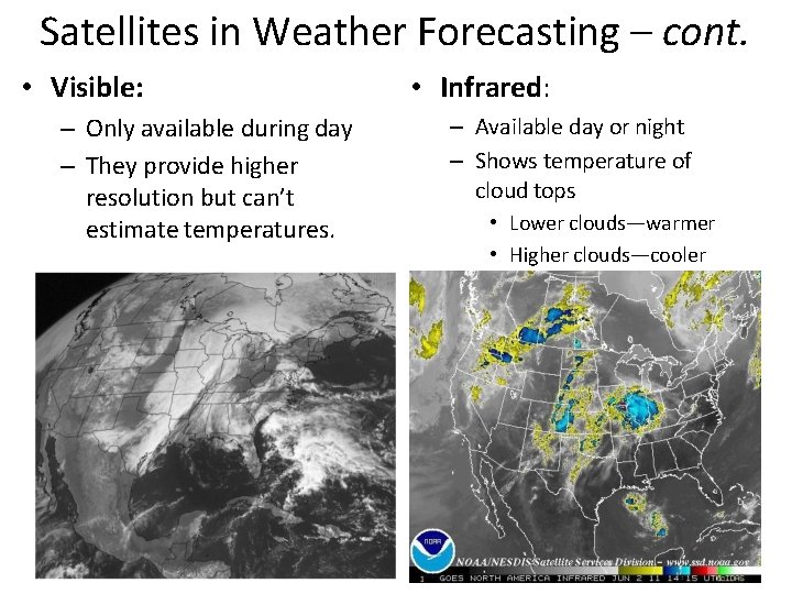
Satellites in Weather Forecasting – cont. • Visible: – Only available during day – They provide higher resolution but can’t estimate temperatures. • Infrared: – Available day or night – Shows temperature of cloud tops • Lower clouds—warmer • Higher clouds—cooler

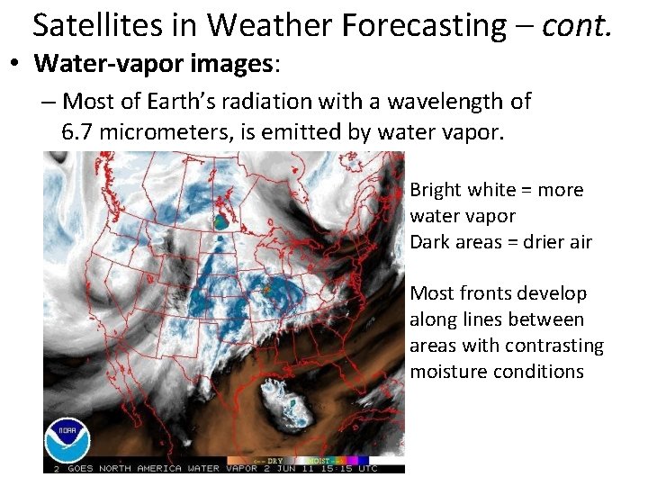
Satellites in Weather Forecasting – cont. • Water-vapor images: – Most of Earth’s radiation with a wavelength of 6. 7 micrometers, is emitted by water vapor. Bright white = more water vapor Dark areas = drier air Most fronts develop along lines between areas with contrasting moisture conditions

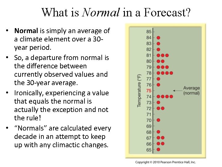
What is Normal in a Forecast? • Normal is simply an average of a climate element over a 30 year period. • So, a departure from normal is the difference between currently observed values and the 30 -year average. • Ironically, experiencing a value that equals the normal is actually the exception and not the rule! • “Normals” are calculated every decade in an attempt to keep up with any climactic changes.