Multicells Lines and Mesoscale Convective Systems METR 1004


 wind flow n The")


")


- Slides: 58
Multicells, Lines, and Mesoscale Convective Systems METR 1004: Introduction to Meteorology Adapted from Materials by Dr. Frank Gallagher III and Dr. Kelvin Droegemeier School of Meteorology University of Oklahoma
Multicellular Thunderstorms So far we have discussed the structure of air mass or single cell thunderstorms. n We can think of these types of storms as a single “cell” where each cell is: n – Independent – Has a complete life cycle – Has a life cycle of 30 minutes to an hour – Is usually weak
Multicellular Thunderstorms n We know that many thunderstorms can persist of longer periods of time. – These storms are made up of many cells. – Each individual cell goes through a life cycle but the group persists. – These storms are called multicellular thunderstorms, or simply multicells – Multicellular storms consist of a series of evolving cells with each one, in turn, becoming the dominant cell in the group.
Multicellular Thunderstorms With air mass storms, the outflow boundaries are usually too weak to trigger additional convection. In multicell storms, the outflow boundary does trigger new convection. Cell #1 Mature
Multicellular Thunderstorms With air mass storms, the outflow boundaries are usually too weak to trigger additional convection. In multicell storms, the outflow boundary does trigger new convection. Cell #1 Mature Cell #2 Cumulus
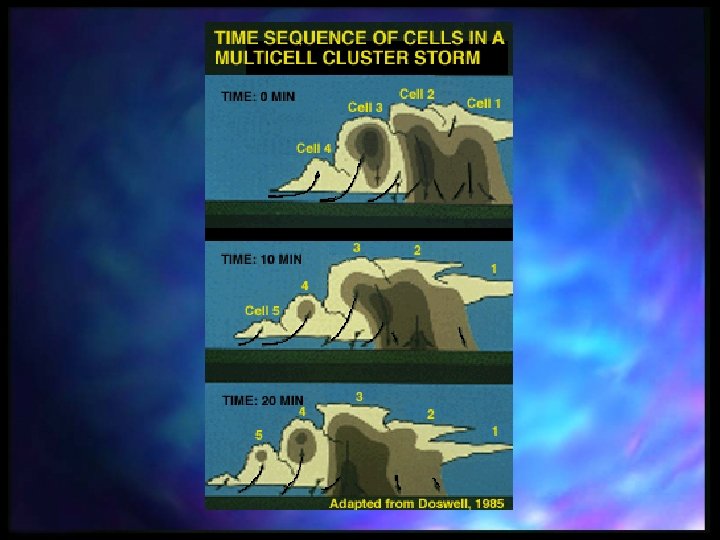
Multicellular Thunderstorms After about 20 minutes or so, the second cell becomes the dominant cell. Cell #1 is now dissipating, and a new cell (#3) is starting. Cell #1 Dissipating Cell #2 Mature Cell #3 Cumulus
Multicellular Thunderstorms After about 20 minutes or so, the third cell becomes the dominant cell. This process may continue as long as atmospheric conditions are favorable for new convection. Cell #2 Dissipating Cell #3 Mature Cell #4 Cumulus Cell #1 Almost Gone
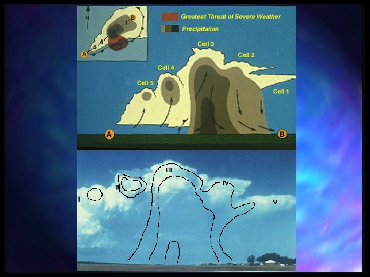
Multicellular Thunderstorms n n A cluster of short lived single cells. Cold outflow from each cell combines to form a much larger and stronger gust front. Convergence along the gust front tends to trigger new updraft development. This is the strongest in the direction of storm motion. New cell growth often appear disorganized to the naked eye.
Structure of a Multicell Storm
Multicell Storm on Radar
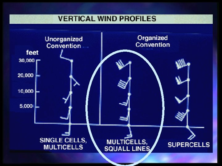
Multicellular Thunderstorms n Conditions for development – Moderate to strong conditional instability n Once clouds form, there is a significant amount of buoyant energy to allow for rapid cloud growth – Low to moderate vertical wind shear n Little clockwise turning
Importance of Vertical Wind Shear n Single cell – Weak shear - storm is vertically stacked – Outflow boundary may “outrun” the motion of the storm cell – New storms that develop may be too far from the original to be a part of it n Multicell – Weak to moderate shear keeps gust front near the storm updraft – triggers new cells – New development forms adjacent to the older cells and connects with the old cell
Cell and Storm System Motion
Multicellular Thunderstorms n n On the previous diagram, there are two arrows that show the “cell motion” and the “storm motion. ” Notice that they are different. Why? New cells tend to form on the side of the storm where the warm, moist air at the surface is located. In the central Plains, this is often on the south or southeast side. 1 Average Wind 2 1 Warm, Moist Surface Air (inflow)
Cell and Storm System Motion
Cell and Storm System Motion
Cell and Storm System Motion
Multicellular Thunderstorms Individual cells typically move with the mean (average) wind flow n The storm system moves differently – by discrete propagation n Multicell storms may last a long time. They constantly renew themselves with new cell growth. n
Multicellular Thunderstorm Hazards n n n Heavy rain -- Flooding Wind damage Hail Lightning Tornadoes -- Usually weak Multicell storms are notorious for heavy rain and hail
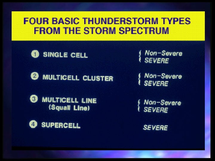
Types of Thunderstorms n Squall lines – – Storms form in a line Can last for several hours Occur all year long Can produce strong winds and hail – Rarely produce tornadoes, except at southern end
Mesoscale Convective Systems Thunderstorm complexes that are larger in horizontal scale than multicellular or supercellular storms. n Examples n – Squall Line Thunderstorms – Mesoscale Convective Complexes
Squall Line Thunderstorms Lines of thunderstorms that tend to act as a single mesoscale system. n May be a continuous line of storms or the storms may be broken into segments. n We classify squall lines according to their development. n
Squall Line Thunderstorms © 1993 Oxford University Press -- From: Bluestein , Synoptic. Dynamic Meteorology in Midlatitudes
Radar Views of Squall Lines
Squall Line on Radar Indianapolis, Indiana 25 July 1986 -- 1714 CST © 1993 Oxford University Press -- From: Bluestein , Synoptic-Dynamic Meteorology in Midlatitudes
Satellite View of a Squall Line
Structure of a Squall Line
Squall Line Passage
Squall Line Cross-section
Arcus Cloud Examples © 1980 The Pennsylvania State University Press -- From: Ludlam , Clouds and Storms Patrick AFB Norman, OK -- 27 May 1977 © 1993 Oxford University Press -- From: Bluestein , Synoptic. Dynamic Meteorology in Midlatitudes
Gustnado Produced by a Squall Line
Squall Line Cross-section n n Precipitation falls into the dry mid-level inflow. The evaporational cooling aids in sustaining a strong downdraft. Often there is a region of lighter precipitation that follows the passage of the squall line > stratiform precipitation. Stratiform Precip.
Precipitation Types Convective (Leading Edge of Line
Precipitation Types Stratiform (Well behind the line)
Stratiform Precipitation Requires rising motion behind the convective towers. n The cloud tops radiate energy to space, thereby cooling the top of the stratiform region. n Radiation from the ground is absorbed by the cloud bases of the stratiform region. n This combination acts to destabilize the atmosphere in the stratiform region. n
Stratiform Precipitation n Updraft – Convective towers: 20 - 50 m s-1 – Stratiform region: 0. 1 - 0. 4 m s-1 n Much slower ascent in the stratiform region. The result is much lighter precipitation.
Mesoscale Pressure Centers n Just behind the gust front is an area of high pressure. This is called a “mesohigh. ”
Mesohigh The mesohigh forms just behind the gust front. n A rapid pressure jump occurs. n Caused by the combined effects of: n – Evaporation of precipitation – Melting of precipitation n These two effects cool the atmosphere to form a dense pool of cold air just behind the gust front.
Mesolow n Behind the stratiform precipitation, a weak low pressure region develops. n Forms probably because of the slowly sinking air behind the stratiform rain. This sinking air warms slightly, creating the weak low pressure. n
Conditions Necessary for Squall Line Development n n Warm, moist air at low levels Relatively cold air aloft Mid-level dry air that can enhance the downdraft and the vigor of the line Environmental cap – Prevents “widespread” convection n “Linear” forcing – Cold fronts, dry line, outflow maxima – Orography, valley wind currents
Conditions for Long-Lived Squall Lines No Environmental Shear – Updraft is Vertical
Conditions for Long-Lived Squall Lines Low-Level Shear Creates a Bias and a Tilt
Conditions for Long-Lived Squall Lines No Environmental Shear – Updraft is Vertical Add Surface Cold Pool – Updraft is Biased and Tilted
Conditions for Long-Lived Squall Lines Low-Level Shear Creates a Bias and a Tilt Low-Level Shear Counters the Cold Pool Bias – Optimal Condition
Conditions for Long-Lived Squall Lines
The Squall Line Bow Echo
Bow Echo on Radar
Visual Siting of a Bow Echo
Mesoscale Convective Complexes n Classification Information – Infrared cloud-top temperatures are colder than -32 o. C and cover an area larger than 100, 000 km 2 – Interior cloud-top temperatures are colder than -52 o. C and cover an area larger than 50, 000 km 2 for 6 hours or more. – Eccentricity greater than 0. 7 at the time of the maximum areal extent of the cloud top.
Mesoscale Convective Complexes MCC
Mesoscale Convective Complexes Often start as a line of thunderstorms that form along the Rocky Mountains. n Move off into the Plains and organize into a much larger system. n Often reach maximum strength at night. n Provide a significant portion of the summertime (warm season) rainfall to the Great Plains. n
Mesoscale Convective Complexes n MCC’s may form structures that resemble smaller scale cyclones. If given sufficient time, they may rotate. The figure on the left shows the remnants of a MCC. The cyclonic rotation is clearly evident on this visible satellite image. Note that the size of the vortex covers almost all of Kansas and Oklahoma!
Mesoscale Convective Complexes As with squall lines, MCCs have strong convective updrafts and regions of slowly ascending air that creates the stratiform precipitation. n The difference is that in the MCC the slowly ascending updrafts tend to surround a central core of convective updrafts. n
Mesoscale Convective Complexes n n MCCs are producers of – Heavy Rain – Flash Floods – Hail – Frequent Lightning – Possibly a tornado if the environmental shear is sufficient MCC storms may last for 12 or more hours. They act to restabilzed a conditionally unstable atmosphere. They may set up surface boundaries that can influence weather a day later.