Geology 12 Presents UNIT 3 Chp 10 Earths





- Slides: 91

Geology 12 Presents

UNIT 3 • • • Chp 10 Earth’s Interior and Isostacy Chp 11 Ocean Basin Chp 12 Plate Tectonics Chp 9 Seismology Chp 13 Structure Handout WS 10. 1 Note Helper

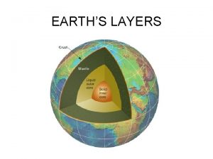
Earth’s Interior and Isostacy As th en os ph er e Outer Lower core mantle Inner core Lithosphere Chapter 10 atmosphere continental crust hydrosphere oceanic crust Moho Upper mantle

Earth’s Interior


Layer Vol % Density gms/cm 3 Oceanic Crust 0. 16 3. 0 Continental Crust 0. 44 2. 7 Composition upper: basalt lower: gabbro granodiorite Mantle 83 3. 3 – 5. 7 peridotite Outer Core 15. 7 9. 9 – 12. 2 Inner Core 0. 7 12. 6 – 13. 0 80 - 90% Fe, +Ni 88%Fe, +S, O 2, Ni, K


How Layers of Earth was Determined 1. 2. 3. 4. Seismic Heat Flow Gravity Magnetic Field

1. Seismic • Seismic waves that travel through the Earth • Caused by earthquakes or underground nuclear tests • Two types 1. Surface waves 2. Body waves

1. Surface Waves – Travel on the surface – 2 -3 km/sec • Rayleigh and Love waves (more on this in Chp 9) Surface waves EQ Body waves

1. Surface Waves – Travel on the surface – 2 -3 km/sec • Rayleigh and Love waves (more on this in Chp 9)

2. Body Waves – Travel inside the Earth – a) P-waves/Primary waves • Fastest (7 -13 km/sec) • A compressional/pull-push wave like sound • Travel through everything (rock, magma, water, air ( can sometimes hear EQ!)


– B) S-waves/Secondary waves • slower (3 - 7 km/sec) • Are shear waves because they move perpendicular to direction of travel • Travel only through solids (not fluids)


• Wave velocity affected by: i) rock density: higher density speeds waves (ex: Earth’s density increase towards the core: S-waves travel faster at the bottom of the mantle) ii) Rock elasticity = tendency to return to original shape higher elasticity increases wave speed (ex: P-waves travel slow through liquid outer core than through solid inner core) v. Discontinuity = marked change in wave velocity • Basis for dividing Earth into its layers.

• Please now refer to WS 10. 1 top of page 2 of note helper

Gutenburg Discontinuity Low velocity zone = asthenophere crust


• Upon EQ/nuclear detonation, waves travel outward and inward in every direction (like ripples on a pond) • Waves’ direction of travel: – Refracted (bent) away from more dense/more elastic rocks back to surface • Most energy is refracted – Reflected (change direction) at major rock boundaries (discontinuities) • Reflected waves (wave velocity) + time to travel = depth to layer) gives us depth to layers (d = vt) • GEOPHYSICS

EQ Wave Reflection Wave Refraction

Layers of the Earth Found • 1. Core – a) Outer Core & S-waves Liquid Outer

b) Inner Core & P-waves • Inner core is solid because higher pressure increases melting temperature • Inner core rotates 20 km/yr faster than outer core


2. Mantle • 1909 Andrija Mohorovicic detected a seismic disontinuity (Moho) at about 30 km.

• P-waves travel faster (8 km/sec) in mantle than in crust (6. 75 km. sec) • Moho – bottom of crust – Below continents: 2 - 90 km (aver’ 35 km) – Below seafloor: 5 -10 km. Please refer to WS 10. 1, p. 2 of notehelper, bottom diagram.


Upper mantle M . Transition Zone Lower Mantle C . Low velocity zone = Asthenosphere

Upper Mantle

Seismic Tomography • Numerous seismic waves are analyzed to give a “CAT-scan” of the Earth • Hot and cold areas of the mantle have been detected by measuring wave velocities (hot rock is less elastic = lower velocity) • Depressions and rises have been detected where rising and sinking mantle deforms the mantle and core.

Seismic Tomography


3. Crust • a) Continental Crust: – mainly granodiorite (P-waves 8 km/sec) – 35 km aver’ thickness – 20 km at rifts – 90 km at Himalayas

• b) Oceanic Crust – Top 1/2 : basalt – Bottom ½: gabbro – 5 km thick at spreading ridges – 10 km thick where it is oldest

3. Crust


How Layers of Earth was Determined 1. 2. 3. 4. Seismic Heat Flow Gravity Magnetic Field Hand out WS 10. 2 Note Helper

2: Heat Flow • Is very low (Earth is a good insulator/poor conductor) • Is measured with very sensitive instruments


Heat flow Cal/cm 2/sec • Highest at spreading centres and areas of recent volcanism; lowest at trenches 4 3 2 Oceanic ridge Island arc (volcanoes) World average 1 0 trench old crust new crust

• 70% of heat is lost through oceans • Earth has been cooling off (less and less radioactive fuel) since its beginning. • Most heat created by radioactive decay of U, Th and K


• Geothermal Gradient = rate of increase in temperature with depth Remember Chp 7! – Highest at spreading ridge; lowest in mtns’ Region Temperature Crust base: 800 - 1200 Mantle base: 3500 -5000 Core base: 6500 Geothermal Gradient 25 1 <1

How Layers of Earth was Determined • • Seismic Heat Flow Gravity Magnetic Field


3: Gravity • Exists because mass attracts mass • We are attracted towards the centre of the Earth m 1 x m 2 • F = G d 2 Double the distance = ¼ the gravity

• Gravity varies by: 1. Distance between masses (greater distance = less gravity a) Earth is not round: less gravity at equator 6357 km 6378 km

b) less gravity at high altitudes

2. Centrifugal force at equator “throws” you away from Earth = less gravity • Generally. Gravity varies with latitude and altitude

3. Density of rock below • Gravity is measured with a gravimeters (Positive gravity anomaly = more gravity) • Important for Olympic records • If you want to weigh less: – Drive fast east at the equator on top of a mountain over top of low density rock.


Centrifugal Force is seen here with indirect high tides


l Please refer to WS 10. 2 Note Helper, bottom of page 1.

Positive gravity anomaly Negative gravity anomaly Mountain Ore deposit Low density sedments Salt dome (low density

• Principle of Isostacy is Earth’s crust is “floating” on denser mantle. – Like an iceberg, only 10% is above the water no matter the size of the iceberg Mountain Crust Mantle root


Isostacy


• Crust floats like a raft: – It sinks if: a) glaciers/ice age b) sediments accumulates in a delta or basin (Evidence: sunken cities, docks, forests, beaches) – If rises = isostatic rebound if: a) glaciers melt/recede b) erosion of a mountain (Evidence: above sea-level: docks, beaches, marine fossils)

1. 2. 3. 4. Glacial ice Ice melts (i. e. Hudson’s Bay

Mtn’ Low density root erosion deposition erosion deposition


See question 11, WS 12. 2

See question 16, UNIT 3 Review WS

How Layers of Earth was Determined • • Seismic Heat Flow Gravity Magnetic Field

4. Magnetic Field • Earth is dipolar = N & S pole • Magnetic Filed is generated by electric currents in outer core • Rocks with magnetic substances (iron, nickel) that cool below the Curie Point (580’C for magnetite) “lock-in” the present magnetic field.

4. Magnetic Field

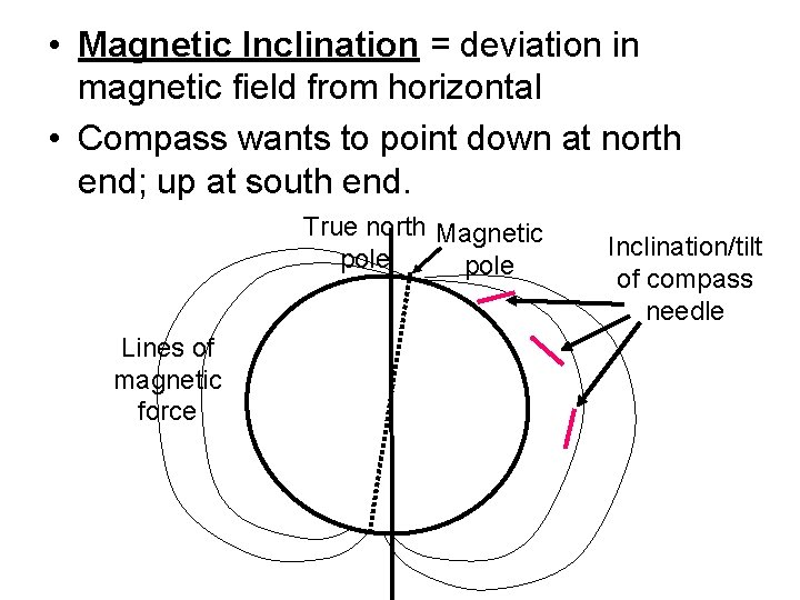
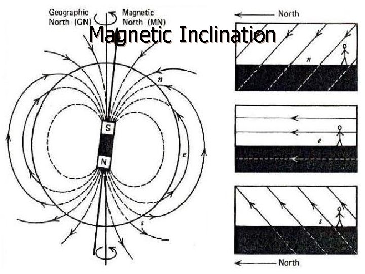
• Magnetic Inclination = deviation in magnetic field from horizontal • Compass wants to point down at north end; up at south end. True north Magnetic pole Lines of magnetic force Inclination/tilt of compass needle

• Inclination can tell us the latitude of the continents/terranes at the time of Curie. – i. e. many of the BC terranes formed about 30’ latitude.

Magnetic Inclination

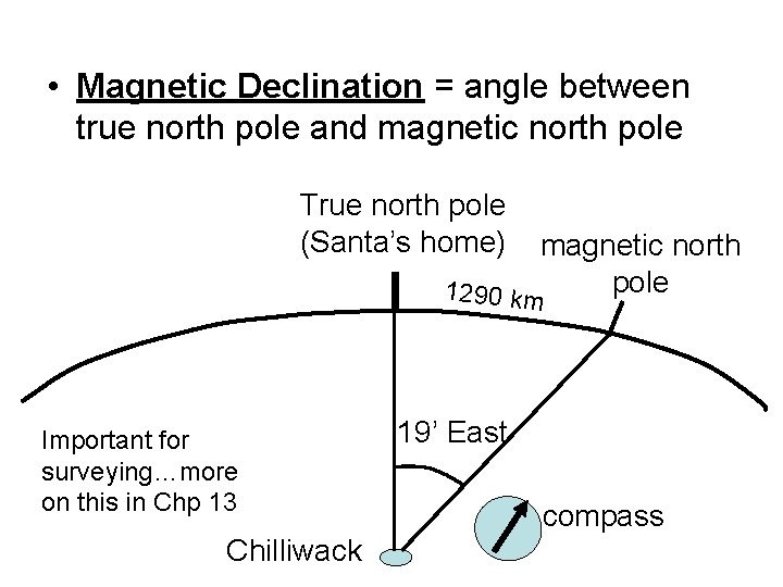
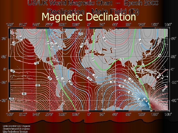
• Magnetic Declination = angle between true north pole and magnetic north pole True north pole (Santa’s home) magnetic north pole 1290 km Important for surveying…more on this in Chp 13 Chilliwack 19’ East compass

Magnetic Declination


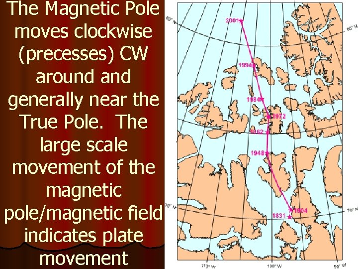
The Magnetic Pole moves clockwise (precesses) CW around and generally near the True Pole. The large scale movement of the magnetic pole/magnetic field indicates plate movement

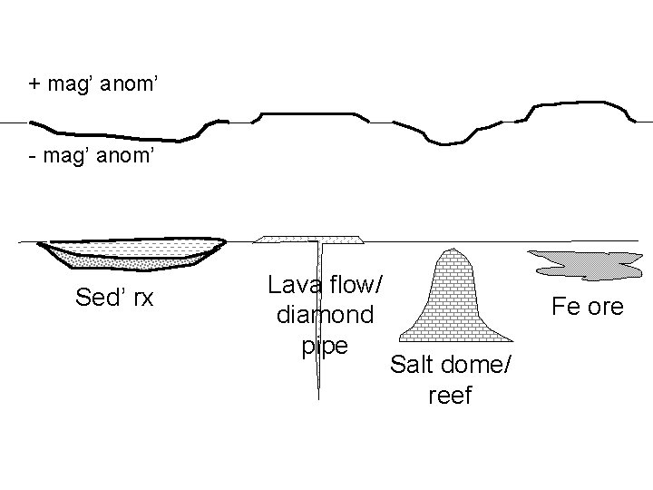
• Magnetic Anomalies = variations in normal strength of magnetic field – Measured with magnetometer. – Positive anomaly = stronger magnetism • Iron ore area (Great Lake region) • Lava flows (mafic rx) (Columbia basalts) • submarine, ship • Diamond mine/volcanic pipe – Negative anomaly • Sedimentary rock • Salt dome, coral reef See WS 10. 2 Note helper, top of page 2.

+ mag’ anom’ - mag’ anom’ Sed’ rx Lava flow/ diamond pipe Fe ore Salt dome/ reef

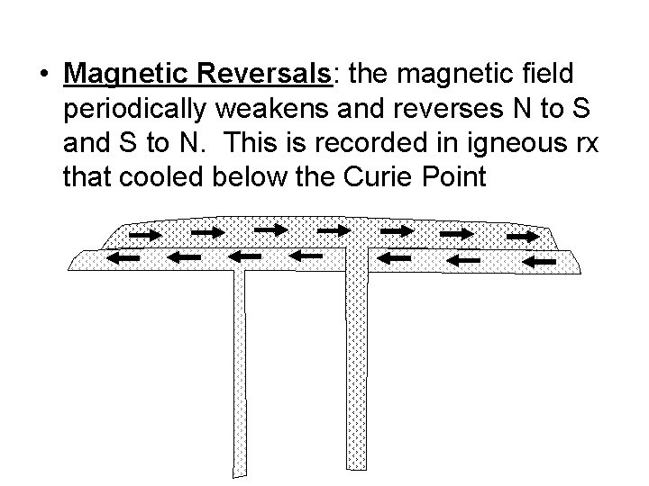
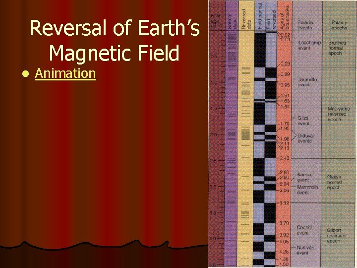
• Magnetic Reversals: the magnetic field periodically weakens and reverses N to S and S to N. This is recorded in igneous rx that cooled below the Curie Point

• The magnetic field has weakened 5% in the last 100 yrs (15% in last 200), and is predicted to be nil in a few 1000 years, then will reverse, and build up again. – Last switched 70, 000 yrs ago. • Paleomagnetism: study of ancient magnetism.

Reversal of Earth’s Magnetic Field l Animation

l Do WS 10. 3 l Look at Unit 3 Review WS. There is a “bottleneck” at the end of Unit 3, so do NOT leave the Unit 3 Review WS to the last few days. You have been warned!
 Chp bit inspection
 Hardvarf
 Market research igcse
 Acute variables of training
 Mattew chapter 5
 Basic hand tools list
 Vision statement keywords
 Double ended queue
 Chp 14
 Chp dre
 Selección natural ejemplos
 Checed warwick apartments
 Earth layers foldable
 Earths roation
 Whats earths moon called
 What makes one biome different from another?
 Most common elements in the earth's crust
 Basalt
 Whats earths moon called
 Which layer of the earth slowly moves like putty
 Earths early atmosphere contained
 The earth's layer foldable
 Earths major crustal plates
 Earths orbit seasons
 Brown earth soil profile
 Study of the earth's physical features
 Earth's honey
 Whats the name of earths moon
 Continental drift theory notes
 Earths crust
 Where
Where Spring earth tilt
 We live in this layer of the atmosphere.
 Describe the true shape of earth's orbit
 Earths kayers
 What does earths tilt do
 Earths boundaries
 4 spheres of the earth
 What is font
 Presents from my aunt in pakistan
 Presents from my aunts in pakistan
 Sally elatta presents on business agility
 16 3 darwin presents his case answer key
 Section 15–3 darwin presents his case
 Zids and zods answers
 A text that presents both side of the topic
 Zids and zods answers
 Prose writing that presents and explains ideas
 What is nonfiction prose
 Gurmit paid £21 for five presents
 Shona quiz
 Jesus roi des rois qui mourut pour moi
 Thesis main idea
 A 26 year old female presents
 This presents
 A dramatic work that presents the downfall of a character
 What element creates the tone and presents the characters
 Sue palmer discussion book
 Shcedules
 Is the way an author presents a character.
 Which option presents a clear point of view?
 A thesis statement presents
 Which sentence presents a faulty either/or argument?
 Chapter 17 neurologic emergencies
 Unit 6 review questions
 Geology is the study of
 Uw
Uw Geology what is
 Geology
 Stratigraphy
 Geology lecture series
 Geology grain size card
 Types of differential stress
 Regolith geology
 Regolith geology
 Arizona state university geology
 Strike and dip vs. trend and plunge
 Geology of cuba
 Aquitard definition geology
 Geology of maui
 Thrust geology
 Outcrop patterns
 Gcse geology data sheet
 Gcse geology
 Seismic beach balls
 Compressional stress
 Structural geology
 Mohr's circle
 Geology earth science definition
 Parallel extinction
 Astronomy definition earth science
 Earth science vs geology


