Plate Tectonics Why Do the Continents Look The


- Slides: 32
Plate Tectonics!
Why Do the Continents Look The Way They Do? • In 1912, a German scientist, Alfred Wegener, proposed a hypothesis called continental drift. • Continental drift stated that the continents had moved from their original positions.
Continental Drift • Wegener said that the continents had been part of a single land mass called Pangaea surrounded by a single sea called Panthalassa. • According to his hypothesis, about 200 million years ago, Pangaea started to break up into smaller continents and drift to their present locations. • He also said that the movement may have crumpled the crust in places producing mountains.
Pangaea
Evidence of Continental Drift? • The coastlines of the continents line up. • Fossils of the same plants and animals are found on different continents. • Rock age and type along coastlines also are very similar. Mountain chains line up with each other. • Climate patterns are similar • Seafloor spreading
Seafloor Spreading? • In 1947, a group of scientists set out to map the Mid. Atlantic Ridge, an undersea mountain range with a steep, narrow valley running down its center. • The scientists found that the ocean floor was very young compared with the age of continental rocks. None of the rocks were more than 150 million years old, yet the oldest continental rocks were about 4 billion years old.
The Hypothesis: Seafloor Spreading • “Suppose that the valley at the center of the ridge was actually a break, or rift, in the earth’s crust and that molten rock, or magma, from deep inside the earth was welling up through the rift. This upwelling would be possible if the ocean floor was moving away from both sides of the ridge. As the ocean floor moved away from the ridge, it was replaced by rising magma that cooled and solidified into new rock. ” --Harry Hess
Seafloor Spreading • If the ocean floor was moving, the continents might also be moving. • Perhaps seafloor spreading was the force that made Pangaea break apart. • The seafloor spreading hypothesis has since been proven because of magnetism.
Magnetism of Rocks on the Ocean Floor • When magma cools and hardens, certain iron-bearing minerals within the rock become magnetized. When the rock hardens, the magnetic orientation of the minerals becomes permanent and points to the north. • As scientists investigated, they realized that the magnetic orientation sometimes pointed south. This means that the polarity of the earth sometimes reversed.
• In 1965, two different groups of scientists discovered that the magnetism had been reversed both on land on the ocean floor in patterns. The dates and pattern of the reversal were exactly the same. • This means that theory of continental drift was true and that seafloor spreading due to magma was how the continents were moving apart from each other. Magnetism
The Theory of Plate Tectonics • Theory of Plate Tectonics describes continental movement and gives a possible explanation of why and how continents move. • Tectonics is the study of the formation of features in the earth’s crust. • There are two types of crust on the earth… • Oceanic crust – material on the ocean floor • Continental crust – continental landmasses
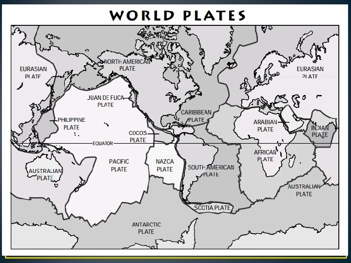
Earth’s major plates
Lithosphere vs. Asthenosphere • Lithosphere – the oceanic and continental crust and the upper mantle. This forms the thin outer shell of the earth. • Asthenosphere – the layer beneath the lithosphere – a layer solid rock that slowly flows (like putty) when under pressure.
Theory of Plate Tectonics • According to theory of plate tectonics, the lithosphere is broken into separate plates that ride on the denser asthenosphere. • The continents and oceans are carried along as “passengers” on the moving lithospheric plates. • Most lithospheric plates are composed of both continental and oceanic crust. • To date, 30 lithospheric plates have been identified. These plates make up the earth’s features (mountains, trenches, oceans, etc. )
Lithospheric Plate Boundaries • Many changes in the earth’s crust originate along lithospheric plate boundaries. • The boundaries are not easy to identify. • There are three main types of boundaries… • Divergent boundaries • Convergent boundaries • Transform fault boundaries
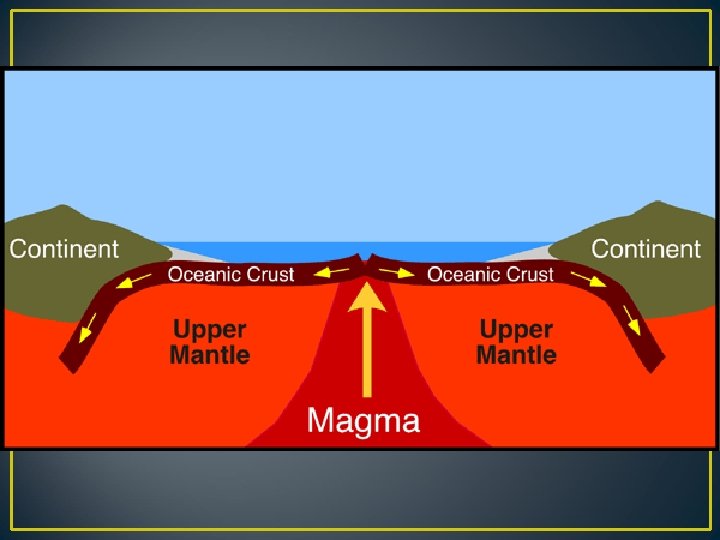
Divergent Boundaries • Divergent boundaries are formed when two plates are moving away from each other. • As the plates move apart, molten rock from the asthenosphere rise and fills the space between the plates. • As the rock cools, it hardens onto the edges of the separating plates and creates new oceanic crust. • Most divergent boundaries are located on the ocean floor.
• In the center of a midocean ridge is a narrow valley formed as the plates separate. • This formation is called a rift valley. • Other rift valleys may form where continents are separated by plate movement. • Example: The Red Sea occupies a huge rift valley formed by the separation of the African plate and the Arabian plate. Rift Valley
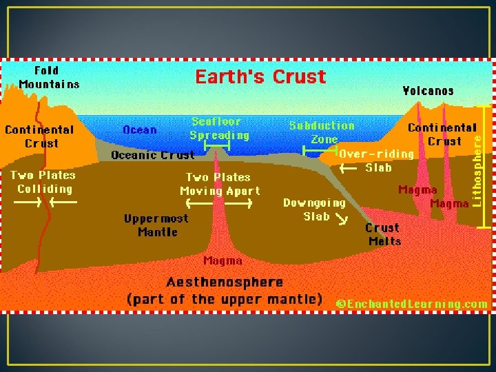
Convergent Boundaries • Convergent boundaries are formed at direct collisions of one plate with another plate. • There are three types of collisions that can happen at convergent boundaries. 1. Oceanic crust collides with a continental crust: subduction zone. 2. Two continental crust plates collide: 3. Two oceanic crust plates collide: Deep ocean trench is formed. Part of the subducted plate melts, molten rock rises, and the surface along the trench forms a chain of volcanic islands called an island arc.
Convergent Boundaries • Oceanic crust collides with a continental crust: subduction zone. One plate moves under another plate. This heats and melts rock layers to form the parent material for igneous rock.
Convergent Boundaries • Two continental crust plates collide: This produces mountain ranges.
Convergent Boundaries • Two oceanic crust plates collide: Deep ocean trench is formed. Part of the subducted plate melts, molten rock rises, and the surface along the trench forms a chain of volcanic islands called an island arc.
Transform Fault Boundaries • A transform fault boundary forms where two plates are grinding past each other. • The plate edges usually do not slide along smoothly. • They scrape together and move in a series of sudden spurts of activity separated by periods of little or no movement. • Example: San Andreas fault line in California
Fault Lines in North Carolina
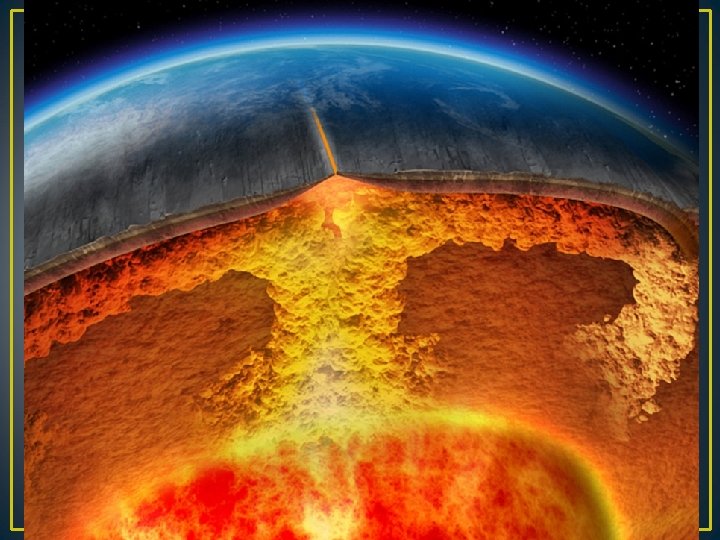
Causes of Plate Motion • Many scientists think that the movement of lithospheric plates is due to convection. They are not 100% sure that this is what happens! • Convection is the transfer of heat through the movement of heated fluid material. – Example: boiling water on a stove – The cycle of warm water rising and cool water sinking to replace it is called convection current. • Scientists think the same thing happens in the atmosphere.
Suspect Terranes • Theory of Suspect Terranes helps to explain how the continents were formed. • This theory suggests that the continents are actually a patchwork of terranes – pieces of lithosphere, each with its own distinct geologic history. • Each terrane has three identifying characteristics. – Rock and fossils that are different from neighboring terranes – Major faults at the boundaries – Magnetic properties of a terrane do not match those of neighboring terranes
Suspect Terranes
Color and Label the Map