AP HUMAN GEOGRAPHY EXAM REVIEW The AP Exam


 Discuss ONE positive impact of EACH country’s population structure on")
 Discuss ONE negative impact of EACH country’s population structure on")


 International")


- Slides: 33
AP HUMAN GEOGRAPHY EXAM REVIEW
The AP Exam 2 hrs, 15 mins Section 1: MCQs � 60 minutes � 75 questions Section 2: FRQs � 75 minutes � 3 questions 50% MCQ 50% FRQ
Section 1: Multiple Choice Tips Scores are based how many you get right No points are deducted for wrong answers So ANSWER EVERY QUESTION- don’t leave any blank!
Section 1: Multiple Choice Tips Read carefully! Eliminate as many answer choices as possible
Section 2: Free Response Questions You have 75 minutes to answer all 3 questions You should spend 25 minutes on each Read the question carefully before you answer.
Section 2: Free Response Questions You must write in complete sentences, but it does not need to be a formal essay. If you are given three parts to a question (A, B, C…) organize your answers in the same way You may NOT bullet your answers… even if they ask to “list”. If asked to list one and you list two, the second will not be graded. So develop first point.
Practice FRQ: 2010
The population pyramids above represent two countries at different stages of the demographic transition and economic development. Part A (2 points) Explain the demographic characteristics of each country above with respect to the demographic transition model. • Must mention Stage 2 (second or early expanding stage) AND elaborate briefly about its characteristics, such as high birth rate, falling death rate, youthful population, developing country. Country A • It is not acceptable to suggest Stages 1 or 3 for Country A. • Must mention Stage 4 (fourth, final, or low stationary stage) AND elaborate briefly about its characteristics, such as low birth rate, low death rate, aging population, developed country. Country B • It is acceptable to mention a possible Stage 5 (fifth stage) for Country B.
Part B (2 points) Discuss ONE positive impact of EACH country’s population structure on its economic development. Country A • Expanding or large workforce (1 point) • Youthful population, which can spark creativity, receptivity to change, etc. • Less need for immigrant labor • Less need for elder social safety net (e. g. , Social Security) Country B • Educated (skilled, experienced, etc. ) workforce (1 point) • Low youth dependency ratio • More women in the compensated workforce • Tendency to spend discretionary income on needs other than education • Might need immigrant labor, which would allow citizens to take higher-order jobs
Part C (2 points) Discuss ONE negative impact of EACH country’s population structure on its economic development. Country A • High youth dependency ratio (1 point) • Strain on resources, the environment or society owing to rapid population growth • Low literacy rate for women • Fewer women in the compensated workforce Country B • High elder dependency ratio (1 point) • Possible future labor shortage • Greater need to fund elder social safety net (e. g. , Social Security)
Exam Scores 5 • Extremely Well Qualified • = an A in college 4 • Well Qualified • = a B in college 3 • Qualified • = a C in college • Possibly Qualified • =a. D 2 1 • No recommendation
www. collegeboard. org
UNIT 1 GEOGRAPHY: ITS NATURE AND PERSPECTIVES 5 -10% of the AP Exam
The 5 Themes Location Place Human/Environment Interaction Movement Regions
The 5 Themes Location � Absolute � Relative Place Human/Environment Interaction Movement Regions
The 5 Themes Location Place � Toponyms- place names � Site- location based on characteristics � Situation- relative location Human/Environment Interaction Movement Regions
The 5 Themes Location Place Human/Environment Interaction Movement � Migration � Communication, Regions transportation, trade
The 5 Themes Location Place Human/Environment Interaction Movement Regions � Formal � Functional � Perceptual
Scale • • Small scale = small detail Large scale= large detail
Large-scale Small-scale
Important lines of latitude Equator: Equator 0 degrees Tropic of Cancer: 23. 5 degrees North Tropic of Capricorn: 23. 5 degrees South Arctic Circle: 66. 5 degrees North Antarctic Circle: 66. 5 degrees South Parallels are circular lines used to indicate latitude
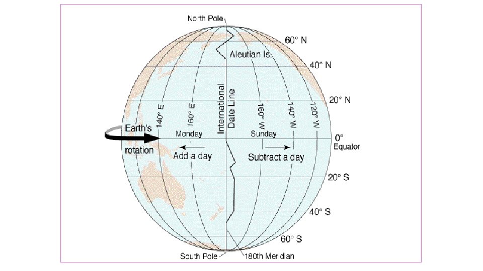
important lines of longitude Prime Meridian: Meridian 0 degrees (runs through Greenwich, England) International Dateline: Dateline 180 degrees Time Zones: Zones every 15 degrees of longitude equals
Time Zones http: //www. timezonecheck. com/ http: //www. bbc. co. uk/news/world
Geographic Information System: a collection of computer hardware and software that permits storage and analysis of layers of spatial data.
Space-Time Compression, 1492 -1962 The times required to cross the Atlantic, or orbit the earth, illustrate how transport improvements have shrunk the world.
When contact diminishes with increasing distance and eventually disappears. Distance Decay
Thematic Maps Dot Map Contour or Isoline map Cartogram map Proportional symbol map Cloropleth map Flow line
World Population Cartogram
Space: Distribution of Features Spatial Distribution—The regular arrangement of a phenomenon across Earth’s surface. Three features � (1)Density � (2)Concentration � (3)Pattern
Diffusion • The process by which a characteristic spreads across space and over time • Hearth = source area for innovations • There are two main types of diffusion – – (1)Relocation (2)Expansion
The Cultural Landscape A unique combination of social relationships and physical processes Each region = a distinctive landscape People = the most important agents of change to Earth’s surface