POTENTIAL METHODS 2018 2019 Part 5 Gravity data



- Slides: 86

POTENTIAL METHODS 2018 -2019 Part 5 Gravity data acquisition Carla Braitenberg Trieste University, DMG Home page: http: //www 2. units. it/~braitenberg/ e-mail: berg@units. it 1

Measuring techniques of Grav. Mag fields Steps to consider if new data are needed: Determine size of area to be studied. Also size of expected signals. Small size: high accuracy, high spatial resolution • Terrestrial measurements: best quality. Small sampling distance. Time consuming. • Gravity: levelling and near topography measurement • •

Definition of resolution • Minimum half-wavelength that can be mapped in a survey, provided amplitude of signal exceeds accuracy limits of observations. • Resolution depends on data interval on landbased observations. • Moving platform (marine vessel, aircraft, satellite): measurement interval may be much smaller than final observation interval, because data must be filtered over consecutive observations to eliminate noise. 3

Why is height measurement important? • Remember: dz = 1 m -> 0. 3 mgal signal • Microgravimetry: µgal -> 0. 3 cm height accuracy needed • The height of the measured point must be determined in arallel to the gravity measurement. • GPS: very fast. Differential GPS. Precision of some cm on z component. • On magnetic field: height less problematic. 4

Where to obtain data? • BGI: Bureau Gravimetrique International • Example Africa: see figure • Other sources: – National geological surveys – Private data distribution centers 5

BGI public data - Italy 6

BGI public and private data N-Africa 7

Airborne measurements Independent on terrain Regular spacing of measurements Fast measurement Continuous recording To be corrected for vertical movements of aircraft • Greater distance from source. • Practical: can microgravity measurements be made? • • • 8

Shipborne measurements • Horizontal ship movement slow with respect to vertical movement. • Technique of averaging in time eliminates noise due to waves. • Instruments can be installed routinely on vessels cruising for seismics. Measurements can be made automatically. Data analysis can be done later. 9

Height for ship-borne observations • Mean sea level and geoid differ little: height measurements unnecessary. 10

Satellite measurements • • Greater distance from source Spatial resolution is worse. Global availability Altimetric satellites: – ERS, Topex, Jason, Envisat – Measure sea level height. – Sea level close to geoid – Gravity field can be derived. 11

Altimetric measurements • Up to a few km from coast good quality data claimed in the newest releases: lesser data due to footprint interference with coast. • Degraded results over shallow seas: currents are important and sea surface deviates from geoid: dynamic topography of sea surface. But in the 20 years analysis of the altimetric field and comparison with independent measurements as ocean drifters and gravity measurements on ships, the ocean current models have been successively improved, so that the dynamic topography can be modelled and subtracted from the observations leading to a correct gravity field. 12

Geodetic satellites • Geodetic satellites: deviation of orbit from predicted. Acceleration and gradiometer measurement on board. • Satellites: GOCE, GRACE-Follow-On 13

Amplitude-Frequency of gravity field: measurements of gravity are static or the time-variable field is observed. Many interesting dynamic phenomena can be observed. 14

The relative gravimeters achieve higher accuracy than absolute measurements. In figure: SG: superconducting gravimeter. AG: absolute free fall gravimeter 15

The measurement of gravity: What do we want to measure – let’s recall the equations. - gravitational law G= 6. 67 10 -11 m 3 kg-1 s-2 SI: gravity acceleration g measured in ms-2 1 µm s-2 = 10 -6 m s-2 and 1 nm s-2 = 10 -9 m s-2 Old: 1 Gal = 10 -2 m s-2 = cm s-2 1 m. Gal = 10 -5 m s-2 = 10 µm s-2 1 µGal = 10 -8 m s-2 = 10 nm s-2 16

- height dependence: the vertical gradient of gravity -For the Earth the variation is, with h height (m) above geoid or ellipsoid (according to the reference system): ± 0. 01 m. Gal corresponds to ± 3 cm height difference 17

- mass dependence - Gravitational attraction of a plate Plate thickness of 1 m leads to (density : 2670 kg m-3) or 112 µGal Conclusion: The Bouguer effect is about 1/3 of the height effect and has the opposite sign. 18

- time dependence Three different effects: (1) (2) (3) drift of gravimeter elevation and / or mass changes earth tides (1) Drift properties (or stability of gravimeter spring and electronics) individual gravimeter, temperature stabilisation / outer temperature handling of the gravimeter (transport conditions). (2) Repeated microgravity measurements are used in active regions like post -extraction areas and to determine gravity variations due to mass and elevation changes; separate elevation monitoring by GPS yields mass changes. Here, no topographic correction is needed because the same points are used in different campaigns. 19

(3) Earth tides: maximum of the signal is about ± 1000 nm s-2 ≡ ± 1 µm s-2 The dedicated gravimeter records continuously at one site. The analysis of the time series allows the separation of different tidal waves of lunar and solar origin. Due to the stacking the resolution of the spectrum reaches values below 1 nm s-2. The time series contain information about the astronomical tides and the deformation of the earth, the ocean tidal attraction, deformation of the crust by ocean tidal loading, and ground water and soil moisture variations as well as air pressure and wind. Further: Such a gravimeter record contains long-period seismology as an ultra-broadband seismometer like surface waves and free oscillations of the earth. 20

there are three different applications: (1) point data in gravity surveys (usually measured once) (2) point data in precise microgravity surveys (usually frequently repeated after some weeks or months, even years) (3) time series of gravity variations at one specific station (sample rates of 10 s, 1 min) 21

gravity meters- type of instruments - relative gravimeters: linear and astatized systems - absolute gravimeters - gradiometers / torsion balance - continuous recording of gravity changes at a site 22

Spring- superconducting and absolute gravity meter 23

1. 1 Relative gravimeters: linear and astatized systems The principle of spring gravimeters: ZLS-gravimeter (Burris gravimeter)

Equilibrium for spring • Fg=mg Fk=(x-x 0)k – k=elastic constant of spring – x 0= length of unloaded spring. Zero length spring x 0=0. • At equilibrium: Fg-Fk=0. The greater dx=x 2 -x 1, the greater the resolution of the instrument. F Fk Fg 1 Fg 2 x x 0 x 2 x 1 25

Pendulum type instruments • Increase sensitivity by introducing a rotational system. • Consider torques. • Astatization: make system so it is near to stable in any position. • Variation of gravity torque should be very similar to torque exerted by spring in function of the rotation of beam. 26

Principle of the astatization: counterbalance of the mass to increase sensitivity of the construction. 27

Astatized system –Consider the torque of spring and of gravity. The spring is a special zero-length spring. Torque of Spring: a D= elastic constant of spring. Zero length spring: Torque of gravity: Equilibrium: Mg=Mf 28

Astatized system –Consider the torque of spring and of gravity. The spring is a special zero-length spring. Torque of Spring: a Torque of gravity: Equilibrium: mgd cosα = D b a cosα Notice: if x 0 ≠ 0 in the equation we have (x-x 0) and cannot eliminate sinβ in the Torque of the spring. 29

astatized system (cont. ) To avoid total astatization we introduce an angle γ: Torque of spring: 31

astatized system (cont. ) We get: The sensitivity follows from the differential of both sides (partial derivative respect to g and α: 32

Details (2): astatized system (cont. ) Total astatization, and no measurement possible. 34

Characteristics of linear and astatized types: - Linear gravimeters: linear relation between the torques of the spring force and the gravity force. Astatized gravimeters are non-linear, but more sensitive, because usually the beam movement due to the gravity force is bigger. Consequences: In order to avoid effects from non-linearity astatized gravimeters have to be nulled. This is done by moving the beam into nullposition by turning the spindulum or using an automatic feedback system. Since the gravity value measured is related to the spring we measure a relative gravity value. Thus, we can determine gravity differences between different locations. Only if the absolute gravity value of one point is known we can convert our relative values to absolute ones. 35

The La. Coste Romberg gravimeter: G-meter: worldwide range 7000 m. Gal. Sensitivity 0. 01 m. Gal D-meter: limited range 200 m. Gal. Sensitivity 0. 001 m. Gal 36

Under water gravimeter ROV-DOG Sasagawa et al. , 2003. Sensor: Scintrex CG-3 M. Precision: 5 micro. Gal Tilting system for remote leveling (0. 02 nrad precision) Depth control: pressure meter Drift: 0. 3 -0. 8 m. Gal/day 37

Deployment designed for up to 4500 m depth. 38

Superconducting gravimeter Usually laboratory instrument Resolution and drift shows best performance. Accuracy at 10 -10 g level. (Arnoso et al. , 2014) 39

Superconducting gravimeter principle • • • Three major superconducting elements are the levitated mass (sphere), the field coils, and the magnetic shield. The levitation force is produced by the interaction between the magnetic field from the coils and the currents induced on the surface of the superconducting sphere. The use of two coils allows the operator to independently adjust both the levitation force and the magnetic gradient. The upward levitation force is mainly produced by the lower coil. Its current can be precisely adjusted to balance the time-average downward force of gravity on the sphere at the center of the displacement transducer. The upper coil is used to adjust the magnetic force gradient (‘spring constant’), which can be made very weak. As a result, a very small change in gravity (acceleration) gives a large displacement of the test mass, generating an instrument of very high sensitivity. Superconducting Gravimetry 65 40 Treatise on Geophysics, 2 nd edition, (2015), vol. 3, pp. 59 -115

41

Magnetic levitation 42

Absolute gravimeters (1) pendulums of different designs - so-called Sterneck-pendulum for ‘field measurements’; - reversion pendulum for operation in a laboratory under stable cond. Today: no use anymore (2) free-fall gravimeters A mass is dropped in an evacuated tube and the time and distances are measured. - rise-and-fall principle - free-fall principle (most important: JILA absolute gravimeter by Faller et al. , 1983, and Niebauer et al. , 1986) special features: - very short height difference of less than ½ meter - ellimination of seismicity by using a long-period seismometer as support (super-spring) - accuracy is now better than 50 nms-2 - a transportable ‘field version’ is now available. 43

JILA FG-5 absolute gravimeter Accuracy goes down to ± 2 µGal. From Torge (1989) 44

JILA absolute gravimeter Accuracy goes down to ± 2 µGal. From Torge (1989) 45

Absolute gravimeter Micro-g A 10 46

Example of the Jilag and he FG 5 absolute gravimeters Tiemmen et al. , 2008, zfv 47

Atom interferometric gravimeter Targeted accuracy: 10 -9 g https: //www. physik. hu-berlin. de/ 48

First field measurements Schmidt, 2011 Performance: Target accuracy 0. 5 micro. Gal. Operates as absolute gravity measurement. Possible development to gradiometer Presently developped at: Humboldt University Berlin Onera and SYRTE, France China University Firenze, Italy Stanford Cal. Tech , USA 56

Gravimeter gradiometry With spring gravimeters: determination of small gravity differences Δg to a precision of ± 0. 1 µms-2 or even ± 10 nms-2. Thus, precisions in the order of a few 10 *10 -9 s-2 are achieved with standard techniques using a tripot. 58

Scalar, vector, gradient tensor Li, 2010 59

Gradiometers Task: Determination of vertical gradient to convert continuous data from SG to elevation changes in the salt mine Asse / Germany (Prof. Gerhard Jentzsch) 60

History of gradient tensor • First field gradiometer measurements: about 1900 by R. v. Eötvös with the torsion balance • Observation based on the measurement of the difference of the gravitational force in two points. • Vertical gradient: two measurements of gravity at different heights Fischbach and Talmadge, 1992. Nature 61

Introduction to Gradiometers • First gradiometer supplanted in 1930 s by modern gravimeter-> faster data acquisition • In 1970 s renewed interest for military applications: Bell Aerospace awarded contract for U. S. Navy. • Principle of measurements of modern gradiometers involve differential observations of accelerometers. (Di. Francesco et al. , 2009) 62

Lockhead Martin rotating Accelerometer Output of high precision room-temperature accelerometers are continuously combined to obtain 2 tensor components. Commercialization: BHB Billiton: FALCON: partial tensor with 4 accelerometers Bell Geospace Inc. : Full tensor gradiometer (FTG) ARKe. X Ltd: FTG Noise levels: 63

Principle of gradiometer Schematic diagram of the gravity gradient instrument. The sensitive axes of the accelerometers are indicated by arrows. Lee, NHP Billiton 64

Rotating gradiometer 65

Bell Geospace FTG www. bellgeo. com 66

Cutting edge instrumental developments • ARKe. X Exploration Gradiometer: superconductive state at -269°C (4° above absolute zero) • Target sensitivity for Tzz: 67

Gravity fields from satellites CHAMP, GRACE, GOCE 68

Contents • Essential improvements in the recent gravity missions: SST (satellite-tracking) and gradiometry • Gravity gradient fields derived from the global models. • Cutting edge application in Geophysical Exploration: quality control of terrestrial (aerogravity) observations with GOCE 69

What was the status before CHAMP? • Global gravity data-bases: – BGI: Bureau Gravimetrique International – NIMA: National Imaging and Mapping Agency (now National Geospatial-Intelligence Agency) • Satellite Altimetry: global 2' gravity grid over oceans. 3 -13 mgal mean differences with ship-borne gravity (see evaluation of Hwang et al. , 2002). 70

Satellite method Input data: Perturbations of satellite orbits Practical solution – terrestrial gravity data, altimetry Principle of the method: Determination of spherical harmonic coefficients using perturbations of satellites 71

HYPOTHESIS: Earth is homogeneous sphere, no sun and moon exist, no atmosphere NO PERTURBATIONS ON SATELLITE ORBIT!!! NO CHANGE OF ORBITAL ELEMENTS!!! Gravitational potential on orbit: 72

REALITY: Earth is heterogeneous body, sun, moon and atmosphere exist PERTURBATIONS ON SATELLITE ORBIT!!! CHANGE OF ORBITAL ELEMENTS!!! Gravitational potential on orbit: 73

Spherical harmonic development M = Earth mass G=Gravitational constant a= equatorial radius Cnl, Snl: Harmonic coefficients (Stokes coefficients) Pnl(cos ): Associated Legendre Polynmials 74

Degree and order • Degree N, oder L • Spatial resolution: • The maximum degree N of the expansion correlates to the spatial resolution at the Earth surface by λmin ≈ 40000 km/N N=360 N=120 N=2159 lmin=110 km lmin=330 km lmin=19 km 75

Problems with these models 1. Terrestrial tracking possible only over short segments of satellite orbit 2. Satellite motion determined by gravitational forces and by surface forces of non-gravitational origin. Improved missions must: 1. Uninterrupted tracking in 3 D 2. Measurement or compensation of non-grav forces 3. Low-orbit altitude

Solution introduced to present missions 1/3 • SST-hl: Satellite-Satellite Tracking in high-low mode – GPS (US) and GLONASS (Russia) receiver on board – GPS/Gl. ONASS satellite position calculated by terrestrial reference network. – LEO (low earth orbiting) satellite orbit determined with cm-precision.

Satellite observations CHAMP (Challenging Minisatellite Payload) GRACE SST-hl: Satellite-Satellite Tracking in high-low mode SST-ll: Satellite-Satellite Tracking in low-low mode LEO: Low Earth orbit satellite

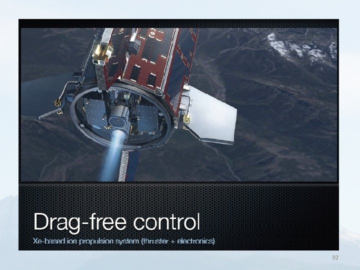
Solution introduced to present missions 2/3 • Accelerometer on board – Measures non-grav. forces. – Non-grav. forces can be compensated by drag-free control mechanism. – GOCE: drag-free Differential acceleration measurement: • non-grav accelerations drop out. • Rotational motion of satellite affects measurements

Solution introduced to present missions 3/3 • Gradient measurement – Counteract gravity field attenuation at altitude – Highlight small scale features (differentiation) GRACE: SST-ll (low-low SST tracking) GOCE: gradient measurement

GRACE satellite mission Gravity Recovery And Climate Experiment

GRACE satellite mission GRACE satellite: launch March 17, 2002. H=500 km Satellite separation: 200 km along track. Distance and rate changes measurement: Kband microwave ranging system. • Further: GPS receiver, Laser-retro-reflector, star-sensors, three-axis accelerometer • •

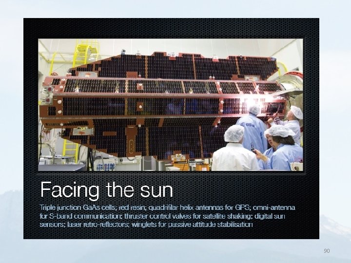
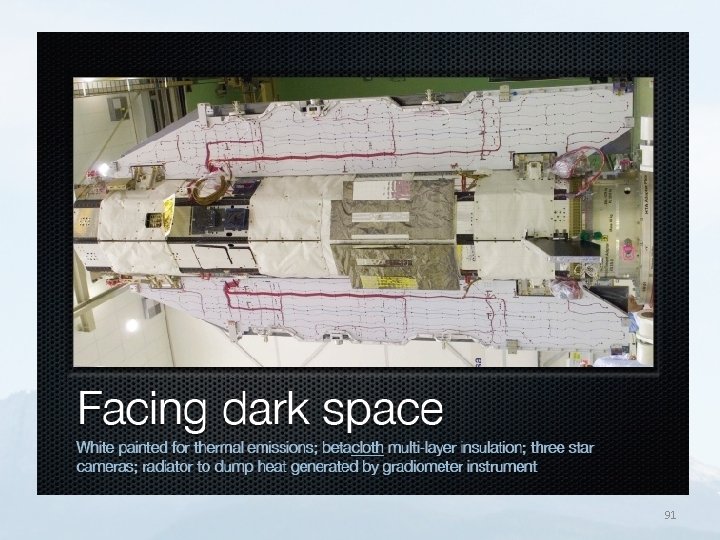
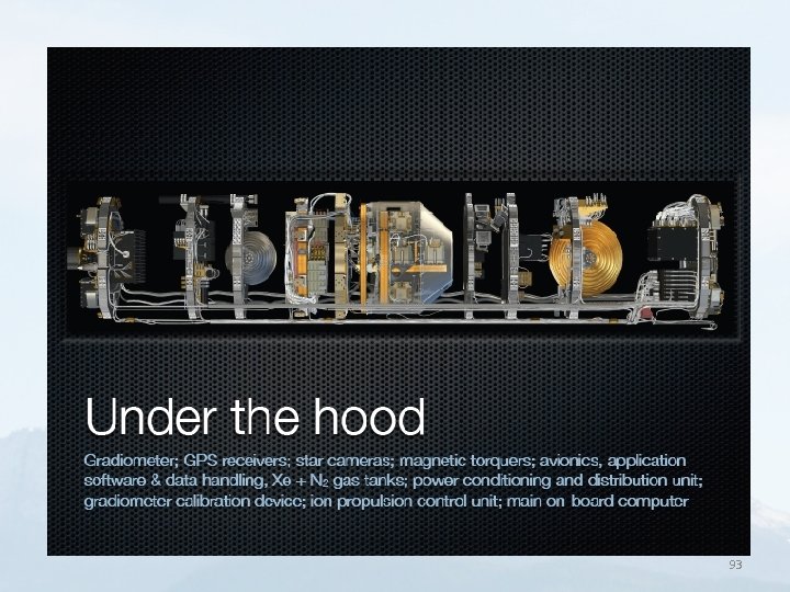
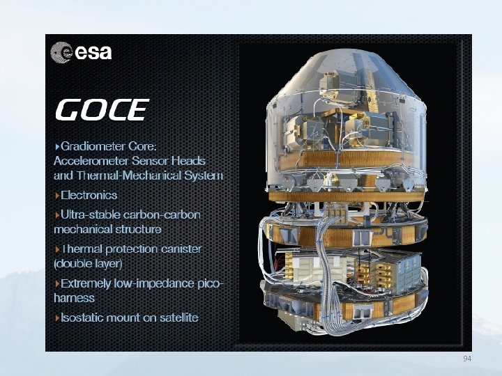
GOCE satellite mission Gravity-field and steady-state Ocean Circulation Experiment SST-hl: Satellite-Satellite Tracking in high-low mode. SGG: Satellite gravity gradiometry 83

GOCE characteristics • Goal: determine stationary gravity field • Accuracy 1 mgal, Geoid 1 -2 cm, 100 km resolution. In orbit: March 2009 to November 2013 • Low orbit (250 km), almost polar • Measurement: Gradiometer and position • Position: high-low satellites (GPS and GLONASS) and IGS terrestrial permanent stations • Error in position: cm-level in 3 D. 84

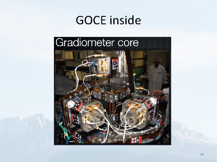
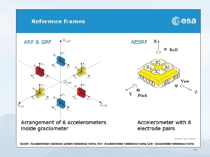
GOCE characteristics • Non-gravitational forces corrected from on-board accelerometer measurements • Satellite only field: up to degree and order n=280 (according to methodology and authors) • Gradiometer: – – 3 -axis. 6 capactivie accelerometers Gradient error: 1 Eötvös (E)= 10 -9 m/s 2/m=10 -7 Gal/m VZZ = vertical gradient on Earth = 3000 E 85

Scalar, vector, gradient tensor Li, 2010 86

Gravity gradient tensor • Gradient of full gravity vector:

Gradient tensor • Gradient tensor: analogous but more complicated modifications of the summation. • All tensor components can be reproduced globally, with the only knowledge of the table of Stokes-coefficients. 88

89

90

91

92

93

94

GOCE inside 95

96