Oceans and coastal processes Oceans cover approximately 72


- Slides: 65
Oceans and coastal processes
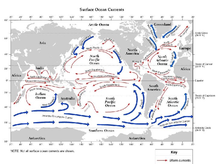
• Oceans cover approximately 72% of Earth • All the oceans are interconnected • Oceans help distribute heat
• 2 theories: • Comets hit Earth and released water • Outgassing from Volcanoes during earth’s early history
Volcanoes are the most accepted theory More than half of cloud is water vapor ---->
Approximately 4. 4 Billion years ago the Earth was cooled enough to sustain liquid water
Comets are dust and water
Sediments: • Weathering and erosion of land rocks eventually find their way to the oceans were they are deposited • Sediments may contain marine fossils • Sediments form sedimentary rocks
Why is the ocean salty? • Rivers and streams carry sediments and dissolved material (salts)into the ocean • Evaporation may cause salts to precipitate out.
Commercial salt beds
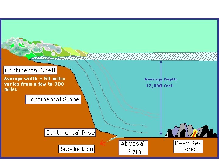
Ocean Floor Topograpgy • It includes basins, abyssal plains, and mid ridges.
Topography • Hydrosphere is thin – ave. depth ~ 4 km • Trenches can be VERY deep ~ 8 to 10 km deep • Mid-ocean ridges may rise above sea level ex. Iceland • Ocean shelf is shallow – good for fishing and oil drilling – but who owns them? • Abyssal plain low, flat ‘bowl’ like
topography
Mid Atlantic ridge • • Extends to 10, 000 miles. It is 25453 feet deep. Hits the surface and keeps going.
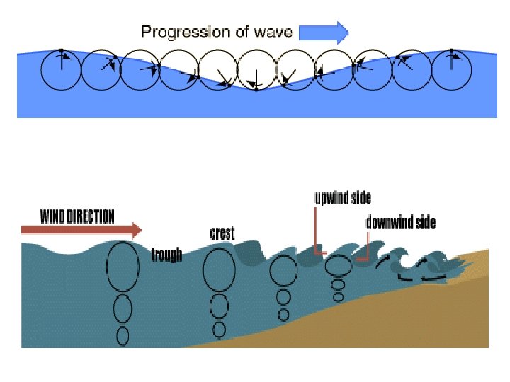
Waves and movement of water • In general waves move ENERGY not really water • Surface water moves in small ellipses as the wave (energy) passes by • Waves release energy as they break • Energy (waves) can move sediments along beach • Energy (waves) can shape shorelines
Waves form from the interaction of the atmosphere on the hydrosphere
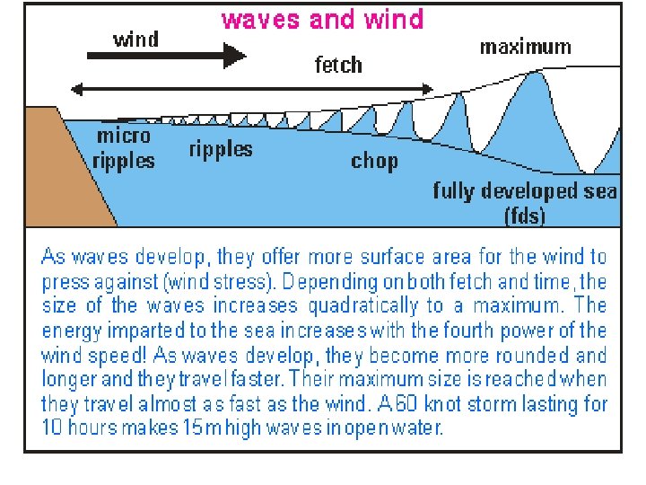
The longer the wind travels the bigger the waves get!
Storm surge erosion
North Caroline beach after a hurricane
Seiches • “to sway back and forth” • Caused by large change in air pressure and high winds • Winds blow for hours and cause water to ‘shift’ to one side of the basin
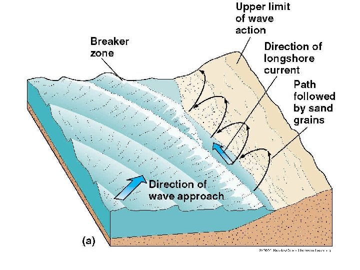
Longshore current
Longshore Currents • Caused by swells • Extends from shallow water • Change depending on size, shape, and direction of the swell
How do you determine the direction of the current? • • • Run parallel to shore From south to north From north to south From west to east From east to west
• • • the transportation of sediments direction depends on prevailing winds takes place in surf zone swash-movement of the pebble up the beach backwash-moves pebble back down beach
Jetties and longshore drift Be able to draw this!!
Rip currents or tides
How to escape a rip current! Swim across the current. • Keep in mind: NEVER SWIN BACK UP!!
Where They’re Formed • oceans
Spit- Sandspit – sand feature shaped by waves New Zealand Nelson West coast
Beach formations
Head land erosion
What is a headland? • Headlands are parts of a shore that reach out into the ocean • Coast are made up of different rock types: hard and soft rocks • Less resistant & more resistant rocks This is a stack.
Wave Action of the Headlands • Waves reach shallow water sooner at the headlands. • waves slow down sooner in front of headlands. • The wave bends nearly parallel to the headlands, and hits all three sides of the it.
Headland Erosion • Waves crash against headlands and form caves • Erosion continues and forms arches • Arches then break leaving a stack • Stacks break and form stumps
Refraction of Ocean Waves As a wave comes in, the end closest to shore scrapes bottom first and slows down.
Where does deposition occur? • Deposition occurs in the ocean right at the base the headlands. • Waves hit the base then cause abrasion • Coastlines are rounded All parts of a headland.
Sea Cliffs
Sea Stacks
Headland erosion
Head land
Wave erosion
South shore of Long Island showing shaping caused by waves.
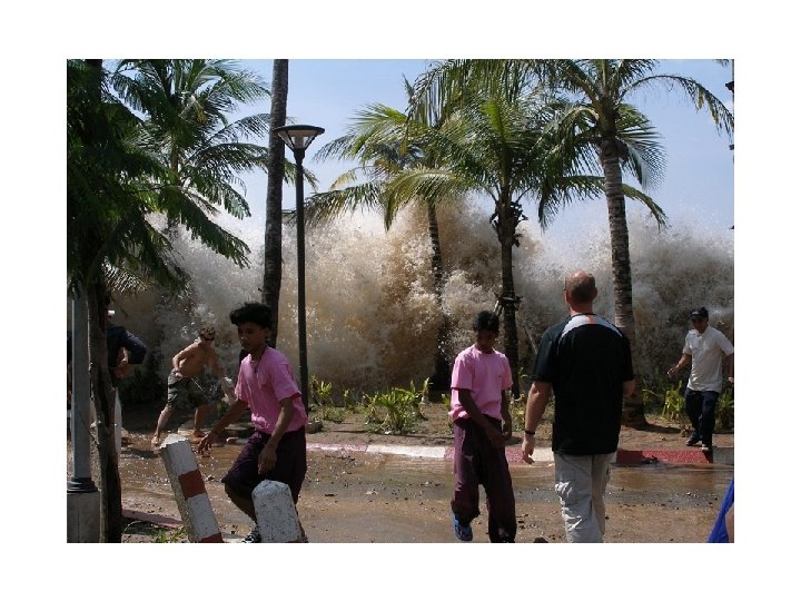
Tsunamis-Formed after earthquake HUGE waves, Much destruction
Tsunami formation
Tsunami formation
Preventing or reducing erosion:
Break walls
Walls
Groins • As sediments move down a beach because of the longshore current, the current loses velocity as it meets the groin. This causes the current to dump part of its sediment load on the upcurrent side of the groin. • As the current passes the groin it begins to pick-up sediment again, and erosion occurs on the beach located on the downcurrent side of the groin.
Groins
Groins • Groins are man-made structures used to change the effects of beach erosion.
groins
Unconsolidated glaical sediments -groins
More groins
Jetties
Jetties Packery Jetties channel to Gulf of Mexico