ECMWF Data Assimilation Training course Land Surface Data
- Slides: 42

ECMWF Data Assimilation Training course Land Surface Data Assimilation – Part 1 Patricia de Rosnay EUROPEAN CENTRE FOR MEDIUM-RANGE WEATHER FORECASTS © ECMWF

Outline Part I (Monday 7 March) • Introduction • Snow analysis • Screen level parameters analysis Part II (Tuesday 8 March) • Soil moisture analysis • Summary and future plans EUROPEAN CENTRE FOR MEDIUM-RANGE WEATHER FORECASTS © ECMWF

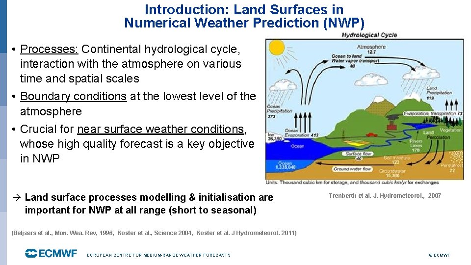
Introduction: Land Surfaces in Numerical Weather Prediction (NWP) • Processes: Continental hydrological cycle, interaction with the atmosphere on various time and spatial scales • Boundary conditions at the lowest level of the atmosphere • Crucial for near surface weather conditions, whose high quality forecast is a key objective in NWP Land surface processes modelling & initialisation are important for NWP at all range (short to seasonal) Trenberth et al. J. Hydrometeorol. , 2007 (Beljaars et al. , Mon. Wea. Rev, 1996, Koster et al. , Science 2004, Koster et al. J Hydrometeorol. 2011) EUROPEAN CENTRE FOR MEDIUM-RANGE WEATHER FORECASTS © ECMWF

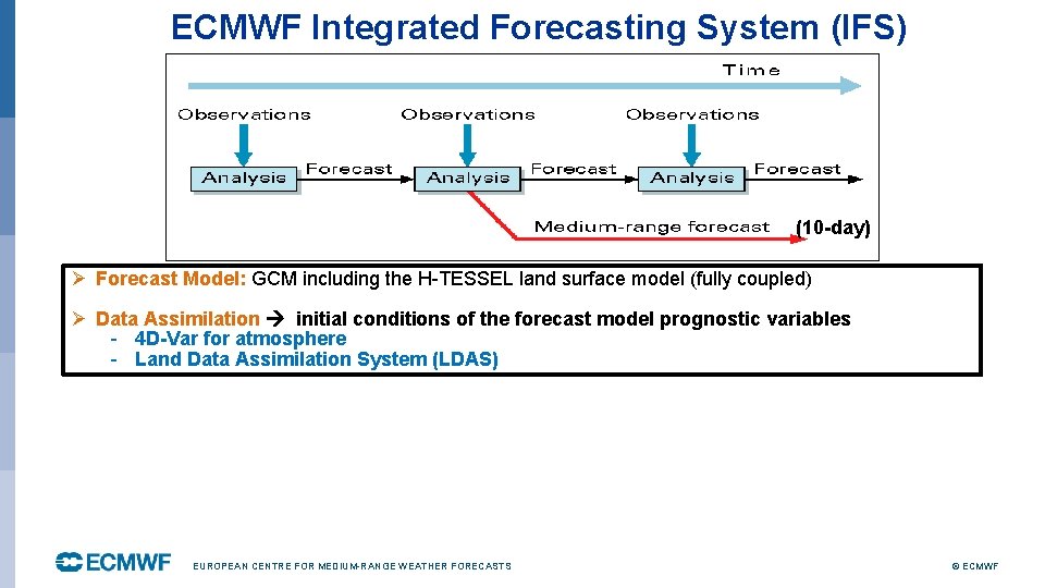
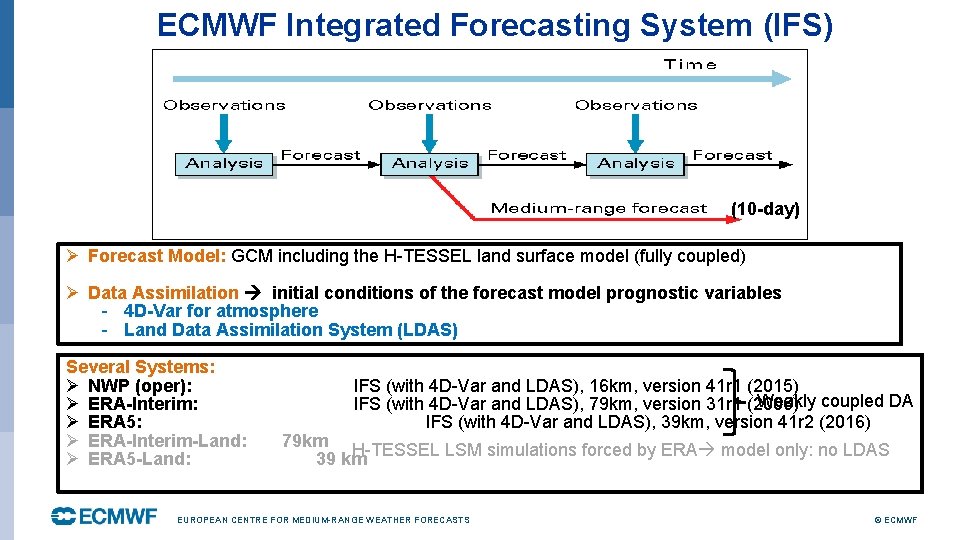
ECMWF Integrated Forecasting System (IFS) (10 -day) Ø Forecast Model: GCM including the H-TESSEL land surface model (fully coupled) Ø Data Assimilation initial conditions of the forecast model prognostic variables - 4 D-Var for atmosphere - Land Data Assimilation System (LDAS) EUROPEAN CENTRE FOR MEDIUM-RANGE WEATHER FORECASTS © ECMWF

ECMWF Integrated Forecasting System (IFS) (10 -day) Ø Forecast Model: GCM including the H-TESSEL land surface model (fully coupled) Ø Data Assimilation initial conditions of the forecast model prognostic variables - 4 D-Var for atmosphere - Land Data Assimilation System (LDAS) Several Systems: Ø NWP (oper): Ø ERA-Interim: Ø ERA 5: Ø ERA-Interim-Land: Ø ERA 5 -Land: IFS (with 4 D-Var and LDAS), 16 km, version 41 r 1 (2015) Weakly coupled DA IFS (with 4 D-Var and LDAS), 79 km, version 31 r 1 (2006) IFS (with 4 D-Var and LDAS), 39 km, version 41 r 2 (2016) 79 km H-TESSEL LSM simulations forced by ERA model only: no LDAS 39 km EUROPEAN CENTRE FOR MEDIUM-RANGE WEATHER FORECASTS © ECMWF

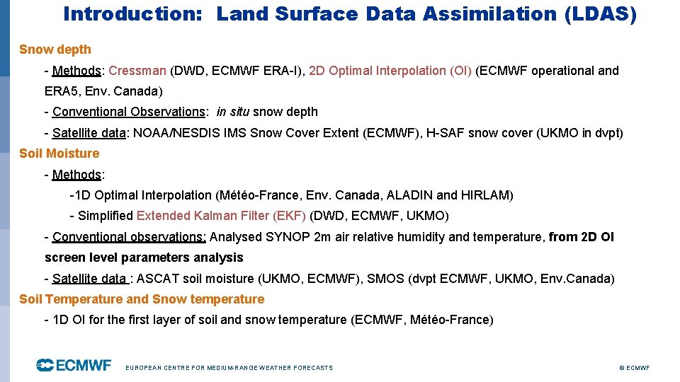
Introduction: Land Surface Data Assimilation (LDAS) Snow depth - Methods: Cressman (DWD, ECMWF ERA-I), 2 D Optimal Interpolation (OI) (ECMWF operational and ERA 5, Env. Canada) - Conventional Observations: in situ snow depth - Satellite data: NOAA/NESDIS IMS Snow Cover Extent (ECMWF), H-SAF snow cover (UKMO in dvpt) Soil Moisture - Methods: -1 D Optimal Interpolation (Météo-France, Env. Canada, ALADIN and HIRLAM) - Simplified Extended Kalman Filter (EKF) (DWD, ECMWF, UKMO) - Conventional observations: Analysed SYNOP 2 m air relative humidity and temperature, from 2 D OI screen level parameters analysis - Satellite data : ASCAT soil moisture (UKMO, ECMWF), SMOS (dvpt ECMWF, UKMO, Env. Canada) Soil Temperature and Snow temperature - 1 D OI for the first layer of soil and snow temperature (ECMWF, Météo-France) EUROPEAN CENTRE FOR MEDIUM-RANGE WEATHER FORECASTS © ECMWF

Outline Part I (Monday 7 March) • Introduction • Snow analysis • Screen level parameters analysis Part II (Tuesday 8 March) • Soil moisture analysis • Summary and future plans EUROPEAN CENTRE FOR MEDIUM-RANGE WEATHER FORECASTS © ECMWF

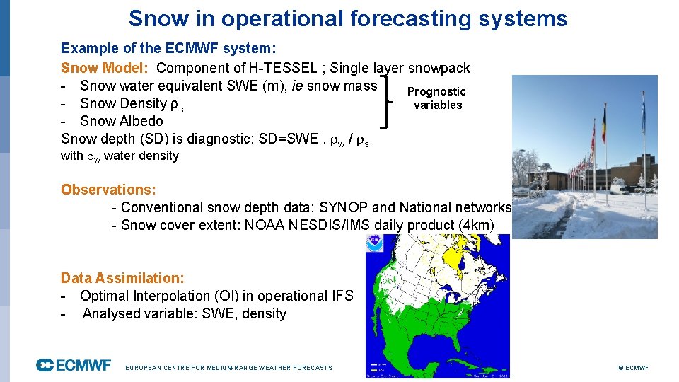
Snow in operational forecasting systems Example of the ECMWF system: Snow Model: Component of H-TESSEL ; Single layer snowpack - Snow water equivalent SWE (m), ie snow mass Prognostic - Snow Density ρs variables - Snow Albedo Snow depth (SD) is diagnostic: SD=SWE. w / s with w water density Observations: - Conventional snow depth data: SYNOP and National networks - Snow cover extent: NOAA NESDIS/IMS daily product (4 km) Data Assimilation: - Optimal Interpolation (OI) in operational IFS - Analysed variable: SWE, density EUROPEAN CENTRE FOR MEDIUM-RANGE WEATHER FORECASTS © ECMWF

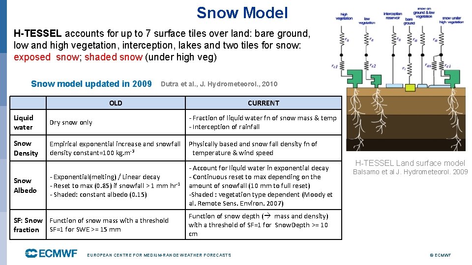
Snow Model H-TESSEL accounts for up to 7 surface tiles over land: bare ground, low and high vegetation, interception, lakes and two tiles for snow: exposed snow; shaded snow (under high veg) Snow model updated in 2009 Dutra et al. , J. Hydrometeorol. , 2010 OLD CURRENT Liquid water Dry snow only - Fraction of liquid water fn of snow mass & temp - Interception of rainfall Snow Density Empirical exponential increase and snowfall density constant=100 kg. m-3 Physically based and snow fall density fn of temperature & wind speed - Exponential(melting) / Linear decay - Reset to max (0. 85) if snowfall > 1 mm hr-1 - Shaded: constant albedo (0. 15) - Account for liquid water in exponential decay - Continuous reset to max depending on the amount of snowfall (10 mm to full reset) -Shaded : vegetation type dependent (Moody et al. Remote Sens. Environ. 2007) Snow Albedo SF: Snow Function of snow mass with a threshold fraction SF=1 for SWE >= 15 mm H-TESSEL Land surface model Balsamo et al J. Hydrometeorol. 2009 Function of snow depth ( mass and density) with a threshold of SF=1 for Snow. Depth >= 10 cm EUROPEAN CENTRE FOR MEDIUM-RANGE WEATHER FORECASTS © ECMWF

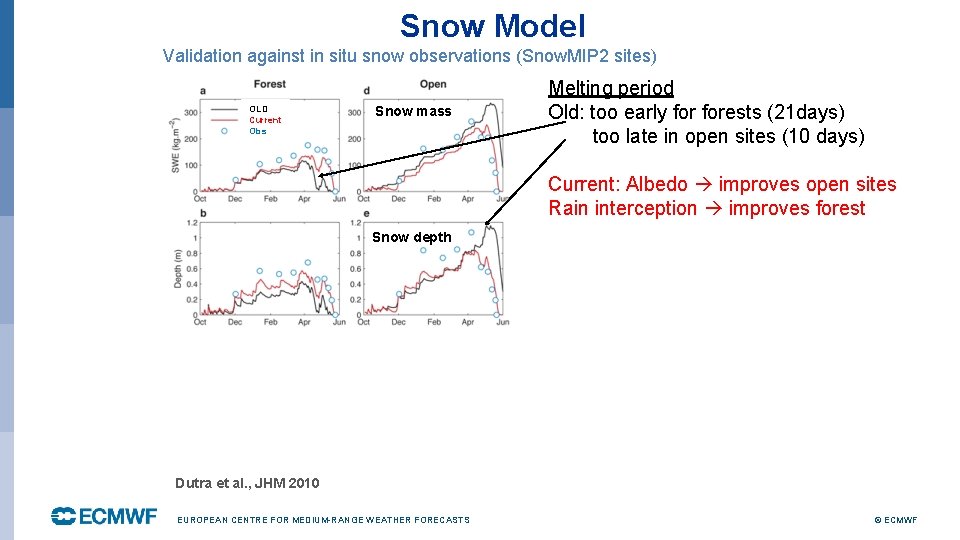
Snow Model Validation against in situ snow observations (Snow. MIP 2 sites) OLD Current Obs Snow mass Melting period Old: too early forests (21 days) too late in open sites (10 days) Current: Albedo improves open sites Rain interception improves forest Snow depth Dutra et al. , JHM 2010 EUROPEAN CENTRE FOR MEDIUM-RANGE WEATHER FORECASTS © ECMWF

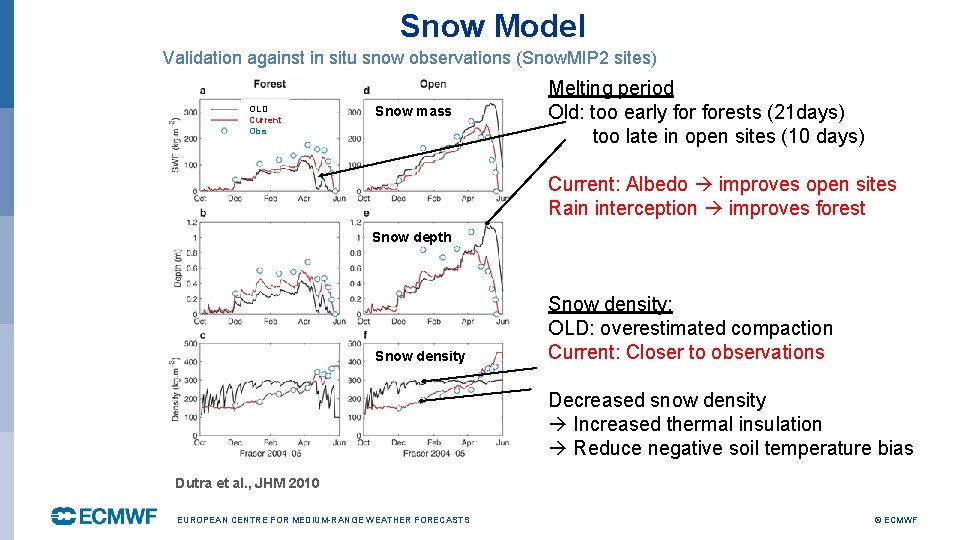
Snow Model Validation against in situ snow observations (Snow. MIP 2 sites) OLD Current Obs Snow mass Melting period Old: too early forests (21 days) too late in open sites (10 days) Current: Albedo improves open sites Rain interception improves forest Snow depth Snow density: OLD: overestimated compaction Current: Closer to observations Decreased snow density Increased thermal insulation Reduce negative soil temperature bias Dutra et al. , JHM 2010 EUROPEAN CENTRE FOR MEDIUM-RANGE WEATHER FORECASTS © ECMWF

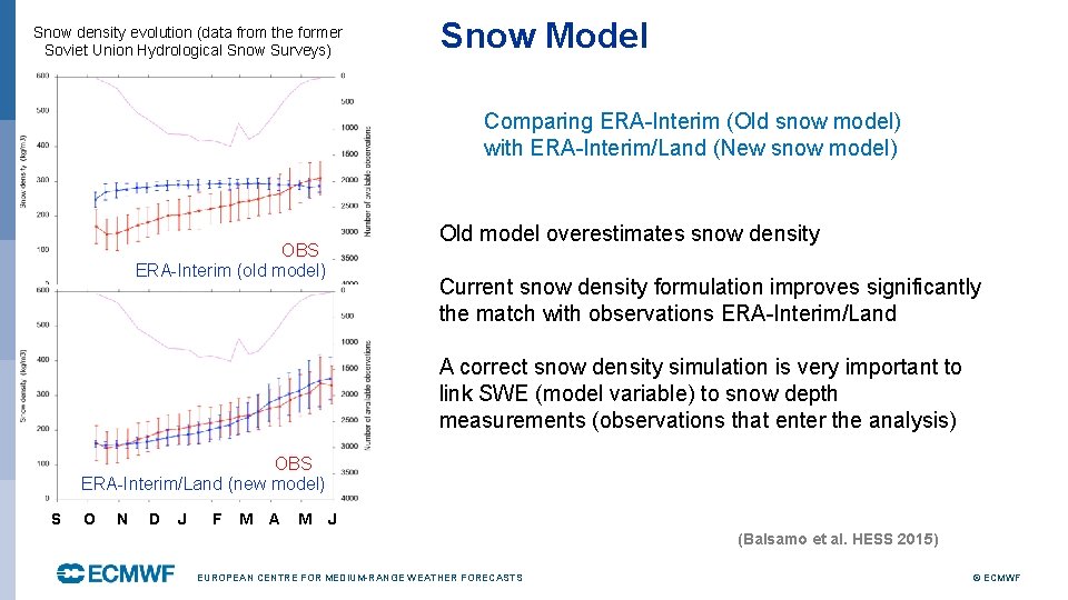
Snow density evolution (data from the former Soviet Union Hydrological Snow Surveys) Snow Model Comparing ERA-Interim (Old snow model) with ERA-Interim/Land (New snow model) Old model overestimates snow density OBS ERA-Interim (old model) Current snow density formulation improves significantly the match with observations ERA-Interim/Land A correct snow density simulation is very important to link SWE (model variable) to snow depth measurements (observations that enter the analysis) OBS ERA-Interim/Land (new model) S O N D J F M A M J (Balsamo et al. HESS 2015) EUROPEAN CENTRE FOR MEDIUM-RANGE WEATHER FORECASTS © ECMWF

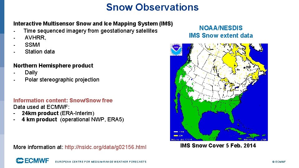
Snow Observations Interactive Multisensor Snow and Ice Mapping System (IMS) - Time sequenced imagery from geostationary satellites AVHRR, SSM/I Station data NOAA/NESDIS IMS Snow extent data Northern Hemisphere product Daily Polar stereographic projection Information content: Snow/Snow free Data used at ECMWF: - 24 km product (ERA-Interim) - 4 km product (operational NWP, ERA 5) More information at: http: //nsidc. org/data/g 02156. html EUROPEAN CENTRE FOR MEDIUM-RANGE WEATHER FORECASTS IMS Snow Cover 5 Feb. 2014 © ECMWF

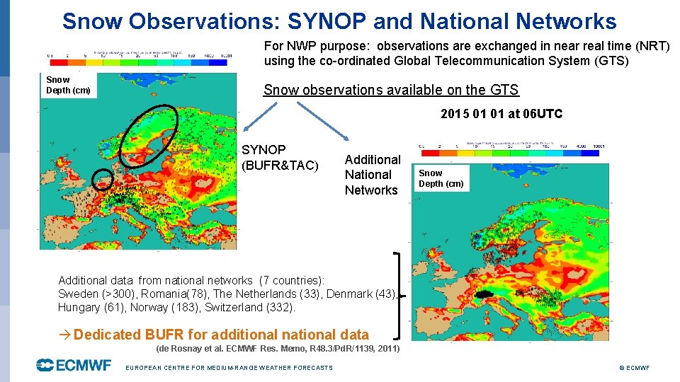
Snow Observations: SYNOP and National Networks For NWP purpose: observations are exchanged in near real time (NRT) using the co-ordinated Global Telecommunication System (GTS) Snow Depth (cm) Snow observations available on the GTS 2015 01 01 at 06 UTC SYNOP (BUFR&TAC) Additional National Networks Snow Depth (cm) Additional data from national networks (7 countries): Sweden (>300), Romania(78), The Netherlands (33), Denmark (43), Hungary (61), Norway (183), Switzerland (332). Dedicated BUFR for additional national data (de Rosnay et al. ECMWF Res. Memo, R 48. 3/Pd. R/1139, 2011) EUROPEAN CENTRE FOR MEDIUM-RANGE WEATHER FORECASTS © ECMWF

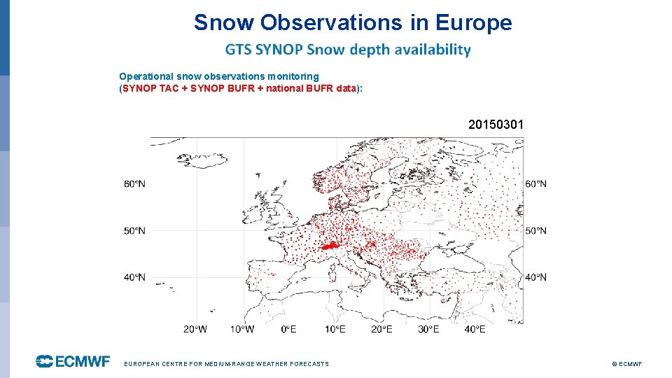
Snow Observations in Europe Operational snow observations monitoring (SYNOP TAC + SYNOP BUFR + national BUFR data): 20150301 EUROPEAN CENTRE FOR MEDIUM-RANGE WEATHER FORECASTS © ECMWF

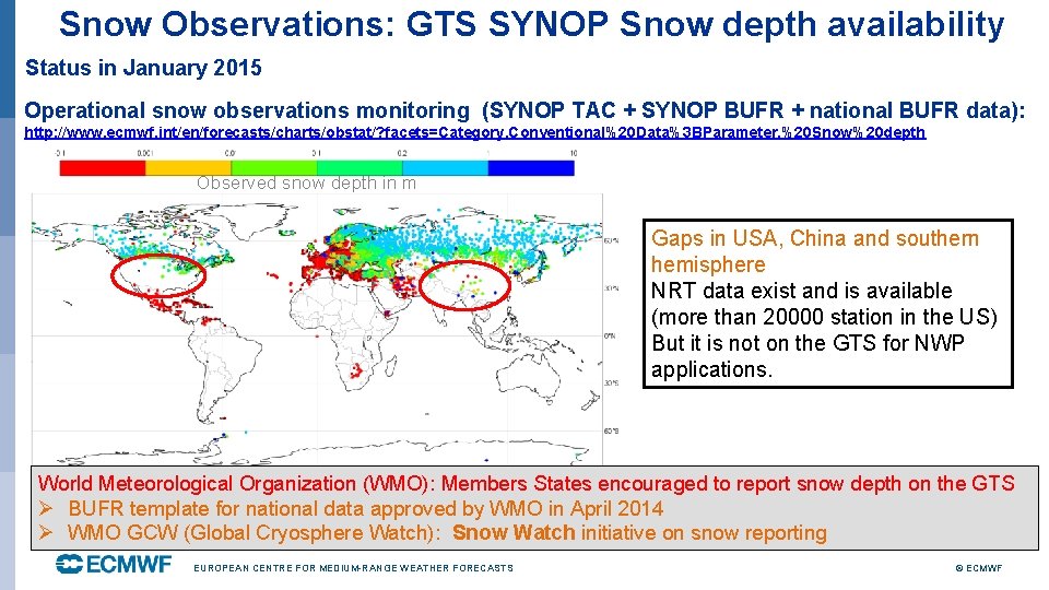
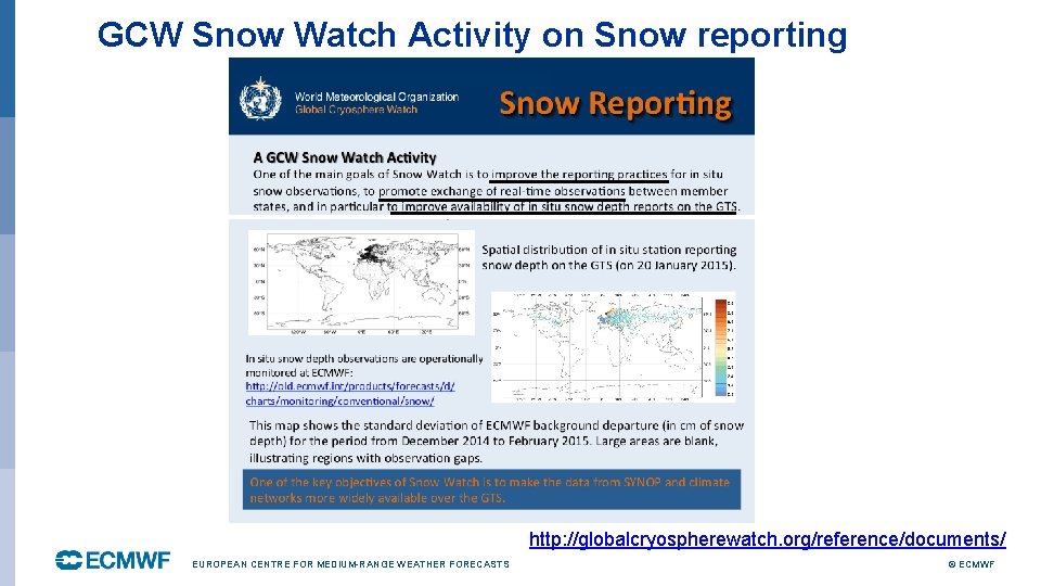
Snow Observations: GTS SYNOP Snow depth availability Status in January 2015 Operational snow observations monitoring (SYNOP TAC + SYNOP BUFR + national BUFR data): http: //www. ecmwf. int/en/forecasts/charts/obstat/? facets=Category, Conventional%20 Data%3 BParameter, %20 Snow%20 depth Observed snow depth in m Gaps in USA, China and southern hemisphere NRT data exist and is available (more than 20000 station in the US) But it is not on the GTS for NWP applications. World Meteorological Organization (WMO): Members States encouraged to report snow depth on the GTS Ø BUFR template for national data approved by WMO in April 2014 Ø WMO GCW (Global Cryosphere Watch): Snow Watch initiative on snow reporting EUROPEAN CENTRE FOR MEDIUM-RANGE WEATHER FORECASTS © ECMWF

GCW Snow Watch Activity on Snow reporting http: //globalcryospherewatch. org/reference/documents/ EUROPEAN CENTRE FOR MEDIUM-RANGE WEATHER FORECASTS © ECMWF

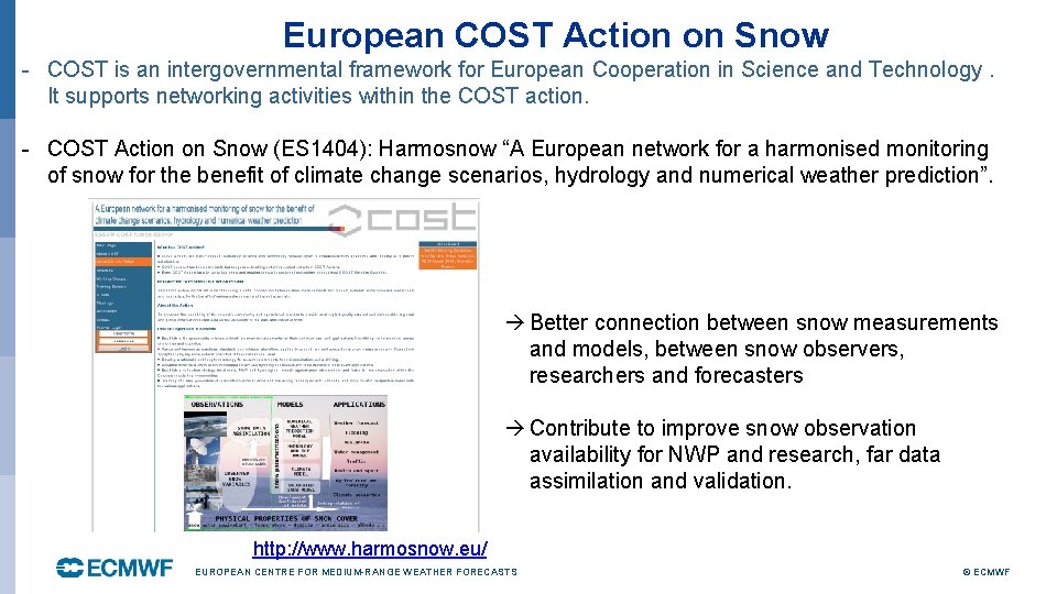
European COST Action on Snow - COST is an intergovernmental framework for European Cooperation in Science and Technology. It supports networking activities within the COST action. - COST Action on Snow (ES 1404): Harmosnow “A European network for a harmonised monitoring of snow for the benefit of climate change scenarios, hydrology and numerical weather prediction”. Better connection between snow measurements and models, between snow observers, researchers and forecasters Contribute to improve snow observation availability for NWP and research, far data assimilation and validation. http: //www. harmosnow. eu/ EUROPEAN CENTRE FOR MEDIUM-RANGE WEATHER FORECASTS © ECMWF

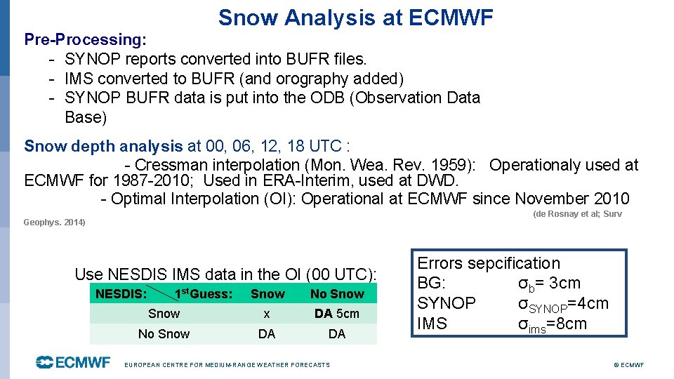
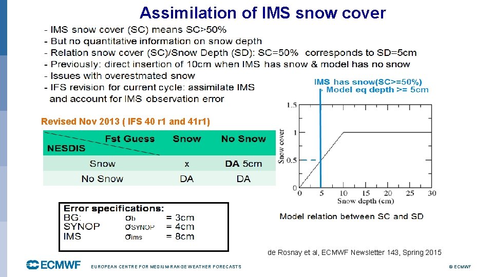
Snow Analysis at ECMWF Pre-Processing: - SYNOP reports converted into BUFR files. - IMS converted to BUFR (and orography added) - SYNOP BUFR data is put into the ODB (Observation Data Base) Snow depth analysis at 00, 06, 12, 18 UTC : - Cressman interpolation (Mon. Wea. Rev. 1959): Operationaly used at ECMWF for 1987 -2010; Used in ERA-Interim, used at DWD. - Optimal Interpolation (OI): Operational at ECMWF since November 2010 (de Rosnay et al; Surv Geophys. 2014) Use NESDIS IMS data in the OI (00 UTC): NESDIS: 1 st. Guess: Snow No Snow x DA 5 cm No Snow DA DA EUROPEAN CENTRE FOR MEDIUM-RANGE WEATHER FORECASTS Errors sepcification BG: σb= 3 cm SYNOP σSYNOP=4 cm IMS σims=8 cm © ECMWF

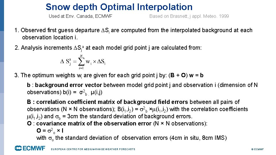
Snow depth Optimal Interpolation Used at Env. Canada, ECMWF Based on Brasnett, j appl. Meteo. 1999 1. Observed first guess departure Si are computed from the interpolated background at each observation location i. 2. Analysis increments Sja at each model grid point j are calculated from: 3. The optimum weights wi are given for each grid point j by: (B + O) w = b b : background error vector between model grid point j and observation i (dimension of N observations) b(i) = σ2 b. μ(i, j) B : correlation coefficient matrix of background field errors between all pairs of observations (N × N observations); B(i 1, i 2) = 2 b × (i 1, i 2) with the correlation coefficients (i 1, i 2) and b = 3 cm the standard deviation of background errors. O : covariance matrix of the observation error (N × N observations): O = 2 o × I with o the standard deviation of observation errors (4 cm in situ, 8 cm IMS) EUROPEAN CENTRE FOR MEDIUM-RANGE WEATHER FORECASTS © ECMWF

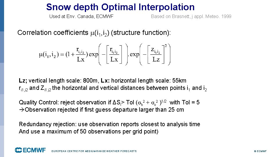
Snow depth Optimal Interpolation Used at Env. Canada, ECMWF Based on Brasnett, j appl. Meteo. 1999 Correlation coefficients (i 1, i 2) (structure function): Lz; vertical length scale: 800 m, Lx: horizontal length scale: 55 km ri 1, i 2 and Zi 1, i 2 the horizontal and vertical distances between points i 1 and i 2 Quality Control: reject observation if ΔSi> Tol (σb 2 + σo 2 )1/2 with Tol = 5 Observation rejected if first guess departure larger than 25 cm Redundancy rejection: use observation reports closest to analysis time And use a maximum of 50 observations per grid point) EUROPEAN CENTRE FOR MEDIUM-RANGE WEATHER FORECASTS © ECMWF

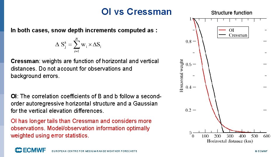
OI vs Cressman Structure function In both cases, snow depth increments computed as : Cressman: weights are function of horizontal and vertical distances. Do not account for observations and background errors. OI: The correlation coefficients of B and b follow a secondorder autoregressive horizontal structure and a Gaussian for the vertical elevation differences. OI has longer tails than Cressman and considers more observations. Model/observation information optimally weighted using error statistics. EUROPEAN CENTRE FOR MEDIUM-RANGE WEATHER FORECASTS © ECMWF

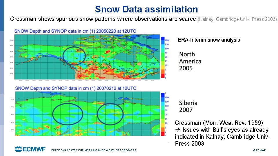
Snow Data assimilation Cressman shows spurious snow patterns where observations are scarce (Kalnay, Cambridge Univ. Press 2003) ERA-Interim snow analysis Cressman (Mon. Wea. Rev. 1959) Issues with Bull’s eyes as already indicated in Kalnay, Cambridge Univ. Press 2003 EUROPEAN CENTRE FOR MEDIUM-RANGE WEATHER FORECASTS © ECMWF

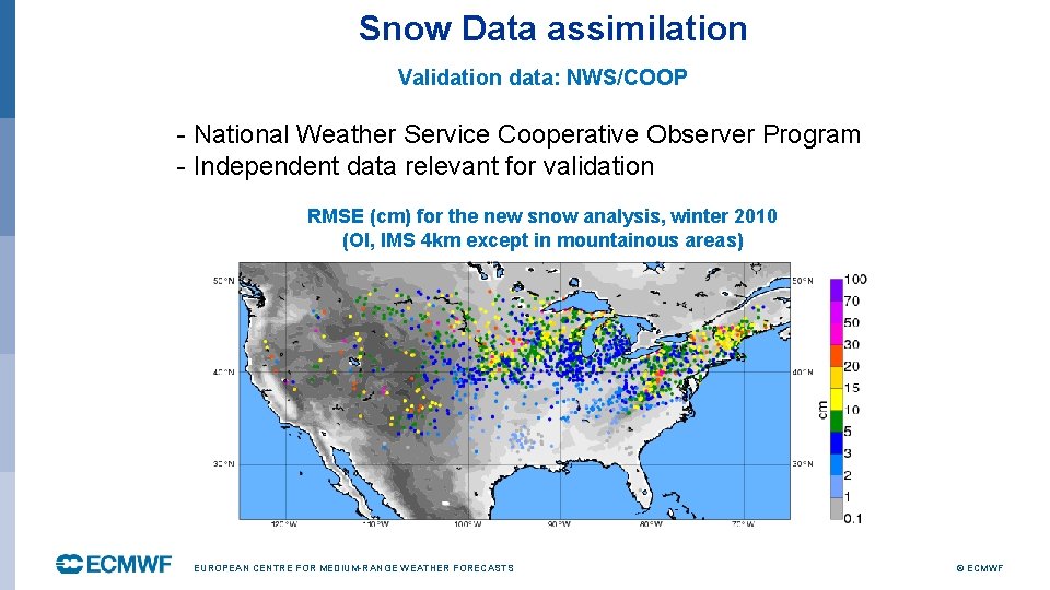
Snow Data assimilation Validation data: NWS/COOP - National Weather Service Cooperative Observer Program - Independent data relevant for validation RMSE (cm) for the new snow analysis, winter 2010 (OI, IMS 4 km except in mountainous areas) EUROPEAN CENTRE FOR MEDIUM-RANGE WEATHER FORECASTS © ECMWF

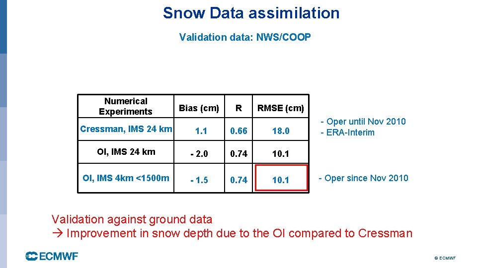
Snow Data assimilation Validation data: NWS/COOP Numerical Experiments Bias (cm) R RMSE (cm) Cressman, IMS 24 km 1. 1 0. 66 18. 0 OI, IMS 24 km - 2. 0 0. 74 10. 1 OI, IMS 4 km <1500 m - 1. 5 0. 74 10. 1 - Oper until Nov 2010 - ERA-Interim - Oper since Nov 2010 Validation against ground data Improvement in snow depth due to the OI compared to Cressman © ECMWF

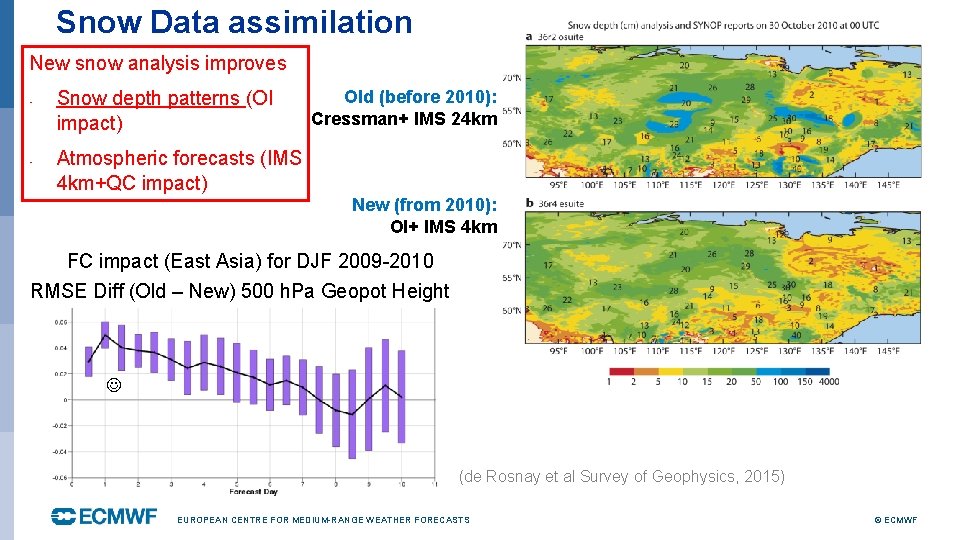
Snow Data assimilation Cressman +24 km NESDIS New snow analysis improves - - Snow depth patterns (OI impact) Old (before 2010): Cressman+ IMS 24 km Atmospheric forecasts (IMS 4 km+QC impact) New (from 2010): OI+ IMS 4 km OI Brasnett 1999 +4 km NESDIS FC impact (East Asia) for DJF 2009 -2010 RMSE Diff (Old – New) 500 h. Pa Geopot Height (de Rosnay et al Survey of Geophysics, 2015) EUROPEAN CENTRE FOR MEDIUM-RANGE WEATHER FORECASTS © ECMWF

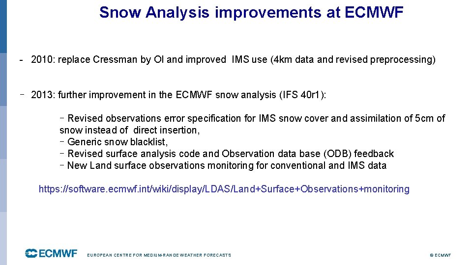
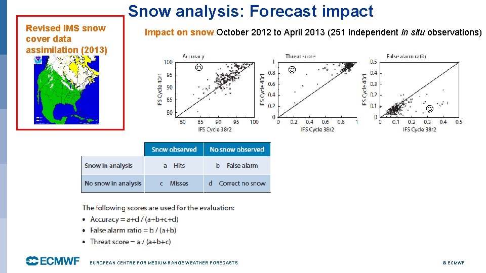
Snow Analysis improvements at ECMWF - 2010: replace Cressman by OI and improved IMS use (4 km data and revised preprocessing) - 2013: further improvement in the ECMWF snow analysis (IFS 40 r 1): - Revised observations error specification for IMS snow cover and assimilation of 5 cm of snow instead of direct insertion, - Generic snow blacklist, - Revised surface analysis code and Observation data base (ODB) feedback - New Land surface observations monitoring for conventional and IMS data https: //software. ecmwf. int/wiki/display/LDAS/Land+Surface+Observations+monitoring EUROPEAN CENTRE FOR MEDIUM-RANGE WEATHER FORECASTS © ECMWF

Assimilation of IMS snow cover Revised Nov 2013 ( IFS 40 r 1 and 41 r 1) de Rosnay et al, ECMWF Newsletter 143, Spring 2015 EUROPEAN CENTRE FOR MEDIUM-RANGE WEATHER FORECASTS © ECMWF

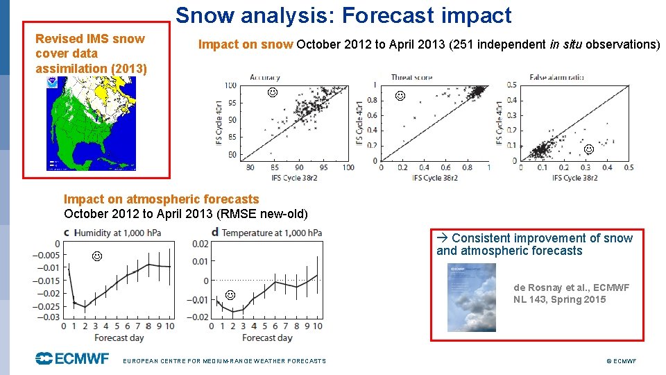
Snow analysis: Forecast impact Revised IMS snow cover data assimilation (2013) Impact on snow October 2012 to April 2013 (251 independent in situ observations) EUROPEAN CENTRE FOR MEDIUM-RANGE WEATHER FORECASTS © ECMWF

Snow analysis: Forecast impact Revised IMS snow cover data assimilation (2013) Impact on snow October 2012 to April 2013 (251 independent in situ observations) Impact on atmospheric forecasts October 2012 to April 2013 (RMSE new-old) Consistent improvement of snow and atmospheric forecasts EUROPEAN CENTRE FOR MEDIUM-RANGE WEATHER FORECASTS de Rosnay et al. , ECMWF NL 143, Spring 2015 © ECMWF

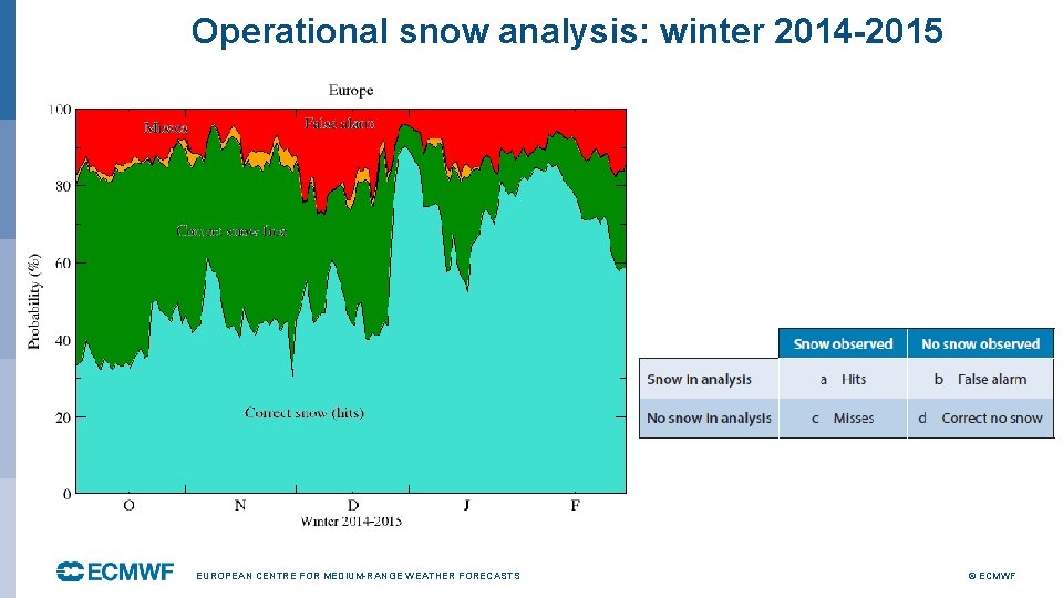
Operational snow analysis: winter 2014 -2015 EUROPEAN CENTRE FOR MEDIUM-RANGE WEATHER FORECASTS © ECMWF

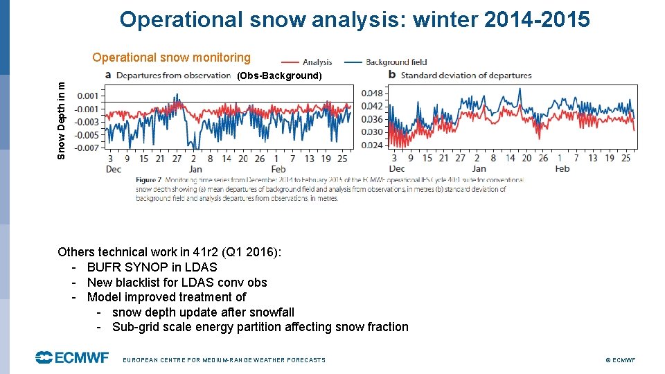
Operational snow analysis: winter 2014 -2015 Operational snow monitoring Snow Depth in m (Obs-Background) Others technical work in 41 r 2 (Q 1 2016): - BUFR SYNOP in LDAS - New blacklist for LDAS conv obs - Model improved treatment of - snow depth update after snowfall - Sub-grid scale energy partition affecting snow fraction EUROPEAN CENTRE FOR MEDIUM-RANGE WEATHER FORECASTS © ECMWF

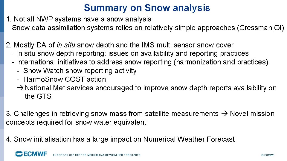
Summary on Snow analysis 1. Not all NWP systems have a snow analysis Snow data assimilation systems relies on relatively simple approaches (Cressman, OI) 2. Mostly DA of in situ snow depth and the IMS multi sensor snow cover - In situ snow depth reporting: issues on availability and reporting practices - International initiatives to address snow reporting (harmonization and practices): - Snow Watch snow reporting activity - Harmo. Snow COST action National Met services encouraged to improve snow depth reports availability on the GTS 3. Challenges in retrieving snow mass from satellite measurements Novel mission concepts required for snow water equivalent 4. Snow initialisation has a large impact on Numerical Weather Forecast EUROPEAN CENTRE FOR MEDIUM-RANGE WEATHER FORECASTS © ECMWF

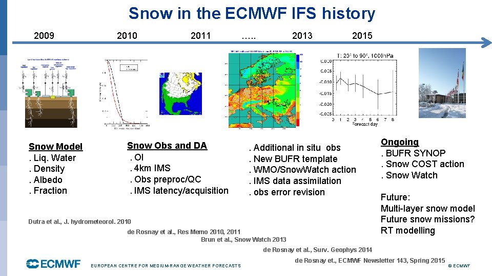
Snow in the ECMWF IFS history 2009 Snow Model. Liq. Water. Density. Albedo. Fraction 2010 2011 Snow Obs and DA. OI. 4 km IMS. Obs preproc/QC. IMS latency/acquisition …. . 2013 2015 . Additional in situ obs. New BUFR template. WMO/Snow. Watch action. IMS data assimilation. obs error revision Dutra et al. , J. hydrometeorol. 2010 de Rosnay et al. , Res Memo 2010, 2011 Brun et al. , Snow Watch 2013 Ongoing. BUFR SYNOP. Snow COST action. Snow Watch Future: Multi-layer snow model Future snow missions? RT modelling de Rosnay et al. , Surv. Geophys 2014 EUROPEAN CENTRE FOR MEDIUM-RANGE WEATHER FORECASTS de Rosnay et. , ECMWF Newsletter 143, Spring 2015 © ECMWF

Outline Part I (Monday) • Introduction • Snow analysis • Screen level parameters analysis Part II (Tuesday) • Soil moisture analysis • Summary and future plans EUROPEAN CENTRE FOR MEDIUM-RANGE WEATHER FORECASTS © ECMWF

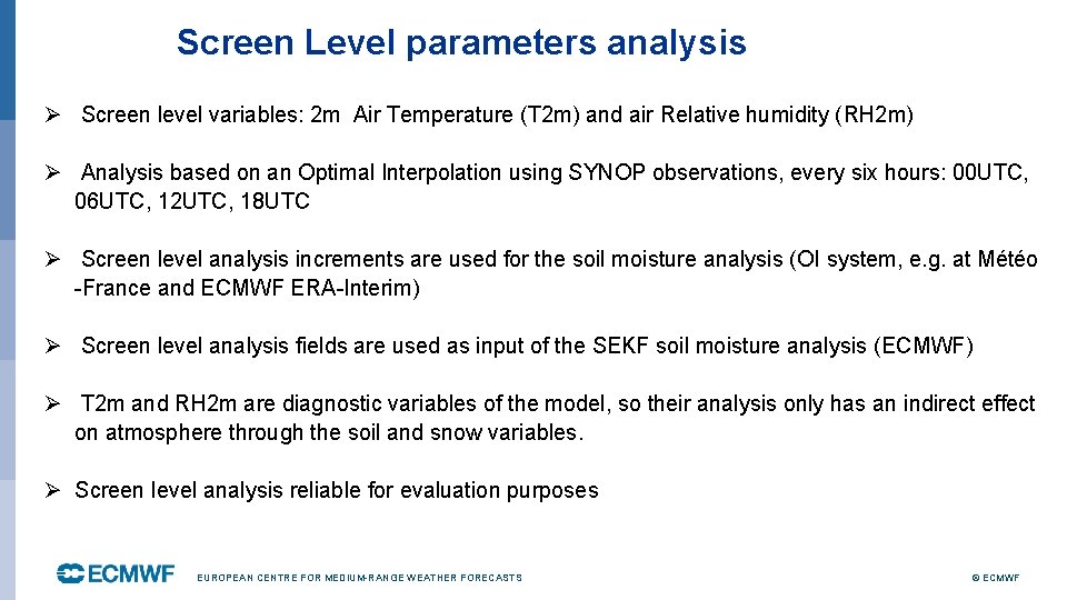
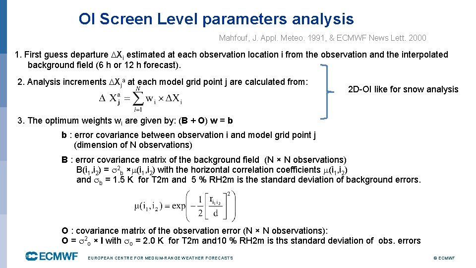
Screen Level parameters analysis Ø Screen level variables: 2 m Air Temperature (T 2 m) and air Relative humidity (RH 2 m) Ø Analysis based on an Optimal Interpolation using SYNOP observations, every six hours: 00 UTC, 06 UTC, 12 UTC, 18 UTC Ø Screen level analysis increments are used for the soil moisture analysis (OI system, e. g. at Météo -France and ECMWF ERA-Interim) Ø Screen level analysis fields are used as input of the SEKF soil moisture analysis (ECMWF) Ø T 2 m and RH 2 m are diagnostic variables of the model, so their analysis only has an indirect effect on atmosphere through the soil and snow variables. Ø Screen level analysis reliable for evaluation purposes EUROPEAN CENTRE FOR MEDIUM-RANGE WEATHER FORECASTS © ECMWF

OI Screen Level parameters analysis Mahfouf, J. Appl. Meteo. 1991, & ECMWF News Lett. 2000 1. First guess departure Xi estimated at each observation location i from the observation and the interpolated background field (6 h or 12 h forecast). 2. Analysis increments Xja at each model grid point j are calculated from: 2 D-OI like for snow analysis 3. The optimum weights wi are given by: (B + O) w = b b : error covariance between observation i and model grid point j (dimension of N observations) B : error covariance matrix of the background field (N × N observations) B(i 1, i 2) = 2 b × (i 1, i 2) with the horizontal correlation coefficients (i 1, i 2) and b = 1. 5 K for T 2 m and 5 % RH 2 m is the standard deviation of background errors. O : covariance matrix of the observation error (N × N observations): O = 2 o × I with o = 2. 0 K for T 2 m and 10 % RH 2 m is ths standard deviation of obs. errors EUROPEAN CENTRE FOR MEDIUM-RANGE WEATHER FORECASTS © ECMWF

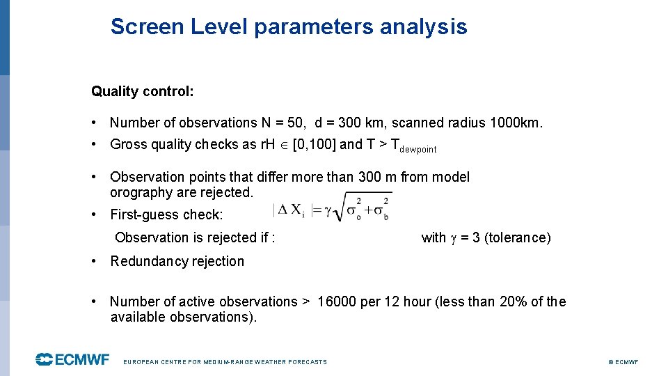
Screen Level parameters analysis Quality control: • Number of observations N = 50, d = 300 km, scanned radius 1000 km. • Gross quality checks as r. H [0, 100] and T > Tdewpoint • Observation points that differ more than 300 m from model orography are rejected. • First-guess check: Observation is rejected if : with = 3 (tolerance) • Redundancy rejection • Number of active observations > 16000 per 12 hour (less than 20% of the available observations). EUROPEAN CENTRE FOR MEDIUM-RANGE WEATHER FORECASTS © ECMWF

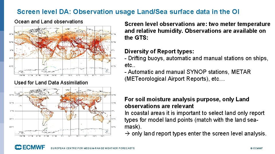
Screen level DA: Observation usage Land/Sea surface data in the OI Ocean and Land observations Used for Land Data Assimilation Screen level observations are: two meter temperature and relative humidity. Observations are available on the GTS: Diversity of Report types: - Drifting buoys, automatic and manual stations on ships, etc. . - Automatic and manual SYNOP stations, METAR (METeorological Airport Reports), etc… For soil moisture analysis purpose, only Land observations are relevant In coastal areas it is important to select land only report types for model land points (match with the land seamask). only land report types enter the screen level analysis. EUROPEAN CENTRE FOR MEDIUM-RANGE WEATHER FORECASTS © ECMWF

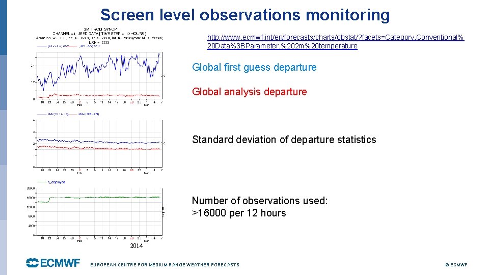
Screen level observations monitoring http: //www. ecmwf. int/en/forecasts/charts/obstat/? facets=Category, Conventional% 20 Data%3 BParameter, %202 m%20 temperature Global first guess departure Global analysis departure Standard deviation of departure statistics Number of observations used: >16000 per 12 hours 2014 EUROPEAN CENTRE FOR MEDIUM-RANGE WEATHER FORECASTS © ECMWF

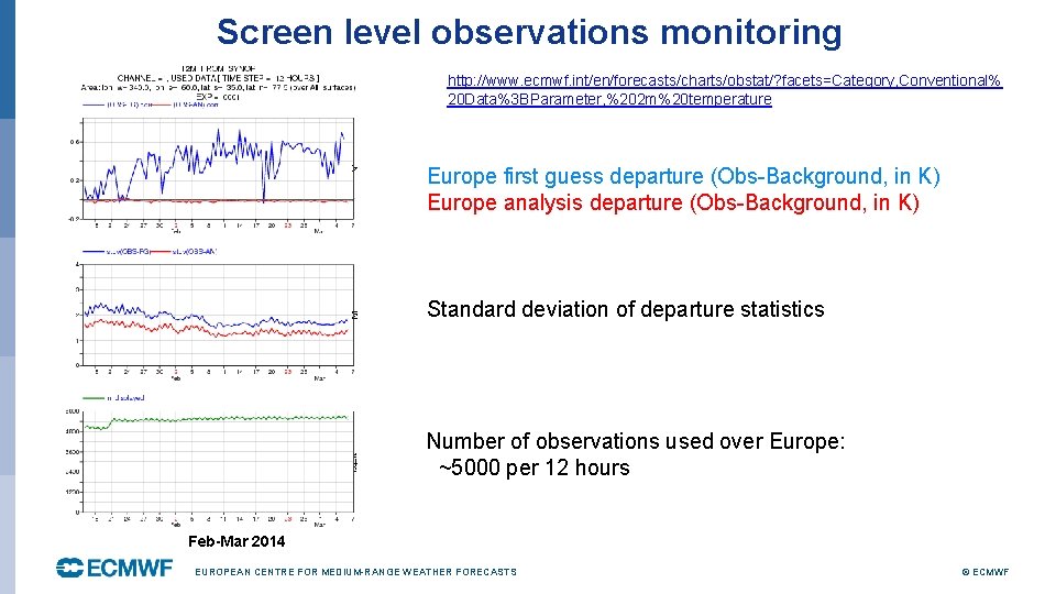
Screen level observations monitoring http: //www. ecmwf. int/en/forecasts/charts/obstat/? facets=Category, Conventional% 20 Data%3 BParameter, %202 m%20 temperature Europe first guess departure (Obs-Background, in K) Europe analysis departure (Obs-Background, in K) Standard deviation of departure statistics Number of observations used over Europe: ~5000 per 12 hours Feb-Mar 2014 EUROPEAN CENTRE FOR MEDIUM-RANGE WEATHER FORECASTS © ECMWF

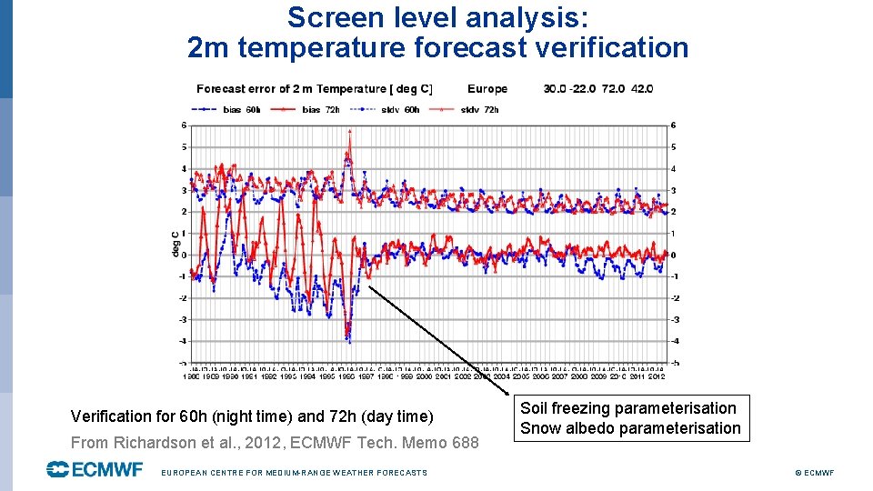
Screen level analysis: 2 m temperature forecast verification tm 578. pdf Verification for 60 h (night time) and 72 h (day time) From Richardson et al. , 2012, ECMWF Tech. Memo 688 EUROPEAN CENTRE FOR MEDIUM-RANGE WEATHER FORECASTS Soil freezing parameterisation Snow albedo parameterisation © ECMWF