
ECMWF long range forecast systems Dr Tim Stockdale




- Slides: 32
ECMWF long range forecast systems Dr. Tim Stockdale European Centre for Medium-Range Weather Forecasts © ECMWF FOCRAII-9, Beijing 10 th April 2013
Outline l Overview of System 4 l Some recent research results l EUROSIP multi-model forecasts l Forecasts for JJA 2013 © ECMWF FOCRAII-9, Beijing 10 th April 2013
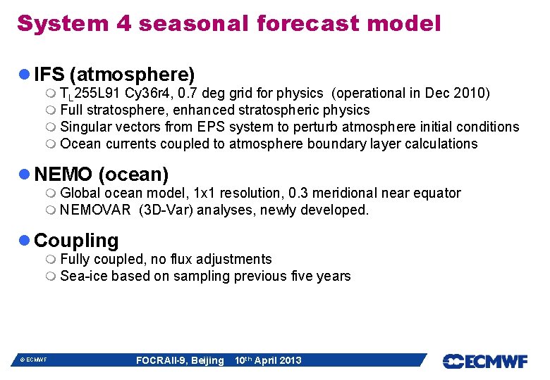
System 4 seasonal forecast model l IFS (atmosphere) m TL 255 L 91 Cy 36 r 4, 0. 7 deg grid for physics (operational in Dec 2010) m Full stratosphere, enhanced stratospheric physics m Singular vectors from EPS system to perturb atmosphere initial conditions m Ocean currents coupled to atmosphere boundary layer calculations l NEMO (ocean) m Global ocean model, 1 x 1 resolution, 0. 3 meridional near equator m NEMOVAR (3 D-Var) analyses, newly developed. l Coupling m Fully coupled, no flux adjustments m Sea-ice based on sampling previous five years © ECMWF FOCRAII-9, Beijing 10 th April 2013
Reduced mean state errors T 850 U 50 S 4 S 3 © ECMWF FOCRAII-9, Beijing 10 th April 2013
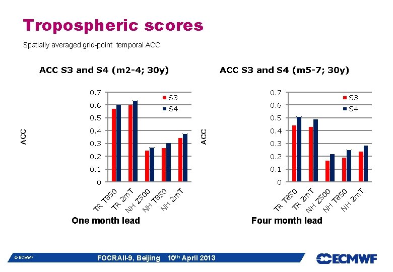
Tropospheric scores Spatially averaged grid-point temporal ACC 0. 6 0. 5 0. 4 T 50 H N Four month lead 10 th April 2013 T 8 00 T 50 T 8 TR 2 m H T 8 N N H Z 5 H 2 m N TR T 8 TR FOCRAII-9, Beijing Z 5 0 T 0 50 0. 1 00 0. 1 T 0. 2 50 0. 2 One month lead © ECMWF 0. 3 H ACC 0. 5 S 4 2 m S 4 0. 3 S 3 N 0. 6 ACC 0. 7 S 3 TR 0. 7 ACC S 3 and S 4 (m 5 -7; 30 y) 2 m ACC S 3 and S 4 (m 2 -4; 30 y)
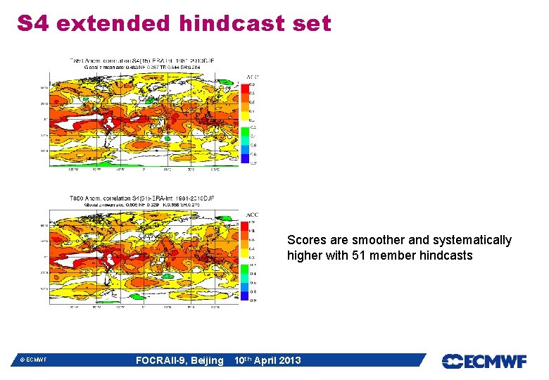
S 4 extended hindcast set Scores are smoother and systematically higher with 51 member hindcasts © ECMWF FOCRAII-9, Beijing 10 th April 2013
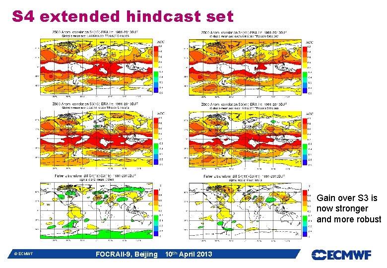
S 4 extended hindcast set Gain over S 3 is now stronger and more robust © ECMWF FOCRAII-9, Beijing 10 th April 2013
More recent ENSO forecasts are better. . 1981 -1995 © ECMWF 1996 -2010 FOCRAII-9, Beijing 10 th April 2013
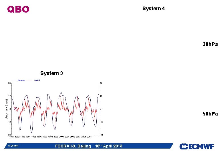
QBO System 4 30 h. Pa System 3 50 h. Pa © ECMWF FOCRAII-9, Beijing 10 th April 2013
Problematic ozone analyses © ECMWF FOCRAII-9, Beijing 10 th April 2013
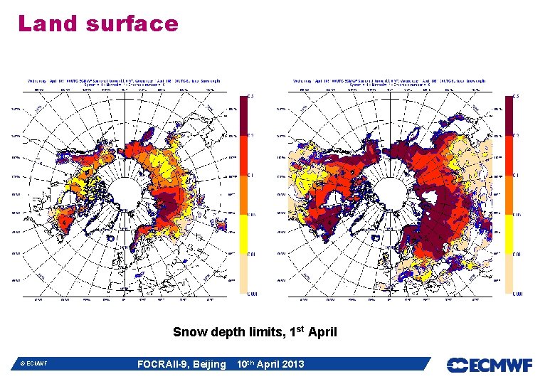
Land surface Snow depth limits, 1 st April © ECMWF FOCRAII-9, Beijing 10 th April 2013
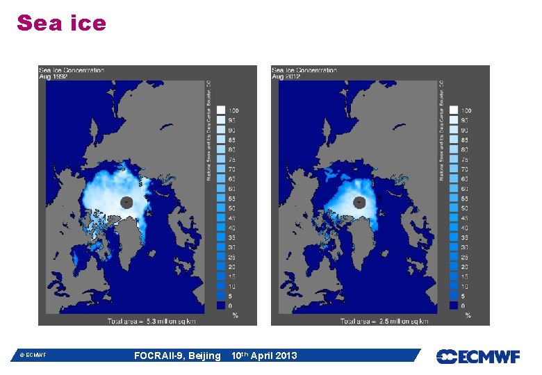
Sea ice © ECMWF FOCRAII-9, Beijing 10 th April 2013
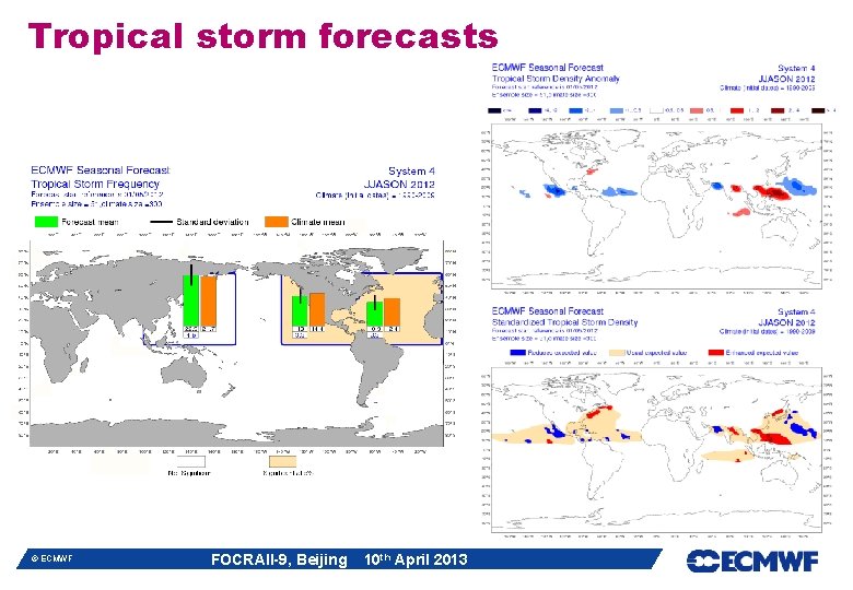
Tropical storm forecasts © ECMWF FOCRAII-9, Beijing 10 th April 2013
Recent Research © ECMWF FOCRAII-9, Beijing 10 th April 2013
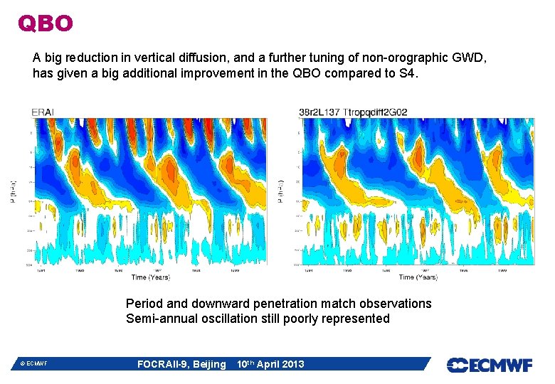
QBO A big reduction in vertical diffusion, and a further tuning of non-orographic GWD, has given a big additional improvement in the QBO compared to S 4. Period and downward penetration match observations Semi-annual oscillation still poorly represented © ECMWF FOCRAII-9, Beijing 10 th April 2013
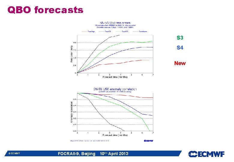
QBO forecasts S 3 S 4 New © ECMWF FOCRAII-9, Beijing 10 th April 2013
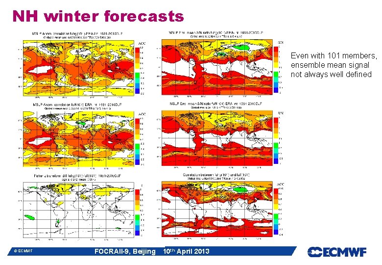
NH winter forecasts 0. 371 0. 319 © ECMWF FOCRAII-9, Beijing 10 th April 2013
NH winter forecasts Even with 101 members, ensemble mean signal not always well defined © ECMWF FOCRAII-9, Beijing 10 th April 2013
NH winter forecasts New version has weaker signal, more noise © ECMWF FOCRAII-9, Beijing 10 th April 2013
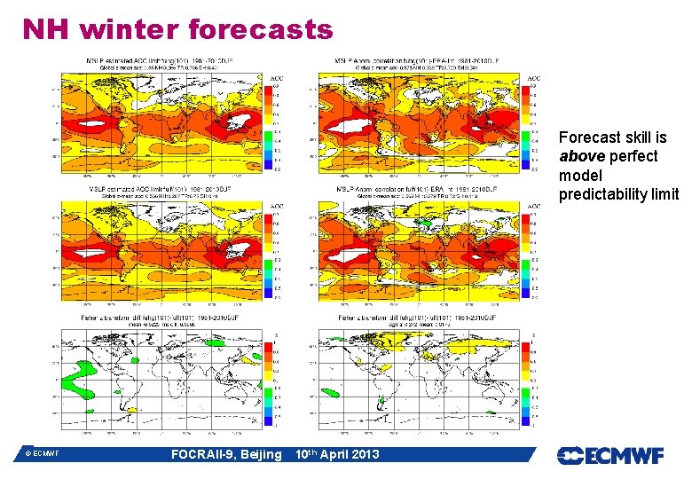
NH winter forecasts Forecast skill is above perfect model predictability limit © ECMWF FOCRAII-9, Beijing 10 th April 2013
EUROSIP l A European multi-model seasonal forecast system m Operational since 2005 m Data archive and real-time forecast products m Initial partners: ECMWF, Met Office, Météo-France m NCEP an Associate Partner; forecasts included since 2012 m Products released at 12 Z on the 15 th of each month m Aim is a high quality operational system m Data policy issues are always a factor in Europe © ECMWF FOCRAII-9, Beijing 10 th April 2013
Recent changes: variance scaling l Robust implementation m Limit to maximum scaling (1. 4) m Weakened upscaling for very large anomalies l Improves every individual model l Improves consistency between models l Improves accuracy of multi-model ensemble mean © ECMWF FOCRAII-9, Beijing 10 th April 2013
Revised Nino plumes © ECMWF FOCRAII-9, Beijing 10 th April 2013
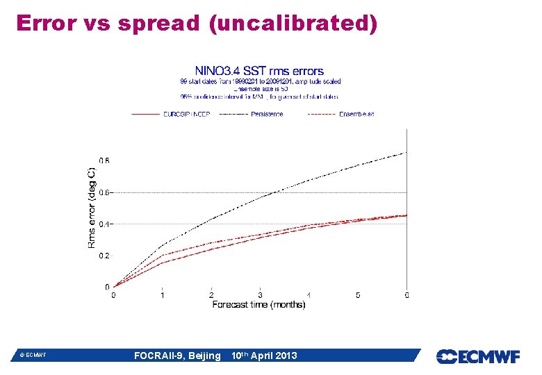
Error vs spread (uncalibrated) © ECMWF FOCRAII-9, Beijing 10 th April 2013
Calibrated p. d. f. l ENSO forecasts have good past performance data m We can calibrate forecast spread based on past performance m We can also allow varying weights for models m We have to be very careful not to overfit data at any point. l Represent forecast with a p. d. f. m This is the natural output of our calibration procedure m Easier visual interpretation by user l Calibration and combination in general case m Ideally apply similar techniques to all forecast values (T 2 m maps etc) m More difficult because less information on past (higher noise levels) m Hope to get there eventually …. . . © ECMWF FOCRAII-9, Beijing 10 th April 2013
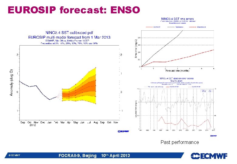
Nino 3. 4 plume and p. d. f. © ECMWF FOCRAII-9, Beijing 10 th April 2013
P. d. f. interpretation l P. d. f. based on past errors m The risk of a real-time forecast having a new category of error is not accounted for. E. g. Tambora volcanic eruption. m We plot 2% and 98%ile. Would not go beyond this in tails. m Risk of change in bias in real-time forecast relative to re-forecast. l Bayesian p. d. f. m Explicitly models uncertainty coming from errors in forecasting system m Two different systems will calculate different pdf’s – both are correct l Validation m Rank histograms show pdf’s are remarkably accurate (cross-validated) m Verifying different periods shows relative bias of different periods can distort pdf – sampling issue in our validation data. © ECMWF FOCRAII-9, Beijing 10 th April 2013
Forecasts for JJA 2013 © ECMWF FOCRAII-9, Beijing 10 th April 2013
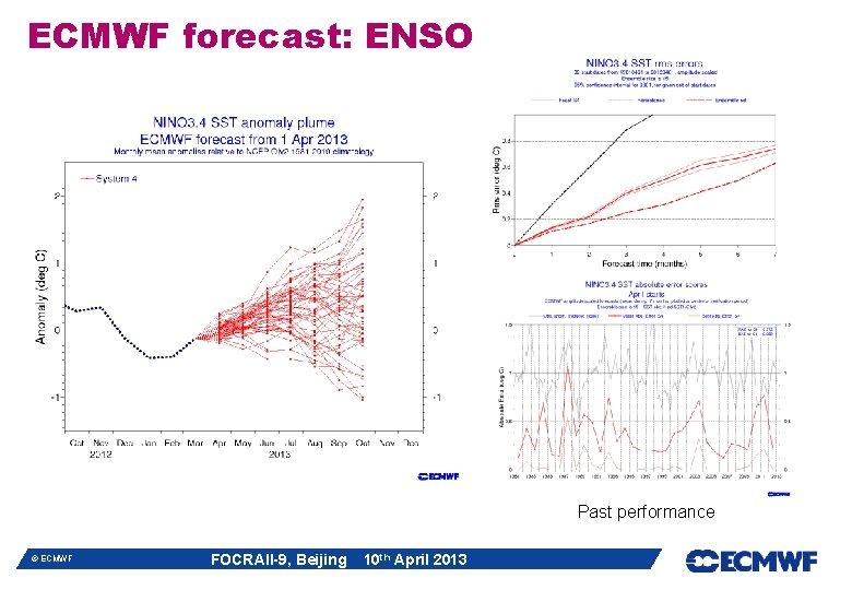
ECMWF forecast: ENSO Past performance © ECMWF FOCRAII-9, Beijing 10 th April 2013
EUROSIP forecast: ENSO Past performance © ECMWF FOCRAII-9, Beijing 10 th April 2013
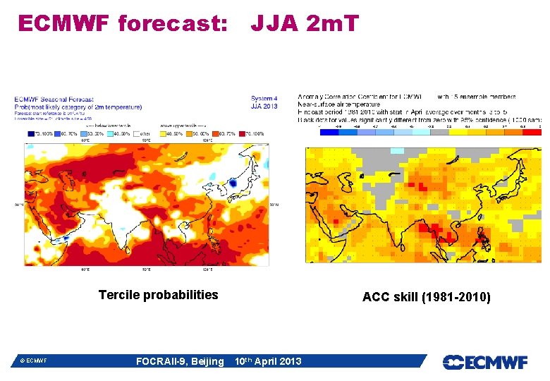
ECMWF forecast: JJA 2 m. T Tercile probabilities © ECMWF FOCRAII-9, Beijing ACC skill (1981 -2010) 10 th April 2013
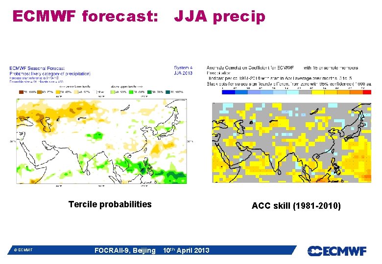
ECMWF forecast: JJA precip Tercile probabilities © ECMWF FOCRAII-9, Beijing ACC skill (1981 -2010) 10 th April 2013