Minnesota Geospatial Information Office A Program Area of


 Government IT Symposium (Dec 5 -6)")


 Does your county maintain a staff commitment to geospatial work? (Check")

 Which department in your county is a steward of your geospatial")

")
 What types of GIS data are commonly requested? • • •")


 How do you distribute your GIS data? • • Minnesota Geospatial")


 Is your county considering making its geospatial data freely available")


 Please estimate the amount of revenue generated from the sale")


 A significant commitment has been made")
 The broad reach and extensive use")
 What data is being asked for")
 Uncertainty & Wide Range of Practices")
 Key Concerns about Open Data: •")


 counties are making their")


- Slides: 73
Minnesota Geospatial Information Office A Program Area of MN. IT Services Welcome - Introductions - Update on Members - Approve Agenda - Approve September Minutes
Minnesota Geospatial Information Office A Program Area of MN. IT Services Agenda Item 2 Discussion & Action Statewide Project Prioritization Mark Kotz
Why Prioritize Projects? • Part of our Mission: • Statutes 16 E. 30, subd. 8: The Geospatial Advisory Council must advise the Minnesota Geospatial Information Office regarding the improvement of services statewide through the coordinated, affordable, reliable, and effective use of geospatial technology. • Mn. Geo can align limited resources to the projects most valuable to the community and most likely to succeed Minnesota Geospatial Information Office A Program Area of MN. IT Services
Why Prioritize Projects? • Can identify valuable projects that can move forward with minimal or no Mn. Geo resources = GAC committee/ workgroup • Can identify gaps in the likelihood of success for high value projects and recruit accordingly • Informs work plans for next year Minnesota Geospatial Information Office A Program Area of MN. IT Services
Project Prioritization Process • Create a list of proposed projects • Existing and GAC member input • Assess the value of each • GAC members advocate for sectors • 100% response! • Assess likelihood of success • Preliminary priority calculation • GAC discusses and adjusts Minnesota Geospatial Information Office A Program Area of MN. IT Services
Likelihood of Success • • What is the estimated effort? Is funding needed? Available Does a committed project owner exist? Project team? High level champion? Score factors in a prioritization matrix Review draft scores Minnesota Geospatial Information Office A Program Area of MN. IT Services
Setting Priorities Today 1. 2. 3. 4. 5. Review preliminary scoring in matrix Adjust likelihood of success factors Discuss gaps Create GAC priorities Limit list to a realistic number of projects Minnesota Geospatial Information Office A Program Area of MN. IT Services
Minnesota Geospatial Information Office A Program Area of MN. IT Services Agenda Item 3 Break – Networking
Minnesota Geospatial Information Office A Program Area of MN. IT Services Agenda Item 4 Discussion Review and Accept Committee and Workgroup Summaries
Minnesota Geospatial Information Office A Program Area of MN. IT Services Agenda Item 5 Discussion Li. DAR/Hydrography Panel and Results from GIS/LIS Conference Gerry Sjerven
Minnesota Geospatial Information Office A Program Area of MN. IT Services Agenda Item 6 Discussion Outreach Committee Update on Open Data Survey Len Kne and Kari Geurts
Minnesota Geospatial Advisory Council Outreach Committee Free + Open Geospatial Data Survey & “Narratives of Success” Brad Anderson, City of Moorhead Kari Geurts, Minnesota DNR, Outreach Committee Co-Chair Len Kne, University of Minnesota, Outreach Committee Co-Chair Geoff Maas, Metro. GIS Coordinator Michelle Trager, Rice County
What we’ll cover: Part II: Part III: Part IV: Part V: Context Survey Results Trends from the results Narratives of Success What’s next?
Part I: Context
Minnesota Geospatial Advisory Council Mission: Act as a coordinating body for the Minnesota geospatial community. http: //www. mngeo. state. mn. us/councils/statewide/index. html
Mission of the Outreach Committee: “Promote the value and importance of the geospatial infrastructure by actively engaging public policy makers and stakeholders”
Free + Open Data: Not uniform in Minnesota Purposes of the Survey: Understand document the full range of issues and concerns of the data producer community; Document success stories of GIS used to make government more efficient;
The Survey: >> Developed in July/August >> Sent out in late August >> Closed on Sept 30, 2016 >> 59 of 87 Counties* (~68% response rate) >> October: Compiled the results *Some counties had both their GIS and survey staff respond;
Results Available: MN GIS/LIS Conference (Oct 26 -28) Government IT Symposium (Dec 5 -6) Report available soon
Part II: Survey Results
The Questions: Differed slightly between counties; Depending on open and not open Structured questions, plus the opportunity to provide detailed written comments;
Question 1: Does your county maintain a staff commitment to geospatial work? (Check all that apply)
Question 1 (Other) Does your county maintain a staff commitment to geospatial work? (Check all that apply) • We have one (1) GIS specialist; • Business areas maintain data plus central/enterprise staff; • GIS falls under County Administrator duties; • Some GIS is done by the County, some is outsourced;
Question 2: Which department in your county is a steward of your geospatial data? (Check all that apply)
Question 2 (Other) Which department in your county is a steward of your geospatial data? (Check all that apply) • • Environmental Services (x 3) County Administrator’s Office (x 2) Community Works Human Services Health Drainage Administration Natural Resource Management
Question 3: How long has your county created and maintained geospatial data?
Question 4: What types of GIS data are commonly requested? (Check all that apply)
Question 4 (Other) What types of GIS data are commonly requested? • • • County Drainage County Ditch Systems Public Drainage Watersheds and Tile Centerlines PLSS corners Land surveying data
Question 5: Please estimate the number of nongovernment requests you receive each year for your geospatial data.
Question 6: How do you distribute your GIS data?
Question 6 (Other) How do you distribute your GIS data? • • Minnesota Geospatial Commons (x 2) Moving to an Open Data Portal (Arc. GIS Online Site) Via Dropbox Web site downloads
Question 7: Please estimate the number of hours county staff or vendors spend each week preparing data for external requests.
Question 8: Does your county provide its geospatial data freely and openly?
Question 9: Is your county considering making its geospatial data freely available in the near future?
Question 9 (Additional Comments) Is your county considering making its geospatial data freely available in the near future? RANGE OF ANSWERS RECEIVED: • No, not an issue; • No, it generates revenue; • No, staff supports it, leadership doesn’t support it • Some data is free, other data we sell; • Yes, we are considering it; • Yes, we are actively moving toward opening up;
Question 10: What concerns does your county have about making its geospatial data freely and openly available?
Question 11: Please estimate the amount of revenue generated from the sale of data each year.
Question 11 (Additional Comments) Please estimate the amount of revenue generated from the sale of data each year • Nothing for sale yet; • Price depends upon the request; • Respondents provided costs of their various datasets;
Question 12: What kinds of issues or obstacles did your county work through to make its GIS data freely and openly available?
Part III: Trends from the results
Major themes from the survey: # 1 ) A significant commitment has been made to GIS at the County level in Minnesota; • Dedicated staff to GIS • 67% of respondents: GIS for 10 or more year
Major themes from the survey: # 2 ) The broad reach and extensive use of GIS at the county level; 12+ departments acting as data stewards or creating data at the county government level;
Major themes from the survey: # 3 ) What data is being asked for from counties; Parcel data Road data Address point data Aerial imagery “The Big Four”
Major themes from the survey: # 4 ) Uncertainty & Wide Range of Practices >> Open Data >> Some data is free; some is sold/licensed >> All data sold/licensed >> Staff support for open data >> Unclear to leadership how to move
Major themes from the survey: # 5 ) Key Concerns about Open Data: • • Loss of Revenue Legal Liability ‘Bad actors’ misusing the data Privacy and security concerns Address these specifically in Part V
State Agencies: Issues with Non-Open Data published under a non-open license takes a significant amount of resources to manage. We have to store the data in a restricted folder and ensure that each data user understands and commits to the restrictions imposed by the license. David Fawcett Spatial Database Administrator Minnesota Pollution Control Agency Even though we can use the data under a non-open license, it is of lower value because of the license terms. We need to create a data product that we can distribute to the public, but can't base it on the non-open data because that would violate the terms of use. Instead, it will cost us a lot more to build it from scratch.
Part IV: Narratives of Success
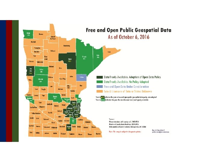
Free and Open GIS data status: At present: Twenty (20) counties are making their data freely and openly available; Since February 2014: Ten (10) County Boards have adopted Free + Open Data Resolutions
Benefits of Free and Open GIS data from the Metro Counties open data experience > Less time/effort for data producers; > Pro-active government; > Ease of access to data to entire consumer community; > Fostering entrepreneurship/business development; > Transparency of government operations; > Faster decision making; > Maximizes public investment in GIS;
Question 13: Are you experiencing benefits from making your geospatial data freely and openly available? If so, please summarize or describe those benefits. • No managing of license agreements • Public able to acquire the data themselves (selfservice) • Saves our staff time • Reduced administrative burden • Frees up time for other projects • Requests directed to staff are definitely down • Staff can focus on data quality and data management
Question 13: Are you experiencing benefits from making your geospatial data freely and openly available? If so, please summarize or describe those benefits. “Organizations like Zillow, Black Knight, Core. Logic have already been directed to get their data from the Commons. Our tax folks are wishing to publish CAMA and tax information tables to the Commons for use with the parcel GIS layer to further cut down on requests coming to their offices”;
Business Community: Benefits of Free and Open GIS data Northstar. MLS provides Real Estate listing services to it's subscribers who provide great benefit to both buyers and sellers of real property throughout Minnesota and Wisconsin. Curt Carlson, GIS Coordinator Northstar. MLS Having free and open parcel GIS data allows Northstar. MLS to confirm and improve the geo-positional accuracy as well as the characteristics of the data of over 42, 000 currently active Real Estate listings in 103 counties in Minnesota and Wisconsin. Without free and open data, listing accuracy is compromised and this results in inaccurate searches and delays for buyers and sellers alike. Having access to free and open GIS data allows us to better serve the general public in as large an area as possible.
Public Health: Benefits of Free and Open GIS data Linda Glaser, Senior Veterinarian During the 2015 highly pathogenic avian influenza outbreak, timely access to locational data was essential for an effective and efficient response. Lessons learned from this animal disease response and ongoing preparation for future animal disease emergencies highlight the need for the best locational data available. In Minnesota, having up-to-date parcel GIS data accessible is extremely important to the Board of Animal Health for the ability to identify landowners with livestock and poultry. With this information, we can contact producers to provide information and enable a swift response to animal disease emergencies.
Office of the State Auditor: Benefits of Free and Open Data Rebecca Otto MN State Auditor The goal of these comprehensive maps is to improve public policy/long-term financial planning and asset-management planning for our civil infrastructure throughout Minnesota's 853 cities and other local governments. By improving transparency of our infrastructure needs, all residents, local elected officials, legislators and governors will have a more comprehensive understanding of the total need over the next few decades statewide. This understanding can accelerate better planning, stabilize rates for users, and avoid major service disruptions due to inaction.
Counties: Benefits of Free and Open GIS data Michelle Trager GIS Coordinator Rice County We receive many data requests for GIS data, especially from other government entities and contractors. Parcels, road centerlines, address points and imagery are the most commonly requested layers. I requested that our county share our data so I could spend less time filling requests, and still help other entities meet their business needs. In August, we received permission to go ahead with Free and Open Data. I am working with Mn. Geo to add data to the Minnesota Geospatial Commons. I am looking forward to being able to spend time working on other tasks like updating and creating Arc. GIS Online maps.
Cities: Benefits of Free and Open GIS data Brad Anderson GIS Manager City of Moorhead As a creator, maintainer, and provider of GIS data for the City of Moorhead, I find most requests prefer a County-wide set of data. We have nightly tasks that exchange GIS and tax ownership data back and forth with Clay County. City specific data requests typically include underground utilities, parcels, elevation, easements, zoning/land use, flood mitigation, and miscellaneous historical data. I plan to setup an Open Data Portal to reduce my time spent filling requests, …. . the only caveat being that I like to know how the data is being used AND receiving feedback on any errors so that I can make our data better. Which would benefit everyone.
Non-Profit Sector: Benefits of Free and Open GIS data We use geospatial science to address and resolve social justice and natural resource conservation issues. Andra Bontrager GIS Specialist Minnesota Center for Environmental Advocacy The usefulness and efficiency of the spatial analyses that we perform is tied directly to the availability and quality of data that we can obtain for their implementation. Having public GIS data that is readily available is imperative to our mission of advocating for the sustainability of our common resources.
Academia: Benefits of Free and Open GIS data My GIS students are primarily pursuing graduate-level degrees in Urban and Regional Planning and Public Policy. Geoff Maas Lecturer Humphrey School of Public Affairs, University of Minnesota Having unfettered access to government geospatial data at all levels (city, county, regional, state and federal) is a vital component to not only their ability to use GIS and perform spatial analysis but to fully understand the functions and operation of government. Being able to access and use the geospatial data as prepared by its authoritative sources is crucial for providing an authentic and valuable educational experience.
Part V: What’s next?
Technology is not the issue
Addressing the Specific Concerns Raised by Survey Respondents Loss of Revenue Legal Liability ‘Bad actors’ misusing the data Privacy and security concerns
Loss of Revenue generated from the sale of data; Vs. Staff time committed to fulfilling requests; Time taken away from other work;
Legal Liability Chapter 466. 03, Subd. 21 Under state law: As long as you provide a disclaimer with your data you are exempt from liability;
‘Bad actors’ misusing the data Privacy and security concerns The data contained in parcel data are public information: Owner, address, value of land improvements and the taxes paid; Affirmed in several places in state statue; Chapter 13, also § 389. 02, § 505. 04;
‘Bad actors’ misusing the data Privacy and security concerns Protection of the location and identity of women’s shelters; ‘Safe At Home’ Law (§ 13. 045) These data are redacted/stripped out prior to entering the GIS data stream;
Resources: metrogis. org > Projects > Free + Open Data Single Page Fact Sheet “White Paper I” • • • Statutes, Disclaimers Law Case Summaries Interviews with practitioners “White Paper II” • • • FAQs Resources for practitioners Links to government sites
What’s next? • Questions • Comments • Discussion
Minnesota Geospatial Information Office A Program Area of MN. IT Services Agenda Item 7 Discussion Geospatial Community Calendar and Discussion Forum – GIS/LIS Board Feedback Gerry Sjerven
Minnesota Geospatial Information Office A Program Area of MN. IT Services Agenda Item 8 Discussion Legislative Updates Dan Ross
§ Clean Water Fund Language § Approved to move forward § Parks and Trails Legacy Fund (U of M) § Current focus is on data standard § Responsive Website for Parks and Trails (DNR) § Survey to help determine website design § Click here to take the survey § Buffer Mapping Project – updated data
Agenda Item 9 Discussion Announcements or Other Business Minnesota Geospatial Information Office A Program Area of MN. IT Services