Lidar applications to atmospheric studies Dr Juan Carlos


: P(r): Received power (r): Volume backscatter coefficient at range r")
 Calculating the logarithm")


- Slides: 29
“Lidar applications to atmospheric studies. " Dr. Juan Carlos Antuña Marrero Senior Researcher, Grupo de Óptica Atmosférica de Camagüey (GOAC), Instituto de Meteorología, Cuba Winter College on Optics: Light: a bridge between Earth and Space The Abdus Salam International Centre for Theoretical Physics February, 16 th 2015
Winter College on Optics Light: a bridge between Earth and Space The Abdus Salam International Centre for Theoretical Physics Conference: Lidar applications to atmospheric studies. Summary 1. Brief Lidar history 2. Lidar equation & solutions 3. Lidar applications: • Stratospheric aerosols • Cirrus clouds 4. Space Lidars • LITE • CALIPSO
1. Brief Lidar history
Radar: RAdio Detection And Ranging 1887: Heinrich Herzt began experiments with radio waves 1920 – 1930: Renew efforts for creating an emitter-receptor WW II: Accelerated military applications (Because clouds Interference) From 1945 Development of the Meteorological Radar Electromagnetic Spectra Range = C * (time/2) C: Light speed
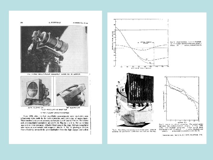
In the 30’s began efforts to measure density profiles in the high atmosphere using dispersed signals from searchlights Synge, E. H. Phil. Mag. 9, 1014, 1930. 1938: Cloud base measured by 1 st time using pulsed light Bureau, R. La Meteorologie, 3, 292, 1946. Acronym LIDAR coined in 1953 Middleton W. E. K. and A. F. Spilhaus, Meteorological Instruments (University of Toronto Press), Toronto 1953. Between 40’s & 50’s renewed efforts using searchlights to measure high atmosphere density, temperature and aerosols profiles Elterman, L. , Seasonal trends of temperature, density and pressure to 67. 6 km obtained with the searchlight probing technique. J. Geophys. Res. , Vol. 59(3), pp. 351 -358, 1954. Ruby laser invented in 1960: a better emission source Lidar atmospheric studies phases: 1960 s – 1970 s: Innovation (many pioneering demonstration experiments) 1970 s – today : Development (improved lasers, hardware and theory) 1970 s – today : Application (many lidar developed and working getting important and often unique data)
What is a Lidar? LIght Detection And Ranging Lidar Systems • Laser System • Optical System • Register System (Detection) • Control & Operation System Simple Lidar design
LASER: Light Amplification by the Stimulated Emission of Radiation Main laser features: Monochromatic: Only one wavelength Collimated: Beam of light which has a low beam divergence, so that the beam radius does not undergo significant changes Coherent: Constant relative phases between radio wave pulses Nd: Yag Laser Solid state laser Active Medium: Cristal YAG (Yttrium Aluminum Garnet) Y 2 Al 5 O 12 Dopant YAG: Nd Y+3 ions replaced by Nd+3 ions Emission Wavelength: 1064 nm
2. Lidar equation & its solutions.
Lidar Equation (Simplest form): P(r): Received power (r): Volume backscatter coefficient at range r (r): Volume extinction coefficient at range r C: Calibration constant (depends on laser power, laser pulse with, receiver area, instrument optical transmission and detector efficiency) Considering the aerosol and molecular components of the atmosphere: (r) = par(r) + mol(r) and (r) = par(r) + mol(r) EXTINCTION-BACKSCATTER RATE (LIDAR RATE) parameter strongly related to the microphysical aerosols properties - aerosol type - size distribution relative humidity Unlike and , LR doesn’t depend on aerosol amount, but only on aerosol type Examples: ~ 10 sr (ice crystals); ~ 20 -30 sr (maritime aerosols); ~ 60 -70 sr (urban aerosol) ~ 100 sr (heavy polluted air) Processing Algorithms : 1. Slope Method 2. Total Integrated Backscatter 3. Inverse Modeling 4. Analytical Inversion An important simplification: no multiple scattering accounted for
Slope Method: Based on the assumption of a homogeneous atmosphere: (r) Calculating the logarithm of the range corrected backscatter signal Z: The extinction coefficient = par + mol can be derived from the gradient: Because of the initial assumption could be calculated from the slope of the range corrected signal Z Total Integrated Backscatter: Requires calibrated lidar system and information about the backscatter/extinction ratio k= 1/LR. The total integrated backscatter signal (U) is defined as: It can be shown that:
Inverse Modeling: Well known method for retrieving physical parameters in remote sensing. Main idea: make use of a forward model to model the observed signal, depending on a set of parameters, to be retrieved. The difference between observed and modeled parameters is minimized in general using iterative procedures. Two particular methods are: Iterative algorithm (Kästner, 1987) Information-theoretic method (Yee, 1989) Analytical Inversion: Most frequently used method because it is the exact mathematical solution of the lidar inversion problem. It could be performed in two ways: forward and backward integration. Considers the existence of the lidar ratio (LR) Algorithm known as refined scattering ratio (Russell et al, 1979: Methodology for error analysis and simulation of lidar aerosol measurements. App. Opt. , 18, pp. 3783 -3797).
Forward Integration Method Advantages Boundary value can be replaced by lidar calibration constant Disadvantages Unstable in turbid atmosphere Near-end boundary value or calibration necessary References Fernald et al. , 1972 Fernald, 1984 Kovalev & Moosmüller, 1994 Backward Integration Method Advantages Stable in turbid atmosphere Disadvantages References Far-end boundary Klett, 1981; 1983; 1985 value generally can not Sasano & Nakane, 1984 be determined Fernald, 1984 Kovalev and Moosmüller, 1994
3. Lidar applications: • Stratospheric aerosols • Cirrus clouds
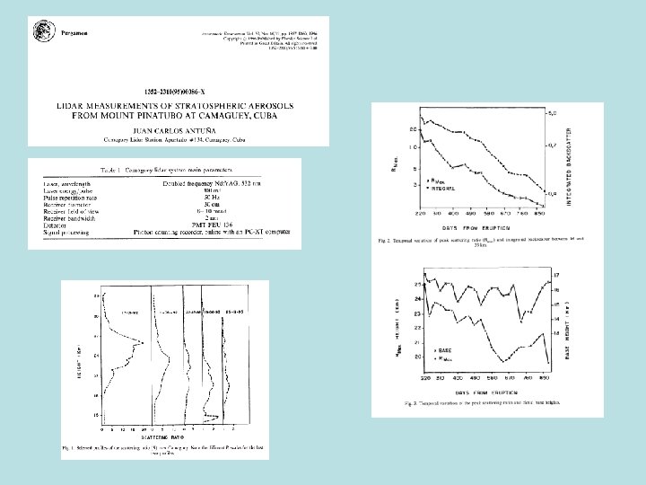
Mt. Pinatubo stratospheric aerosols e aus pop tro
“Cirrus clouds lidar measurements”
4. Space Lidars
Space Based Lidars Functionality 2006 2016
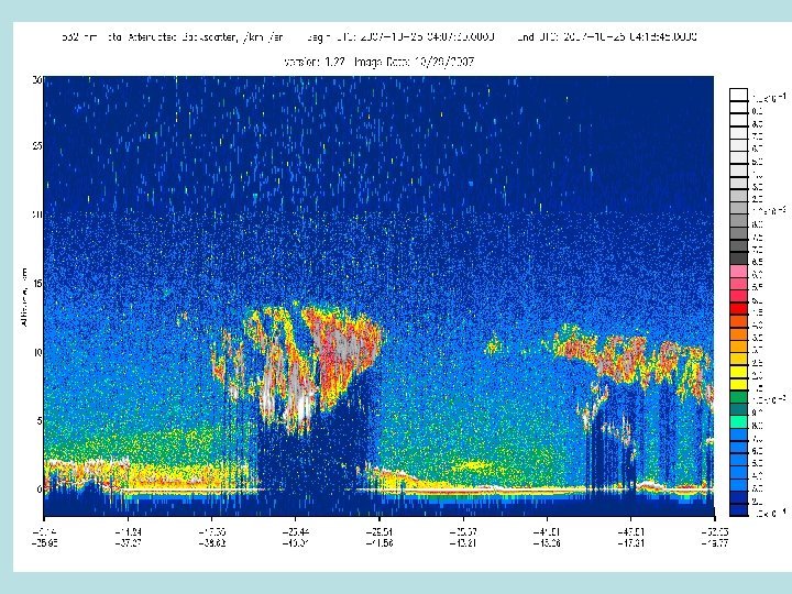
LITE : LIdar Technology Experiment LITE on board STS-64 Discovery mission September 9 -20 1994 First sucesful mission using a lidar for atmospheric research Aerosols and clouds measured Tomado de: http: //www-lite. larc. nasa. gov/
Mount Atlas 5 minutes LITE measurement Sahara overpass September 18, 1994. Ø Mount Atlas separate dense aerosols mass east of a clear west Ø More west over the desert a complex mass of aerosols reaching 5 km altitude
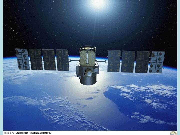
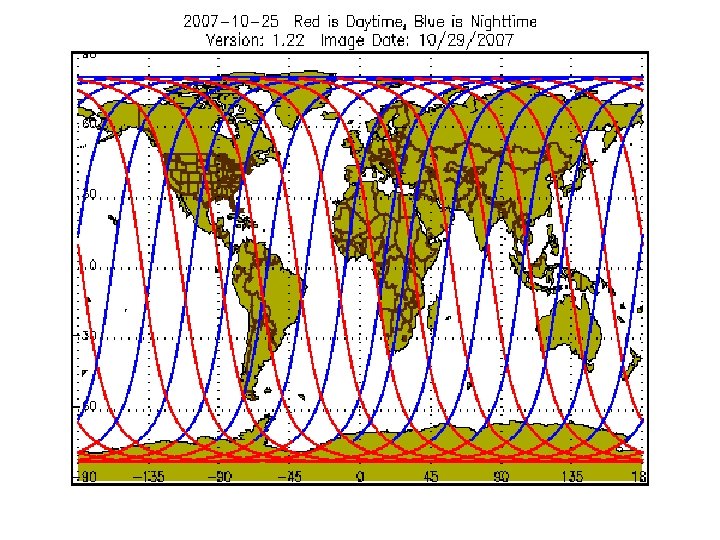
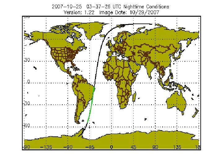
CALIPSO: Cloud-Aerosol Lidar and Infrared Pathfinder Satellite Observation Mission for measuring clouds and aerosols Designed for 3 years Operative 2006 to the present PICASO-CENA: Pathfinder Instruments for Cloud and Aerosol Spaceborne Observations – Climatologie Etendue des Nuages et des Aerosols Tomado de: http: //www-calipso. larc. nasa. gov/
CALIPSO Tomado de: http: //www-calipso. larc. nasa. gov/
Sistemas de Control y Operación del CALIPSO
Muchas Gracias.