Overview What is LIDAR Example schematic LIDAR return
- Slides: 8

Overview • What is LIDAR • Example (schematic) LIDAR return and interpretation • Map of sites to be analyzed (1 shown here, 2 -5 as student exercises) • Aerial photograph comparison of before and after Hurricane Irene for the North Carolina “Location 1”

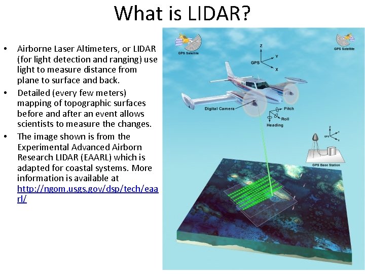
What is LIDAR? • • • Airborne Laser Altimeters, or LIDAR (for light detection and ranging) use light to measure distance from plane to surface and back. Detailed (every few meters) mapping of topographic surfaces before and after an event allows scientists to measure the changes. The image shown is from the Experimental Advanced Airborn Research LIDAR (EAARL) which is adapted for coastal systems. More information is available at http: //ngom. usgs. gov/dsp/tech/eaa rl/

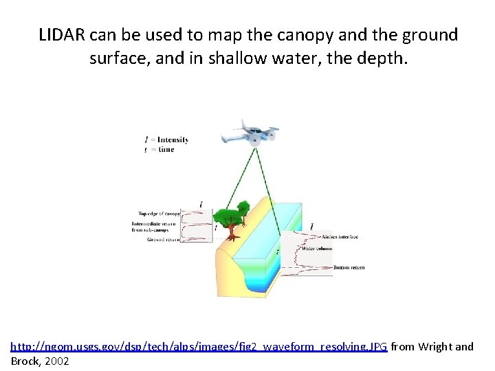
LIDAR can be used to map the canopy and the ground surface, and in shallow water, the depth. http: //ngom. usgs. gov/dsp/tech/alps/images/fig 2_waveform_resolving. JPG from Wright and Brock, 2002

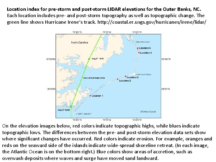
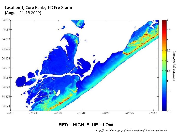
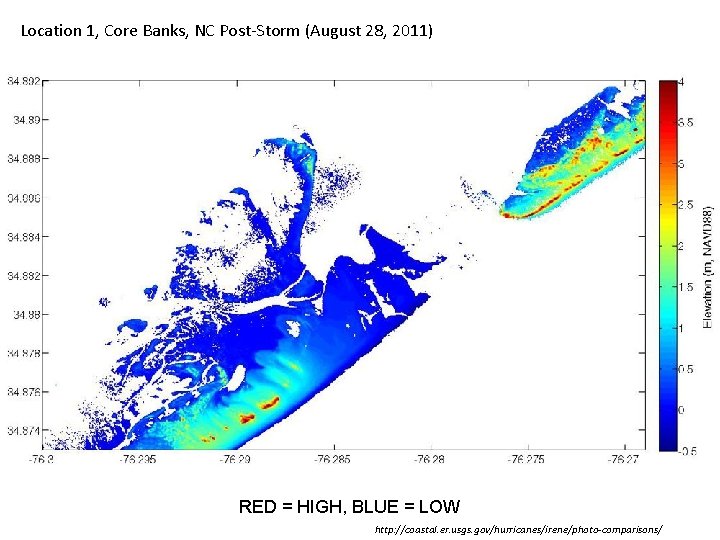
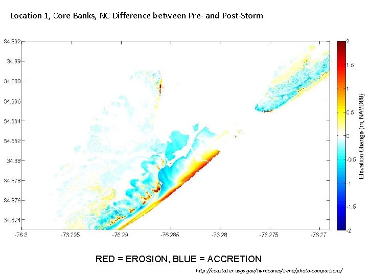
Location index for pre-storm and post-storm LIDAR elevations for the Outer Banks, NC. Each location includes pre- and post-storm topography as well as topographic change. The green line shows Hurricane Irene’s track. http: //coastal. er. usgs. gov/hurricanes/irene/lidar/ On the elevation images below, red colors indicate topographic highs, while blues indicate topographic lows. The differences between the pre- and post-storm elevation data sets show where significant changes have occurred. Red colors indicate erosion. For example, oranges and reds on the seaward side of the islands indicate wide-spread shoreline retreat. (In each image, the Atlantic Ocean is on the bottom right. ) Blue colors show areas of accretion, such as overwash deposits where waves and surge have moved sand landward.

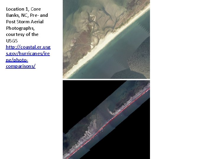
Location 1, Core Banks, NC, Pre- and Post Storm Aerial Photographs, courtesy of the USGS http: //coastal. er. usg s. gov/hurricanes/ire ne/photocomparisons/

Location 1, Core Banks, NC Pre-Storm (August 11 -15 2009) RED = HIGH, BLUE = LOW http: //coastal. er. usgs. gov/hurricanes/irene/photo-comparisons/

Location 1, Core Banks, NC Post-Storm (August 28, 2011) RED = HIGH, BLUE = LOW http: //coastal. er. usgs. gov/hurricanes/irene/photo-comparisons/

Location 1, Core Banks, NC Difference between Pre- and Post-Storm RED = EROSION, BLUE = ACCRETION http: //coastal. er. usgs. gov/hurricanes/irene/photo-comparisons/