Lecture 10 Engineering Geology and Seismology Volcanoes Types





- Slides: 106

Lecture # 10 Engineering Geology and Seismology Volcanoes Types, Nature and products of erutions Instructor: Prof. Dr. Attaullah Shah Department of Civil Engineering City University of Science and IT Peshawar 1

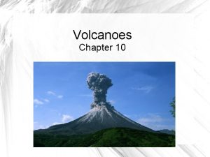
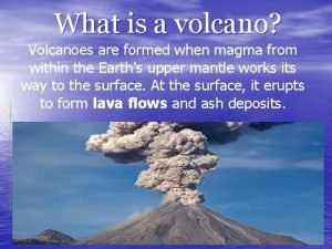
Volcano: A mound of material that is extruded to the Earth’s surface from a vent that is connected to a magma chamber via a feeder conduit.

Volcanoes are classified according to their form. The form of a volcanoes depends on the type of material that it is made up of. The nature of the extruded material (and the volcano itself) depends on the properties of the magma. Magma: Molten rock within the Earth. Magma is called lava when it reaches the surface.

The composition of magma determines the type of rock that forms when it cools and its behavior during an eruption. Main controls on behavior: chemical composition (largely silica dioxide - Si. O 2 content) and gas content (largely water vapor and CO 2). Si. O 2 content controls the viscosity of a magma. Viscosity: a measure of how easily a fluid flows. Water has a low viscosity, molasses has a much higher viscosity.

Viscosity, in turn, controls the amount of gas that can be trapped in the magma. The greater the viscosity the more gas in the magma. There are three basic types of magma: Basaltic Magma Andesitic Magma Rhyolitic Magma The names are based on the rock type that forms when the magma crystallizes.

Magma Type Chemical Composition Basaltic 45 -55% Si. O 2; High in Fe, Mg, Ca; Low in K, Na. Andesitic 55 -65% Si. O 2; Intermediate Fe, Mg, Ca, Na, K Rhyolitic 65 -75% Si. O 2; Low in Fe, Mg, Ca; High in K, Na Temperature Viscosity (degrees C) 1000 - 1200 Low Gas Content Low 800 -1000 Intermediate 650 -800 High

Overall, the behaviour of the magma determines the type of volcano that develops: Low Si. O 2 magmas, with little gas and low viscosity, flows readily through their vents and across the land surface when the lava escapes the vents. High Si. O 2 magmas, gaseous and with high viscosity, tend to plug their vents until the force of escaping magma blows the vent clear; such magmas cause explosive volcanoes.

Types of volcanic deposits (photos from USGS) Volcanoes also vary in terms of the types of deposits that they produce. Lava: Hot (up to 1200 degrees C), fluid, molten rock that flows along the land surface.

Lava can flow like viscous water, including forming lava falls.

Pahoehoe: Lava with a ropelike surface texture due to partial cooling as the lava flowed. Relatively hot, low viscosity lava.

Pahoehoe

A thick deposit of pahoehoe lava

Aa: Blocky, rough lava flow. Due to high viscosity lava that flowed pushing chunks of solid and semi-solid blocks.

Lava tube: A tube formed by cooling and solidifying of the lava walls while fluid lava continued to flow inside.

Pillows: A form of closed lava tube (with a bulbous end) that forms when a lava flows into water (e. g. , a lake or ocean) and cools very rapidly. http: //oceanexplorer. noaa. gov/explorations/04 fire/background/volcanism/media/pillow_lava_video. html Pyroclastic material: Debris formed by a volcanic explosion. Results when magma is very viscous. Tephra: The general term for all pyroclastic material that is ejected from a volcano. Different terms apply according to the size of the tephra. (syn. Ejecta)

Ash: tephra that is finer than 2 mm in diameter.

Lapilli: from 2 mm to 64 mm in diameter. Blocks: hard fragments greater than 64 mm in diameter.

Bombs: soft, partially melted fragments greater than 64 mm in diameter.

Tuff: A deposit made up of ash. Welded tuff: A deposit of pyroclastic material that was laid down while still very hot and particles become fused together. Ash fall: Fallout of very fine ash from the air. Volcanic ash fall during mid-day with the eruption of Mount Pinatubo in the Philippines.

Ash flow: Pyroclastic debris that flows downslope. Lahar: A water saturated slurry of ash and other volcanic debris that flows downslope.

Nuée Ardente (glowing cloud): A hot, gaseous cloud of ash that flows down slope. Flow speeds can reach 160 km/hr and temperatures can exceed 600 degrees C. http: //volcano. und. nodak. edu/vwdocs/volc_images/img_mt_pelee. html

Classification of volcanoes Volcanoes are classified according to their morphology. The processes and deposits dictate the morphology of volcanoes. Three types of volcano:

Shield volcanoes: dominated by lava flows. Muana Loa Volcano – the world’s largest volcano. http: //hvo. wr. usgs. gov/maunaloa/ Photograph by J. D. Griggs on January 10, 1985

Cinder cones: dominated by pyroclastics. Forms an isolated conical mound of tephra. Photograph by J. P. Lockwood on 1 December 1975 http: //volcanoes. usgs. gov/Products/Pglossary/Cinder. Cone. html

Stratovolcanoes: mixture of lavas and pyroclastics. Syn. Composite volcanoes Mount Mageik volcano, Alaska Photograph by R. Mc. Gimsey on 15 July 1990 http: //volcanoes. usgs. gov/Products/Pglossary/stratovolcano. html

Shield Volcanoes Dominated by fluid, high temperature, low viscosity basaltic magma. Low, dome-shaped profile, like an inverted shield. http: //geoimages. berkeley. edu/Geo. Images/Johnson/Landforms/Volcanism/Shield. Volcano. html

Typical slopes approximately 15 degrees. Lava flows downslope, away from a central vent or a series of vents. Many shield volcanoes have a central caldera: Calderas form after an eruption when the surface collapses. Each caldera is located at the site of a former eruption. USGS

Low viscosity lava forms fountains of lava flowing from vents near the volcano summit.

The lava flows easily down the gentle slopes…. reaching the ocean during some eruptions.

Where the lava is relatively cool eruptions form small cinder cones on the volcanoes surface.

Cinder Cones Dominated by viscous, gaseous magmas Relatively cool basaltic magmas or andesitic magmas predominate. Mount Edziza, British Columbia

Internally constructed entirely of layers of pyroclastic deposits (blocks, bombs, lapilli). Slopes are steep, at angle of repose. Angle of repose: the natural maximum angle that a pile of loose, unconsolidated material will form.

Typical angles: 30 to 40 degrees. Range from several metres to over 300 m in height. Commonly associated with old shield volcanoes with a relatively cool, basaltic magma.

Stratovolcanoes Volcanoes that alternate between periods of lava flows (constructive phase) and periods of explosive eruptions (destructive phase). Commonly called “composite volcanoes” because they are made up of both lava and pyroclastic deposits. Steep slopes, at angle of repose or greater. © Noemi Emmelheinz 2001

May lay dormant for thousands of years. On average, andesitic magmas with a high gas content. Actually, a mix of basaltic and rhyolitic magmas in many cases. Gases add great pressure when the feeder conduit becomes plugged, contributing to the explosive power. Can grow to thousands of metres high during constructive lava flow phases. The constructive phase often ends with a destructive phase – an explosive eruption.

Mt. St. Helens Before Mt. St. Helens After

Extensive ash falls and ash flows are commonly produced during explosive phases.

After an eruption a large caldera remains. Crater Lake is a caldera that remains following an explosive eruption 7, 700 years ago. The eruption was 42 times more powerful than Mt. St. Helens.

The Distribution of volcanoes

The vast majority of volcanoes are located: Parallel to oceanic trenches. Along the oceanic ridge. Over hot spots originating from the mantle.

Volcanoes along trenches Examples: Japan, most Pacific Islands, Caribbean Islands, west coast of North and South America.

2/3 of all volcanoes are along the Ring of Fire that surrounds the Pacific Ocean.

Volcanoes result from magma rising off the melting subducted plate. The composition of the magma is andesitic (melted basaltic crust plus sediment carried on the crust). Magma is very gaseous, particularly enriched with water vapor. Stratovoclanoes are constructed from feeder conduits extending to the surface.

Granitic (rhyolitic) intrusions are also formed, becoming trapped within the volcanic pile overlying the region of subduction. Potential for very explosive eruptions.

Mt. Fuji, Japan A stratovolcano that has erupted 16 times since 781 AD. The most recent eruption was in 1707 -1708 0. 8 cubic km of ash, blocks, and bombs were ejected during that eruption. (Greater than Mt. St. Helens and there were no fatalities).

Similar situation on the west coast of North and South America. Volcanoes formed by intrusion into the mountain chains that result from compressive forces between oceanic and continental crust.


Volcanoes in Canada? There are many inactive volcanoes in the Canadian Rocky Mountains. None are erupting at the present time. At least three have erupted over the past several hundred years. For a catalogue of Canadian Volcanoes go to…. . http: //gsc. nrcan. gc. ca/volcanoes/map/index_e. php

Oceanic Ridge Volcanoes Most volcanic activity is under water. Intrusion of material from the magma chamber creates new oceanic crust as the sea floor spreads. Basaltic pillow lavas dominate the submerged volcanoes.

Shield volcanoes occur where volcanic activity extends to the surface (e. g. , Iceland). Iceland is growing by volcanic expansion of the ridge. Unlike Hawaiian volcanoes, Icelandic shield volcanoes deliver lava through fissures rather than central vents.

Volcanism associated with rifting Volcanism Associated with subduction

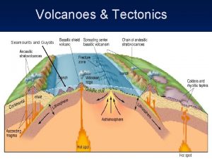
Volcanoes and Hot Spots Hot Spot: a point on the crust immediately above a hot plume within the mantle. Heat from the mantle (and some magma) rises to the hot spot. Rising mantle material termed a mantle plume.

Hot spots can occur beneath oceanic or continental crust. Mechanism first proposed by J. Tuzo Wilson (a Canadian geophysicist) to illustrate that plates actually move.

The Hawaiian Islands consist of eastern active volcanic islands and inactive volcanic islands to the northwest.

Further northwest of the islands are seamounts (underwater mountains that are submerged islands).

http: //www. biosbcc. net/ocean/marinesci/02 ocean/hwgeo. htm Just southeast of Hawaii is an undersea volcano known as Loihi.

Until 1996 Loihi was thought to be an inactive seamount. It began erupting in 1996 and the eruptions were preceded by a cluster of small earthquakes indicating the movement of magma.

The modern active island rests close to the hot spot and its shield volcanoes are fed from the magma that the hot spot generates. http: //www. biosbcc. net/ocean/marinesci/02 ocean/hwgeo. htm

The Pacific plate is moving towards the northwest. The volcanic islands have been successively “pushed off” the hot spot by plate movement.

As the crust moves it ages, becomes cooler and more dense, causing it to subside. The seamounts are old islands that have subsided to below sea level.

The seamounts represent even older islands that have been pushed further from the hot spot.

Recent studies suggest that the Hawaiian Hot Spot has moved over time.

Prediction of Volcanic Eruptions Long Term Prediction Identify volcanoes and the frequency and style of their eruptions (a geological problem). Establish probabilities of eruption, style and location for individual volcanoes. Establish the level of risk based on historic and geologic record. E. g. , for individual volcanoes: determine most likely routes for lahars, nuees ardentes, lava flows, etc. , and avoid construction in those areas.

Hazard zones have been distinguished around Mt. Shasta based on topography and past experience with eruptions. Zone 1: areas likely to be affected Zone 1 most frequently. Most future flows from summit eruptions probably would stay within this zone.

Hazard zones have been distinguished around Mt. Shasta based on topography and past experience with eruptions. Zone 1: areas likely to be affected Zone 2 most frequently. Most future flows from summit eruptions probably would stay within this zone. Zone 2: areas likely to be affected by lava flows erupted from vents on the flank of the volcano or that move into zone 2 from zone 1.

Hazard zones have been distinguished around Mt. Shasta based on topography and past experience with eruptions. Zone 1: areas likely to be affected Zone 3 most frequently. Most future flows from summit eruptions probably would stay within this zone. Zone 2: areas likely to be affected by lava flows erupted from vents on the flank of the volcano or that move into zone 2 from zone 1. Zone 3: areas likely to be affected infrequently and then only by long lava flows that originate at vents in zones 1 and 2

Short-term prediction Based on the recognition of a pattern of events prior to previous eruptions. Gas emissions: rates of emission and type of gas changes in some volcanoes. Important gases include sulfur dioxide (SO 2) and carbon dioxide (CO 2) Changes in concentration may reflect movement of the magma up the vent.

Surface tilting: recognition of changes in the land surface due to building pressure in the conduit. A surface bulge appeared on Mt. St. Helens prior to its eruption. April 8, 1980 April 26 May 2

Earthquakes: generated as the magma moves up the feeder conduit to the vent. When viscous magma becomes stuck in the conduit strain energy builds as more magma tries to push out. Movement takes place in a series of “jerks” as the rock material breaks. Each “jerk” produces an earthquake. Magnitudes generally less than 5 M. The more earthquakes the further the magma has moved.

Mount Spurr, Alaska: The 1992 Eruption of Crater Peak Vent USGS Black bars: earthquake frequency. Red lines: volcanic eruptions.

A combination of approaches is likely the key to short-term prediction.

The impact of volcanic eruptions

Volcanic Hazards Lava flows Commonly destroy property in Hawaii and Iceland. Damage limited to the vicinity in the immediate area of the volcano. Fatalities rare due to slow speed of advancing lava flow.

Ash fall Extensive property damage and fatalities can result from heavy ash falls. Significant ash in the upper atmosphere can circle the globe in a matter of weeks. More than 80 commercial jets have been damaged by flying through volcanic ash clouds. Mt. St. Helens’ ash cloud

An ashfall 10 million years ago killed these rhinos that are preserved at Ashfall Fossil Beds State Historic Park, Nebraska. Death was not by burial but by lung failure due to inhaling the ash.

Pyroclastic flows Lahars are fast moving mudflows that can inundate urban areas that are nearby the eruption. Lahars can also dam rivers and which can lead to extensive flooding.

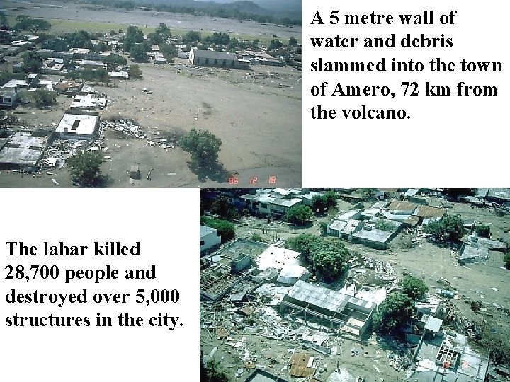
Lahars can be the most devastating outcome of many volcanoes. A relatively small eruption of Nevada del Ruiz, Columbia, in 1985, generated a lahar when the volcano melted a 2. 5 km 2 area of snow and ice. Water and debris rushed down the slopes, picking up more debris along the way.

A 5 metre wall of water and debris slammed into the town of Amero, 72 km from the volcano. The lahar killed 28, 700 people and destroyed over 5, 000 structures in the city.

Nuée ardentes destroy life and property in their paths. 60 people, thousands of animals and fish, and hundreds of acres of lumber were destroyed by ash flows from Mt. St. Helens. A Nuée Ardent killed 20, 000 people when Mt. Vesuvius exploded and shed a pyroclastic flow across the village of Pompeii in 79 AD.

People and animals died instantly from the rushing cloud of hot gas and ash.

Landslides can be generated when a volcano collapses during an eruption. During the Mt. St. Helens eruption 2. 3 km 3 of debris slid down the mountain at speeds up to 240 km/hr. The slide traveled over 24 km and left a 45 m deep deposit. 350, 000 years ago Mt. Shasta experienced a similar eruption and landslide that was 20 times greater than that of Mt. St. Helens.

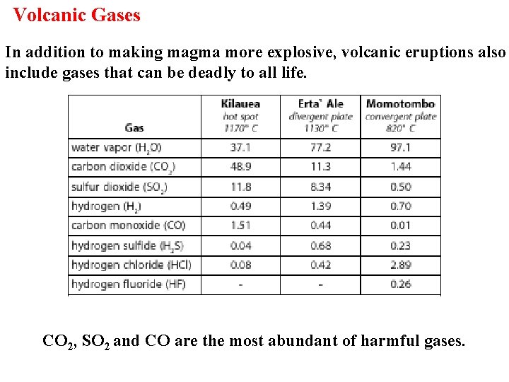
Volcanic Gases In addition to making magma more explosive, volcanic eruptions also include gases that can be deadly to all life. CO 2, SO 2 and CO are the most abundant of harmful gases.

SO 2 emissions can have direct effects on life in the vicinity of a volcano. An eruption in 1783 of Laki Crater (Iceland) produced a sulfurous haze that lasted for 9 months and killed 75% of all livestock and 24% of the Icelandic population. Volcanoes release more than 130 to 230 million tonnes of CO 2 into the atmosphere every year Humans add CO 2 at the rate of approximately 22 billion tonnes per year (150 times the rate of volcanic production) Human CO 2 production is equal to that if 17, 000 volcanoes like Kilauea were erupting every year.

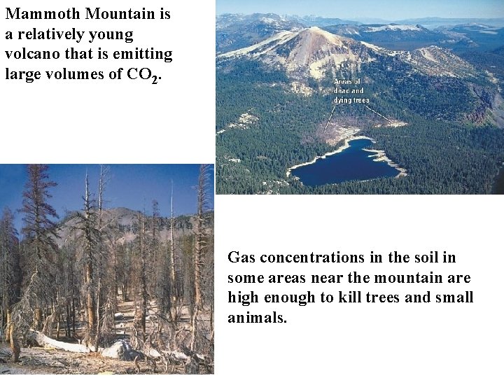
Mammoth Mountain is a relatively young volcano that is emitting large volumes of CO 2. Gas concentrations in the soil in some areas near the mountain are high enough to kill trees and small animals.

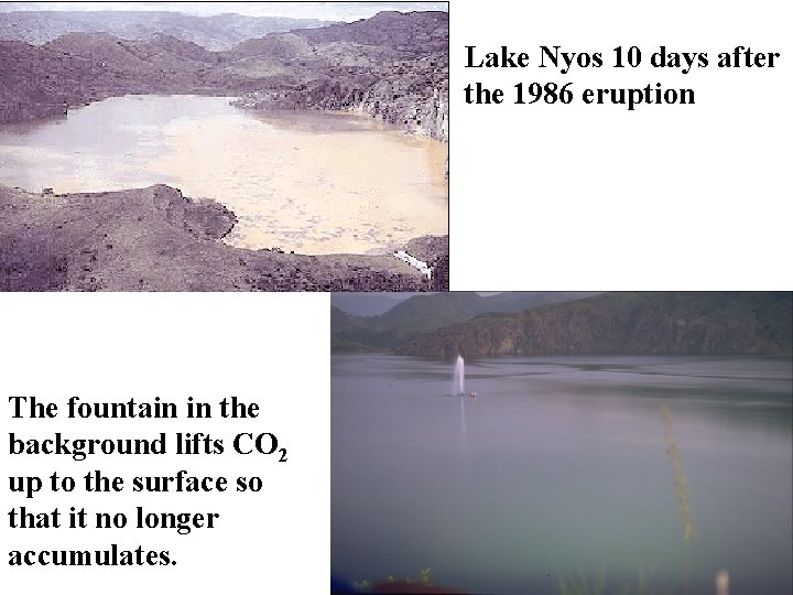
If the air that we breath has more than 10% CO 2 it becomes deadly because it displaces the Oxygen that we need for respiration. Lake Nios, Cameroon, is a very deep lake within a volcanic crater. The lake is so deep that hydrostatic pressure forces CO 2 to remain at the lake bottom. When the pressure of the CO 2 exceeds a certain limit the gas rapidly bubbles up out of the lake and flows as an invisible gas cloud down the adjacent slopes. On August 61, 1986 such a gas release flowed 19 km suffocating 1, 700 people along its route.

Lake Nyos 10 days after the 1986 eruption The fountain in the background lifts CO 2 up to the surface so that it no longer accumulates.

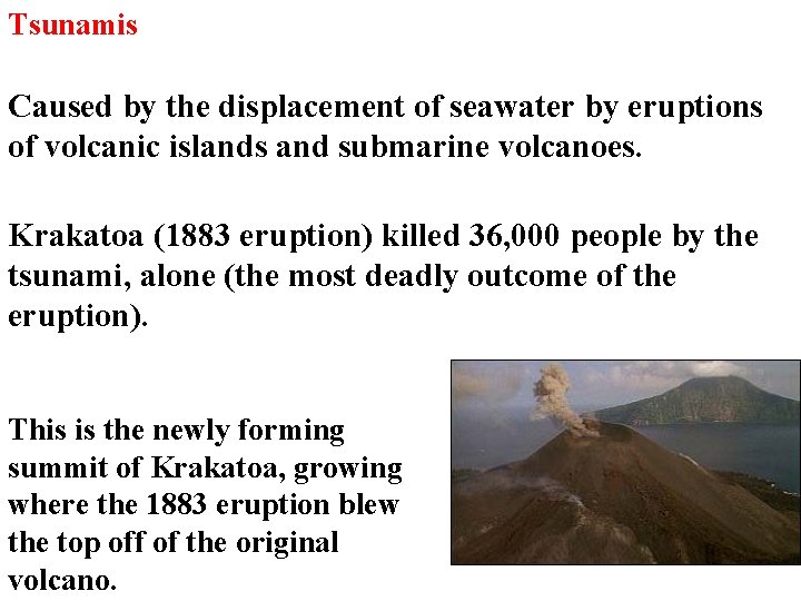
Tsunamis Caused by the displacement of seawater by eruptions of volcanic islands and submarine volcanoes. Krakatoa (1883 eruption) killed 36, 000 people by the tsunami, alone (the most deadly outcome of the eruption). This is the newly forming summit of Krakatoa, growing where the 1883 eruption blew the top off of the original volcano.

Global Climate Change Due to ash and gas that may spend years in the upper atmosphere; reduces incoming solar radiation. SO 2 from an eruption forms tiny droplets of sulfuric acid in the upper atmosphere. The droplets significantly increase global albedo…. . a negative radiative forcing that leads to cooling. Mt. Pinatubo (1991) released 22 million metric tons of SO 2 and reduced the Earth’s average temperature by 0. 5 degrees Celsius in the year following the eruption.

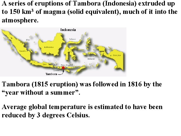
A series of eruptions of Tambora (Indonesia) extruded up to 150 km 3 of magma (solid equivalent), much of it into the atmosphere. Tambora (1815 eruption) was followed in 1816 by the “year without a summer”. Average global temperature is estimated to have been reduced by 3 degrees Celsius.

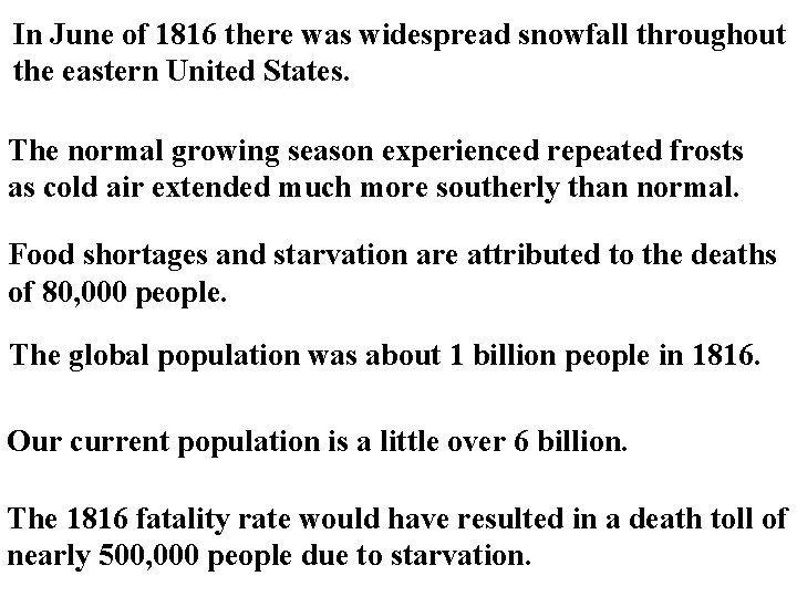
In June of 1816 there was widespread snowfall throughout the eastern United States. The normal growing season experienced repeated frosts as cold air extended much more southerly than normal. Food shortages and starvation are attributed to the deaths of 80, 000 people. The global population was about 1 billion people in 1816. Our current population is a little over 6 billion. The 1816 fatality rate would have resulted in a death toll of nearly 500, 000 people due to starvation.

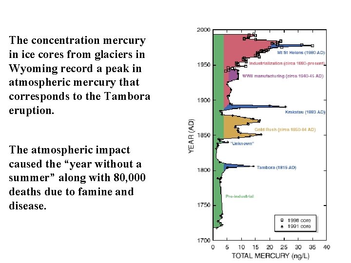
The concentration mercury in ice cores from glaciers in Wyoming record a peak in atmospheric mercury that corresponds to the Tambora eruption. The atmospheric impact caused the “year without a summer” along with 80, 000 deaths due to famine and disease.

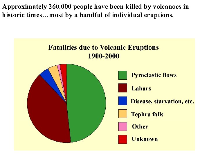
Approximately 260, 000 people have been killed by volcanoes in historic times…most by a handful of individual eruptions.

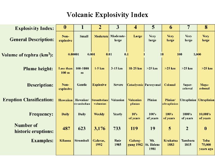
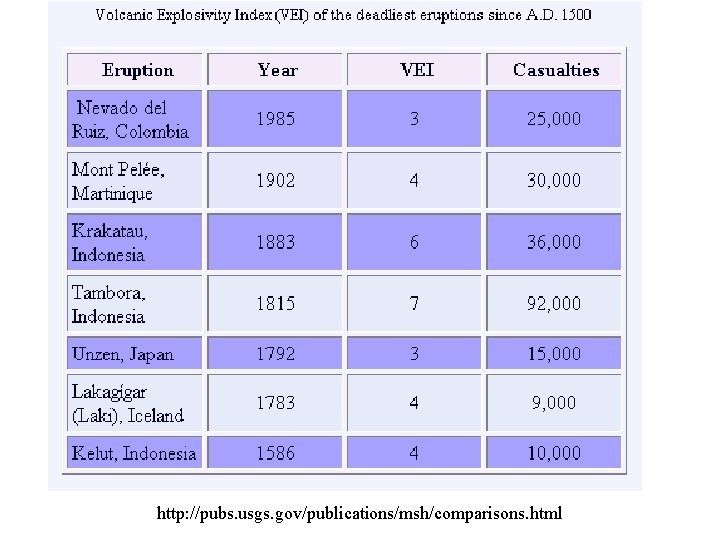
Volcanic Explosivity Index

http: //pubs. usgs. gov/publications/msh/comparisons. html

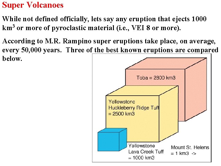
Super Volcanoes While not defined officially, lets say any eruption that ejects 1000 km 3 or more of pyroclastic material (i. e. , VEI 8 or more). According to M. R. Rampino super eruptions take place, on average, every 50, 000 years. Three of the best known eruptions are compared below.

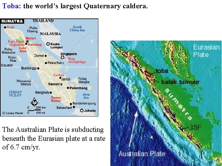
Toba: the world’s largest Quaternary caldera. The Australian Plate is subducting beneath the Eurasian plate at a rate of 6. 7 cm/yr.

Today Toba is a caldera or depression that is occupied by Lake Toba. It is 100 km long and 30 km wide. Toba last erupted about 75, 000 years ago with the largest eruption of the last 2 million years.

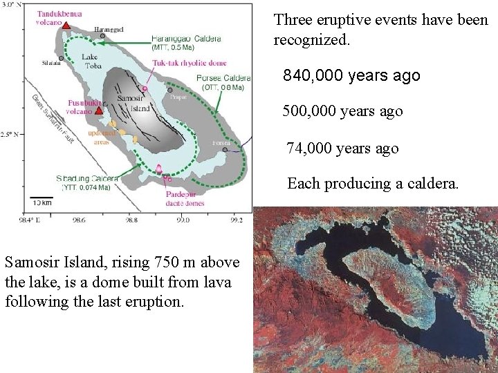
Three eruptive events have been recognized. 840, 000 years ago 500, 000 years ago 74, 000 years ago Each producing a caldera. Samosir Island, rising 750 m above the lake, is a dome built from lava following the last eruption.

The eruption ejected 2, 800 cubic km of material and the pyroclastic flows covered an area of at least 20, 000 square km. In the immediate vicinity of the volcano ash deposits reach 600 metres in thickness Ash fall from the eruption covers an area of at least 4 million square km; half the area of the continental United States. Global cooling is estimated at between 3 and 5 degrees Celsius with regional cooling of 15 degrees C. Tropical plant life would have been all but eliminated Temperate forests would loose 50% of all trees.

It is estimated that the growing population of homo sapiens (i. e. , us) was reduced from 100, 000 individuals to as few as 3, 000 individuals (97% of all humans were lost!). This reduction had been estimated for approximately the time of Toba’s eruption on the basis of genetic studies and is termed the “human population bottleneck”.

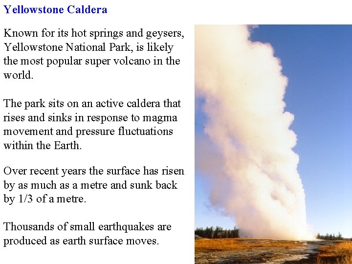
Yellowstone Caldera Known for its hot springs and geysers, Yellowstone National Park, is likely the most popular super volcano in the world. The park sits on an active caldera that rises and sinks in response to magma movement and pressure fluctuations within the Earth. Over recent years the surface has risen by as much as a metre and sunk back by 1/3 of a metre. Thousands of small earthquakes are produced as earth surface moves.

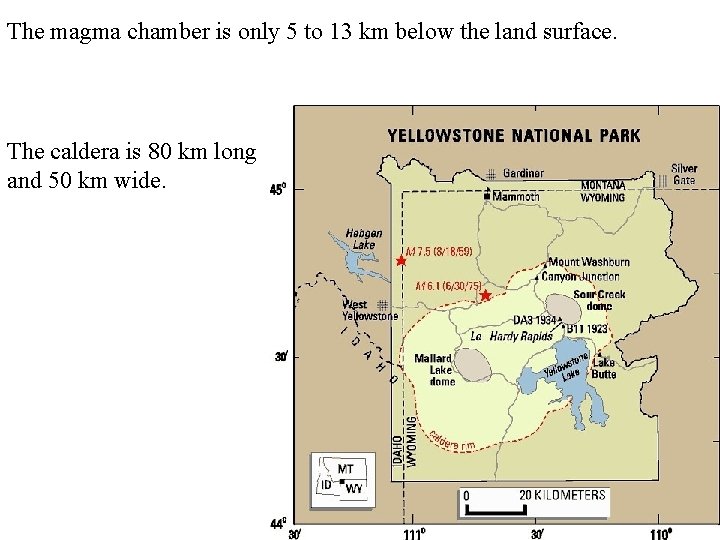
The magma chamber is only 5 to 13 km below the land surface. The caldera is 80 km long and 50 km wide.

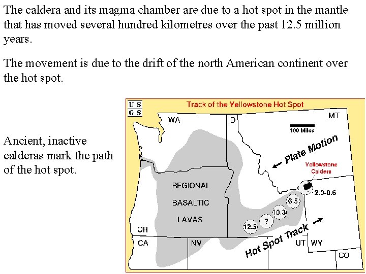
The caldera and its magma chamber are due to a hot spot in the mantle that has moved several hundred kilometres over the past 12. 5 million years. The movement is due to the drift of the north American continent over the hot spot. Ancient, inactive calderas mark the path of the hot spot.

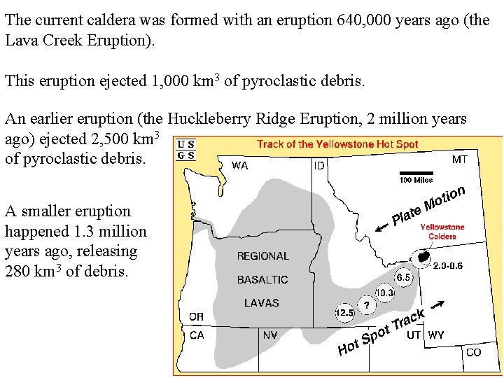
The current caldera was formed with an eruption 640, 000 years ago (the Lava Creek Eruption). This eruption ejected 1, 000 km 3 of pyroclastic debris. An earlier eruption (the Huckleberry Ridge Eruption, 2 million years ago) ejected 2, 500 km 3 of pyroclastic debris. A smaller eruption happened 1. 3 million years ago, releasing 280 km 3 of debris.

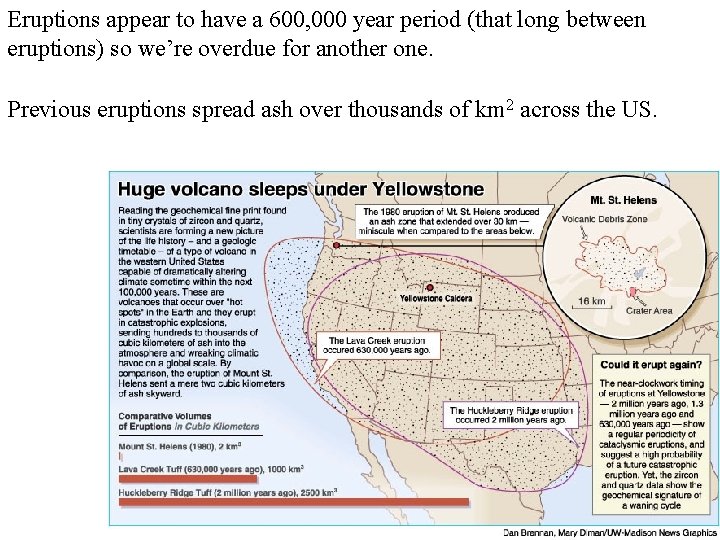
Eruptions appear to have a 600, 000 year period (that long between eruptions) so we’re overdue for another one. Previous eruptions spread ash over thousands of km 2 across the US.

Heightened monitoring of the Yellowstone Caldera in recent years has led to media concern of an impending eruption. Government officials and geologists indicate that there have been no clear indicators of high risk at this time. If such an eruption were to take place, North America and the rest of the world could experience another “Dark Ages”.
 Geology lecture series
 Lithosphere definition
 Types of volcanoes
 Magma chamber
 Types of volcanoes
 Seismology timeline
 Focal mechanism beach ball
 Orfeus seismology
 Seismology nepal
 Seismology
 Beach ball earthquake
 Two types of body waves
 Whats seismology
 Elements of seismology
 Seismology
 Gel geophysics
 Seismology
 01:640:244 lecture notes - lecture 15: plat, idah, farad
 Chapter 8 earthquakes and volcanoes
 Differentiate active and inactive volcanoes
 Constructive forces and destructive forces
 Steno's laws of stratigraphy
 Compressional stress
 What is extinction angle
 Types of folds geology
 Types of faults
 Volcano pictures for kids
 How are volcanoes classified
 Volcanoes for dummies
 Where do most volcanoes occur
 Extreme earth
 What do you already know about volcanoes?
 Guyots
 Volcanoes nature's incredible fireworks
 How are volcanoes formed
 Volcanic belts form along _____.
 Active volcanoes map
 Krakatau volcano
 Magma
Magma Volcanoes knowledge organiser
 What is elastic rebound theory?
 Ring of fire volcanoes
 Shield volcanoes
 Name volcanoes
 Where are volcanoes
 A'a hawaiian
 Volcanoes of italy map
 Financial engineering lecture notes
 Requirement analysis in software engineering notes
 Foundation engineering lecture notes
 Engineering ethics lecture notes
 Strike dip trend plunge
 Latvian environment, geology and meteorology centre
 Basin and range geology
 Lecture primaire
 Types of lecture method
 Forward engineering and reverse engineering
 What is geology
 Geology
 Geology what is
 Structural geology
 Grain size card
 3 types of differential stress
 Whats regolith
 Regolith geology
 Arizona state university geology
 Geology of cuba
 Confined and unconfined aquifer
 Maui elevation
 Thrust geology
 Uniformly dipping beds
 Mica hardness
 Gcse geology
 Structural geology
 Mohr diagram geology
 Geology earth science definition
 Geology earth science definition
 Zone of aeration
 Department of geology university of dhaka
 Chanel vidal
 Reverse fault
 Eduqas a level geology past papers
 Earth science vs geology
 Www.geology.sk
 Geology map of holderness coast
 Define physical geology
 Geology vocabulary
 Stereographic projection structural geology
 Conformable contact geology
 Prem model earth
 What are sediments?
 Geology definition
 Inorganic geology definition
 Disconformity definition geology
 Geology
 Forensic geology definition
 Rule of v's geology
 Unconformity
 Tension geology
 Joints geology
 Directions of cleavage
 James silvestro
 Hydrolysis weathering
 Geology
 Geology of cyprus
 5 themes of geology
 Polytypism geology
