GEL 2150 Field course and methodology in geology


 An Introduction to Geophysical Exploration.")


 is constant!")


")


")
")


- Slides: 80
GEL 2150 Field course and methodology in geology and geophysics Geophysical Methods
About this part of the course • Purpose: Introduction to geological/geophysical field methods used in hydrocarbon exploration • Working Plan: – Lecture: Introduction to the principles (27. 3) – Practical: • Introduction to excercise (29. 3, 14. 15 -14. 30) • Seismic Interpretation excercise (29. 3 14. 30 -17. 00 & 31. 3 13. 15 -16. 00) • Field course – Field based synthetic seismics (week 18) – Tectonics and sedimentation (week 20)
Lecture Contents • • Geophysical Methods Theory / Principles Acquisition and Prosessing Advantages and pitfalls
Geophysical methods • Passive: Method using the natural fields of the Earth, e. g. gravity and magnetic • Active: Method that requires the input of artificially generated energy, e. g. seismic reflection • The objective of geophysics is to locate or detect the presence of subsurface structures or bodies and determine their size, shape, depth, and physical properties (density, velocity, porosity…) + fluid content
Geophysical methods Method Measured parameter “Operative” physical property Application Gravity Spatial variations in the strength of the gravitational field of the Earth Density Fossil fuels Bulk mineral deposits Construction Magnetic Spatial variations in the strength of the geomagnetic field Magnetic susceptibility and remanence Fossil fuels Metalliferous mineral deposits Construction Seismic Travel times of reflected/refracted seismic waves Seismic velocity (and density) Fossil fuels Bulk mineral deposits Construction Electromagnetic (Sea. Bed Logging) Response to electromagnetic radiation Electric conductivity/resistivity and inductance Fossil fuels Metalliferous mineral deposits Electrical -Resistivity -Self potential Radar Widely used Earth resistance Electrical potentials Electrical conductivity Travel times of reflected radar pulses Dielectric constant Environmental Construction
Further reading • Keary, P. & Brooks, M. (1991) An Introduction to Geophysical Exploration. Blackwell Scientific Publications. • Mussett, A. E. & Khan, M. (2000) Looking into the Earth – An Introduction to Geological Geophysics. Cambridge University Press. http: //www. learninggeoscience. net/modules. php
Gravity • Gravity surveying measures spatial variations in the Earth’s gravitational field caused by differences in the density of sub-surface rocks • In fact, it measures the variation in the accelaration due to gravity • It is expressed in so called gravity anomalies (in milligal, 10 -5 ms-2), measured in respect to a reference level, usually the geoid • Gravity is a scalar
Gravity: Newton’s Law of Gravitation • Newton’s Universal Law of Gravitation for small masses, m 1 and m 2 separated by a distance r, at the earth surface: – With G (’big gee’) is the Universal Gravitational Constant: 6. 67 x 10 -11 m 3/kg 1·s 2 force m 1 r force m 2
Gravity: Earth • Spherical • Non-rotating • Homogeneous g (’little gee’) is constant!
Gravity • Non-spherical Ellipse of rotation • Rotating Centrifugal forces • Non-homogeneous – Subsurface heterogeneities – Lateral density differences in the Earth g (’little gee’) is NOT constant
Gravity units C P d = 100 m • An object dropped at C falls with a little greater acceleration than at P • Difference in acceleration can be measured: Dr = 0. 3 kg/m 3 r= 50 m • Here: dg = 1. 048· 10 -6 m/s 2 • Small values, therefore we measure gravity anomalies in milli. Gals (m. Gal), or gravity units, g. u. • 1 m. Gal = 10 g. u. = 10 -5 m/s 2 ~ 10 -6·g
Gravity anomalies The Gravity anomaly is positive if the body is more dense than its surroundings, negative if less Gravity is a scalar: the combined pull has approx. The same direction as the Earth pull; we measure therefore only the size, or magnitude, of g
Gravity anomalies of specific bodies
Gravity anomalies of specific bodies
Measurements of Gravity • Spring or Beam • Corrections m extension m m·g m·(g+dg) – Instrumental drift – Latitude (due to Earth rotation) – Elevation • Free-air correction • Bouguer correction • Terrain correction – Tidal – Eötvös (due to measurements on moving vehicles)
NGU, 1992
Magnetics • Magnetic surveying aims to investigate the subsurface geology by measuring the strength or intensity of the Earth’s magnetic field. • Lateral variation in magnetic susceptibility and remanence give rise to spatial variations in the magnetic field • It is expressed in so called magnetic anomalies, i. e. deviations from the Earth’s magnetic field. • The unit of measurement is the tesla (T) which is volts·s·m-2 In magnetic surveying the nanotesla is used (1 n. T = 10 -9 T) • The magnetic field is a vector • Natural magnetic elements: iron, cobalt, nickel, gadolinium • Ferromagnetic minerals: magnetite, ilmenite, hematite, pyrrhotite
NGU, 1992
Electromagnetics Electromagnetic methods use the response of the ground to the propagation of incident alternating electromagnetic waves, made up of two orthogonal vector components, an electrical intensity (E) and a magnetizing force (H) in a plane perpendicular to the direction of travel
Electromagnetics Transmitter Primary field Receiver Secondary field Conductor Electromagnetic anomaly = Primary Field – Secondary Field
Electromagnetics – Sea Bed Logging SBL is a marine electromagnetic method that has the ability to map the subsurface resistivity remotely from the seafloor. The basis of SBL is the use of a mobile horizontal electric dipole (HED) source transmitting a low frequency electromagnetic signal and an array of seafloor electric field receivers. A hydrocarbon filled reservoir will typically have high resistivity compared with shale and a water filled reservoirs. SBL therefore has the unique potential of distinguishing between a hydrocarbon filled and a water filled reservoir
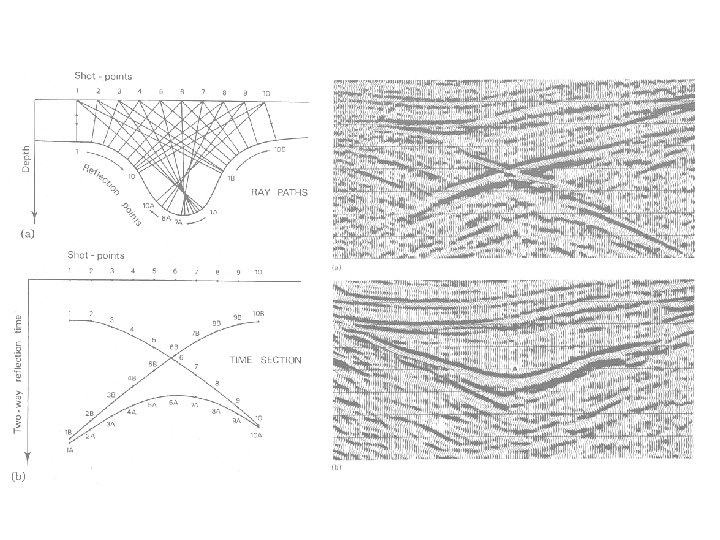
Reflection Seismology • Principle of reflection seismology – – What is reflection seismology Seismic wave propagation Acquisition – collecting seismic data Prosessing • Limitations and Pitfalls – Resolution (Horizontal and Vertical) – Velocity Effects (Seismic velocities – Depth Conversion – Geometrical Effects (Migration) – Seismic Modelling (Synthetic seismograms) • 2 D vs. 3 D seismic reflection
Reflection Seismology
Reflection Seismology
Reflection Seismology
Reflection Seismology • Spherical spreading • Absorption • Transmission/conversion
Reflection Seismology Incident ray Amplitude: A 0 Reflected ray Amplitude: A 1 Layer 1 , v 1 Layer 2 , v 2 ¹ r 1 , v 1 Acoustic Impedance: Z = r·v Reflection Coefficient: R = A 1/A 0 Transmission Coefficient: T = A 2/A 0 Transmitted ray Amplitude: A 2 -1 ≤ R ≤ 1 R = 0 All incident energy transmitted (Z 1=Z 2) no reflection R = -1 or +1 All incident energy reflected strong reflection R < 0 Phase change (180°) in reflected wave
Reflection Seismology
Reflection Seismology
Reflection Seismology
Reflection Seismology • Shotpoint interval 60 seconds • 25 -120 receivers • Sampling rate 4 milliseconds • Normal seismic line ca. 8 s. TWT
Reflection Seismology
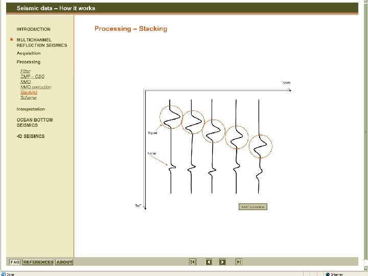
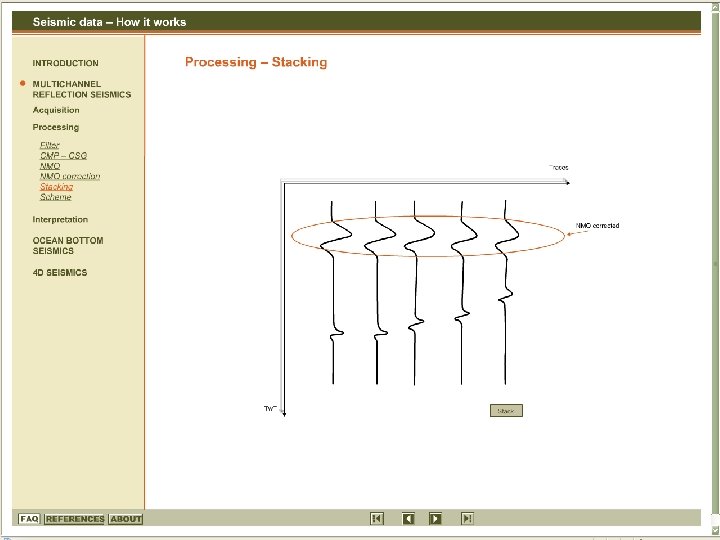
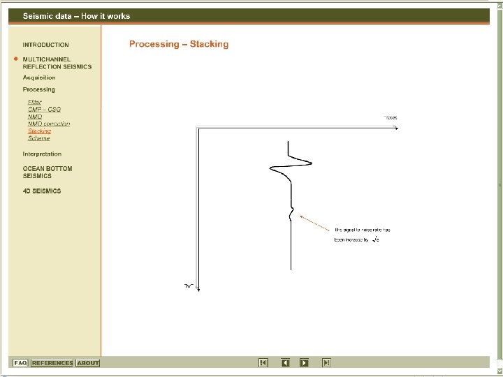
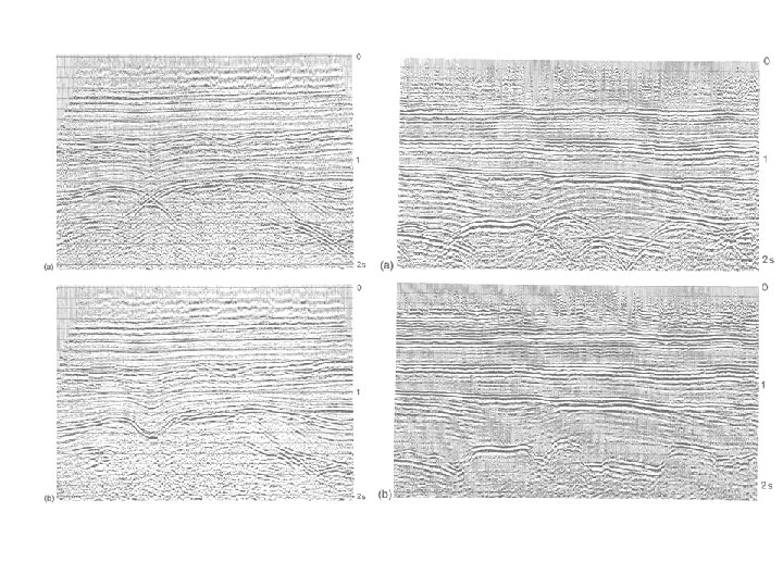
Reflection Seismology • SEISMIC PROSESSING – The objective of seismic prosessing is to enhance the signal-to-noise ration by means of e. g. filtering
Reflection Seismology • Limitations and Pitfalls – Interference – Horizontal and Vertical Resolution – Velocity Effects – Geometrical Effects – Multiples
INTERFERENCE
Reflection Seismology Interference
Reflection Seismology Interference
VERTICAL RESOLUTION
Reflection Seismology 100 Hz Wavelength increases with depth Frequency decreases 67 Hz Reduced vertical resolution 40 Hz v l 100 Hz 2 km/s 20 m 5 m ~250 m 40 Hz 4 km/s 100 m 25 m ~2250 m f l/4 z
Reflection Seismology (Brown 1999)
Reflection Seismology (Brown 1999)
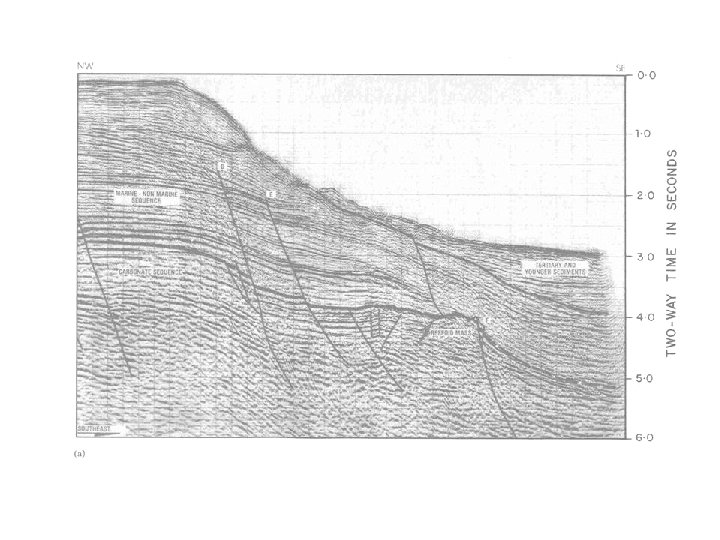
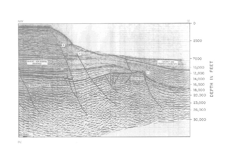
Reflection Seismology
HORIZONTAL RESOLUTION
Reflection Seismology
Reflection Seismology ~690 m ~2500 m ~25 m
Reflection Seismology
Reflection Seismology
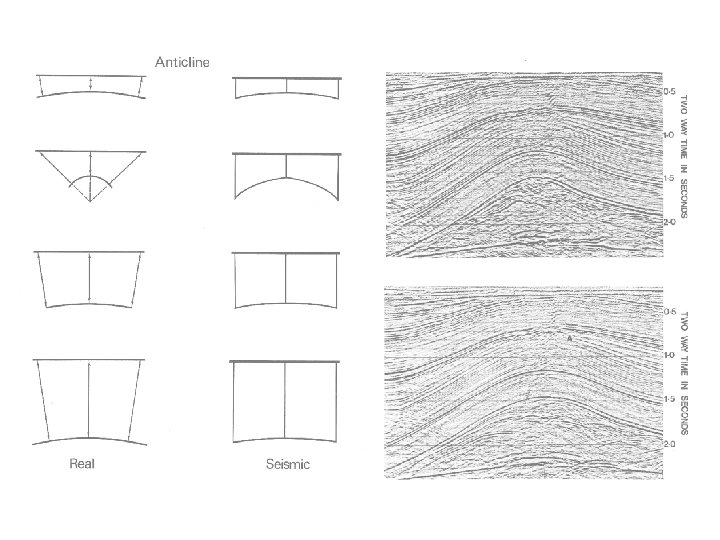
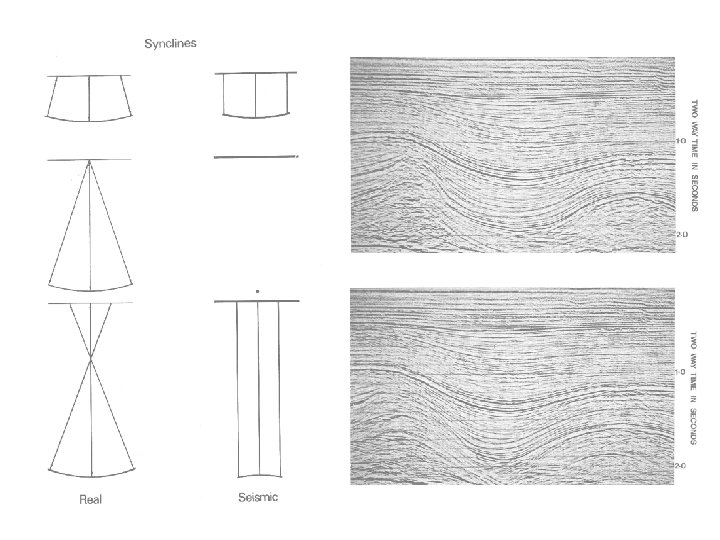
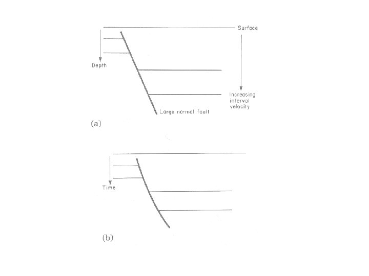
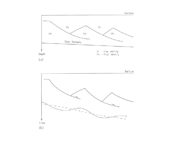
GEOMETRICAL EFFECTS
Reflection Seismology
Reflection Seismology
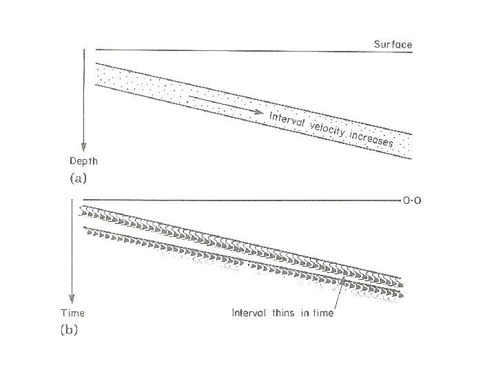
VELOCITY EFFECTS
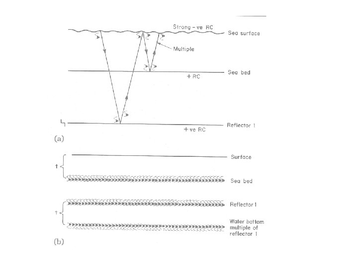
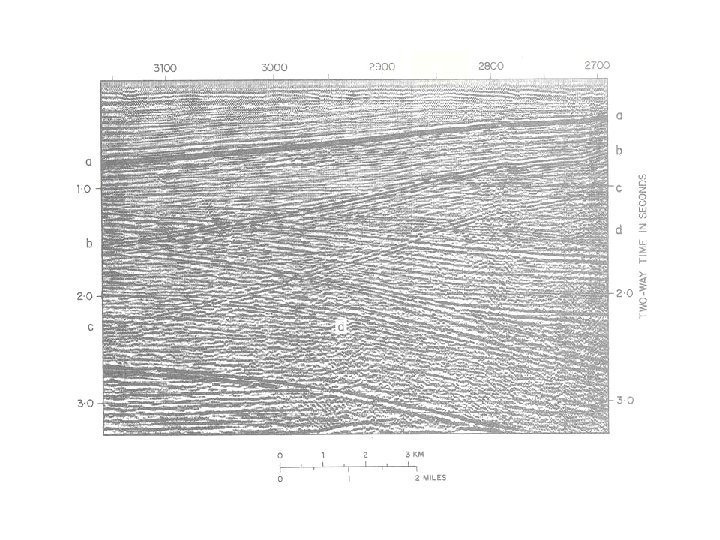
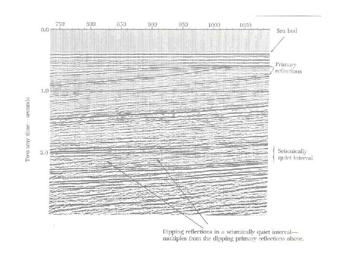
MULTIPLES
Magnetics • Magnetic susceptibility • Sedimentary Rocks – Limestone: 10 -25. 000 – Sandstone: 0 -21. 000 – Shale: 60 -18. 600 a dimensionless property which in • Igneous Rocks essence is a – Granite: 10 -65 measure of how – Peridotite: 95. 500 -196. 000 susceptible a material is to becoming • Minerals magnetized – Quartz: -15 – Magnetite: 70. 000 -2 x 10⁷
Magnetics • Induced and remanent magnetization • Intensity of magnetization, J • Magnetic anomaly = regional - residual H Ji Jres Jr