Volcanic Landforms How do volcanoes change the Earths


 of Shiprock, a volcanic neck, in the distance. Photo")


 show the immense extent of Venus's")


- Slides: 47
Volcanic Landforms How do volcanoes change the Earth’s surface?
What you will learn 1. What landforms lava and ash create. 2. How the magma that hardens beneath Earth’s surface creates landforms. 3. Other distinct features that occur in volcanic areas.
Landforms from lava and ash • • Shield volcanoes Cindercone volcanoes Composite volcanoes Lava plateaus
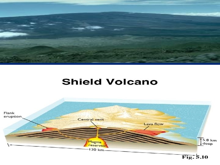
Shield Volcano *Lava* • Thin layers of lava cool on top of one another • A wide, gently sloping mountain forms gradually over time • Example: Hawaiian volcanoes
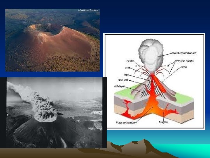
Cinder Cone Volcano *Lava* • Steep, cone-shaped hill or mountain • Thick lava (high viscosity) builds up in cone producing ash, cinders, and bombs which pile up around vent after it explodes • Example: Sunset Crater in Arizona
Cinders and Bombs
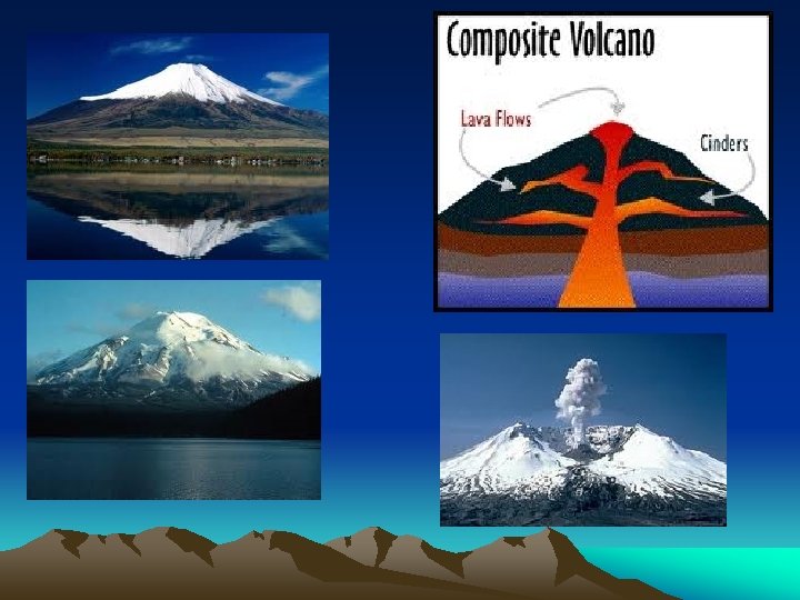
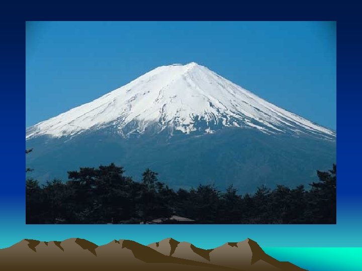
Composite Volcano *Lava* • Tall, cone-shaped mountains in which layers of lava alternate with layer of ash • Lava flows alternate with explosions • i. e. Stratavolcano • Example: Mount Fuji in Japan and Mount St. Helens in Washington state
Quick Check • • What are the 3 types of volcanoes? What are the shapes of each? Which are explosive and which are not? Which ones have lava?
Krakatau Explosion 1883 • http: //dsc. discovery. com/tv-shows/othershows/videos/krakatoa-volcano-ofdestruction-loudest-explosion-ever. htm
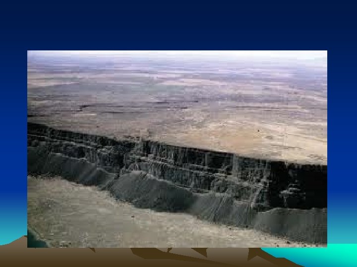
Lava Plateau *Lava* • Thin, runny lava flows out of several long cracks in an area • The lava travels far before cooling and solidifying • Lava flood layers upon lava flood until a raised plateau is formed over millions of years • Example: Columbia Plateau in Washington, Oregon, Idaho
Caldera *Lava* Huge hole caused by the volcano collapsing after explosive eruption empties magma chamber Crater Lake in Oregon, Mount Mazama Over time, ash breaks down and releases potassium and phosphorus that plants need. It results in fertile soil.
Volcanic Neck *Magma* • Magma hardens in volcano’s pipe, soft rock wears away exposing solid magma • Looks like giant tooth
Dike *Magma* • Magma that forces itself across rock layers and hardens • Underground, horizontal channels or tubes • Broadens coasts of Hawaiian islands
Sill *Magma* Magma squeezes between horizontal layers and hardens Magma hardens ACROSS the layers.
Quick Check • What is a caldera? • What way does a dike go, horizontally or vertically? • Which way does a sill go?
Batholith *Magma* Mass of rock formed when magma chamber cools inside crust Rough, jagged texture after weathering and erosion of land above batholith Ex: Half Dome in Yosemite National Park
Dome Mountain *Magma* Formed by small bodies of hardened magma which are forced upwards into dome shape
Geothermal Activity • Magma a few km beneath earth’s surface heats underground water. • Hot Springs- When groundwater is heated by a nearby body of magma or by a hot rock deep underground. • The hot water rises to the surface and collects in a natural pool.
Geysers • When rising hot water and steam become trapped underground in a narrow crack. • Pressure builds until the mixture suddenly sprays above the surface. • A fountain of water and steam that erupts from the ground is a geyser.
Geothermal Energy • Water heated by magma can be used as a source of electricity. • Steam from underground is piped into turbines and spins a wheel. • The moving wheel in the turbine turns a generator that changes the energy of motion into electrical energy. • California, New Zealand use it as electricity and Reykjavik, Iceland use this to heat their homes.
Quick Check • What’s the difference between a hot spring and a geyser?
Can you guess the type of landform?
Indian Head Mountain, Montana
Laccolith at Fresno Canyon, north of Lajitas. Big Bend National Park, Texas. Photo credit: USGS Digital Data Series DDS-21 CD-ROM
Photograph by J. D. Griggs on 16 July 1990
Before the eruption After the eruption
“Magma Boulders” photo by Tibi Marin
John Day region in Oregon
Devil's Tower, WY http: //www. nps. gov/deto/faqs. htm Shiprock, New Mexico
United States India
Mount Aso vents a large cloud of steam at Japan's Aso National Park.
Belknap Volcano, Oregon USGS Photograph taken on October 1, 1984, by Lyn Topinka
Sill can be seen as the dark layer of rock to the left of the snow field. Glacier National Park. Photo credit: USGS Digital Data Series DDS-21 CD-ROM
Dike on south side (left) of Shiprock, a volcanic neck, in the distance. Photo credit: USGS Digital Data Series DDS-21 CD-ROM
Pu`u `O`o Eruption on Flanks of Kilauea, Hawaii Photograph by C. Heliker on 2 June 1986
Olympus Mons: One hundred times larger than Mauna Loa
The Moon Many craters on Earth’s moon were believed to be filled by lava flows.
Venus This picture (mapped via radar in 1994) show the immense extent of Venus's volcanism. She has more in the way of lava flows than the Earth has rivers. Copyright © Dr B. M. Gunn 1998 -2003
Volcanoes on Io This image shows what it might look like standing on the surface of Jupiter's moon, Io. A smoldering volcano can be seen against the large image of Jupiter. Smoke added with Photoshop. Background image of Jupiter is a Cassini spacecraft image taken in 2001 while flying by Jupiter on its way to Saturn (Credit: NASA/JPL/University of Arizona).
Triton: Neptune's Largest Moon Credit: Voyager 2, NASA The above picture of Triton was taken in 1989 by the only spacecraft ever to pass Triton: Voyager 2 found fascinating terrain, a thin atmosphere, and even evidence for ice volcanoes on this world of peculiar orbit and spin.
Geysers on Triton Credit: NASA, Voyager Project, Copyright Calvin J. Hamilton Frozen, Solid Nitrogen!!! Explanation: In August of 1989 NASA's Voyager 2 spacecraft passed by Neptune, the most distant of the solar system's gas giant planets. Its encounter with Neptune climaxed with its closest approach to Neptune's largest moon Triton. From a distance of about 24, 000 miles the robot space probe surveyed Triton's surface, whose temperature averages nearly -400 degrees Fahrenheit (-240 degrees C), and discovered surprising evidence of a complex and active world. For example, the prominent dark streaks in this image seem to come from small volcanoes and may consist of nitrogen frost mixed with organic compounds ejected during geyser-like eruptions.
Image Credits • • • • • Belknap 84_belknap_shield_volcano_10 -01 -84. jpg Belknap Shield Volcano, Oregon. View from Mc. Kenzie Pass. USGS Photograph taken on October 1, 1984, by Lyn Topinka. http: //images. google. com/imgres? imgurl=http: //vulcan. wr. usgs. gov/Imgs/Jpg/Belknap/Images/Belknap 84_belknap_shield_volcano_10 -0184_med. jpg&imgrefurl=http: //vulcan. wr. usgs. gov/Volcanoes/Belknap/Locale/framework. html&h=412&w=600&sz=86&hl=en&start=1&um=1&tbnid=QL 62 p. JIDk. Hz 1 ZM: &tbnh=93&tbn w=135&prev=/images%3 Fq%3 Dshield%2 Bvolcano%26 svnum%3 D 10%26 um%3 D 1%26 hl%3 Den%26 client%3 Dfirefox-a%26 rls%3 Dorg. mozilla: en-US: official%26 sa%3 DN http: //images. google. com/imgres? imgurl=http: //volcanoes. usgs. gov/Imgs/Jpg/Kilauea/32512553023_large. jpg&imgrefurl=http: //volcanoes. usgs. gov/Products/Pglossary/Spat. Cin. Cone. html&h=500&w=800&sz=65&tbnid=yh 2 fxh 2 p 2 g. CTc. M: &tbnh=89&tbnw=143&prev=/images%3 Fq %3 Dcinder%2 Bcone%26 um%3 D 1&start=2&sa=X&oi=images&ct=image&cd=2 http: //volcanoes. usgs. gov/Products/Pglossary/aa. html http: //volcanoes. usgs. gov/Products/Pglossary/pahoehoe. html http: //images. google. com/imgres? imgurl=http: //www. fas. org/irp/imint/docs/rst/Sect 17/Deccan. Local. JPG&imgrefurl=http: //www. fas. org/irp/imint/docs/rst/Sect 17_3. html&h=239&w =350&sz=36&hl=en&start=15&um=1&tbnid=W 8 gf. Ll. Id. Boo. Rc. M: &tbnh=82&tbnw=120&prev=/images%3 Fq%3 DDeccan%2 BPlateau%26 svnum%3 D 10%26 um%3 D 1%26 hl%3 Den%26 cl ient%3 Dfirefox-a%26 rls%3 Dorg. mozilla: en-US: official%26 sa%3 DN http: //images. google. com/imgres? imgurl=http: //www. pbs. org/wgbh/nova/volcano/images/anat_caldera. jpg&imgrefurl=http: //www. pbs. org/wgbh/nova/volcano/anat_07. html&h=418&w=48 8&sz=25&hl=en&start=12&um=1&tbnid=YBOFtx. OM 0 Jwnt. M: &tbnh=111&tbnw=130&prev=/images%3 Fq%3 DCaldera%26 svnum%3 D 10%26 um%3 D 1%26 hl%3 Den%26 client%3 Dfiref ox-a%26 rls%3 Dorg. mozilla: en-US: official%26 sa%3 DN http: //images. google. com/imgres? imgurl=http: //cache. eb. com/eb/image%3 Fid%3 D 75503%26 rend. Type. Id%3 D 4&imgrefurl=http: //www. britannica. com/eb/art/print%3 Fid%3 D 71635&h=360&w=550&sz=15&hl=en&start=1&um=1&tbnid=1 ima. B 1 B 8 i 8 i. Wm. M: &tbnh=87&tbnw=133&prev=/images%3 Fq%3 DMount%2 BFuji%26 svnum%3 D 10%26 um %3 D 1%26 hl%3 Den%26 client%3 Dfirefox-a%26 rls%3 Dorg. mozilla: en-US: official%26 sa%3 DG http: //www. olywa. net/radu/valerie/St. Helens. html http: //www. uwsp. edu/geo/faculty/ritter/glossary/v_z/volcanic_neck. html http: //images. google. com/imgres? imgurl=http: //geoinfo. nmt. edu/staff/scholle/graphics/tourist/Shiprock. jpg&imgrefurl=http: //geoinfo. nmt. edu/staff/scholle/graphics/tourist/shi prock 1. html&h=500&w=341&sz=55&hl=en&start=11&um=1&tbnid=8 v 3 pr. Dlo. SJ 1 rp. M: &tbnh=130&tbnw=89&prev=/images%3 Fq%3 DVolcanic%2 Bneck%26 svnum%3 D 10% 26 um%3 D 1%26 hl%3 Den%26 client%3 Dfirefox-a%26 rls%3 Dorg. mozilla: en-US: official%26 sa%3 DN http: //images. google. com/imgres? imgurl=http: //www. bigskycachers. com/indianhead_1. jpg&imgrefurl=http: //www. bigskycachers. com/indianhead. htm&h=188&w=251&sz=1 5&hl=en&start=12&um=1&tbnid=e. Fv 1 EMCCZZfo. M: &tbnh=83&tbnw=111&prev=/images%3 Fq%3 DDome%2 Bmountain%26 svnum%3 D 10%26 um%3 D 1%26 hl%3 Den%26 client%3 Dfirefoxa%26 rls%3 Dorg. mozilla: en-US: official%26 sa%3 DN http: //serc. carleton. edu/images/NAGTWorkshops/health 04/Boulder. Batholith. jpg http: //images. google. com/imgres? imgurl=http: //www. uwsp. edu/geo/faculty/ritter/images/lithosphere/dikes_large. jpg&imgrefurl=http: //www. uwsp. edu/geo/faculty/ritter/geog 1 01/uwsp_lectures/lecture_igneous_rocks. html&h=462&w=704&sz=101&hl=en&start=17&um=1&tbnid=st 2 RBnpchn 7 e. M: &tbnh=92&tbnw=140&prev=/images%3 Fq%3 DDike%2 Bvolcanic%2 Blandform%26 svnum%3 D 10%26 um%3 D 1%26 hl%3 Den%26 client%3 Dfirefoxa%26 rls%3 Dorg. mozilla: en-US: official%26 sa%3 DN http: //images. google. com/imgres? imgurl=http: //z. about. com/d/space/1/7/q/0/1/olympus. jpg&imgrefurl=http: //space. about. com/od/mars/ig/Mars-Pictures-Gallery/Shield. Volcano. htm&h=462&w=499&sz=40&hl=en&start=13&um=1&tbnid=RKqh. DYPMx. Wqi. AM: &tbnh=120&tbnw=130&prev=/images%3 Fq%3 DShield%2 Bvolcano%26 svnum% 3 D 10%26 um%3 D 1%26 hl%3 Den%26 client%3 Dfirefox-a%26 channel%3 Ds%26 rls%3 Dorg. mozilla: en-US: official%26 sa%3 DN http: //images. google. com/imgres? imgurl=http: //www. windows. ucar. edu/moon/images/luna. gif&imgrefurl=http: //www. windows. ucar. edu/tour/link%3 D/moon/images/luna_im age. html%26 edu%3 Delem&h=477&w=597&sz=104&hl=en&start=2&um=1&tbnid=Aa 8 xk 6 F 0 vkvo. M: &tbnh=108&tbnw=135&prev=/images%3 Fq%3 Dlava%2 Bflows%2 Bon%2 BEarth%2527 s%2 Bmoon%26 svnum%3 D 10%26 um%3 D 1%26 hl%3 Den%26 client%3 Dfirefo x-a%26 rls%3 Dorg. mozilla: en-US: official%26 sa%3 DN http: //images. google. com/imgres? imgurl=http: //www. geokem. com/images/pix/venus-viaradar. jpg&imgrefurl=http: //www. geokem. com/venusian. html&h=300&w=300&sz=29&hl=en&start=15&um=1&tbnid=W 5 TVi. RCz. YXn 1 M: &tbnh=116&tbnw=116&prev=/images%3 Fq%3 Dlava%2 Bflows%2 Bon%2 BEarth%2527 s%2 Bmoon%26 svnum%3 D 10%26 um%3 D 1%26 hl%3 Den%26 client%3 Dfirefoxa%26 rls%3 Dorg. mozilla: en-US: official%26 sa%3 DN http: //images. google. com/imgres? imgurl=http: //members. wri. com/jeffb/vistapro/iojupiter. jpg&imgrefurl=http: //members. wri. com/jeffb/vistapro/&h=768&w=1024&sz=120&hl=en&start=5&um=1&tbnid=s. Utfh. D 5 gia 5 YAM: &tbnh=113&tbnw=150&prev=/image s%3 Fq%3 DIo%2 Bmoon%2 Bof%2 Bjupiter%26 svnum%3 D 10%26 um%3 D 1%26 hl%3 Den%26 client%3 Dfirefox-a%26 rls%3 Dorg. mozilla: en-US: official%26 sa%3 DG http: //images. google. com/imgres? imgurl=http: //apod. nasa. gov/apod/image/9910/triton 2_vg 2. jpg&imgrefurl=http: //apod. nasa. gov/apod/ap 991010. html&h=493&w=400&sz= 40&hl=en&start=13&um=1&tbnid=GMTR 0 c 0 W 4 Neq. M: &tbnh=130&tbnw=105&prev=/images%3 Fq%3 DTriton%2 Bmoon%2 Bof%2 Bneptune%26 svnum%3 D 10%26 um%3 D 1%26 hl%3 Den%26 client%3 Dfirefoxa%26 rls%3 Dorg. mozilla: en-US: official%26 sa%3 DG