GALOCAD GAlileo LOcal Component for nowcasting and forecasting


 Royal Observatory of Belgium Involved in research on GNSS since 1988 for")
 Geophysical Institute of the Bulgarian Academy of Sciences Involved in ionosphere and")
 The effect of the atmosphere on GNSS signal propagation")
 Mitigation models often provide a 95% error ellipse but")


 - Measure positions in real-time with a few")
 The RTK technique measures the baseline between the reference station (A)")
 j i A B contains the unknows, the receiver B coordinates")
 Detection of small-scale structures using a «one")
 Two types")

")
")


 Effects of these structures on relative (or differential) positioning")
 Quiet iono Medium amplitude")

 Double differences are corrected for the computed")
")
")
")

- Slides: 28
GALOCAD GAlileo LOcal Component for nowcasting and forecasting Atmospheric Disturbances R. Warnant, G. Wautelet, S. Lejeune, H. Brenot, J. Spits, S. Stankov Royal Meteorological Institute Brussels (Belgium)
Framework Selected in the frame of call for proposal issued by GSA (GNSS Supervising Authority) Consortium of 3 Institutes (now 2) Coordinator R. Warnant Project duration: November 2006 – July 2008
Consortium (1/2) Royal Observatory of Belgium Involved in research on GNSS since 1988 for high accuracy applications in Geophysics Develops models for the mitigation of atmospheric effects on GNSS Royal Meteorological Institute of Belgium Involved in the monitoring of ionospheric and geomagnetic activity at the Geophysical centre of Dourbes since the fifties.
Consortium (2/2) Geophysical Institute of the Bulgarian Academy of Sciences Involved in ionosphere and geomagnetic activity modelling and forecasting
Background of the project (1/2) The effect of the atmosphere on GNSS signal propagation remains one of the main error sources for many positioning techniques In particular, local irregular structures in the ionosphere Total Electron Content or in the neutral atmosphere water vapour can strongly degrade the ambiguity resolution process for high accuracy (cm-level) applications
Background of the project (2/2) Mitigation models often provide a 95% error ellipse but what happens for the other 5% ? This is a limitation to the reliability of future Galileo services which are supposed to provide certifed accuracy levels
Objectives Research in order to develop a prototype Galileo Local Component for the monitoring of Galileo «integrity» with respect to atmospheric threats (first, in Belgium) : nowcasting : to inform users (in real time) about the atmosphere influence on their applications (can Galileo certified accuracy be reached ? ) forecasting : to forecast a few hours in advance the occurrence of ionospheric disturbances which could degrade significantly Galileo accuracy
Nowcasting the effet of ionospheric disturbances on precise positioning Detection and characterization of irregular structures in the ionosphere which can degrade GNSS accuracy based on a dense network of GNSS stations (70 stations in Belgium) Assessment of the effect of these atmospheric structures on GNSS high accuracy applications
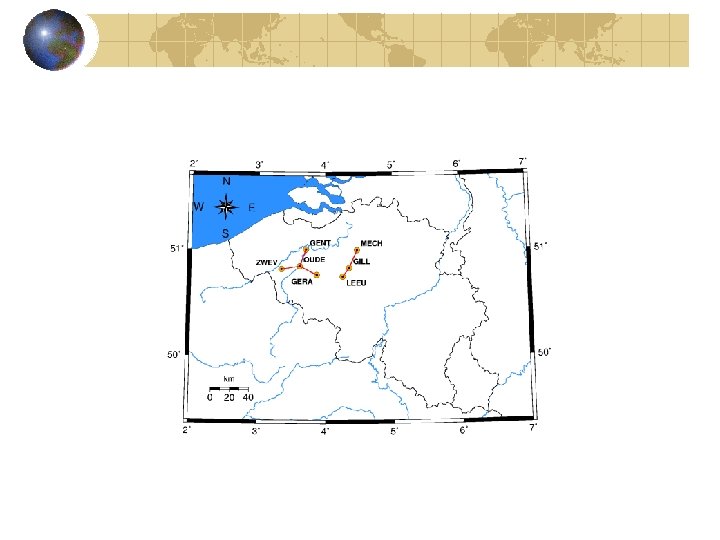
Belgian dense network - This network is one of the densest permanent networks in Europe: baseline lengths range between 4 km and about 30 km. - All the stations have positions who are precisely known.
Principle of Real Time Kinematic (RTK) - Measure positions in real-time with a few centimeter accuracy - The users combine their own phase measurements with the measurements made by a reference station of which the position is precisely known A REFERENCE STATION with a known position B 10 -20 km RTK USER with an unknown position - The distance between the user and the reference station should not be larger than 10 - 20 km mainly depending on ionospheric activity.
Double differences (1/2) The RTK technique measures the baseline between the reference station (A) and the mobile user (B) by forming double differences of phase measurements. j i A B - In the double differences, all the error sources which are common to the phase measurements performed by receivers A and B cancel, in particular, satellite and receiver clock errors orbit errors.
Doubles differences (2/2) j i A B contains the unknows, the receiver B coordinates or more exactly the 3 components of the baseline vector. The integer to resolve for knowing the precise position of the user (B).
Small-scale structures in the ionosphere (step 1) Detection of small-scale structures using a «one station method» High frequency changes in the geometric free combination of GPS dual frequency measurements are monitored Detection of small-scale structures in TEC
Small-scale structures in ionosphere Method applied to Brussels GPS data (1993 now) Two types of structures detected : Travelling Ionosphere Disturbances Noise-like structures
Travelling Ionospheric Disturbances
Noise-like structures (1/2)
Noise-like structures (2/2)
Climatology of iono disturbances
Climatology of iono disturbances
Differential ionospheric effects (step 2) Effects of these structures on relative (or differential) positioning depend on gradients in space (not in time) The term is computed to assess the « differential » effects.
Effects of TID’s on DD of L 1 (20 km) Quiet iono Medium amplitude TID Large amplitude TID
Effects of an extreme geomagnetic storm November 20 2003 Storm
Assessment of the positioning error (step 3) Double differences are corrected for the computed term Then the difference between the positions computed based on uncorreted DD and DD corrected for the ionosphere assesses the influence of the ionosphere on positions
Effects on positions (quiet ionosphere)
Effects on positions (strong TID)
Effects on positions (extreme storm)
Conclusions First attempts in order to build a Galileo Local Component for nowcasting the effects of ionospheric threats have been presented. Same kind of work has been done for the neutral atmosphere (effects of strong thunderstorms, heavy rainfalls, …) Method will be soon implemented in real time for further validation (in collaboration with field users)