SISTEM ALAM SEMESTA Titi Arneth Arlene Aaron Zadrach


 dan")


 MEMISAH DIRI Peta Interaksi Lempeng BERPAPASAN")
 Studi mekanisme fokus gempa")


")

 mekanisme batas lempeng • Jelaskan secara")


 satellite")


 Jaringan GPS Copyright: Irwanm@gd. itb. ac. id")

 : 18, Thailand (Game-T) : 3, Indonesia (Sugar+FORSGC+IGS)")


")


- Slides: 39
SISTEM ALAM SEMESTA
Titi Arneth Arlene Aaron Zadrach
Plate Tectonics: A Unifying View of Earth
Komposisi Bumi • Kerak • Mantel • Inti Dimention 8
Kerak Bumi -Kerak benua : ketebalan mencapai 100 km komposisi granitis; Si & Al bersifat getas berat jenis lebih kecil. -Kerak samudera : ketebalan : 8 -10 km komposisi : basaltis; Si & Mg bersifat lentur, lebih berat.
Oceanic Crust
Konsep Dasar Tektonik Lempeng Dua jenis kerak : Kerak Benua (Si - Al) dan (Si - Ma) Kerak Samudera Bagian luar dari kulit bumi secara fisik dapat dibagi menjadi Litosfir dan Astenosfir Litosfir terdiri dari kerak dan mantel atas bagian atas Secara umum, litosfir bersifat getas (brittle) dengan ketebalan rata-rata 100 km Astenosfir adalah mantel bagian atas yang lunak dan bersifat lentur (ductile) , dapat mencapai sampai kedalaman 700 km Generation 4. 6
The Convecting Mantle • Mantle convection – Motion driven by Earth’s interior heat energy • Sources of energy – Gravitational potential energy – Decay of radioactive elements • Movement – Heat moves to cooler regions – Convection cells in mantle – Very slow • 200 million years for one cycle
Batas Lempeng A. Divergen B. Konvergen A C. Transform B C Motion 12. 1
Divergen • Ciri-ciri : – Gunungapi • Rangkaian pegunungan – Gempa bumi • Pemekaran samudera - Lempeng-lempeng bergerak saling menjauhi - Ada punggung tengah samudera (pusat pemekaran purba) - Muncu. L pusat-pusat pemekaran baru
Konvergen • Beberapa tipe : – Samudera – samudera • Lajur subduksi – Palung laut dalam – Busur Kepulauan – Benua – benua • Rangkaian pegunungan yg tinggi, berkelok-kelok – Benua – samudera • Lajur subduksi – Palung laut dalam – Busur gunung api
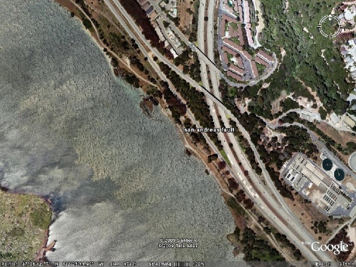
Transform • Dua lempeng saling berpapasan; bergeser satu sama yang lain – Gempabumi sebagai hasil pergerakan ini
Batas Lempeng • 3 Tipe – Divergen – Konvergen – Transform Motion 12. 9
Peta lempeng- lempeng tektonik
“BERTEMU” (subduksi) MEMISAH DIRI Peta Interaksi Lempeng BERPAPASAN
Mengenal Gerak Relatif Lempeng Paleomagnetisme Volkanisme Pengukuran geodetik (GPS) Studi mekanisme fokus gempa
PALEOMAGNETISME PEMBALIKAN MEDAN MAGNIT SEJALAN DENGAN PERUBAHAN EVOLUSI BUMI Magnet 12. 3
Volkanisme hotspot : lempeng bergerak, sumber tetap. Rangkaian gunung api Hotspot 1. 2 Corr 12. 2 Volkan 12. 1. 2
Global Plate Motion from GPS
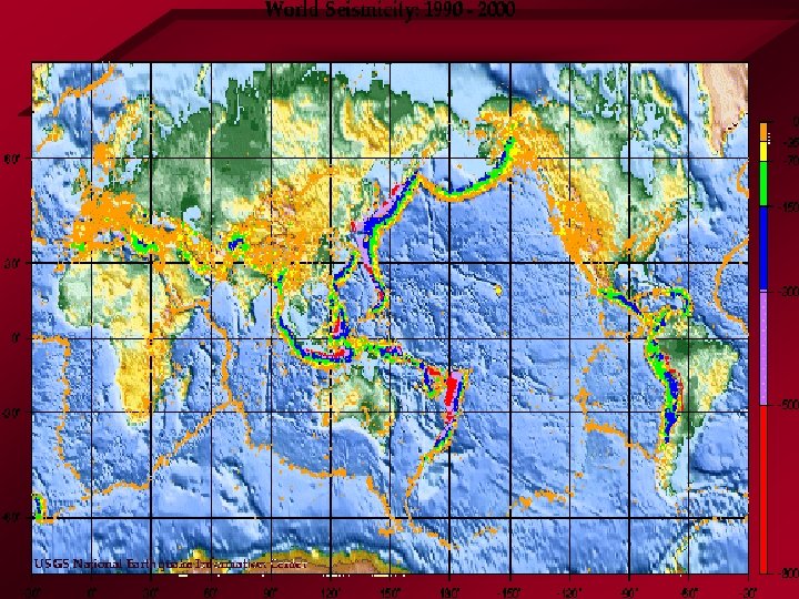
Seismisitas (Seismicity)
Seismisitas Australia, Indonesia dan New Zealand gempa 12. 1. 2
Quiz • Jelaskan secara singkat (lengkapi dengan gambar) mekanisme batas lempeng • Jelaskan secara singkat bagaimana cara mengetahui/ mempelajari pergerakan kerak bumi • Buatlah sketsa struktur dan komposisi bumi (lengkapi dengan notasi
Definition • Positioning is a process of defining spatial relation of an object with respect to another object or reference by distance (horizontal or vertical and angle) Q P SPQ
Reference • In 2 -dimensional space, position of an object is usually referred to Cartesian coordinate system • P is located y in x. P and y. P P (x. P, y. P) y. P x
Position on Earth • Position of an object on Earth is expressed in geographic coordinate
Satellite Positioning • Modern technique in positioning employs Global Positioning System (GPS) satellite
GPS Receivers • Users receive position data anytime and anywhere on a GPS receiver • Performance of GPS receivers range from simple handheld gadgets to geodetic types
Positioning Application • Navigation: – Aircraft, marine vessel, land traffic, etc. • Survey: – Field sampling, etc. • Mapping: – Road, river, parcel boundary, etc. • Monitoring: – Plate movement, land slide, etc.
Global Positioning System (GPS) Jaringan GPS Copyright: Irwanm@gd. itb. ac. id
Global Plate Motion from GPS
Regional Motion from GPS Malaysia (MASS) : 18, Thailand (Game-T) : 3, Indonesia (Sugar+FORSGC+IGS) : 11, ITB-Nagoya : 1 Total continue: 33 and 4 newly constructed GPS by Nagoya Univ. Time : 2004 -2006
Regional Motion from GPS Copyright: Irwanm@gd. itb. ac. id
Regional Motion from GPS Interseismic deformation can not be explained only by full coupling of Indo-Austria and Sunda block. More source(s) are needed
Regional Motion from GPS
Probability of earthquake occurrence versus GPS Observation Strain Critical stress Stress drop (~1 MPa) Stress build-up (~30 Pa/day or ~10 k. Pa/yr) time Recurrence interval (~100 yr)
Horizontal displacement due to the 2004 Sumatra Eq
Horizontal displacement due to the 2009 Manokwari Earthquake