Schedule for the Remainder of the Semester DATE


- Slides: 26

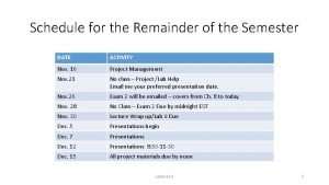
Schedule for the Remainder of the Semester DATE ACTIVITY Nov. 16 Project Management Nov. 21 No class – Project /Lab Help Email me your preferred presentation date. Nov. 26 Exam 2 will be emailed – covers from Ch. 8 to today Nov. 28 No Class – Exam 2 Due by midnight EST Nov. 30 Lecture Wrap up/Lab 9 Due Dec. 5 Presentations begin Dec. 7 Presentations Dec. 12 Presentations 8: 30 -11 -30 Dec. 15 All project materials due by noon Lecture 16 1

Project Presentation Example Lecture 16 2

Project Paper • Length – long enough to cover the subject, short enough to make it interesting (average length is 5 to 6 pages plus appendices). • Format: • • • Introduction Methods Results Discussion Conclusion Appendices • Data sources • Table inventory • Data dictionary Lecture 16 3

Lab 9 – Tracking Seal Movement Lecture 16 4

The GIS Project First Steps Lecture 16 5

https: //blogs. esri. com/esri-insider/files/2014/09/building. jpg Lecture 16 6

Introduction • Designing a GIS project. • What is the nature of the project? • Is it a one-time project or one that needs to be maintained • What is the scope of the project? • Project management and implementation. • Can you deliver the project on time? • Can you deliver a project of the appropriate quality? • Evaluation of the application. • Were you successful? • Do you need to make changes? Lecture 16 7

Stages in Developing an Application • Problem identification • Interview the client(s) – Needs Assessment • Rich Picture • Root Definition • Designing a Data Model • Conceptual data • Physical Data • Determining the Analysis Lecture 16 8

Figure 12. 4 The system development life cycle Lecture 16 9

1. Problem Identification • Problem types: • Structured - A problem which can be broken down into a series of welldefined steps. • Unstructured - A problem that requires the use of intuition, reasoning, and memory. • A rich picture is a schematic view of the problem being addressed. • A root definition is a statement of an individual or group’s perspective on the problem Lecture 16 10

Rich Pictures • An effective tool for analyzing problems and expressing ideas. • Can focus attention on important issues. • Help individuals visualize and discuss the roles they have in an organization. • Establish exactly which aspects of the information flows within the organization and are going to be covered by the system. • Allow individuals to express worries, conflicts and responsibilities. Lecture 16 11

How to Draw A Rich Picture • Start with a short problem statement near the center of the page. • Place all of the relevant key words around it. • Write down everything you can think of. • You can remove irrelevant words later. • Do not expect to complete your rich picture at once • Start with a rough version and develop over time. Lecture 16 12

Example 1 Rich Pictures provide a mechanism for learning about complex or ill-defined problems by drawing detailed ("rich") representations of them. Typically, rich pictures follow no commonly agreed syntax, usually consist of symbols, sketches or "doodles" and can contain as much (pictorial) information as is deemed necessary. Lecture 16 13

Components Drawing Guidelines Comments Actors – stick figures These are the users of the system. An actor may represent a group of users. An actor may carryout any number of operations Eyes External observers Speech bubble Personal or group opinions Crossed swords Used to express conflict between actors Operations (Processes or Functions) – circles or ovals with descriptive labels What the system does. Each operation is executed by an actor or another operation. Data Stores (Tables) – rectangles with descriptive labels Tables in your database or files in the system. It is only necessary to show the type of data they contain. Arrows – arrows with descriptive labels Arrows show the direction of information flow among, actors, data stores and operations. Boundary The system boundary encloses the operations you are responsible for. 14

Example 2 http: //cci. drexel. edu/faculty/sgasson/SSMIntro/image 006. gif 15

Root Definition • Short textual statements which define the important elements of the relevant system being modelled - rather like mission statements. • What the system does – X • How it does it – Y • Why it’s being done – Z • Different users have different views of a problem. The system developer must get them to agree on a common root definition. Lecture 16 16

Soft Systems Methodology with Root Definition Lecture 16 17

Example 1 • A university owned and operated system to award degrees and diplomas to suitably qualified candidates (X), by means of suitable assessment (Y), (in conformance with national standards), in order to demonstrate the capabilities of candidates to potential employers (Z). Lecture 16 18

Problem Identification Questions • • • What is the problem you wish to address with GIS? Is it structured or unstructured? Can it be summarized in a rich picture? Does the rich picture include views of all users as well as those affected by the GIS? Can a single root definition be defined for the problem? Is the definition acceptable to all users as well as those affected by the GIS? If it is too difficult to draw a rich picture or formulate a root definition, the problem may be unstructured. These are difficult to address with a GIS Can the problem be tackled with available resources? Should the problem be broken into smaller parts? Lecture 16 19

2. Design and Choose a Data Model The conceptual data model is a high level view, independent of the computer system. • Identify the elements of the data model and their relationship to one another (flowchart) • Create a list of actions the system must perform. • Identify system inputs and outputs. • Group actions, inputs and outputs into a logical order, Lecture 16 20

• Maps and GIS are Models of Reality. • They model some aspects of reality, while ignoring or simplifying others. • Abstraction • The process of abstracting what can be sensed in the real world into symbols. • GIS Data Modeling • The process of abstracting from the real world for representation in a GIS. Lecture 16 21

Lecture 16 22

Lecture 16 23

Creating the Product • Choose the appropriate application. • Choose the appropriate data model. • Data acquisition. • Create the metadata. • Develop the application. • Test. • Implement. Lecture 16 24

Evaluation The GIS must be evaluated for: Accuracy Efficiency Effectiveness User needs analysis Cost Lecture 16 25

Deliver the System Lecture 16 26
 Remainder of the semester
 Record date dividends
 Dividend eligibility
 Wbs dan wpl audit
 Tack för att ni lyssnade
 Inköpsprocessen steg för steg
 Påbyggnader för flakfordon
 Egg för emanuel
 Tack för att ni har lyssnat
 Var finns arvsanlagen
 Vilotidsbok
 Rutin för avvikelsehantering
 Myndigheten för delaktighet
 Presentera för publik crossboss
 Formuö
 Mall debattartikel
 Var 1721 för stormaktssverige
 Tack för att ni har lyssnat
 Tobinskatten för och nackdelar
 Referatmarkering
 Varför kallas perioden 1918-1939 för mellankrigstiden
 Lågenergihus nyproduktion
 Stig karttecken
 Epiteltyper
 Lufttryck formel
 Multiplikation med decimaltal uppgifter
 Rbk mätning
