Faulting and Earthquakes in California Faulting Normal faults


, California,")


 trace looks smaller, it is because the 1906")
 in length erupted")


 - triple-decker")


 occurred in a heavily populated urban")


- Slides: 102
Faulting and Earthquakes in California
Faulting - Normal faults • Sierra Nevada fault is the most important example in California • March 27, 1872 Owens valley earthquake • 8. 5 M - California’s greatest • 29 killed • Cities on normal faults – Bishop, Reno, Carson City
Types of faults - Thrust faults • The southern boundary of the transverse range is a series of east trending thrust faults • Santa Monica fault system • Sierra Madre fault system • The 1994 Northridge earthquake was an example • These faults may be characterized by very high horizontal acceleration
Types of faults - Thrust faults • Thrust faults may be buried beneath parts of the Los Angeles basin and not visible on the surface • Cities on or very near thrust faults • Pasadena • all foothill communities
Types of faults - Strike slip faults • These faults dominate the geology of California • Active for 30 m. y. • 10's to 100's of miles of displacement • These are the most active faults in California • 6 out of 10 earthquakes occur on these faults
Types of faults - Strike slip faults • Right lateral faults are most common • They dominate the peninsular range and coast range • They trend NW-SE • Mostly active
Types of faults - Strike slip faults • San Andreas-San Jacinto faults are most important • Right lateral • 600 miles in length • 300+ miles of displacement • Fault makes a major bend through the transverse range
Types of faults - Strike slip faults • San Andreas-San Jacinto faults are most important • Studies by Caltech indicate 9 major San Andreas earthquakes since the 6 th century • Past events ~ 575, 665, 860, 965, 1190, 1245, 1470, 1745, 1857 • Average repeat interval of 160 years
Types of faults - Strike slip faults • San Andreas-San Jacinto faults are most important • 2 major historic earthquakes • (1) 1857 Fort Tejon - 8 M • (2) 1906 San Francisco - 8. 3 M
Diagram of southern California showing the San Andreas Fault as a master player in a tectonic setting that includes other faults and compressional fold belts
Types of faults – Strike slip faults • Offshore geology • Important because of proximity to large population centers • Geology is mostly right-lateral strike-slip faults • Cities on strike slip faults – San Bernardino, San Francisco
Historic Earthquakes
The April 18, 1906 San Francisco earthquake • Geology of the 1906 earthquake • Magnitude of 8. 3 is estimated • Earthquake produced 50 seconds of extreme shaking • The epicenter was 27 miles north of San Francisco • But the damage extended far south and east • Santa Rosa on deep, soft alluvium had worse damage than San Francisco even though it is 19 miles from the San Andreas
The April 18, 1906 San Francisco earthquake Isoseismal map for the San Francisco, California, earthquake of April 18, 1906. Isoseismals are based on MM intensity estimates from data. http: //neic. usgs. gov/neis/eq_depot/usa/1906_04_18_iso. html
The April 18, 1906 San Francisco earthquake • A surface rupture 270 miles long extended north and south of San Francisco • Surface offsets of 20 feet • Right-lateral displacement
The April 18, 1906 San Francisco earthquake • The damage to man-made structures • Unreinforced brick and combination brickframe buildings collapsed Mission Dolores at 16 th street, and the wrecked Parish church next to it. From the Archives of The Museum of the City of San Francisco
The April 18, 1906 San Francisco earthquake • The damage to man-made structures • The great fire • Water mains were broken to complicate an already inadequate system • 500 blocks burned – 28, 000 buildings • Fire burned for 3 days Crowds gather at Market and Laguna streets to flee and 3 nights the Great Fire. Building at lower center right still survives as do along Laguna. Almost all others pictured here burned. From the Archives of The Museum of the City of San Francisco
The April 18, 1906 San Francisco earthquake • The death count in San Francisco • The official 1906 city death count - only 260 people • The official San Francisco government policy of 1906 was to deny the importance of the earthquake • 1987 review by the San Francisco city archivist Crushed 427 Fire deaths 199 Exposure 116 Heart attacks 80 Suicide 86 Other* 190 Total 1498 *Includes drowning, disease, gunshot, dynamite, dysentery, and amputation
The April 18, 1906 San Francisco earthquake • Excellent book on the 1906 earthquake “The San Francisco earthquake” by Thomas Gordon • Also visit: Museum of the City of San Francisco - 1906 Earthquake and Fire • 16 Views of the Great Earthquake and Fire (in Power. Point)
The Loma Prieta earthquake of October 17, 1989
The Loma Prieta earthquake • Geological setting of the October 17, 1989 earthquake • The San Andreas and Hayward faults • Right-lateral strike slip faults
The Loma Prieta earthquake • Geological setting of the October 17, 1989 earthquake • The San Andreas and Hayward faults • The part of the fault that ruptured on October 17 th is a southern portion of the 280 -mile long 1906 break • This area was said to have had a 30 to 60% probability of a M 6 -7 earthquake in the next 20 years
The threat of earthquakes extends across the entire San Francisco Bay region, and a major quake is likely before 2030. Knowing this will help people make informed decisions as they continue to prepare for future quakes.
The Loma Prieta earthquake • Some basics of the October 17 th earthquake • Magnitude of 7. 1 • Epicenter was 10 miles north of Santa Cruz • Mercalli intensity depended greatly on the firmness of the earth • Rupture area is a southern portion of the 280 -mile long 1906 break http: //geopubs. wr. usgs. gov/fact-sheet/fs 151 -99/
The Loma Prieta earthquake
The Loma Prieta earthquake Isoseismal map for the Santa Cruz Mountains (Loma Prieta), California, earthquake of October 18, 1989.
The Loma Prieta earthquake • Some basics of the October 17 th earthquake • Maximum horizontal acceleration was 0. 45 - 0. 55 g's near the epicenter • The San Andreas Fault broke along a 25 -mile segment in the Santa Cruz Mountains • Focus 11 miles deep • Earth shifted in a right lateral direction 6. 5 feet horizontally and 4. 5 feet vertical up on the southwest side
The Loma Prieta earthquake • Types of geological damage • • No surface rupture (all subsurface) Lurch cracks Landsliding Liquefaction
The Loma Prieta earthquake • Types of geological damage • Lurch cracks • Abundant in an area about 3 miles wide near the epicenter • Regional stress • Weak, unconsolidated tertiary sedimentary rocks not being able to respond elastically to severe shaking • Cracks damaged pavement, sidewalks, buildings etc.
The Loma Prieta earthquake • Types of geological damage • Landsliding • Many landslides occurred in the mountains south of S. F. • They are almost entirely on south facing slopes • Many are old landslides that were reactivated • Some roads were closed
The Loma Prieta earthquake • Types of geological damage • Soil liquefaction • Liquefaction is caused by increased pore water pressure • This is an especially severe problem around the San Francisco bay • Large parts of the bay have either: • Soft, water-saturated natural sediment deposited by rivers • Soft sandy man-made fills partly from the 1906 earthquake
The Loma Prieta earthquake • Types of geological damage • The marina of San Francisco • Located 50 miles from the epicenter and still had a IX intensity • A lagoon was filled with 1906 debris to form today's Marina district • Damage included fires, collapsed buildings, broken utilities
An automobile lies crushed under the third story of this apartment building in the Marina District. The ground levels are no longer visible because of structural failure and sinking due to liquefaction. [J. K. Nakata, U. S. Geological Survey]
Smoldering remains of the apartment complex at the corner of Beach and Divisadero Streets, Marina District. [J. K. Nakata, U. S. Geological Survey]
The Loma Prieta earthquake • Types of geological damage • East Bay area • Soil liquefaction damaged: • the Oakland port facility • runway at Oakland international airport • and possibly the Nimitz freeway
The part of the Cypress freeway structure in Oakland, California, that stood on soft mud (dashed red line) collapsed in the 1989 Loma Prieta earthquake, killing 42 people. Adjacent parts of the structure (solid red) that were built on firmer ground remained standing. Seismograms (upper right) show that the shaking was especially severe in the soft mud. (Photograph by Lloyd S. Cluff)
Aerial view of collapsed sections of the Cypress viaduct of Interstate Highway 880. [H. G. Wilshire, U. S. Geological Survey]
The Loma Prieta earthquake • Types of geological damage • East Bay area • Comparison with 1906 • Areas that liquefied in 1906 also did so in 1989 • Water mains needed to fight fires that broke in 1906 did so in 1989 • Maps of damage and intensity for 1906 are similar to 1989
If the Loma Prieta (M~7. 0) trace looks smaller, it is because the 1906 (M~7. 8) earthquake released approximately 16 times more energy:
Sand boil or sand volcano measuring 2 m (6. 6 ft) in length erupted in median of Interstate Highway 80 west of the Bay Bridge toll plaza when ground shaking transformed loose water-saturated deposit of subsurface sand into a sand-water slurry (liquefaction). Vented sand contains marine-shell fragments. [J. C. Tinsley, U. S. Geological Survey]
The Loma Prieta earthquake • Human damage • Injuries • • 62 deaths 3, 757 injuries 12, 000 homeless $6 billion in property damage
The Loma Prieta earthquake • Buildings • No building constructed to code collapsed • Buildings on solid ground in the epicentral area did well if they were built to code • Buildings 50 miles away in San Francisco on weak fill did poorly
The Loma Prieta earthquake • Buildings • Older buildings sometimes did poorly because • • • General deterioration Not attached to the foundation Unreinforced masonry, brick or stone Lack of lateral reinforcement Pounding by adjacent buildings
The Loma Prieta earthquake • Bridges • The Nimitz freeway (rte 880) - triple-decker built between 1949 -1954 • Southbound lanes fell on the Oakland bound lanes killing 41 • Damage has been attributed to inadequate bracing and poor soil • Freeway was pre-1971 and funds for retrofitting for earthquake safety had been withdrawn • One span of the Oakland bay bridge fell • Cause uncertain
The Loma Prieta earthquake
Aerial view of the collapsed section of the San Francisco-Oakland Bay Bridge. View westward. [C. E. Meyer, U. S. Geological Survey]
The Loma Prieta earthquake • Predicted and actual events of October 17, 1989 • Predicted are based on a model 6. 5 to 7. 5 M earthquake on the Hayward fault • The following is a comparison of events predicted by the U. S. geological survey to occur based on a study of the Hayward fault compared to what actually occurred on October 17, 1989.
PREDICTED ACTUAL 1500 - 4500 deaths 55 deaths Modern schools are ok True Older schools damaged True Golden gate bridge open True (opened in 1937) Major freeway damage True SFO closed True (first ever closure) Bart closed True briefly Electricity off 100% area 24 hrs True 50% area 48 hrs True Oakland bay bridge closed True Water supply severely hurt True Communications overloaded True
Fort Tejon EQ January 9, 1857, ~8: 20 am PST Mw 8. 0 San Fernando EQ aka Sylmar EQ February 9, 1971, 6: 01 am PST MW 6. 6 Northridge EQ January 17, 1994 4: 30: 55 am PST MW 6. 7 Map of southern California, with epicenters of historic earthquakes (as far back as 1812) of particular note plotted over the background topography. Shown, too, are major highways (in tan) and the surface traces of major faults (in greenish-blue). This map does not show the epicenters of all earthquakes greater than magnitude 4. 5 recorded in the southern California area since the 19 th century. From: http: //www. scecdc. scec. org/clickmap. html
The 1971 San Fernando Earthquake • Facts • • Time: February 9, 1971, 6: 01 am PST Magnitude: Mw 6. 6; Intensity: XI Depth: 8. 4 km Length of shaking: 60 seconds! Type of faulting: thrust Fault involved: San Fernando Fault Zone; Minor offset reported on the eastern Santa Susana Fault Zone
The 1971 San Fernando Earthquake • Facts • Surface rupture in the Sylmar – San Fernando Valley area 19 km (12 miles) long • Maximum slip was up to 2 meters (6 feet)
Isoseismal map for the San Fernando, California, earthquake of February 9, 1971. Isoseismals are based on intensity estimates from data.
The 1971 San Fernando Earthquake • Damage • Over $500 million in property damage • Several hospitals suffered severe damage • Newly constructed freeway overpasses also collapsed • 65 deaths • Loss of life would have been greater had the EQ struck later in the day.
The 1971 San Fernando Earthquake • Results: • Building codes were strengthened • Alquist Priolo Special Studies Zone Act was passed in 1972. • The purpose of this act is to prohibit the location of most structures for human occupancy across the traces of active faults and to mitigate thereby the hazard of fault rupture.
AP Map of the San Fernando Valley
Damage to the Olive View Community Hospital in Sylmar after the 1971 Sylmar Earthquake
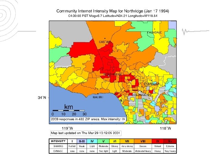
The 1994 Northridge Earthquake • Facts • Time: January 17, 1994, 4: 30: 55 Am PST • Location: 20 Miles West-northwest of Los • • • Angeles, 1 Mile South-southwest of Northridge Magnitude: Mw 6. 7 Type Of Faulting: blind thrust Fault involved: Northridge Thrust Depth: 18. 4 Km Duration of shaking: 10 -20 seconds
The 1994 Northridge earthquake (M = 6. 7) occurred in a heavily populated urban area northwest of Los Angeles, and had many similarities to the 1971 San Fernando earthquake (M = 6. 7). The 1987 Whittier Narrows earthquake (M=5. 9), like the Northridge shock, occurred on a buried, previously unknown fault. The three shocks and their effects on the surrounding urbanized areas (grey) are compared throughout this report.
To the left is an overhead view of the topography near the Northridge Earthquake epicenter. This is a cross section of the above area. The large yellow sphere represents the mainshock. The red dots represent the aftershocks. To view an mpeg movie of the rotating plane of aftershocks, click on the upper image.
The 1994 Northridge Earthquake • Geology of the Northridge Earthquake • Significantly deformed the Earth’s crust over an area of about 4, 000 square kilometers • Santa Susana Mountains were pushed up by at least 40 centimeters • Northridge uplifted at least 20 cm • Other parts of the Valley 20 -40 cm
The gentle, roughly symmetrical doming of the Earth’s surface is a typical result of slip on a deeply buried fault. The greatest uplift is centered over the northern part of the San Fernando Valley, where the buried, dipping fault plane comes closest to the surface.
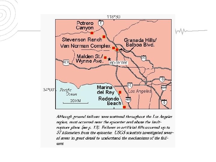
The 1994 Northridge Earthquake • Geological damage • Ground failures of many types at distances up to about 90 kilometers from the epicenter • Include: • Surface Ruptures • Landsliding • Soil Liquefaction
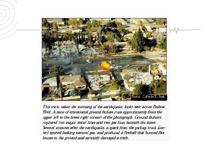
The 1994 Northridge Earthquake • Geological damage • Surface Ruptures • Most in the Granada Hills-Mission Hills area • Was the principal cause of damage to single-family homes and buried utilities • Loose or poorly compacted fills primary cause • Areas reengineered after 1971 Sylmar EQ performed very well
The 1994 Northridge Earthquake • Geological damage • Landsliding • Thousands triggered over 10, 000 square kilometers • Mostly in sparsely populated areas • Destroyed homes, roads, and utility lines, and blocked streams • Created huge dust clouds – Valley Fever
The 1994 Northridge Earthquake • Damage to Buildings: • Severe damage to buildings, freeways and gas lines due to location • Thousands of buildings were significantly damaged • +1, 600 were later “red-tagged” • 7, 300 buildings were “yellow-tagged” • Many thousands of other structures incurred at least minor damage. • Estimated losses of 15 - 20 billion dollars
The 1994 Northridge Earthquake • Human Death and Injury • Fifty-seven people died • +9, 000 were injured • +20, 000 were displaced from their homes by the effects of the quake
The 1994 Northridge Earthquake • EQ had an immense impact because it was centered directly beneath a heavily populated and built-up urban region. • The early morning timing of the earthquake spared many lives that otherwise might have been lost in collapsed parking buildings and on failed freeway structures.
Buildings and Earthquakes
Types of home construction • Wood frame buildings • By far the most desirable small property investment • Light weight • Flexible Image: http: //www. woodengineering. com Image: http: //www. toolbase. org
Types of home construction • Wood frame buildings • Why wood frame houses are damaged in earthquakes • Soft, unstable ground • A weak or inadequately located foundation • Old, poorly maintained or a new poorly constructed building • Insufficient lateral bracing or inadequate number of bearing walls and columns • Inadequate stilts for hillside homes • Heavy roofing such as clay tiles
Lateral braces, plywood sheeting and foundation bolts can strengthen a wood-frame house. Natural Hazards & Disasters, 1/e; Hyndman & Hyndman
Types of home construction • Wood frame buildings • Lateral bracing adds great strength • Generally required in western U. S. • 1” x 4” diagonal across studs from top to sole plate • Generally adequate in following cases • 6+ earthquakes • Good foundation material • Single story building • No stucco/masonry veneer Image: Natural Hazards & Disasters, 1/e; Hyndman & Hyndman
Types of home construction • Wood frame buildings • Lateral bracing adds great strength • Shear-wall bracing 3/8” plywood • Recommended for strong tremor areas • Metal straps for diagonals are a poor substitute • Steel framing and anchoring devices strengthen connections of different components Image: Natural Hazards & Disasters, 1/e; Hyndman & Hyndman
Types of home construction • Wood frame houses with stucco veneers • Possible construction methods • Stucco is applied to wire mesh that is carefully nailed to plywood sheathing • Seldom damaged in large earthquakes • Buildings with stucco applied to sheetrock or plasterboard backing or 2 story buildings without plywood shearwalls suffer badly Image: http: //www. masonrytechnology. com
Types of home construction • Wood frame houses with stucco veneers • Remedies • Carry earthquake insurance to cover the stucco • Strengthen the connection between foundation, sill, and studs - much damage occurs here • Remove stucco and install plywood sheathing Images: http: //www. halquiststone. com
Types of home construction • Wood frame with masonry veneer • • Considerably more dangerous Extra weight means extra inertia Poor connection between veneer and building Poor quality mortar
Types of home construction • Unreinforced brick buildings • Consistently suffer severe damage • Brick is heavy and inflexible & can't withstand lateral force • Only a wood frame interior can prevent total collapse • Quality of the mortar is particularly important
Architectural details • Foundations • Continuous tie wall foundation • Reinforced concrete forms a base beneath each bearing wall • Allows building to move as a unit Image: http: //www. bia. org
Architectural details • Foundations • Reinforced concrete slab • Behave well on inferior ground due to their rigidity • Should be reinforced in excess of code Image: http: //www. concrete-slab-foundation. com/
Architectural details • Foundation connection to wood frame homes • Poor anchorages between the sill and foundation • Building slides off the foundation if it is not properly bolted • Clamps may be installed on old homes Image: http: //www. oldhouseweb. com
Architectural details • Foundation connection to wood frame homes • Cripple studs - raise floor from the foundation • Often poorly braced - new homes destroyed in S. F. • Install plywood sheathing to prevent damage Image: http: //www. oldhouseweb. com
Architectural details • Foundation connection to wood frame homes • Foundation damage existing • Rotten wood or termites are common • Wide cracks in foundation concrete
Architectural details • Foundation connection to wood frame homes • Houses on stilts or pilings • Requires exceptionally stable earth • Columns and floor joists of welded steel are best • Wood columns require a plywood sheath Image: http: //www. state. me. us
Architectural details • Columns and walls • Wood columns may fail because: • • Rotting due to poor drainage along the top of the sill Termite damage Column not continuous from sill to roof Horizontal members improperly connected to columns • Extremely common yet easily corrected
Architectural details • Columns and walls • Masonry columns • Avoid masonry buildings or masonry columns on frame buildings Damage to masonry columns during the September 3, 2000 Yountville/Napa, California Earthquake (http: //nisee. berkeley. edu/yountville/)
Architectural details • Roofs • Generally hold up well except: • Poor connections with vertical members • Too heavy a roof • Traditional clay tile is 1200 lbs/100 sq ft or 9 tons for 1500 sq ft
Architectural details • Large windows and doors • Damage is often concentrated in these areas • Plywood sheathing and interior paneling will help
Architectural details • Parapets • Present a great hazard • Common on flat roofs • Modifies the wind flow over the roof so that the pressure on it is more uniformly distributed
The fourth-story wall and overhanging brick parapet of an unreinforced building in San Francisco collapsed onto the street during the 1989 Loma Prieta earthquake. Natural Hazards & Disasters, 1/e; Hyndman & Hyndman
Architectural details • Chimneys • Pre-1960 chimneys are commonly not reinforced with vertical steel bars • Pre-1960 chimneys are commonly not strapped to the building • Chimneys extending >3 feet above roof should be shortened Source: FEMA
Architectural details • Utilities • Gas • Know where the main feeder valve is • Install a gas shut off valve Image: http: //www. townparkconstruction. com Image: http: //www. socalgas. com
Architectural details • Utilities • Plumbing • Minimize damage by knowing where the main shut valve is • Water heaters • They are very vulnerable and commonly cause fires • They should be bolted to the floor and strapped to the wall
Architectural details • Furnishings • • Hanging lamps and pictures Free standing bookcases Cabinets for food, drink, and glassware Beds Image: http: //www. oldhouseweb. com
Architectural details A view of damage to a second kitchen in a townhouse near the Northridge Fashion Center. An occupant cut her foot on glass when she ran into the kitchen area in the predawn hours after the earthquake. Electrical power to the area was out at the time. Photo Credit: J. Dewey, U. S. Geological Survey. (http: //www. johnmartin. com/earthquakes/eqshow/no 1_0019. htm)
Conclusions • Similar events will occur repeatedly in southern California • The 1994 Northridge earthquake is an example • Richter magnitude 6. 7; approximately 60 killed • Severe lurching and cracking occurred • CSUN $300 million damage • Apartment buildings collapsed • Unreinforced buildings collapsed or heavily damaged
Conclusions • Similar events will occur repeatedly in southern California • A future San Andreas or Newport Inglewood fault earthquake may produce widespread soil liquefaction • The Newport Inglewood could produce a 7. 2 M earthquake nearly centered on LA • Liquefaction along river channels and much of Orange County is expected
Conclusions • Geological conditions strongly influence damage • Geology determines: • • Where fault rupture will occur How hard the ground will shake Where soil liquefaction will occur Where landslides occur
Conclusions • Geological conditions strongly influence damage • We know: • A large earthquake is expected in S. California within our lifetime • Shaking levels and geologic response can be predicted • Preparation will greatly reduce the impact • “Those who cannot remember the past are condemned to repeat it” - George Santayana - philosopher & poet • Make an earthquake kit for your home, your car and your office!
~ End ~