
Petroleum Geology Copyright 2003 Schlumberger Unpublished work All
Petroleum Geology © Copyright 2003 Schlumberger. Unpublished work. All rights reserved. This work contains confidential and proprietary trade secrets of Schlumberger and may not be copied or stored in an informational retrieval system, transferred, used, distributed, translated or retransmitted in any form or by any means, electronic or 1 mechanical, in whole or part, without the express written permission of the copyright owner.
Outline Ø Ø Ø Ø Ø Petroleum systems Geologic principles and geologic time Rock and minerals, rock cycle, reservoir properties Hydrocarbon origin, migration and accumulation Sedimentary environments; stratigraphic traps Plate tectonics, structural geology Structural traps Geophysical methods Importance to Schlumberger 2
Petroleum System A Petroleum System requires timely convergence of certain geologic factors and geologic events. These Include: Seal or cap rock Reservoir rock Migration Mature source rock 3
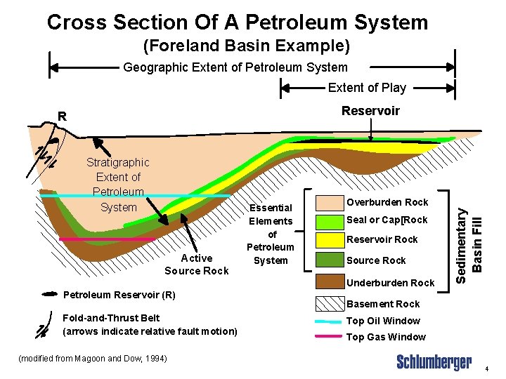
Cross Section Of A Petroleum System (Foreland Basin Example) Geographic Extent of Petroleum System Extent of Play Reservoir Stratigraphic Extent of Petroleum System Active Source Rock Essential Elements of Petroleum System Overburden Rock Seal or Cap[Rock Reservoir Rock Source Rock Underburden Rock Petroleum Reservoir (R) Fold-and-Thrust Belt (arrows indicate relative fault motion) Sedimentary Basin Fill R Basement Rock Top Oil Window Top Gas Window (modified from Magoon and Dow, 1994) 4
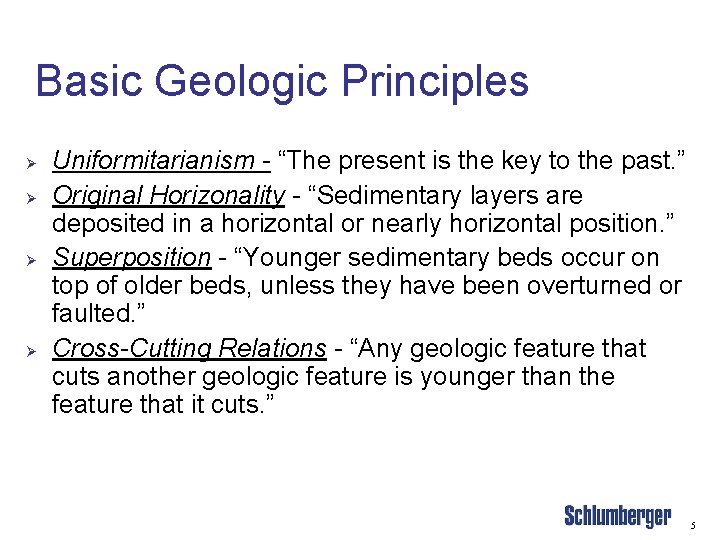
Basic Geologic Principles Ø Ø Uniformitarianism - “The present is the key to the past. ” Original Horizonality - “Sedimentary layers are deposited in a horizontal or nearly horizontal position. ” Superposition - “Younger sedimentary beds occur on top of older beds, unless they have been overturned or faulted. ” Cross-Cutting Relations - “Any geologic feature that cuts another geologic feature is younger than the feature that it cuts. ” 5

Cross-Cutting Relationships K J I H G Angular Unconformity C E D ou e Ign ill S s Igneous Dike F B A 6

7
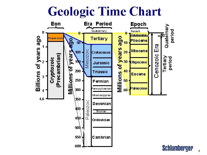
4 4. 6 150 Mesozoic 100 Cretaceous Jurassic 200 Triassic 250 Permian Pennsylvanian 300 Recent 0 Pleistocene 10 20 Pliocene Miocene 30 Oligocene 40 Eocene Cenozoic Era 3 Tertiary 50 50 60 Paleocene Mississippian 350 400 450 Paleozoic 1 Millions of years ago Phanerozoic 2 Quaternary 0 Cryptozoic (Precambrian) Billions of years ago 0 Epoch Tertiary period Era Period Millions of years ago Eon Quaternary period Geologic Time Chart Devonian Silurian Ordovician 500 550 Cambrian 600 8
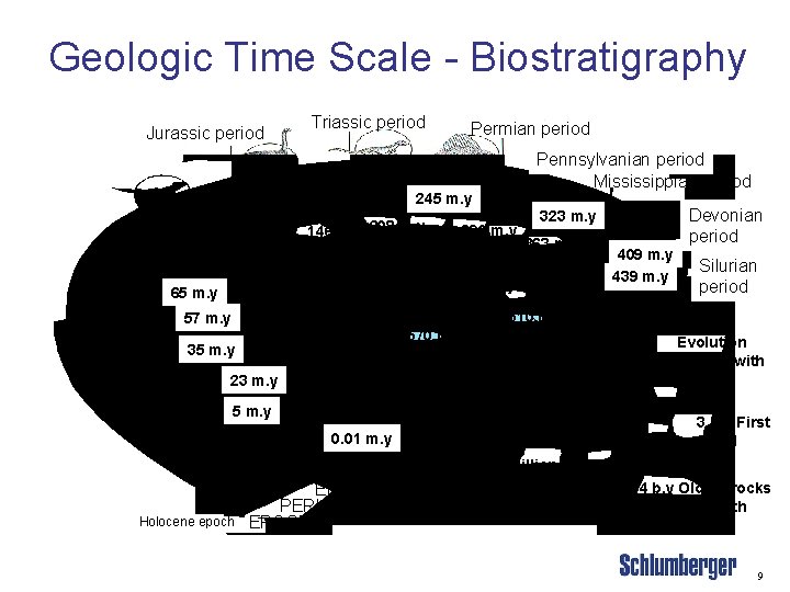
Geologic Time Scale - Biostratigraphy Jurassic period Triassic period Permian period Pennsylvanian period Mississippian period 245 m. y 146 m. y 208 m. y 290 m. y 363 m. y 1 b. y 65 m. y 510 m. y 570 m. y 35 m. y 23 m. y 5 m. y 0. 01 m. y Holocene epoch ERA PERIOD EPOCH Devonian period 323 m. y 4. 6 billion years ago 409 m. y 439 m. y Silurian period 2 b. y Evolution of cells with nucleus 3 b. y First fossil cells 4 b. y Oldest rocks dated on Earth 9

Rocks 10
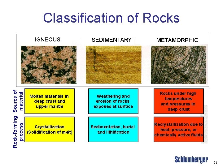
Classification of Rocks Rock-forming Source of process material IGNEOUS SEDIMENTARY METAMORPHIC Molten materials in deep crust and upper mantle Weathering and erosion of rocks exposed at surface Rocks under high temperatures and pressures in deep crust Crystallization (Solidification of melt) Sedimentation, burial and lithification Recrystallization due to heat, pressure, or chemically active fluids 11
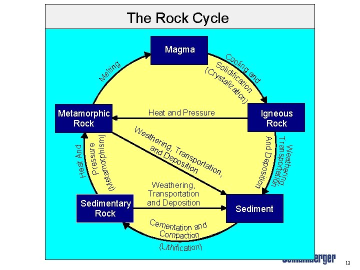
The Rock Cycle Magma nd M el t g in Co So oling (Cr lidi ys fic a tal at iza n i o n) tio Sedimentary Rock Heat and Pressure We ath eri an ng, T d D ran ep osi sport tion atio n, Weathering, Transportation and Deposition Igneous Rock Weather Transportaitng, ion And Dep o s i t ion And Heat ure Press orphism) m a t (Me Metamorphic Rock Sediment Ceme ntation and Compaction (Lithification) 12

Igneous Rocks Comprise 95% of the Earth's crust. Originated from the solidification of molten material from deep inside the Earth. There are two types: • Volcanic - glassy in texture due to fast cooling. • Plutonic - slow-cooling, crystalline rocks. 13
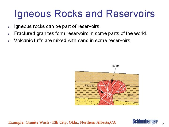
Igneous Rocks and Reservoirs Ø Ø Ø Igneous rocks can be part of reservoirs. Fractured granites form reservoirs in some parts of the world. Volcanic tuffs are mixed with sand in some reservoirs. Example: Granite Wash - Elk City, Okla. , Northern Alberta, CA 14
Metamorphic Rocks Ø Ø Ø 2) Metamorphic rocks formed by the action of temperature and/or pressure on sedimentary or igneous rocks. Examples are • Marble - formed from limestone • Hornfels - from shale or tuff • Gneiss - similar to granite but formed by metamorphosis Field Example: 1. Point Arguello - Monterey Formation is actually layers of fractured Chert and Shale. Oil is in the fractures 2. Long Beach, Calif. - Many SS producers on an Anticline above fractured Metamorphic basement rock 3. Austin, TX eastward - Lava flows of Basalt (Serpentine) from Volcanoes in ancient Gulf of Mexico 15
Sedimentary Rocks Ø Ø Ø These are the most important for the oil industry as it contains most of the source rocks and cap rocks and a majority of the reservoirs. Sedimentary rocks come from the debris of older rocks and are split into two categories Clastic and Non-clastic. • Clastic rocks - formed from the materials of older rocks by the actions of erosion, transportation and deposition. • Non-clastic rocks - from chemical or biological origin and then deposition. 16

Rock Classification Clastics Rock type Particle diameter Ø Conglomerate Pebbles 2 - 64 mm Ø Sandstone Sand. 06 - 2 mm Ø Siltstone Silt. 004 -. 06 mm or 4 to 65 microns Ø Shale Clay <. 004 mm or 4 microns Non-Clastics Rock type Ø Limestone Ø Dolomite Ø Salt Ø Anhydrite Ø Gypsum Ø Coal Composition Ca. CO 3 Ca. Mg(CO 3)2 Na. Cl Ca. SO 4. 2 H 2 O Carbon 17
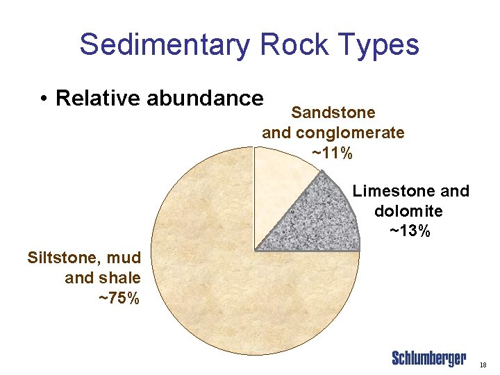
Sedimentary Rock Types • Relative abundance Sandstone and conglomerate ~11% Limestone and dolomite ~13% Siltstone, mud and shale ~75% 18
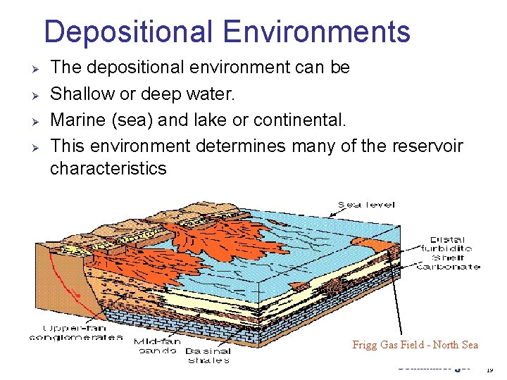
Depositional Environments Ø Ø The depositional environment can be Shallow or deep water. Marine (sea) and lake or continental. This environment determines many of the reservoir characteristics Frigg Gas Field - North Sea 19

Depositional Environments Ø Ø Ø Continental deposits are usually dunes. A shallow marine environment has a lot of turbulence hence varied grain sizes. It can also have carbonate and evaporite formation. A deep marine environment produces fine sediments. 20
Depositional Environments Ø The depositional characteristics of the rocks lead to some of their properties and the reservoir property. • • Ø Ø The reservoir rock type clastic or non-clastic. The type of porosity (especially in carbonates) is determined by the environment plus subsequent events. The structure of a reservoir can also be determined by deposition; a river, a delta, a reef etc. This can also lead to permeability and producibility of these properties are often changed by further events. 21
Clastic Reservoirs Ø Consolidated and unconsolidate sands Ø Porosity • Ø Permeability • Ø Determined mainly by the packing and mixing of grains. Determined mainly by grain size and packing, connectivity and shale content. Fractures may be present. 22
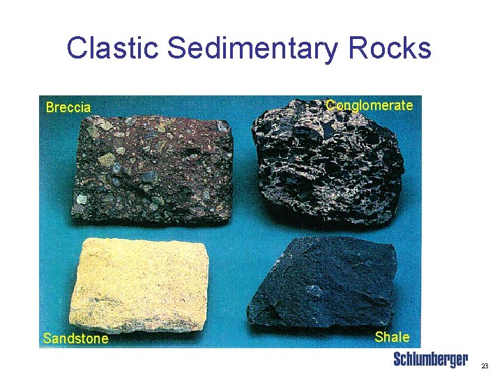
Clastic Sedimentary Rocks Breccia Sandstone Conglomerate Shale 23
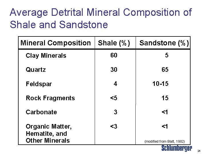
Average Detrital Mineral Composition of Shale and Sandstone Mineral Composition Shale (%) Sandstone (%) Clay Minerals 60 5 Quartz 30 65 4 10 -15 <5 15 3 <1 <3 <1 Feldspar Rock Fragments Carbonate Organic Matter, Hematite, and Other Minerals (modified from Blatt, 1982) 24
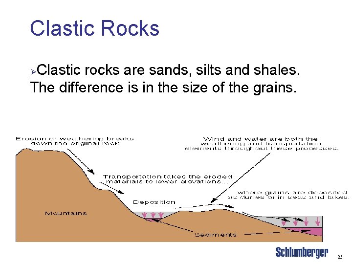
Clastic Rocks Clastic rocks are sands, silts and shales. The difference is in the size of the grains. Ø 25
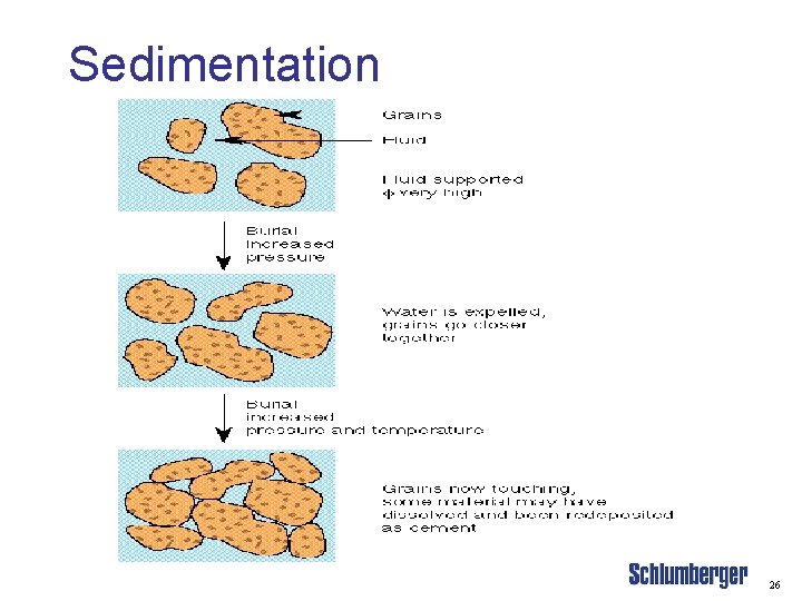
Sedimentation 26

Sedimentation Ø Sedimentary muds become sedimentary rocks. • • Ø Ø Calcareous muds become limestone. Sands become sandstone. Grains in the matrix and the fluids reacting to create new minerals changing the matrix and porosity. Fluids can also change creating a new set of minerals. This whole process is called Diagenesis. 27
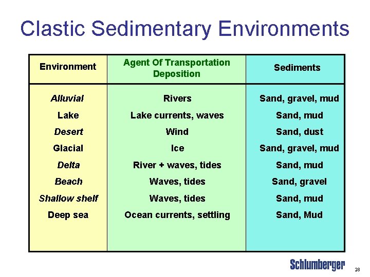
Clastic Sedimentary Environments Environment Agent Of Transportation Deposition Sediments Alluvial Rivers Sand, gravel, mud Lake currents, waves Sand, mud Desert Wind Sand, dust Glacial Ice Sand, gravel, mud Delta River + waves, tides Sand, mud Beach Waves, tides Sand, gravel Shallow shelf Waves, tides Sand, mud Deep sea Ocean currents, settling Sand, Mud 28
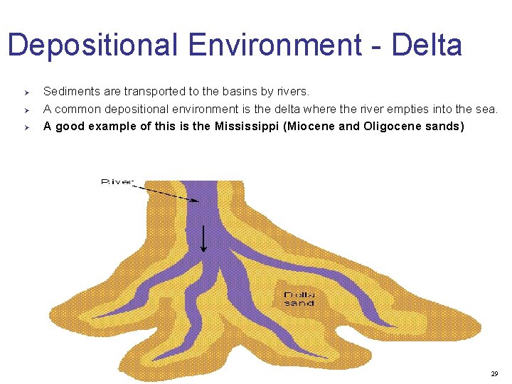
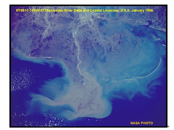
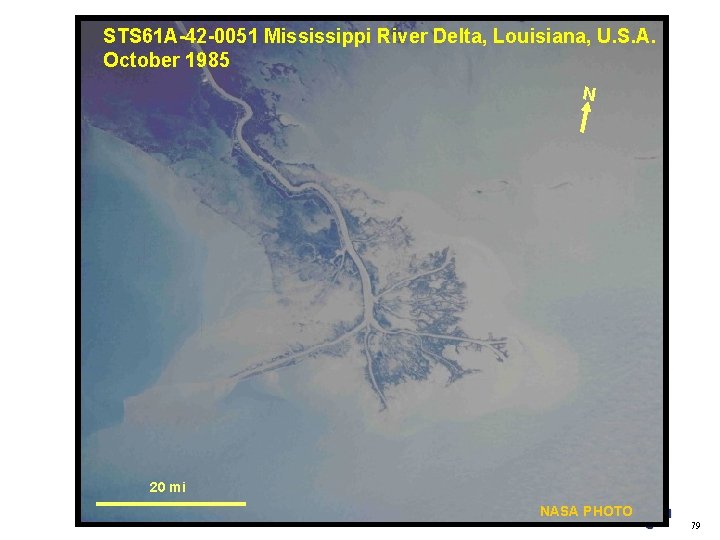
Depositional Environment - Delta Ø Ø Ø Sediments are transported to the basins by rivers. A common depositional environment is the delta where the river empties into the sea. A good example of this is the Mississippi (Miocene and Oligocene sands) 29
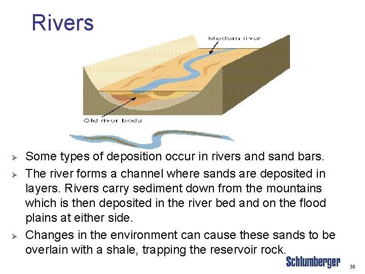
Rivers Ø Ø Ø Some types of deposition occur in rivers and sand bars. The river forms a channel where sands are deposited in layers. Rivers carry sediment down from the mountains which is then deposited in the river bed and on the flood plains at either side. Changes in the environment can cause these sands to be overlain with a shale, trapping the reservoir rock. 30
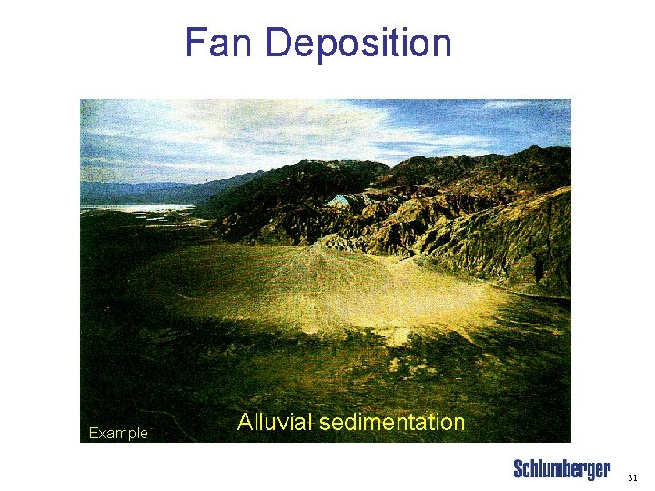
Fan Deposition Example Alluvial sedimentation 31
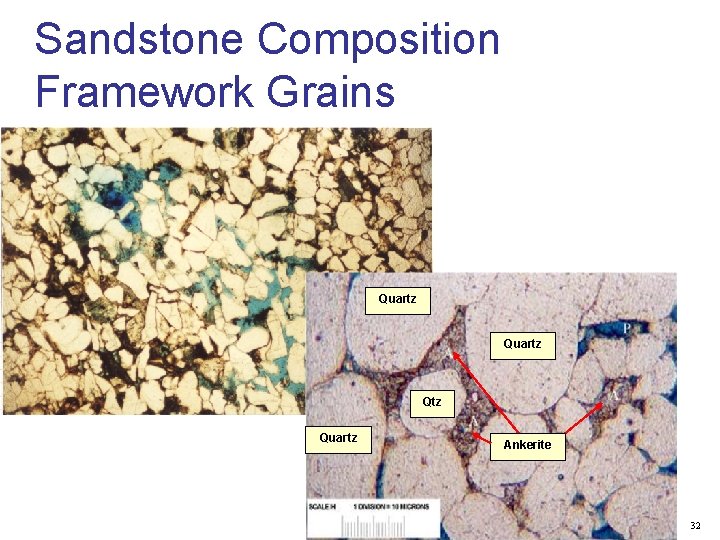
Sandstone Composition Framework Grains Qtz Quartz Qtz Qtz Quartz Ankerite 32
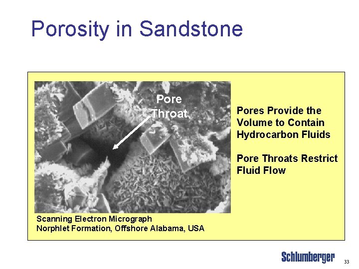
Porosity in Sandstone Pore Throat Pores Provide the Volume to Contain Hydrocarbon Fluids Pore Throats Restrict Fluid Flow Scanning Electron Micrograph Norphlet Formation, Offshore Alabama, USA 33
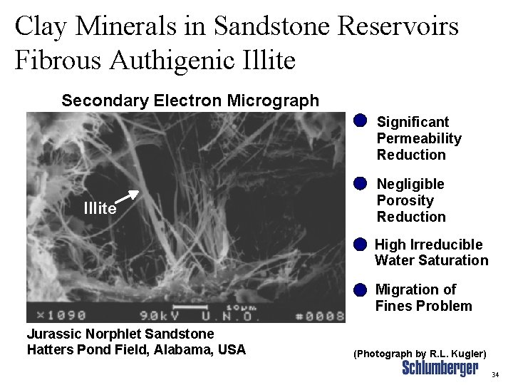
Clay Minerals in Sandstone Reservoirs Fibrous Authigenic Illite Secondary Electron Micrograph Significant Permeability Reduction Illite Negligible Porosity Reduction High Irreducible Water Saturation Migration of Fines Problem Jurassic Norphlet Sandstone Hatters Pond Field, Alabama, USA (Photograph by R. L. Kugler) 34
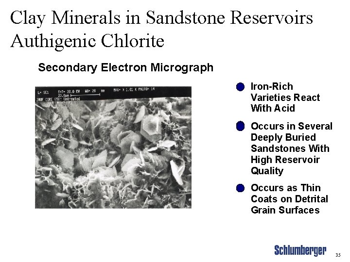
Clay Minerals in Sandstone Reservoirs Authigenic Chlorite Secondary Electron Micrograph Iron-Rich Varieties React With Acid Occurs in Several Deeply Buried Sandstones With High Reservoir Quality Occurs as Thin Coats on Detrital Grain Surfaces 35
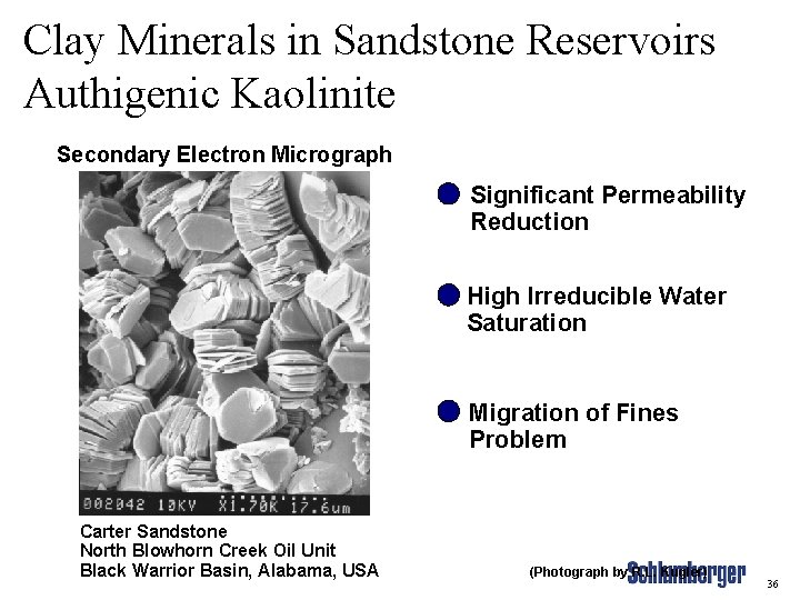
Clay Minerals in Sandstone Reservoirs Authigenic Kaolinite Secondary Electron Micrograph Significant Permeability Reduction High Irreducible Water Saturation Migration of Fines Problem Carter Sandstone North Blowhorn Creek Oil Unit Black Warrior Basin, Alabama, USA (Photograph by R. L. Kugler) 36
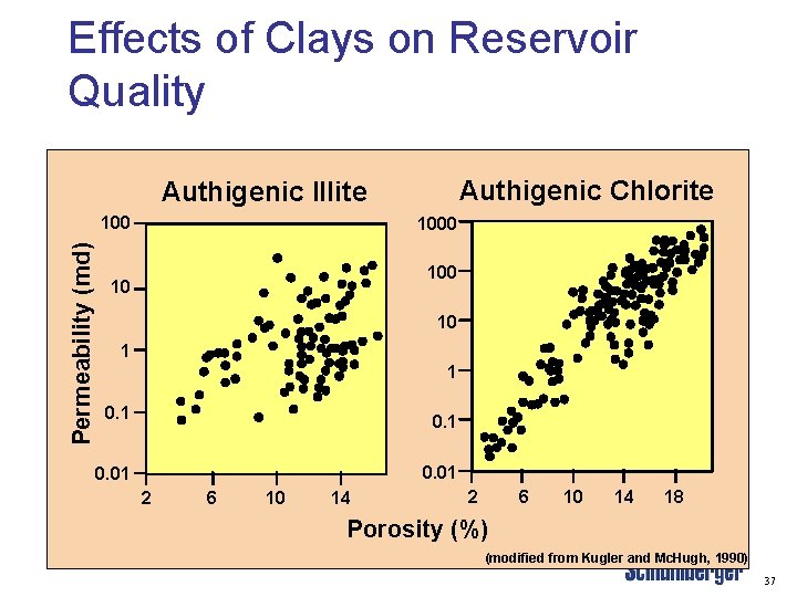
Effects of Clays on Reservoir Quality Authigenic Chlorite Authigenic Illite Permeability (md) 1000 10 10 1 1 0. 01 2 6 10 14 18 Porosity (%) (modified from Kugler and Mc. Hugh, 1990) 37
Carbonate Reservoirs Ø Ø Carbonates (limestone and dolomite) normally have a very irregular structure. Porosity: • Ø Permeability: • Ø Determined by the type of shells, etc. and by depositional and post-depositional events (fracturing, leaching, etc. ). Determined by deposition and post-deposition events, fractures. Fractures can be very important in carbonate reservoirs. 38
Carbonate types Ø Ø Ø Chalk is a special form of limestone (Ca. CO 3) and is formed from the skeletons of small creatures (cocoliths). Dolomite (Ca. Mg(CO 3)2) is formed by the replacement of some of the calcium by a lesser volume of magnesium in limestone by magnesium. Magnesium is smaller than calcium, hence the matrix becomes smaller and more porosity is created. Evaporites such as Salt (Na. Cl) and Anhydrite (Ca. SO 4) can also form in these environments. 39
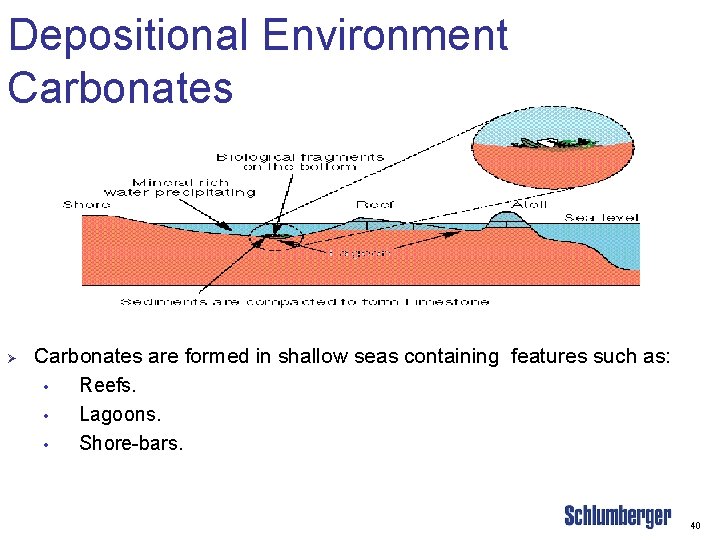
Depositional Environment Carbonates Ø Carbonates are formed in shallow seas containing features such as: • Reefs. • Lagoons. • Shore-bars. 40
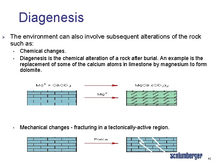
Diagenesis Ø The environment can also involve subsequent alterations of the rock such as: • Chemical changes. Diagenesis is the chemical alteration of a rock after burial. An example is the replacement of some of the calcium atoms in limestone by magnesium to form dolomite. • Mechanical changes - fracturing in a tectonically-active region. • 41
Hydrocarbon Generation, Migration, and Accumulation 42
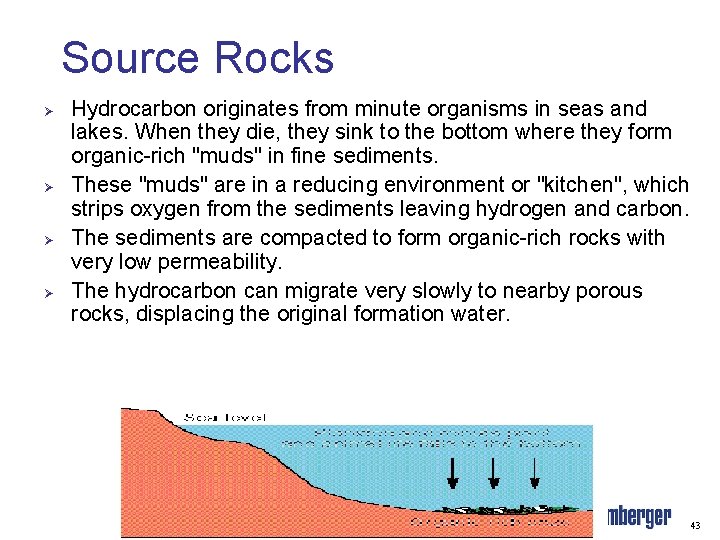
Source Rocks Ø Ø Hydrocarbon originates from minute organisms in seas and lakes. When they die, they sink to the bottom where they form organic-rich "muds" in fine sediments. These "muds" are in a reducing environment or "kitchen", which strips oxygen from the sediments leaving hydrogen and carbon. The sediments are compacted to form organic-rich rocks with very low permeability. The hydrocarbon can migrate very slowly to nearby porous rocks, displacing the original formation water. 43
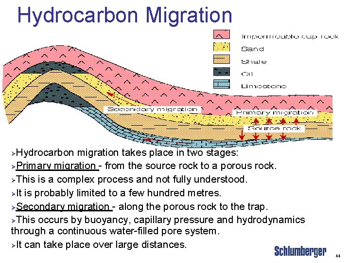
Hydrocarbon Migration Hydrocarbon migration takes place in two stages: ØPrimary migration - from the source rock to a porous rock. ØThis is a complex process and not fully understood. ØIt is probably limited to a few hundred metres. ØSecondary migration - along the porous rock to the trap. ØThis occurs by buoyancy, capillary pressure and hydrodynamics through a continuous water-filled pore system. ØIt can take place over large distances. Ø 44
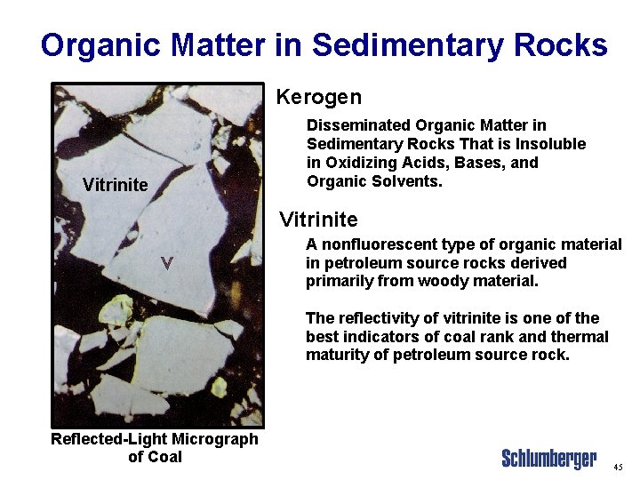
Organic Matter in Sedimentary Rocks Kerogen Vitrinite Disseminated Organic Matter in Sedimentary Rocks That is Insoluble in Oxidizing Acids, Bases, and Organic Solvents. Vitrinite A nonfluorescent type of organic material in petroleum source rocks derived primarily from woody material. The reflectivity of vitrinite is one of the best indicators of coal rank and thermal maturity of petroleum source rock. Reflected-Light Micrograph of Coal 45
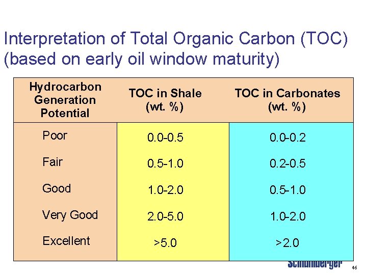
Interpretation of Total Organic Carbon (TOC) (based on early oil window maturity) Hydrocarbon Generation Potential TOC in Shale (wt. %) TOC in Carbonates (wt. %) Poor 0. 0 -0. 5 0. 0 -0. 2 Fair 0. 5 -1. 0 0. 2 -0. 5 Good 1. 0 -2. 0 0. 5 -1. 0 Very Good 2. 0 -5. 0 1. 0 -2. 0 >5. 0 >2. 0 Excellent 46

Plate Tectonics and Structural Geology 47

Elements of Plate Tectonics DIVERGENT BOUNDARY Mid-ocean ridge CONVERGENT BOUNDARY Plate subduction Sea floor spreading Lithosphere Oceanic crust Volcanism Mountain building Continental crust Deep-sea trench Litho sphe re Magma rising Asthenosphere Magma forming • Earthquake centers 48

Sedimentary Basin and Stress Fields Basin Geometries Fault Types Rift Related Basin (Extensional Stress) Normal fault Sedimentary Fill Foreland Basin (Compressive Stress) Thrust fault Pull-apart Basin (Lateral Stress) Wrench fault 49

Structural Features 50
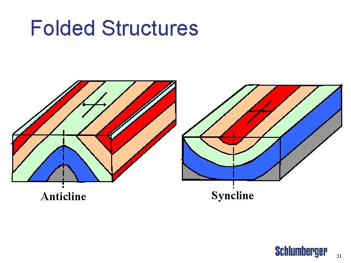
Folded Structures Anticline Syncline 51
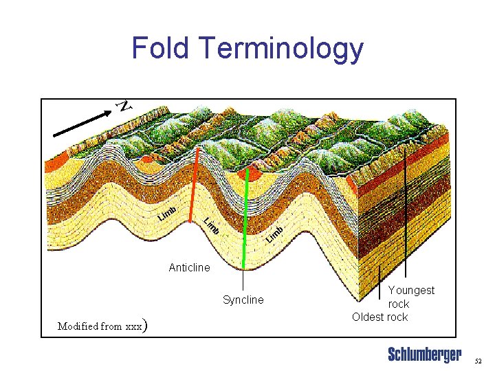
Fold Terminology N b Li m Li b m i L Anticline Syncline Modified from xxx) Youngest rock Oldest rock 52
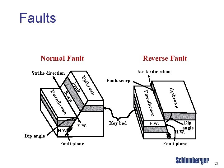
Faults Normal Fault Reverse Fault Strike direction own n Dip angle H. W. Fault plane Key bed F. W. rown nthr ow F. W. Upth n Dow ow p ar Sc thr wn Do ult Fa thr Up Fault scarp Dip angle H. W. Fault plane 53
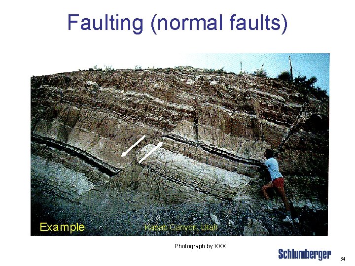
Faulting (normal faults) Example Kabab Canyon, Utah Photograph by XXX 54
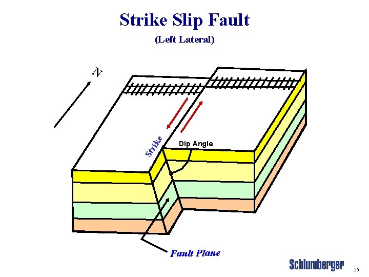
Strike Slip Fault (Left Lateral) Str i ke N Dip Angle Fault Plane 55

Heterogeneity 56
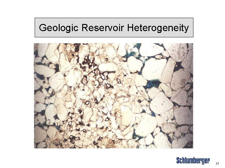
Geologic Reservoir Heterogeneity 57
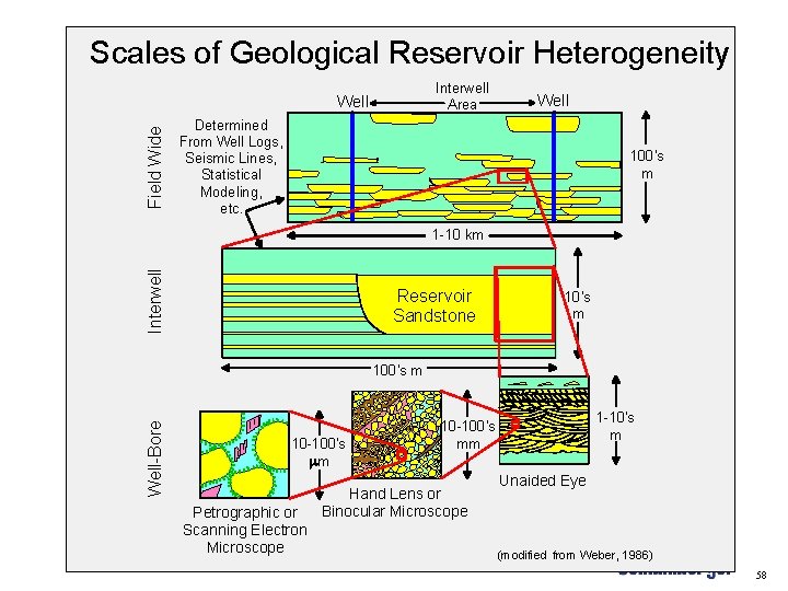
Scales of Geological Reservoir Heterogeneity Interwell Area Field Wide Well Determined From Well Logs, Seismic Lines, Statistical Modeling, etc. 100's m Interwell 1 -10 km Reservoir Sandstone 10's m Well-Bore 100's m 10 -100's mm Petrographic or Scanning Electron Microscope 1 -10's m 10 -100's mm Hand Lens or Binocular Microscope Unaided Eye (modified from Weber, 1986) 58

Hydrocarbon Traps Ø Structural traps Ø Stratigraphic traps Ø Combination traps 59
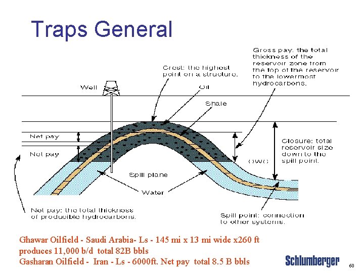
Traps General Ghawar Oilfield - Saudi Arabia- Ls - 145 mi x 13 mi wide x 260 ft produces 11, 000 b/d total 82 B bbls Gasharan Oilfield - Iran - Ls - 6000 ft. Net pay total 8. 5 B bbls 60
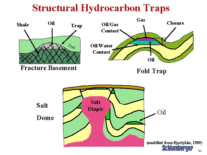
Structural Hydrocarbon Traps Shale Oil Trap Sea l Oil/Gas Contact Gas Closure Oil/Water Contact Oil Fracture Basement Salt Dome Fold Trap Salt Diapir Oil (modified from Bjorlykke, 1989) 61
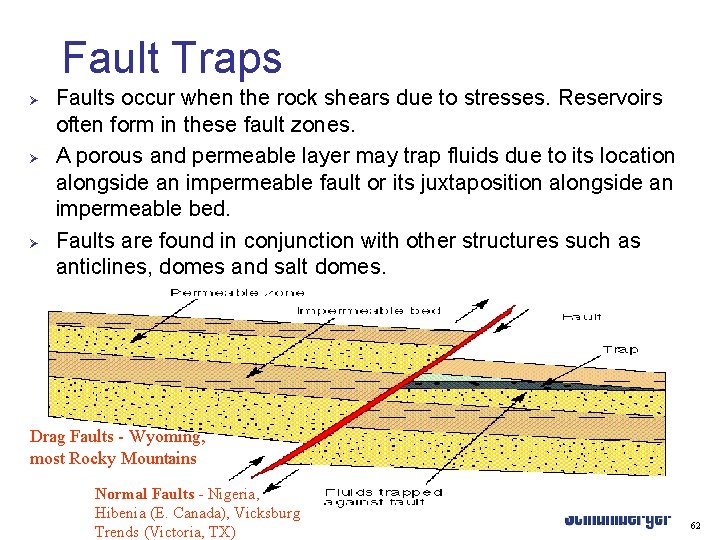
Fault Traps Ø Ø Ø Faults occur when the rock shears due to stresses. Reservoirs often form in these fault zones. A porous and permeable layer may trap fluids due to its location alongside an impermeable fault or its juxtaposition alongside an impermeable bed. Faults are found in conjunction with other structures such as anticlines, domes and salt domes. Drag Faults - Wyoming, most Rocky Mountains Normal Faults - Nigeria, Hibenia (E. Canada), Vicksburg Trends (Victoria, TX) 62
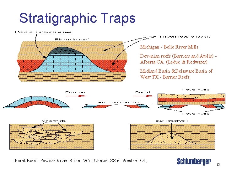
Stratigraphic Traps Michigan - Belle River Mills Devonian reefs (Barriers and Atolls) Alberta CA. (Leduc & Redwater) Midland Basin &Delaware Basin of West TX - Barrier Reefs Point Bars - Powder River Basin, WY, Clinton SS in Western Ok, 63
Petroleum Exploration: Geophysical Application to Petroleum Geology 64
Petroleum Exploration. Geophysical Methods Ø Gravity methods Ø Magnetic surveys Ø Seismic surveys 65
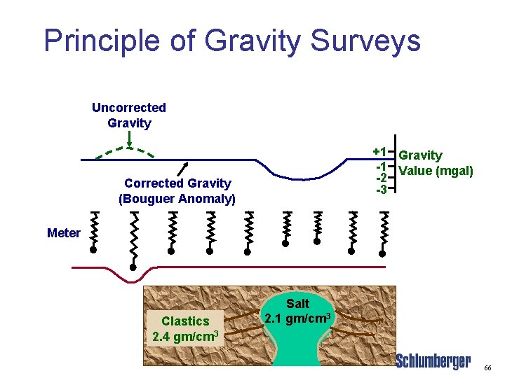
Principle of Gravity Surveys Uncorrected Gravity +1 Gravity -1 Value (mgal) -2 -3 Corrected Gravity (Bouguer Anomaly) Meter Clastics 2. 4 gm/cm 3 Salt 2. 1 gm/cm 3 66
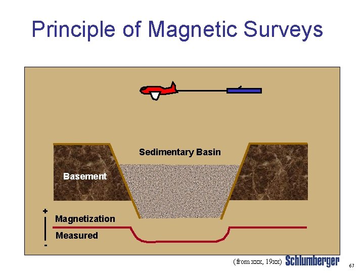
Principle of Magnetic Surveys Sedimentary Basin Basement + - Magnetization Measured (from xxx, 19 xx) 67
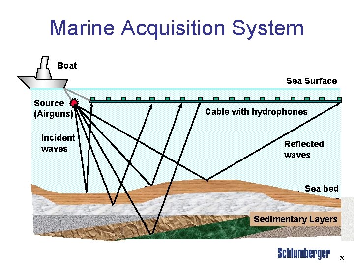
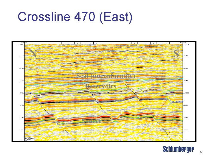
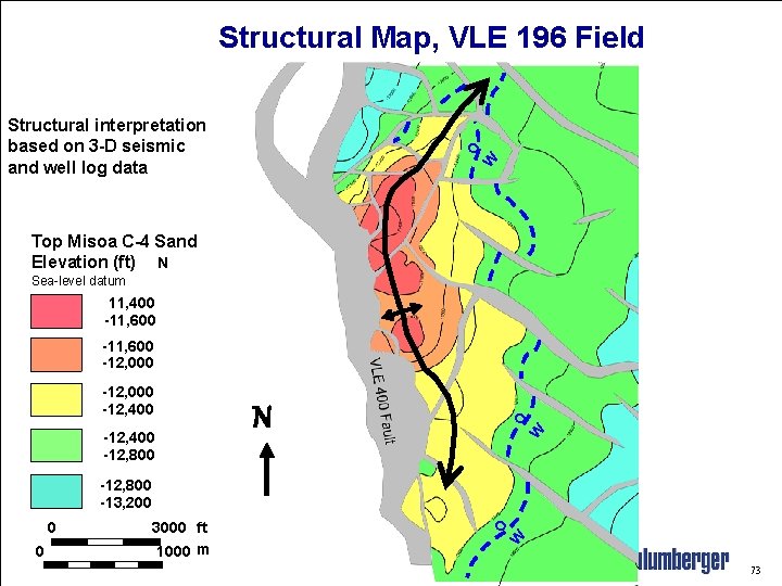
Seismic Surveys Ø Ø The seismic tools commonly used in the oil and gas industry are 2 -D and 3 -D seismic data Seismic data are used to: – Define and map structural folds and faults – Identify stratigraphic variations and map sedimentary facies – Infer the presence of hydrocarbons 68
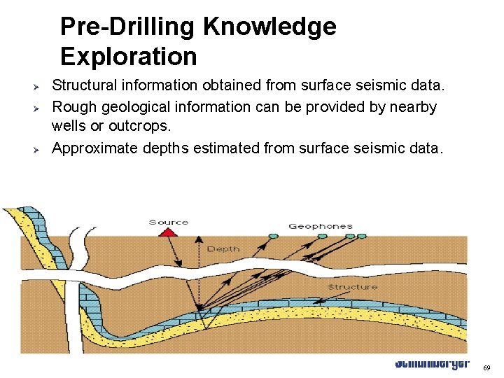
Pre-Drilling Knowledge Exploration Ø Ø Ø Structural information obtained from surface seismic data. Rough geological information can be provided by nearby wells or outcrops. Approximate depths estimated from surface seismic data. 69
Marine Acquisition System Boat Sea Surface Source (Airguns) Incident waves Cable with hydrophones Reflected waves Sea bed Sedimentary Layers 70
Crossline 470 (East) N S Seal (unconformity) Reservoirs Source 71
Applications of Seismic Data Ø Ø Ø Make a structural model of the reservoir Delineate and map reservoir-quality rocks Establish gas/water contacts 72
Structural Map, VLE 196 Field W O Structural interpretation based on 3 -D seismic and well log data Top Misoa C-4 Sand Elevation (ft) N Sea-level datum 11, 400 -11, 600 -12, 000 W -12, 400 -12, 800 N O -12, 000 -12, 400 0 3000 ft 1000 m W 0 O -12, 800 -13, 200 73
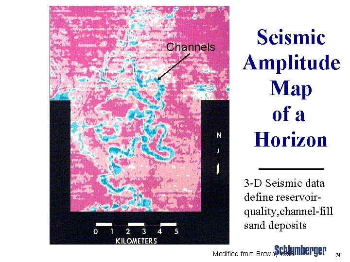
Channels Seismic Amplitude Map of a Horizon 3 -D Seismic data define reservoirquality, channel-fill sand deposits Modified from Brown, 1996 74
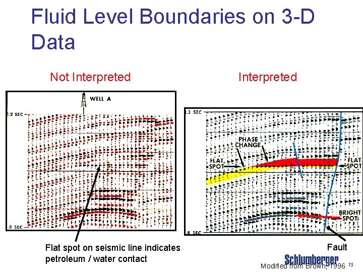
Fluid Level Boundaries on 3 -D Data Not Interpreted Flat spot on seismic line indicates petroleum / water contact Interpreted Fault Modified from Brown, 1996 75
4 -D Seismic Surveys Ø Ø The “ 4” in 4 -D seismic is time A 4 -D survey means that at least two 3 -D seismic surveys have been made at different times over the same field Reflection character (attributes) change through time These changes result from migration of the water contact in the reservoir 76
Importance to Schlumberger Ø Ø Source of revenue. Allows our Engineers to: • • Better understand the limitations of a reservoir. Design better treatments 77
STS 51 C-143 -0027 Mississippi River Delta and Coastal Louisiana, U. S. A. January 1985 NASA PHOTO 78
STS 61 A-42 -0051 Mississippi River Delta, Louisiana, U. S. A. October 1985 N 20 mi NASA PHOTO 79
Exercises: Petroleum Geology 80
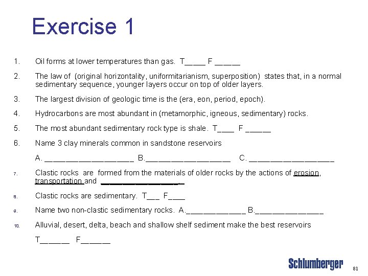
Exercise 1 1. Oil forms at lower temperatures than gas. T_____ F ______ 2. The law of (original horizontality, uniformitarianism, superposition) states that, in a normal sedimentary sequence, younger layers occur on top of older layers. 3. The largest division of geologic time is the (era, eon, period, epoch). 4. Hydrocarbons are most abundant in (metamorphic, igneous, sedimentary) rocks. 5. The most abundant sedimentary rock type is shale. T____ F ______ 6. Name 3 clay minerals common in sandstone reservoirs A. ___________ B. __________ 7. C. __________ Clastic rocks are formed from the materials of older rocks by the actions of erosion, transportation and _________. 8. Clastic rocks are sedimentary. T___ F____ 9. Name two non-clastic sedimentary rocks. A. _______ B. ________ 10. Alluvial, desert, delta, beach and shallow shelf sediment make the best reservoirs T_______ F_______ 81
Exercise 2 1. Diagenesis is the chemical alteration of a rock after burial. T___ F ___ 2. (Magnesium, Iron, or Sulfate) must be in the formation water in order to convert limestone to dolomite. 3. Limestone is (Ca. CO 3 or Ca(CO 3)2). 4. Dolomite is Mg. Ca. CO 3 or Mg. Ca(CO 3)2. 5. Reef deposits are classified as (clastic, carbonate) sedimentary rocks. 6. The source rock must contain (organic material, coal, methane). 7. Fault and anticline traps occur only in gas wells. T___ F___ 8. The oil water contact can be observed using seismic T___ F___ 9. (Historical, structural, tectonic) geology addresses the occurrence and origin of smaller scale deformational features, such as folds and faults, that may be involved in hydrocarbon migration or which may form structural hydrocarbon traps. 10. Good quality sandstone reservoirs normally contain ~ (1 -10 or 25 -30% silt and clay). 82
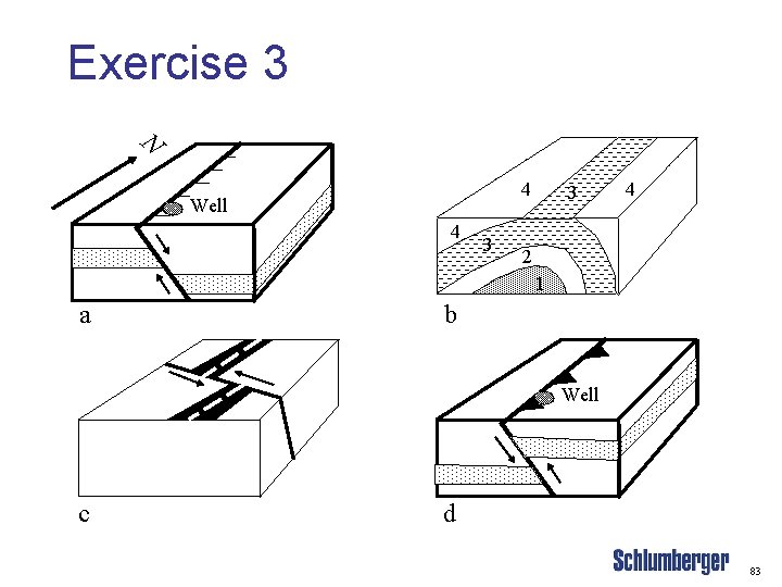
Exercise 3 N 4 Well 4 3 3 4 2 1 a b Well c d 83
Exercise 4 1. 2. 3. 3. 4. 5. Hydrocarbons reservoirs are normally in (igneous, metamorphic, sedimentary) rocks. Fluorescence of drill cuttings or core indicates (oil, gas, water) is present. Reservoir traps are (very impermeable, highly permeable). What are 2 uses of seismic data in petroleum exploration and development? 1. ________________________ 2. _________________________ In inclined reservoir rocks, what is the significance of a “flat spot” in seismic sections? What is a 4 -D seismic evaluation? 84
- Slides: 84