ALevel Geography Managing the NEA for success Reflections


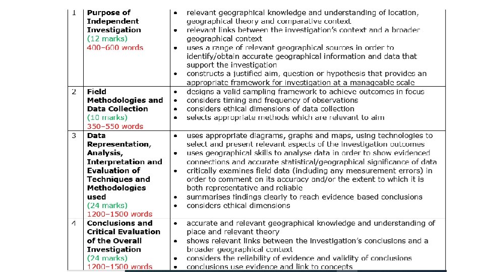


 to finalise their survey and")


- Slides: 42
A-Level Geography Managing the NEA for success: Reflections, tools and ideas Simon Holland CGeog FRGS Course Leader for Geography at Bilborough College Chris Collins Head of Faculty for Geography and Biology at Bilborough College Follow us on Twitter and Instagram @Bilbo. Geog Reflecting on the first three A-Level cohorts and discussing ways to develop practice. We will explore powerful tools and strategies to support students in completing successful NEAs including GIS and Survey 1, 2, 3. Experiences, ideas and resources will be shared to help support teachers and students with this vital part of A-Level. WELCOME EVERYONE! We have done our best to adapt to the e. Conference environment, we hope you find it useful!
Introductory Poll and Discussion • How much experience of the new NEA to do you have? 1. This is my first time running the new NEA 2. I have run it once. 3. I have run it every year since the new spec came in. • What do you like about running the NEA with students? • What are your main concerns about running the NEA?
A-Level Geography Managing the NEA for success: Reflections, tools and ideas PART 1: Reflections and Successful Management of the NEA Chris Collins Head of Faculty for Geography and Biology at Bilborough College Follow us on Twitter and Instagram @Bilbo. Geog
Getting Started – Start Local and Link to Specification What evidence is there for the need for regeneration in your chosen local area? (20 Marks) 1. BUGS THE QUESTION 2. Define REGENERATION in title. Introduce local area as Bilborough – 1932 council estate extended in 1950 s , Acorn Profile low , Primary and Secondary 3. Secondary data Quantitative e. g. Census 41% no formal qualifications England average 22. 5%, , 58 % good health compared to 68% in England , 7% unemployed compared to 4. 4% in England. IMD 627 on 4, 760 in Bilborough , Bracebridge Drive 627 and College Way 25, 380 out of 32, 844 – HIGHEST IS LEAST DEPRIVED ON THIS SCALE , LOWEST IS MOST DEPRIVED , Police – crime above average , Nottingham Post and Social Media Qualitative “full and coherent interpretation that is supported by evidence. ” (AO 2). Primary data / Fieldwork Qualitative – Environmental Quality Survey , Index of Decay and Placecheck form. What were your MAIN findings? How was College Way different to Hanslope Crescent? Are both areas in NEED of regeneration? • 6 CONCLUSION – Answer the question. Do YOU think that it needs to be regenerated? – SUMMARISE main findings and make the case. Which is the best data Quantitative /Qualitative “ substantiated conclusion, fully supported by a balanced argument”
Use resources that are available to you
Use the ‘Discovery Worksheet’ to help create a focused question to share with the class. https: //qualifications. pearson. com/content/d am/pdf/A%20 Level/Geography/2016/teachi ng-and-learning-materials/Fieldwork. Planner-and-Guide. pdf
https: //www. rgs. org/schools/teachingresources/a-student-guide-to-the-alevel-independent-investi/
Where to start? The NEA has to be based on the Key ideas and detailed content shown in the A level specification. There are three Topics that you could choose from… Topic 4: Shaping places Topic 5: The water cycle Topic 6: The carbon cycle 1. Read the overview and detailed content for Topics 4, 5 and 6. 2. Identify the Key ideas and content you think you might be interested in investigating. 3. Complete this table to help you organise your ideas…
What aspects of the Topics could I investigate? Themes Option 4 a Regenerating Place Themes Topic 6 Carbon Cycle Changing Place Marginalisation of place Changing functions of cities Economic change Social inequality Making place and marketing image Agents of change: Perception and Conflict Example questions: Has regeneration in Plymouth been successful? Carbon stores Carbon sequestration Impacts of climate change on the carbon cycle Impacts of land use change on the carbon cycle Links between human wellbeing and changes in the carbon cycle Adaptation to a changing climate Example question: How does x land use impact carbon storage? How has the changing economy in the South Hams influenced the services present? Themes Topic 5 Water Cycle and water Insecurity Inputs and outputs Stores and flows Drainage basin Impact of physical and human characteristics of the drainage basin Causes of flooding and increasing flood risk Impacts of flooding Example question: What impacts does urbanisation have on a drainage basin?
Identifying a focus and drafting ideas for a title. Topic Key idea Draft title Detailed content What could I investigate
Devising your title. Once you have identified the Key idea and detailed content you want to investigate, you will need to write your NEA title. Writing a good quality title is VITAL (as a poor title usually leads to a poor NEA). The title needs to be something you will be interested in; something you will learn from investigating; have a specific focus; and be of a manageable scape. • What about these as possible tiles? : • “Regeneration in South Shropshire” • “Has Telford`s regeneration been good or bad? ” • What did Church Stretton do to regenerate its economy? • better titles would be: • To what extent has the tourist based regeneration of (name a place) been a success? • To what extent has small scale regeneration been successful in regenerating the wider community in (name a place)? • An evaluation of the sustainability of tourist based regeneration in rural areas: The case of (name a place) • To what extent is the perception of regeneration influenced by social and economic well being in (name a place)? Now have a go at drafting some possible titles.
Working out a tile for your NEA. Once you have devised what you think would be a good title, consider whether it is SMART S M A R T Your title needs to be… Specific to a Key idea and detailed content of the specification Manageable in terms of scale Achievable in terms of data Realistic in the terms of time Taking the subject further – learning something that you do not already know Once you have a SMART working title, you need to break up the title into smaller aims (this could be social, economic and environmental). The individual aims are what you will investigate in order to collect evidence to help you answer/discuss the title.
Curriculum Press Geo Factsheets https: //curriculum-press. co. uk/resources/secondary/geography/a-levelgeography? category. Topic%5 B%5 D=fieldwork-and-the-nea
Curriculum Press Geo Factsheet Literature Review – introduce these throughout the course when studying topics • Citing from a wide range of sources, a Literature Review should aim to: • Show what is already known about your topic by geographers • Show any models or theories in relation to your topic • Show where gaps in the existing geographical knowledge occur (and how your study aims to fill them) • Suggest why it is important to study this particular topic
Examples of Models and theories used in Geography Relating the NEA aims to existing models and theories will help you to place your investigation into a context, both in terms of geography and place. It will help to show your investigation improves our understanding of the subject. These are some examples of models and theories we refer to in regeneration Geography. Place regeneration Rural-Urban continuum (Pg 216) Sectoral change (Pg 217) Egan model od sustainable communities Core-Periphery model Dynamism (Pg 216) Cycle of Poverty Gentrification (Pg 225) Glasgow effect (Pg 221) Filtering (Pg 226) Burgess model Rostow model Location quotient (Pg 219) Deindustrialisation (Pg 219) Social segregation (Pg 223) Cycle of affluence Socio-economic group Clark-fisher model Groups involved with Regeneration, we call them `Players`… For example… Locals Planners Developers Pressure groups
Proposal Form – Encourage Detail
Edexcel Support Byker Wall Example
Royal Geographical Society NEA Guide – FREE DOWNLOAD: www. rgs. org/nea
Go through the Examiner reports / mark scheme with the students. This examiners report provides a useful checklist for the students.
Checklists – Change and adapt
Reminders: • We CANNOT mark your drafts or give you any specific personal feedback on your work. YOU must take the initiative with this and work out from the GENERIC support how to improve. We are very limited in the support we can offer you individually – sorry about this! • Your NEA MUST BE ENTIRELY YOUR OWN WORK, so no parental/ sibling/friend/web forums help etc. (apart from group/share collection of some primary data only). All other reading/facts/work used MUST be fully referenced and in your bibliography to avoid plagiarism which is serious misconduct. • The coursework is VITAL and is worth 20% of your final mark – likely to equate to at least 1 or 2 final exam grades and vital to passing the course! • You can make a real difference with your coursework and failure to complete it on time will be taken very seriously.
A-Level Geography Managing the NEA for success: Reflections, tools and ideas PART 2: Tools, ideas and using GIS to help manage the NEA Successfully Simon Holland CGeog FRGS Course Leader for Geography at Bilborough College Follow us on Twitter and Instagram @Bilbo. Geog
Quick Poll • How confident are you at using GIS to support the NEA? 1. Really unsure, don’t really know how. 2. Have some idea but am not really confident. 3. Very confident. • What is the main barrier to you using GIS more widely as part of the NEA data collection? 1. Not having access to the technology needed. 2. My own confidence/understanding. 3. Lack of student competence/time to train them up.
How we manage our large cohorts doing the NEA with very successful outcomes • We are a large centre with around 70 to 90 candidates in each year group. • As such managing the NEA posed a challenge, especially with the need for all students to devise and carry out their own individual and independent study with a different title. • In terms of managing the fieldwork we decided from the start to use Arc. GIS Online to help manage the data collection and support high quality analysis and it has proven to be a very useful tool. • Despite what you might think, its actually quite easy to pick up as a teacher and students seem to find it really user friendly which is great.
Using Arc. GIS Online and Survey 1, 2, 3 to Manage the NEA Successfully • Arc. GIS Online is now free to all schools and colleges and is an excellent teaching resource that really helps bring data to life and develop great employability skills. https: //schools. esriuk. com/ • For the NEA we use one of the free Apps that works with Arc. GIS Online – Survey 123. • This is free to download to students own phones/tablets from the usual App stores. They then sign in with the Arc. GIS Online accounts you set up for them (this can be done quickly as a bulk upload – see https: //schools. esriuk. com/teaching-resources). • Students then create their surveys and data collection forms by signing in at https: //survey 123. arcgis. com/. • The forms they create are then downloaded into the app. After this they can collect data offline and sync the next time they have data or wifi access.
• Survey 123 when students login online allows them to build a survey or data collection form really easily and quickly, independently by clicking the +Create a New Survey button at the top.
• Always use the web designer as its much simpler!
• Always use the web designer as its much simpler
• Students simply fill in their survey title and some ‘tags’ to make it easier to find later – student names are a good tag though this is recorded from their login too. • Summary can be left blank – next click create!
• Then students add their questions step by clicking on the options on the right hand side – worth explaining and demonstrating these question types to students as a dry run beforehand or on other more teacher-led mini-fieldwork.
• Once complete, students must click ‘Publish’ (twice) to finalise their survey and make it ready for use. • After a short processing delay it will be ready for use!
• Finally if you click ‘Collaborate’ at the top you can get the link to share the survey if needed (or a QR code) AND choose if you want to enable others in your organisation or the wider public to collect data. Useful for group data collection or email surveys etc.
• Please go to https: //arcg. is/1 GOGy. W if you can in another tab or on a mobile and complete the short example survey I just made in seconds whilst I run through a few other bits and bobs. The above QR code should work also if you would rather scan with your phone. • Students who have signed into the Survey 123 App on their phones will find that the survey will automatically sync into their app ready for them to collect data as soon as they open the app. It then works offline to collect data if in a remote area and syncs the data for analysis when back on data/Wifi. • I will now show you briefly some of the simple analysis tools available to students and then hopefully look at some of your response data if it works!
• As soon as the data is synced by opening the app on wifi or mobile data, the data is available for analysis when they log in to Survey 123 online, download to excel or display and analysis immediately in Arc. GIS online. • When you click the ‘Analyze’ tab you can quickly present your data in a range of graphs, maps, tables and diagrams to get you started. Useful for pilot studies too.
• Some examples of the output of results. • Clearly students need to think carefully about whether these are the right kind of graphs and how the data could be better analysed/synthesised. • All of the data can be easily downloaded to excel or shared using the ‘Data’ tab.
• Also under the ‘Data’ tab you can instantly map your data sets and access a simple map viewer GIS system which is great for simple GIS analysis. • However much stronger analysis can be completed by logging in at www. arcgis. com – collected data will show up as one of your layers immediately enabling strong GIS analysis – use the great tutorials and student self help sheets available at https: //schools. esriuk. com/teaching-resources to help.
Strengths üThis is a much easier tool to use than you would think, its intuitive and easy to set up, students seem to find it easy to use and make great use of it. There is a lot of useful support materials on the site and on You. Tube and you can always contact their excellent staff @GIS 4 Schools for help. üThe paperless, secure and instantly backed up/processed data is much easier (and cheaper!) to manage from a teacher perspective and you can see what they have been doing by logging in with a staff account. üData collected and shared is available as a secondary dataset for any future studies in a similar area. üSimply doing it on a phone really helps engage some students and allows them to use other phones apps alongside (sound meters, tree id apps etc). üThe fact that everything is already in excel and Arc. GIS online means they are much more likely to think carefully and create great analysis approaches. üThere a lot of HE and Employability skills here so it is great for careers.
Things to Consider Some students tend to rely heavily on the auto-generated word clouds and graphs even if these are not the best way of analysing data. Students need powerpacks to ensure they have charged up phones that don’t die all of a sudden – usually they have this covered!! You need to train the students in how to do the analysis and use the system before the NEA as your support afterwards is clearly constrained. Although it is quite straightforward you do need to invest a little time training yourself up on the system using the materials and tutorials out there as well as setting up student accounts etc. Some students need more support than others and physical geography projects can use Survey 123 (data boxes as questions) but you might be better researching other ESRI free tools like Arc. GIS collector as you get more confident.
Useful Arc. GIS links • Most of what you need to sign up and get help are freely available on the https: //schools. esriuk. com/ site including training and full lesson plans. • A great resource to help you get started with Survey 1, 2, 3 https: //learn. arcgis. com/en/paths/developing-knowledge-skills-andconfidence-with-survey 123/ • Great storymaps on GIS and the NEA: https: //arcg. is/Xf. Waj and Fieldwork: https: //arcg. is/1 WPfja there are loads more on the above Schools site. • ESRI UK Education Staff are great if you get really stuck or have technical questions contact Jason and the team via Twitter www. twitter. com/@GIS 4 Schools
A-Level Geography Managing the NEA for success: Reflections, tools and ideas Simon Holland Chris Collins Follow us on Twitter and Instagram @Bilbo. Geog THANKS for your time, we really hope you found the session useful. Please get in touch via @Bilbogeog on Twitter if you have any questions and keep up the great work – the NEA can be a wonderful experience for students and staff alike if carefully managed!