Using GIS to Automate Sanitary Surveys Genesee County


- Slides: 48
Using GIS to Automate Sanitary Surveys Genesee County Health Department Environmental Division Orleans County Public Health
Background - Greater Rochester Health Foundation Grant RFP released December 2007 Non-competitive grants to 8 rural counties surrounding Monroe Focus to address health needs of communities outside Monroe County Collaborative approach between Genesee and Orleans with focus on GIS initiative
Background – Continued Utilized Lake Plains Community Care Network to Administer Grant Awarded grant $330, 000 over 3 years Purpose of grant to develop a database of GPS points for well and septic system components within the two counties
Relevant County Data In Genesee County 40% or 9, 634 households served by wells 48% or 11, 588 households served by private septic systems In Orleans County 35% households - private Wells 60% households – private septic
Project focus - Promotion of Public Health Rural Health Issue Opportunity to Leverage Technology Collecting GPS data helps to speed up the response to well contamination events Provides surveillance data that allows us to see problems developing
Project Focus - Other Enhanced Benefits • Streamline office processes and work flows • Create Virtual files • Reduce FTE time – Inspector – Support staff
Project Basics - Water Sources Some home owners make use of hand dug wells and cisterns These sources seen as at a higher risk than drilled wells for potential contamination Reality is any on site well can be subject to contamination
Routes of Contamination • Land spreading of manure and • • • pesticides Aging and failing septic systems Chemical spills, traffic accidents, railroad accidents Lack of maintenance
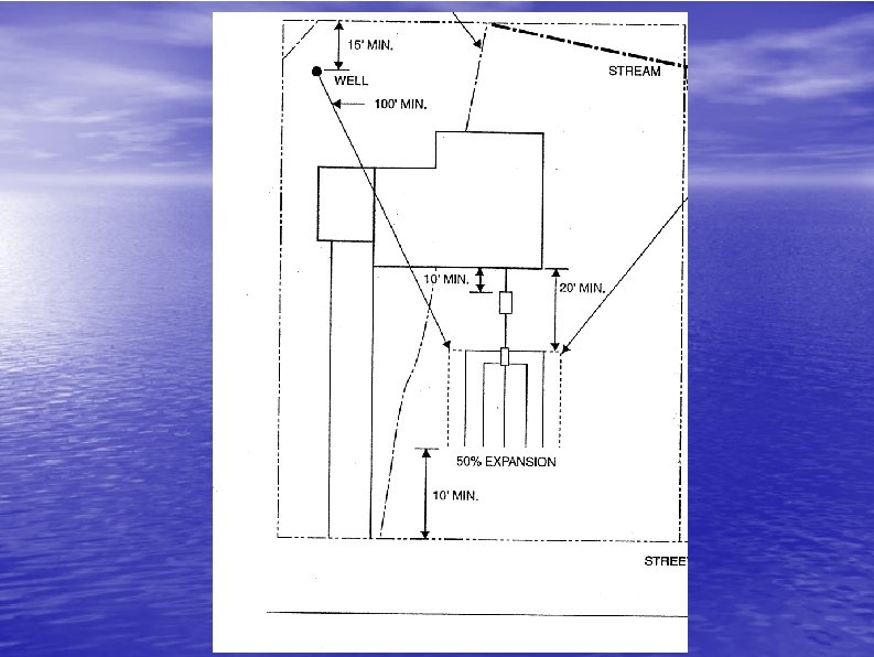
Leach Field Design Considerations Separation distances to wells, surface water bodies Separation distances to bed rock or the water table Adequate length of trenches for proper treatment
The Old Process
Requests for Inspections Sale of home, if required by lending agency Complaint of water quality or failing septic system Illness or widespread contamination events Construction of new septic systems
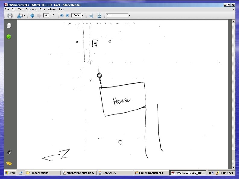
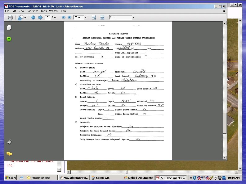
Field Visit Conducted • Inspector arrives on site and records observations and site specific data onto paper forms • Identifies public health hazards and violations, recommends corrective procedures.
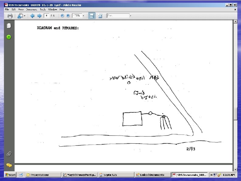
Identified Inefficiencies • • • Hand drawn sketches often lacking in detail Files stored in cabinets creating limited accessibility for studies or investigations – Response to contamination events requires digging through files for data, and some events full extent could be overlooked Inspector only generally carries one property's historical data to an inspection – Limits ability to detect neighborhood issues
The New Process
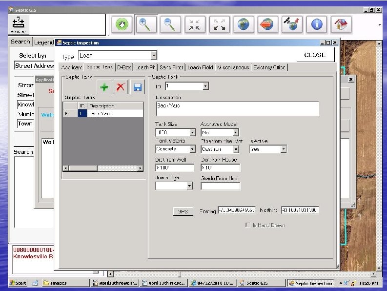
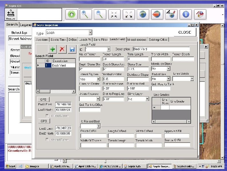
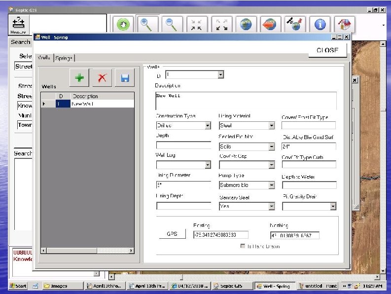
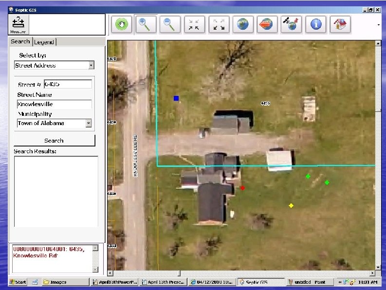
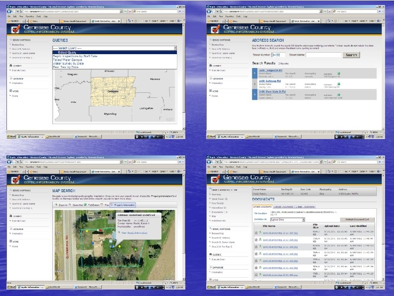
The New Process GIS used to automate the processing of data and storing that data in an easy to use form Inspectors given a laptop with the application installed and a Trimble GPS unit
Inspection Conducted Inspector loads up the application and finds the property location that they're inspecting Inspector fills out the forms for each component of the septic system and well
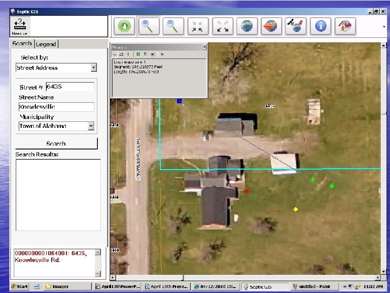
• Measuring tool allows measurement of features, separation distances, areas of leach fields
• Navigation tools allow for pan movement around the map, custom zoom, fixed zoom, and zoom to full extent of the map.
• Zoom to GPS: Zooms map to current location of Trimble GPS unit. Removes need to manually search for your location on the map
• Parcel tools allow for identification of map layer features, opening an inspection report, selecting/deselecting parcels on the map
• Opens the file linker for the selected parcel, allowing for the viewing of historical scanned documents
• Synch button synchs the laptop with the main database
File Linking Historical paper records are being scanned into PDF documents Gives the inspector the entire data base of information at their fingertips, dating back into the 1950's
Synchronization Each laptop is synched in the morning and at the end of the day Ensures that each laptop has a complete data base when brought out into the field
Desktop Application
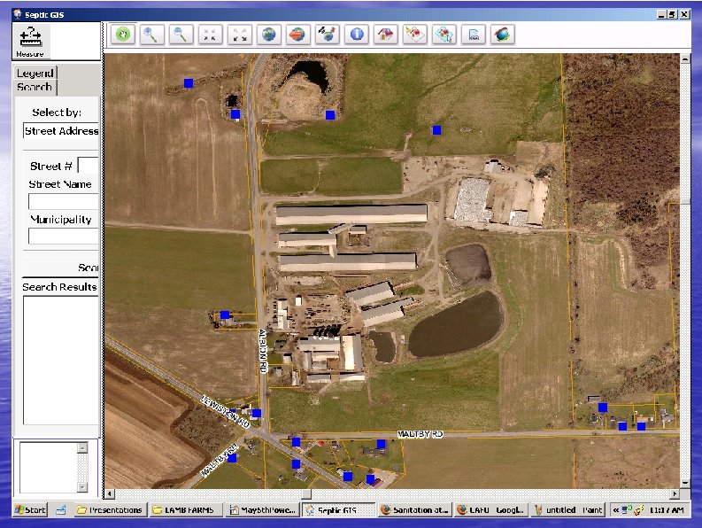
New GIS System In Action Lamb Farms in Genesee County
Lamb Farms • Concentrated Animal Feeding Operation • • • located in Oakfield 2, 400 Cows involved in the milking operation Producing 45 million gallons of manure per year Stored in an on-site 15 million gallon lagoon and spread onto fields as fertilizer
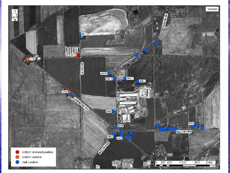
Threat Identified • Notified by NYDEC and USEPA of high levels of nitrates in wells serving the farm • Sampling in August of 2008 showed nitrate levels from 17 – 25 mg/l in the Farm's Wells
Public Health Response • Farm notified and placed on increased monitoring as a public water supply • Sampling for coliform/E. Coli and Nitrate expanded to nearby residents to determine extent of contamination
Resolution • Town of Oakfield applies and is awarded a grant to expand public water to the affected area • Oakfield Water District #2 has been constructioned to serve the population nearby Lamb Farms
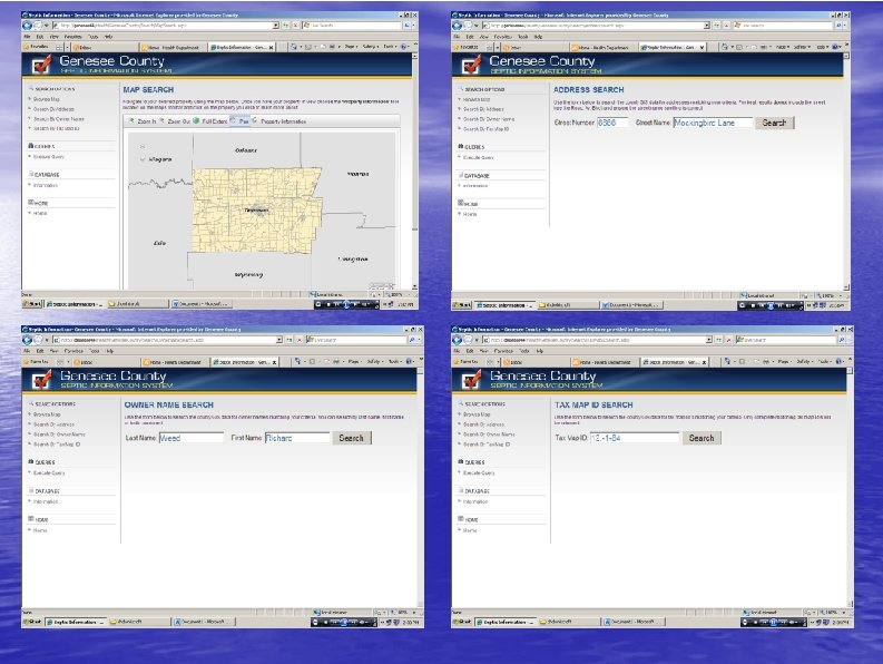
The Benefits of the new Methodology Increased ability to see potential public health problems before they start Archiving of Historical Data Inspector carries the entire data base of information and gains insight Less paperwork and hunting for paper work in the office Web based applications
Acknowledgements • Greater Rochester Health Foundation and Lake Plains for issuing and administering the grant • Eric Brady and Bergmann Associates for development of the GIS Application