UNIT II SITE ANALYSIS Importance of site analysis


- Slides: 53
UNIT II SITE ANALYSIS Importance of site analysis - factors involved – On site and off site factors; Analysis of natural, cultural and aesthetic factors – topography, hydrology, soils, vegetation, climate, surface drainage, accessibility, size and shape, infrastructures available - sources of water supply and means of disposal system, visual aspects;
Site Analysis is the process of surveying or studying the existing environment and how it will influence the structure’s design and layout on the site.
The secret of using the site analysis is to design a good relationship between the building and the site itself. The building design should be in harmony with those beneficial site conditions and strive to save, reinforce, amplify, and improve on what is existing. The Analysis will identify those site conditions which may be altered, eliminated, covered up, disguised or reformed. It is important to make these decisions deliberately and thoughtfully so that the effects of the building on the site are deliberate rather than accidental or incidental.
All the factors needed for a complete site analysis can generally be categorized into Aesthetic, cultural, and natural forces. AESTHETICS has to do with what the person who will live on the site thinks is beautiful (the designer has the responsibility to educate the client to possibilities); CULTURE is the background of the people living in the area; and the NATURAL factors are the background of the environmental elements. For Energy-efficient Design, natural factors need to be investigated and understood. The natural factors which are most important for thermal comfort in this analysis can be listed under climate and microclimate.
SITE SELECTION • For every site there is an ideal use • For every use there is an ideal site SITE ANALYSIS involves the study of the site in terms of the following : (What are factors influencing site planning? ) Natural factors : 1. Geology 2. Geomorphology – physiography, landforms, soils, drainage, topography and slopes, and soil erosion 3. Hydrology – surface and ground water 4. Vegetation – plant ecology 5. Wildlife – habitats 6. Climate – solar orientation, wind, and humidity.
Cultural factors : 1. Existing land use – ownership of adjacent property, offsite nuisances 2. Traffic and transit – vehicular and pedestrian circulation on or adjacent to site 3. Density and zoning – legal and regulatory controls 4. Socio-economic factors 5. Utilities – sanitary, storm-water, water supply, power supply, and communications. 6. Historic factors – historic buildings, landmarks, and archeology
Aesthetic factors : 1. Natural features 2. Spatial patterns – spaces and sequences 3. Visual Resources – views and vistas The categories of data and its interpretation is related to the proposed project. The level of detail depends on the nature of the program -- how simple or complex and the type of site -- rural or urban
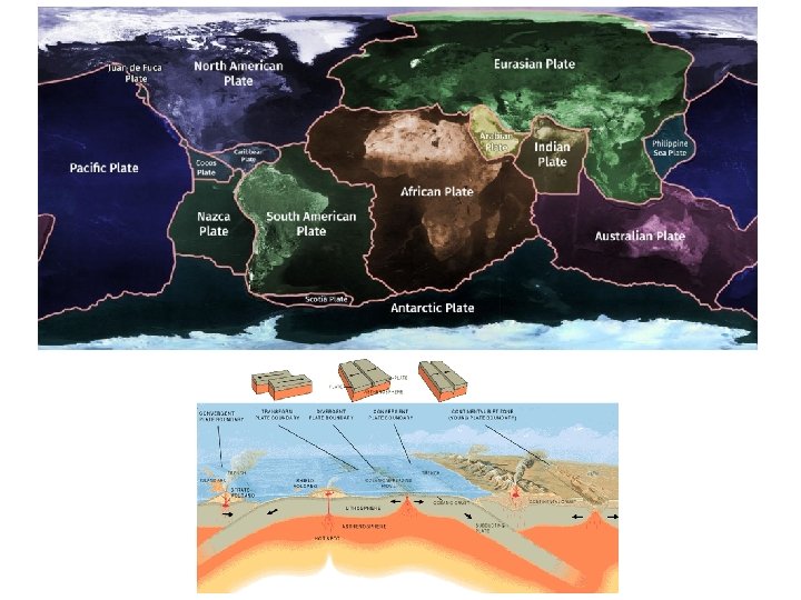
NATURAL FACTORS : GEOLOGY is the natural science that studies the Earth – its composition; the processes that shaped its surface; and its history. Earth is made up of rocks (including soil, sand, silt and dust); rocks are composed of minerals; minerals are made up of atoms
Igneous Rocks – rocks produced by crystallization from a liquid.
Sedimentary Rocks – when igneous rocks are exposed to surface, weathering reduces them to particles, and are moved by erosional process and deposited in layers into rivers and oceans (Lithification).
Metamorphosed Rocks – when sedimentary rocks are pushed to deeper levels of the earth, they transform into metamorphosed rocks due to changes in pressure and temperature.
GEOMORPHOLOGY - is that branch of Geology that deals with the origin, nature and distribution of landforms. Physiography – refers to the description of landforms. Landforms – are irregularities on the earth’s surface. They are derived from volcanic, glacial, or erosion processes.
When designing a piece of property for architectural, landscape architectural and engineering usage, it is essential for the designer to first confront the nature of the land, particularly its form, its slopes, and its inherent capabilities for surface and subsurface discharge of water, for supporting vertical and horizontal structures, and for resisting erosion. This requires four basic geomorphologic information such as: 1. Soil Properties – Composition and Soil Texture 2. Drainage 3. Topography and Slopes 4. Soil Erosion
In site planning, it is important to establish the relationship between soil composition and land uses. Soil surveys help guide in site selection for residential, industrial, and other forms of development that involve surface and subsurface structures. Several features or properties used to describe soil for use in site design. Of these 1. COMPOSITION 2. TEXTURE from which we can make inferences about bearing capacity, internal drainage, erodibility, and slope stability.
SOIL PROPERTIES: COMPOSITION refers to the material that makes up soil: mineral particles, organic matter, water, and air. 1. Mineral Particles comprise 50% to 80% of the volume of the soil and form the all important skeletal structure of the soil. Sand gravel particles provide for the greatest stability, usually yield a relatively high bearing capacity, Bearing capacity is a soil’s resistance to penetration from a weighted object such as a building foundation.
2. Organic Matter varies radically in soils and usually imposes a limitation to any building structure. Organic matter is important only for soil fertility, moisture absorption and retention and for landscaping. 3. Water content varies with particle sizes, local drainage, topography and climate. Most water occupies the spaces between particles; only in organic soils do the particles themselves actually absorb measurable amounts of water. 4. Air is what occupies remaining space that is not occupied by water. In layers where groundwater is formed by gravity water in the subsoil and underlying rock, there is absence of air.
TEXTURE - is the term used to describe the composite sizes of particles in a soil sample. There are 12 basic terms for texture, at the centre of which is Class LOAM, which is an intermediate mixture of 40% sand, 40% silt and 20% clay.
DRAINAGE: GOOD DRAINAGE refers to the soil’s ability to transfer gravity water downward through: 1. Infiltration - the rate at which water penetrates the soil surface (usually measured in cm or inches per hour). 2. Permeability - the rate at which water within the soil moves through a given volume of material (also measured in cm or inches per hour). 3. Percolation - the rate at which water in a soil pit is taken up by the soil (used mainly in wastewater absorption tests and measured in inches per hour).
POOR DRAINAGE - means that gravity water is not readily transmitted by the soil and soil is frequently or permanently saturated and may have water standing on it caused by : 1. The local accumulation of water 2. A rise in the level of groundwater within the soil column 3. The size of the particles in the soil being too small to transmit infiltration water.
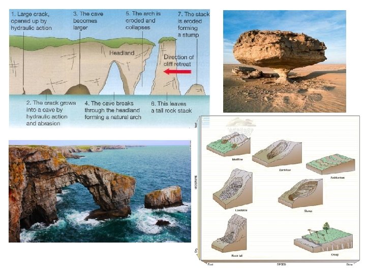
TOPOGRAPHY AND SLOPES SLOPE ANALYSIS - Understanding slope forms for site design requires understanding of local geologic, soil, hydrologic, and vegetative conditions. SLOPE FORM - is expressed graphically in terms of a slope profile, a silhouette of a slope drawn to known proportions with distance on the horizontal axis and elevation on the vertical axis Four basic slope forms are detectable on contour maps: STRAIGHT S - SHAPE CONCAVE CONVEX
TOPOGRAPHIC MAP – a map of a portion of the earth that describes the shape of the earth’s surface by contour lines.
Contours – are imaginary lines that join points of equal elevation on the surface of the land above or below a reference surface such as the mean sea level. Contours make it possible to measure the height of mountains, depth of the ocean bottoms, and steepness of slopes.
HYDROLOGY the natural science that studies the Waters of the Earth, their occurrence, circulation and distribution, their chemical and physical properties, and their reaction to the living environment including their relation to all living things. Hydrologic cycle – or the planet’s water cycle, described by the movement of water from the oceans to the atmosphere to the continents and back to the sea.
Water table – is the upper boundary of the zone of groundwater; the top of unconfined aquifer. Aquifer – A permeable geological stratum or formation that can both store and transmit groundwater in significant quantities.
Watershed – a geographic area of land bounded by topographic features and height of land that captures precipitation, filters and stores water and drains waters to a shared destination. Knowledge of watershed boundaries is critical to water quality and storm water management.
VEGETATION: The relevance of Plant Materials in site planning is in their role in: 1. Climatic control 2. Environmental Engineering 3. Architectural and Aesthetic Uses Climatic control a. Solar Radiation – is Earth’s source of light and heat. It warms the earth’s surface, is reflected by paving and other objects, and produces glare.
Trees are one of the best controls for solar radiation because: • they block or filter sunlight; • they cool the air under their canopies providing natural air conditioning; Scientists have recorded that with an air temperature of 84 deg F, surface temp of a concrete paving was 108 deg, while surface temp under shade trees were 20 deg lower.
Wind – helps to control temperature. When winds are of low velocity, they may be pleasant, but when velocity increases, may cause discomfort or damage. Trees help to buffer winds in urban areas caused by convection and Venturi effects.
Precipitation. Plants help to control precipitation reaching the ground. By intercepting rain and slowing it down, they aid in moisture retention, and in the prevention of soil erosion. They also help soil retain water by providing shade, or protection from the wind, or by water shedding function of trees’ roots.
2. Environmental Engineering a. Air Purification – Plants clean air through the process of photosynthesis where they use up carbon dioxide emissions of cars and trucks and in the process release oxygen into the air. Trees also help filter out other pollutants, i. e. sulphurdioxide, dust, pollen, and smoke.
b. Noise – To understand noise: The sound level of normal conversation is about 60 decibels; a plane taking off produces 120 decibels at a distance of 200 ft. Sound energy usually spreads out and dissipates in transmission. Sound waves can be absorbed, reflected or deflected. Plants absorb sound waves through their leaves, branches, twigs, especially those with thick fleshy leaves and thin petioles Tree trunks deflect sounds and it has been estimated that a 100 ft. depth of forest can reduce sound by 21 decibels.
c. Glare and Reflection – Plants reduce glare and reflection caused by sunlight. A light source received directly produces primary glare while reflected light is secondary glare. Plants may be used to filter or block glare by use of plants with the appropriate size, shape, and foliage density.
d. Erosion Control – Plants are a primary means of preventing erosion from storm water runoff and of controlling erosion during construction. Erosion is also minimized by the plants action of intercepting rain, decreasing splash, and increased water absorption. Vegetation with extensive root systems imparts stability to slopes. On sandy slopes, the presence of woody vegetation can increase the angle of repose by 10 to 15 degrees
3. Architectural and Aesthetic Uses a. S p a c e D e f i n i t i o n – P l a n t s c a n h e l p i n s e v e r a l w a y s : as wall e le m e n t s t o f o r m o u t d o o r s p a c e s , as canopies to provide s h a d e , or as ground covers to provide colour and texture on the base plane.
b. View Control – While trees and shrubs can screen out objectionable views, they can also provide backdrops for sculpture and fountains. Additionally, they may provide filtered views of buildings or spaces, or frame a view, maximizing its effect. c. Mood – Plants affects peoples’ moods.
WILDLIFE: Wildlife relates closely to habitats provided by plant communities. The three groups of habitat elements essential to the different species of wildlife are: 1. Openland Wildlife – includes birds and mammals commonly associated with crop fields, meadows, pastures, and non-forested lands. Habitat elements essential for open land wildlife include: a. Grain and seed crops b. Grasses and legumes c. Wild herbaceous upland plants d. Hardwoody plants
2. Woodland Wildlife – These species need various combinations of: a. Grasses and legumes b. Wild herbaceous upland plants c. Hardwoody plants d. Cone-bearing shrubs such as pines. 3. Wetland Wildlife – wetland species include birds and mammals needing habitats with: a. Wetland food plants or wild herbaceous plants of moist to wet sites, excluding submerged or floating aquatic plants; b. Shallow water development with water impoundments not deeper than 5 ft. ; c. Excavated ponds with ample supply of water at least one acre and average 6 ft depth. d. streams
CLIMATE: Climates can be generally classified into four types: COLD, TEMPERATE, HOT ARID and HOT HUMID. In each, a site should be investigated in terms of: a. Solar orientation for buildings; b. The best facing slopes; and c. Wind flows for breezes.
Solar orientation Wind flows
THE CULTURAL FACTORS EXISTING LAND USE: Land Use Plans are available in each city and municipality to determine the areas for commercial, institutional, industrial, residential, and open space uses. These were planned according to the most rational use of land in relation to the natural and socioeconomic factors, and in accordance with compatibility with adjacent land uses. Each site must conform to the land use plan: a residential subdivision, for example, cannot be developed in a site designated as Industrial.
TRAFFIC AND TRANSIT SYSTEMS: The relationship of traffic pattern to each other and to the site must be studied for adequacy of access and efficiency of circulation within and outside of the site. Efficient traffic and transportation systems will result in successful integration of the different developments in the vicinity. Direction of dominant traffic flow, both vehicular and pedestrian will also help establish points of highest visual impact for the site. Access must also consider pedestrian movement.
DENSITY AND ZONING: Density refers to the population per unit land area. This data will determine whether existing utilities and land areas will be sufficient to sustain additional future development, which will naturally add to the existing population and bear on the capacity of these utilities. Density is expressed in number of families or dwelling units per hectare. It may also be expressed in Floor Area Ratio (FAR). Density influences the privacy, social contact among people, and freedom of movement of an individual or a group of people.
Zoning regulations, laws and codes are present in every city and municipality to regulate the type of development. It divides the city or municipality into land use areas that are designated by building height, building coverage, density of population, and open space.
SOCIO-ECONOMIC FACTORS: The study of the community and its social and economic structures are done to determine whethere is a need, an interest, or any objections on the project. Any proposed project must be compatible with the economy of the particular community. For example, a high-end boutique is hardly suitable in a low income community. The social structure of the community must be taken into consideration to ensure that a proposed development will not result in any displaced families, and any major disruption in their businesses and other activities.
UTILITIES / SERVICES: It is important to determine the existing availability of utilities on site in terms of adequacy and efficiency. This includes: • Sanitary/sewage system • Electric power supply • Water supply • Drainage Most water systems will supply domestic, industrial, and fire stand-by supply from a distribution system. Storm drains collect surface water and conduct it to rivers, creeks, or other bodies of water.
HISTORIC FACTORS: 1. Historic Buildings 2. Historic Landmarks 3. Archeology
THE AESTHETIC FACTORS NATURAL FEATURES: When sites are characterized by outstanding natural features of earth, rock, water or plant material, these may be incorporated in the site development as natural assets of the land.
SPATIAL PATTERNS: Spatial pattern is defined as the way an open space of a given site is configured according to an arrangement of elements that evoke activity or flow, both physically or visually.
VISUAL RESOURCES: 1. View – is a scene observed from a vantage point. The full view is not always the best view. A view can be a theme that may suggest and give added meaning to buildings.
2. Vista – is a confined view, usually directed toward a terminal or dominant feature. It has three components: a viewing station, a view, and a foreground. A view is usually better if enframed or seen through an appropriate screen.