Sculpting the Earths Surface Water Hydrologic Cycle The


")


")


 Flood – Some floods occur seasonally when winter")
 Floods § Upstream floods – generally local in extent & short lag")
 and after peak flood conditions")


- Slides: 66
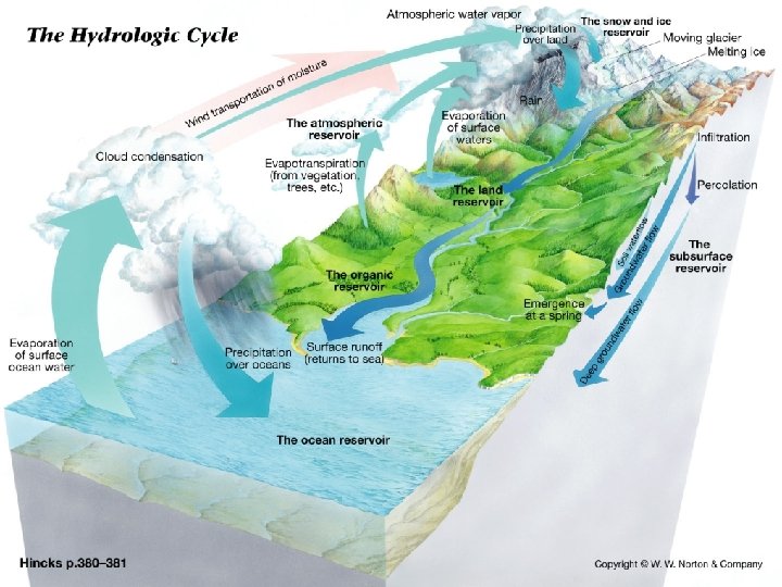
Sculpting the Earth’s Surface Water
Hydrologic Cycle
The Hydrologic Cycle § The Three Fates of Precipitation – – – Infiltration Runoff Evapotranspiration
The Hydrologic Cycle § Infiltration capacity of the soil is controlled by: – – – Intensity and duration of rainfall Soil saturation Soil texture Slope of the land Nature of the vegetative cover
Surface Water § Saline Water – – Oceans Bays Estuaries Some lakes § Fresh water – Lakes – Rivers § Ground Water – In the Earth, flows through fractures and pores
Rivers § Function: – Move runoff away from land out to the sea (or lake) – Transport sediments (erosion)
Rivers § Factors that determine velocity – Gradient, or slope – Channel characteristics § § § Shape Size Roughness – Discharge – volume of water flowing in the stream (generally expresses as cubic feet per second)
Rivers § Erosion = transportation of sediments – – – Dissolved load Suspended load Bed load § Streambed sediments = Alluvium
How Streams Move Sediment
Rivers § Load is related to a stream's – – – Competence - maximum particle size Capacity - maximum load Capacity is related to discharge
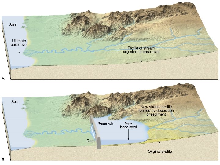
Rivers – Profile
Rivers § Stream order: – First-order streams have no tributaries but join to form a second-order stream and so on
Rivers Drainage basins and patterns A divide separates drainage basin Types of drainage patterns
The drainage basin of the Mississippi River
A River’s Journey § Begins as sheetflow – Sheetflow develops into tiny channels called rills – Eventually flows into streams, rivers & lakes
A River’s Journey § Headlands – Vertical erosion – Valleys are narrow & V-Shaped Arroyo Seco in the San Gabriel Mountains, Angeles Crest Highway looking towards La Canada & Los Angeles Photo by S. Leyva © 2006
A River’s Journey § Headlands – – – Smaller channel = Smaller discharge = Higher velocity = higher energy = greater competence Larger particles can be moved (clays through small boulders) § Smaller grain sizes moved downstream § Riverbeds typically contain large boulders Sturveyant Falls Trail, San Gabriel Mountains Photo by S. Leyva © 2001
A River’s Journey § Headlands – Features: § Rapids § Waterfalls § Benches
Forming Stream Terraces
A River’s Journey § Transition from mountains to flatlands – Stream velocity decreases – Decreased velocity = decreased competence = deposition of load – Features § Alluvial Fans § Braided Streams Source: Hyndman & Hyndman’s Natural Hazards & Disasters (http: //earthscience. brookscole. com/hyndman)
A River’s Journey § Transition from mountains to flatlands – Braided streams typically develop in areas where: § Sediment is abundant § Water discharge is high and sporadic (i. e. seasonal) § Vegetation is sparse – Braiding occurs due to: § Large, rapid fluctuations in river discharge § Large amounts of coarse sediment § Riverbanks that are easily erodible
Braided Rivers Brahmaputra River, Bangladesh From: Geomorphology from Space. http: //daac. gsfc. nasa. gov/DAAC_DOCS/geomorphology/GEO_4/GEO_PLATE_F-13. HTML
Braided Rivers Yukon River, Alaska The Yukon channel shows a typical braided pattern as it flows over lowlands of Quaternary alluvium known as the Yukon Flats. In this late summer scene, the river is at high flow, transporting snowmelt from nearby mountain ranges. Approximately 700 km to the west, at its junction with the Koyukuk River, the Yukon no longer has a braided pattern. Instead, meander scrolls and anastomosing side channels dominate the lower Yukon. From: Geomorphology from Space. http: //daac. gsfc. nasa. gov/DAAC_DOCS/geomorphology/GEO_4/ GEO_PLATE_F-12. HTML
River Sinuosity
A River’s Journey § Flatlands – Lateral erosion – Valleys are wide & flat Source: Hyndman & Hyndman’s Natural Hazards & Disasters (http: //earthscience. brookscole. com/hyndman)
A River’s Journey § Flatlands – – – Larger channel = Larger discharge = Lower velocity = lower energy = decreased competence Only small grain sizes can be moved (clays and silts) § Smaller grain sizes moved downstream § Riverbeds typically contain sands and gravels – Various river types can develop
River Types From: Miall (1977)
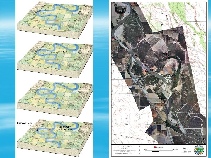
A River’s Journey § Flatlands – Features: § § § Floodplains Yazoo tributaries Backswamps Meanders Oxbow lakes
Floodplain, backswamp & Yazoo Tributary
Natural Levees
Meanders
Oxbow Lakes
A River’s Journey § Rivers empty out into lakes or oceans – Decreased velocity = decreased competence = deposition of load § Deltas § Ocean canyons
Deltas in various parts of the world
The Mississippi River Delta
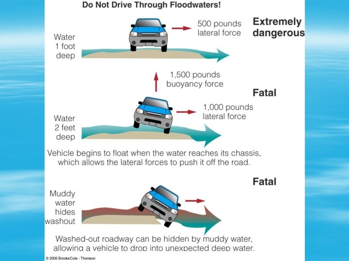
Floods § The Worst Geological Hazard – They are the most costly in terms of life, property, and land – They can occur almost anywhere
Floods § The Worst Geological Hazard – Damage is caused by: § § Erosion by flood waters Impact of water on structures Sediment deposition Contamination of surface waters
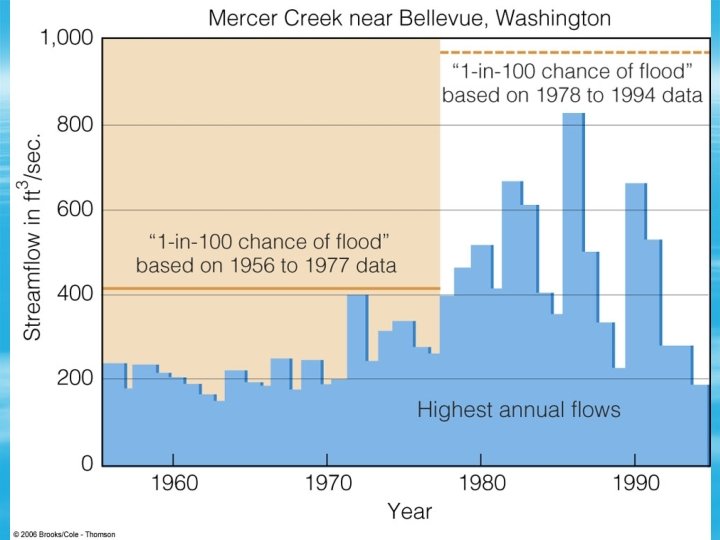
Floods § Recurrence Interval – Time between floods of the same magnitude – Example: there is 1 in 100 chance that a peak flow of a certain amount (say, 30, 000 cf/s) can occur on a river. – Thus, that river is said to have a 100 -year interval
Floods § Recurrence Interval – Engineers design for particular recurrence intervals § § § Streets 2 -5 years Debris dams 5 – 25 years Upper valley dams 100 years Levees 100 yrs Large dams 1000+ years
Floods § Types of floods – – – Flash Flooding In Arroyos/washes River (Regional) Flood Coastal Flood Urban Flood Ice Jam Dam Failure
Types of Floods § Flash Flooding In Arroyos/washes – Typically caused by: § Intense rainfall § Short period of time § Topography, soil conditions, and ground cover also important
Types of Floods § Flash Flooding In Arroyos/washes – Damage: § § § Roll boulders Tear out trees Destroy buildings and bridges Scour out new channels Landslides Sturveyant Falls Trail, San Gabriel Mountains Photo by S. Leyva © 2001
Types of Floods § River (Regional) Flood – Some floods occur seasonally when winter or spring rains, coupled with melting snows, fill river basins with too much water, too quickly. – Torrential rains from decaying hurricanes or tropical systems can also produce river flooding.
River (Regional) Floods § Upstream floods – generally local in extent & short lag times. – result from intense storms of short duration. § Downstream floods – regional in extent & longer lag times – higher peak discharges. – Result from regional storms of long duration or extended periods of above-normal precipitation.
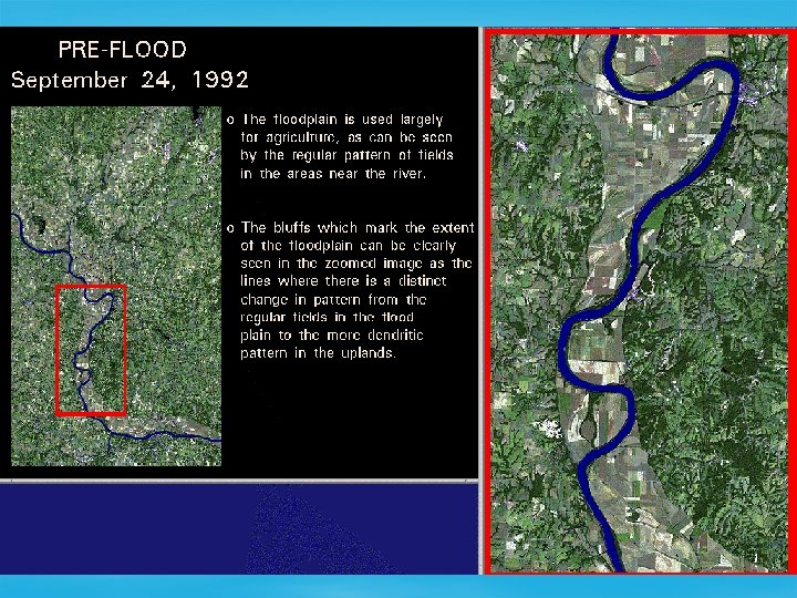
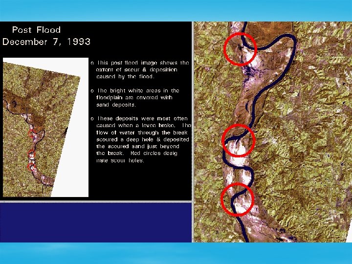
Missouri and Mississippi rivers near St. Louis before (1988) and after peak flood conditions
Types of Floods § Coastal Flood – Often caused by storm surges. – Can also be produced by sea waves called tsunamis
Types of Floods § Urban Flood – Roads and parking lots prevent infiltration of water – Urbanization increases runoff 2 to 6 times over what would occur on natural terrain. – Streets can become swift moving rivers, can flood homes and businesses
Types of Floods § Ice Jam – Floating ice can accumulate at a natural or man-made obstruction and stop the flow of water.
Types of Floods § Dam Failure – St. Francis Dam 3/12/28 § Dream of William Mulholland § 200 ft high curved concrete gravity dam § Failed catastrophically at midnight upon first filling Source: http: //seis. natsci. csulb. edu/VIRTUAL_FIELD/Francesquito_ Dam/franmayn. htm
This colorized photo shows the St. Francis Dam on its day of formal dedication in May of 1926, almost two years before the failure. http: //web. umr. edu/~rogersda/st_francis_dam/
Photo, looking north, shows what was left of the St. Francis Dam shortly after it failed on March 12, 1928.
Determination of Past Events
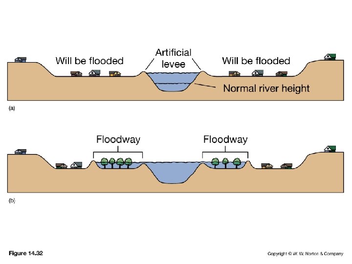
Societal Responses to Floods § Hard Responses – – – Dams Levees Sandbagging § Soft Responses – Watershed Management § Zoning and Land Use § Insurance § Erosion Control – Forecasting
Dams Created by S. Leyva © 2006
Levees
Levees
~ End ~