PREDECESSOR RAIN EVENTS IN ADVANCE OF TROPICAL CYCLONES










- Slides: 63

PREDECESSOR RAIN EVENTS IN ADVANCE OF TROPICAL CYCLONES Matthew R. Cote, Lance F. Bosart, Daniel Keyser Department of Earth and Atmospheric Sciences University at Albany, SUNY, Albany, NY Michael L. Jurewicz, Sr. National Weather Service Forecast Office Binghamton, NY CSTAR II Grant NA 04 NWS 4680005 Master’s Thesis Seminar 5 July 2007

MOTIVATION “…Map discussion focused on two heavy rain and flooding events in the Northeast that occurred well in advance of tropical systems (Katrina and Ophelia) in the past month. These types of warm-season heavy rain events have been observed a number of times over the Northeast in advance of landfalling and transitioning tropical cyclones. They are often difficult to forecast and they constitute a significant operational research problem. ” —Lance Bosart, in his synopsis of Friday Map Discussion, 16 Sep 2005

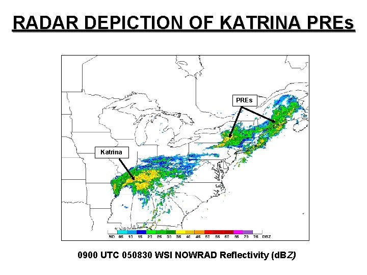
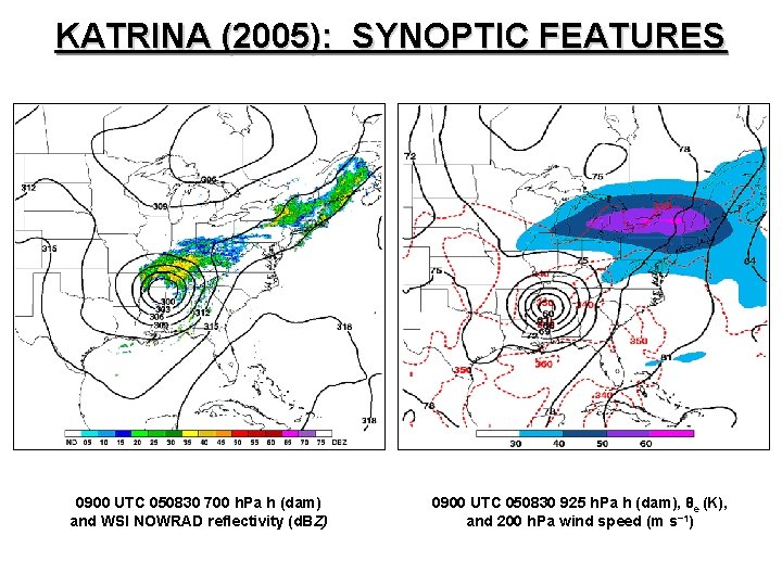
RADAR DEPICTION OF KATRINA PREs Katrina 0900 UTC 050830 WSI NOWRAD Reflectivity (d. BZ)

OUTLINE • Explain PRE identification process • Discuss related past research • Present statistical and composite climatology of PREs for 1998– 2006 • Examine the synoptic-scale and mesoscale factors important in producing two PREs ahead of Gaston (2004) • Suggest methods for efficient technology transfer into NWS operations

DATA SOURCES • NCDC and WSI NOWRAD radar imagery • NHC best-track data • NPVU QPE and NWS rainfall products • NCEP/NCAR 2. 5° × 2. 5° Reanalysis • NCEP/NARR 32 -km gridded datasets

IDENTIFYING PREs: 1998– 2006 • Coherent area of rain displaced poleward of TC • Maximum rainfall rates exceeded 100 mm in 24 h • Moisture transport from TC toward PRE

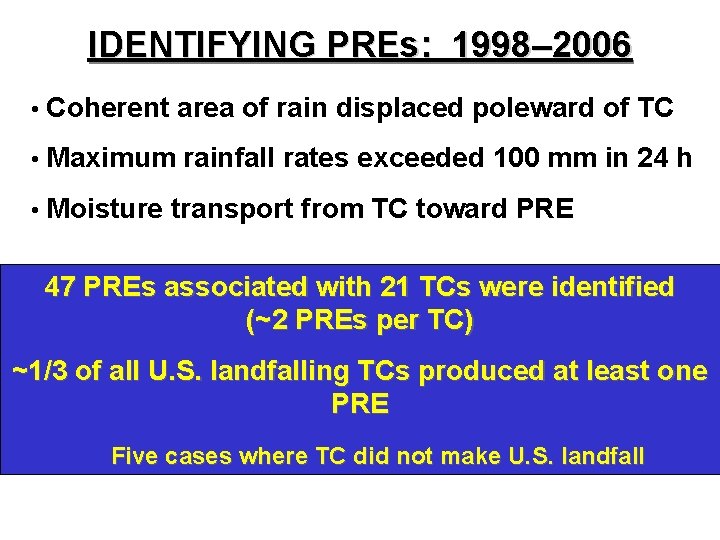
IDENTIFYING PREs: 1998– 2006 • Coherent area of rain displaced poleward of TC • Maximum rainfall rates exceeded 100 mm in 24 h • Moisture transport from TC toward PRE 47 PREs associated with 21 TCs were identified (~2 PREs per TC) ~1/3 of all U. S. landfalling TCs produced at least one PRE Five cases where TC did not make U. S. landfall

SEPARATION BY TC TRACK SIMILARITY

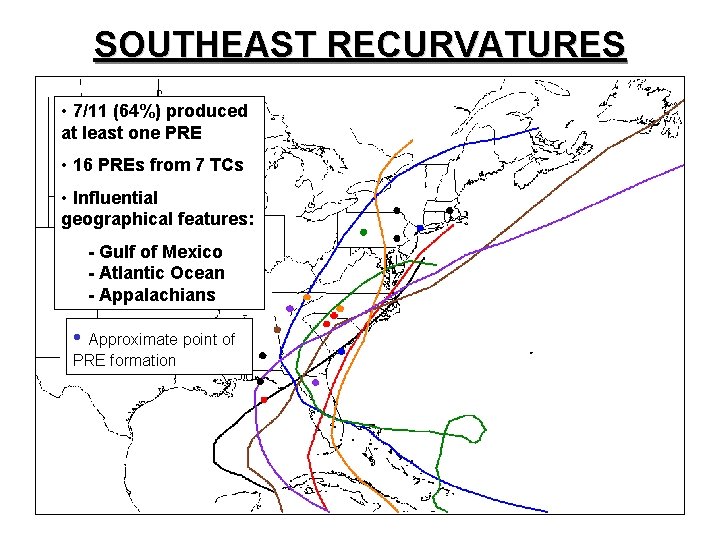
SOUTHEAST RECURVATURES • 7/11 (64%) produced at least one PRE • 16 PREs from 7 TCs • Influential geographical features: - Gulf of Mexico - Atlantic Ocean - Appalachians • Approximate point of PRE formation

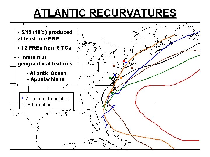
ATLANTIC RECURVATURES • 6/15 (40%) produced at least one PRE • 12 PREs from 6 TCs • Influential geographical features: - Atlantic Ocean - Appalachians • Approximate point of PRE formation

PREVIOUS RESEARCH

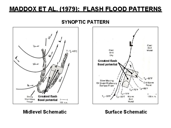
MADDOX ET AL. (1979): FLASH FLOOD PATTERNS SYNOPTIC PATTERN Greatest flash flood potential Midlevel Schematic Surface Schematic

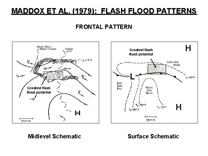
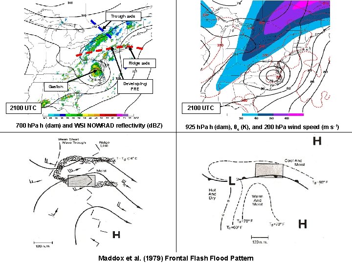
MADDOX ET AL. (1979): FLASH FLOOD PATTERNS FRONTAL PATTERN Greatest flash flood potential Midlevel Schematic Surface Schematic

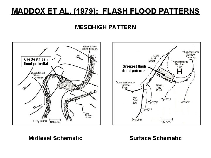
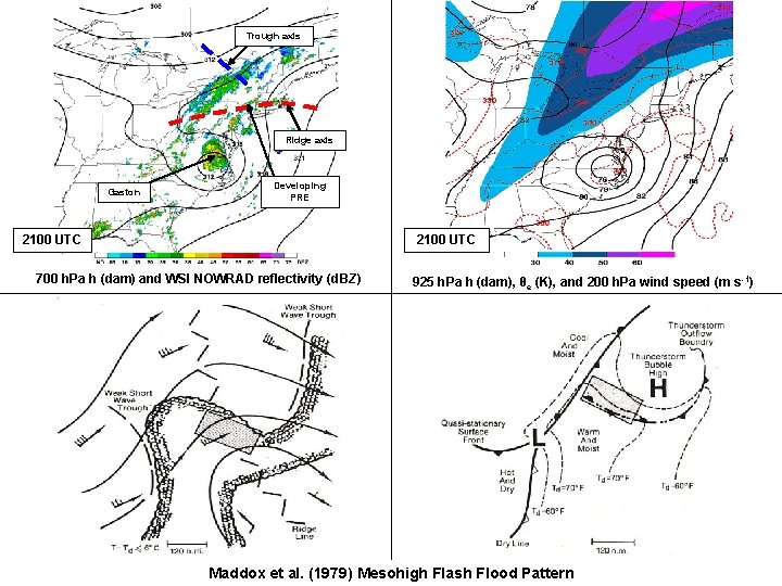
MADDOX ET AL. (1979): FLASH FLOOD PATTERNS MESOHIGH PATTERN Greatest flash flood potential Midlevel Schematic Greatest flash flood potential Surface Schematic

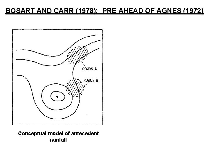
BOSART AND CARR (1978): PRE AHEAD OF AGNES (1972) Conceptual model of antecedent rainfall

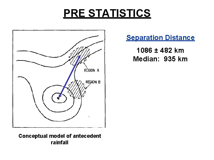
PRE STATISTICS Separation Distance 1086 ± 482 km Median: 935 km Conceptual model of antecedent rainfall

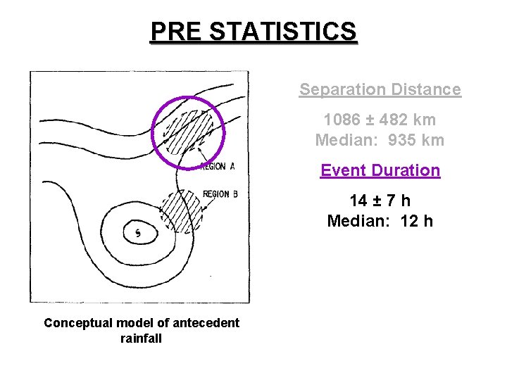
PRE STATISTICS Separation Distance 1086 ± 482 km Median: 935 km Event Duration 14 ± 7 h Median: 12 h Conceptual model of antecedent rainfall

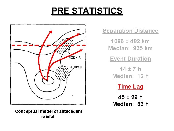
PRE STATISTICS Separation Distance 1086 ± 482 km Median: 935 km Event Duration 14 ± 7 h Median: 12 h Time Lag 45 ± 29 h Median: 36 h Conceptual model of antecedent rainfall

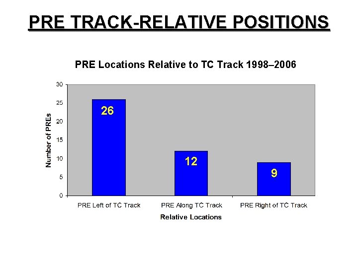
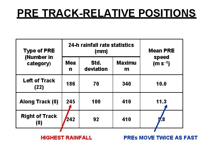
PRE TRACK-RELATIVE POSITIONS PRE Locations Relative to TC Track 1998– 2006 26 12 9

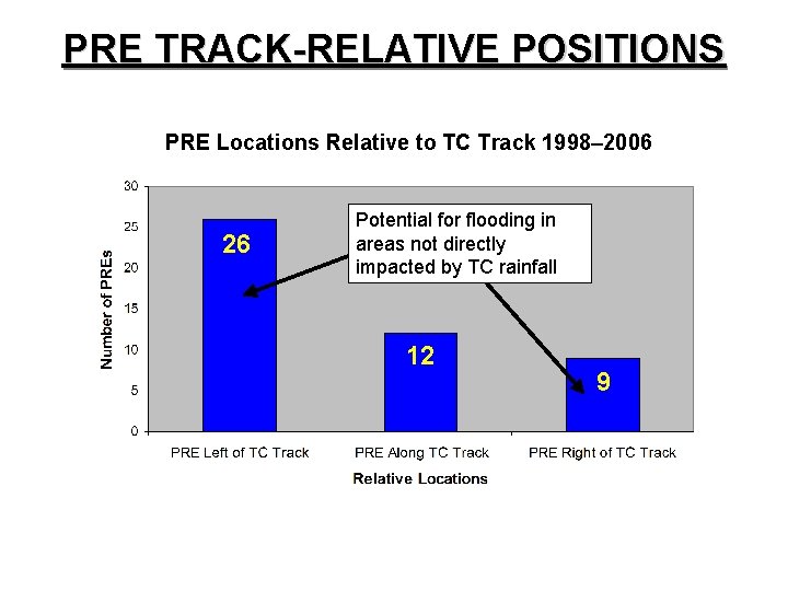
PRE TRACK-RELATIVE POSITIONS PRE Locations Relative to TC Track 1998– 2006 26 Potential for flooding in areas not directly impacted by TC rainfall 12 9

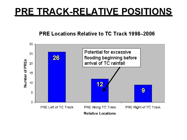
PRE TRACK-RELATIVE POSITIONS PRE Locations Relative to TC Track 1998– 2006 26 Potential for excessive flooding beginning before arrival of TC rainfall 12 9

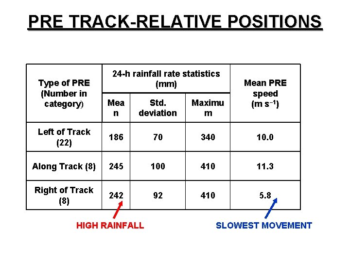
PRE TRACK-RELATIVE POSITIONS Type of PRE (Number in category) 24 -h rainfall rate statistics (mm) Mean PRE speed (m s− 1) Mea n Std. deviation Maximu m Left of Track (22) 186 70 340 10. 0 Along Track (8) 245 100 410 11. 3 Right of Track (8) 242 92 410 5. 8 HIGH RAINFALL SLOWEST MOVEMENT

PRE TRACK-RELATIVE POSITIONS Type of PRE (Number in category) 24 -h rainfall rate statistics (mm) Mean PRE speed (m s− 1) Mea n Std. deviation Maximu m Left of Track (22) 186 70 340 10. 0 Along Track (8) 245 100 410 11. 3 Right of Track (8) 242 92 410 5. 8 HIGHEST RAINFALL PREs MOVE TWICE AS FAST

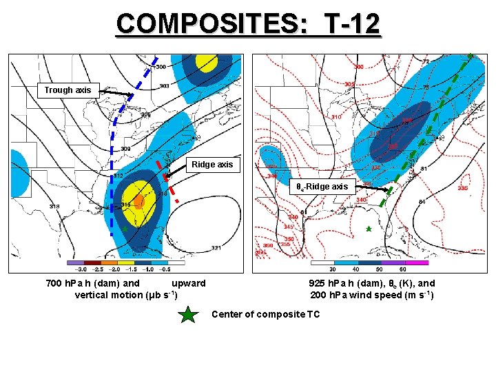
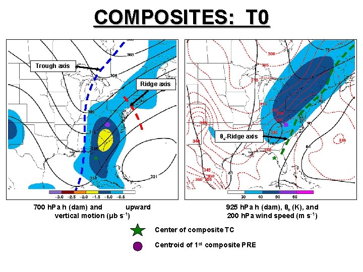
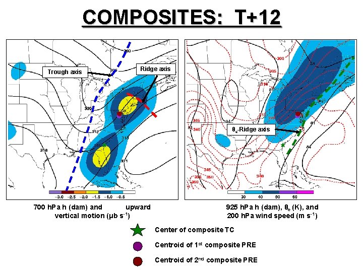
SOUTHEAST RECURVATURE PRE COMPOSITES

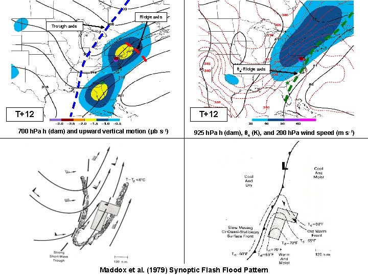
COMPOSITES: T-12 Trough axis Ridge axis θe-Ridge axis 700 h. Pa h (dam) and upward vertical motion (μb s-1) 925 h. Pa h (dam), θe (K), and 200 h. Pa wind speed (m s-1) Center of composite TC

COMPOSITES: T 0 Trough axis Ridge axis θe-Ridge axis 700 h. Pa h (dam) and upward vertical motion (μb s-1) 925 h. Pa h (dam), θe (K), and 200 h. Pa wind speed (m s-1) Center of composite TC Centroid of 1 st composite PRE

COMPOSITES: T+12 Trough axis Ridge axis θe-Ridge axis 700 h. Pa h (dam) and upward vertical motion (μb s-1) 925 h. Pa h (dam), θe (K), and 200 h. Pa wind speed (m s-1) Center of composite TC Centroid of 1 st composite PRE Centroid of 2 nd composite PRE

Ridge axis Trough axis θe-Ridge axis T+12 700 h. Pa h (dam) and upward vertical motion (μb s-1) 925 h. Pa h (dam), θe (K), and 200 h. Pa wind speed (m s -1) Maddox et al. (1979) Synoptic Flash Flood Pattern

GASTON (2004)

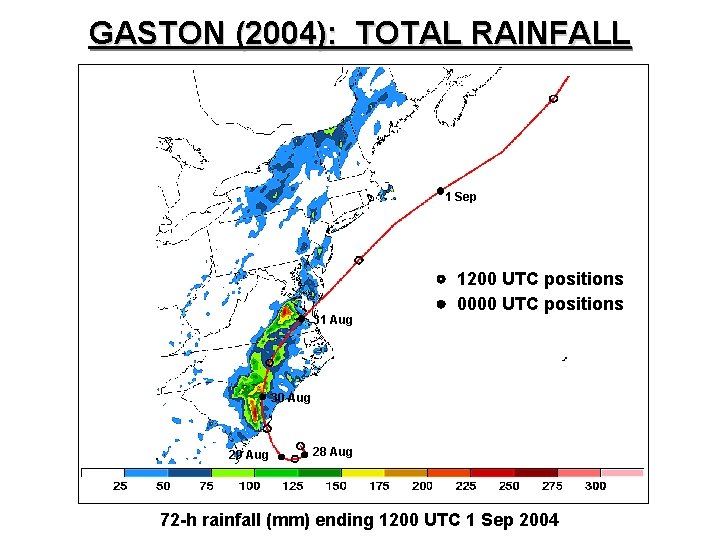
GASTON (2004): TOTAL RAINFALL 1 Sep 31 Aug 1200 UTC positions 0000 UTC positions 30 Aug 29 Aug 28 Aug 72 -h rainfall (mm) ending 1200 UTC 1 Sep 2004

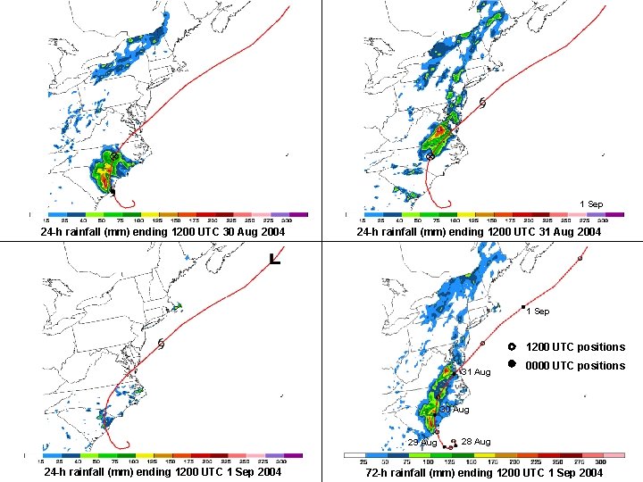
1 Sep 24 -h rainfall (mm) ending 1200 UTC 30 Aug 2004 24 -h rainfall (mm) ending 1200 UTC 31 Aug 2004 1 Sep 1200 UTC positions 31 Aug 0000 UTC positions 30 Aug 29 Aug 24 -h rainfall (mm) ending 1200 UTC 1 Sep 2004 28 Aug 72 -h rainfall (mm) ending 1200 UTC 1 Sep 2004

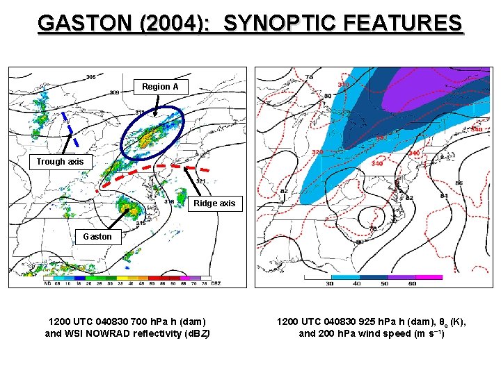
GASTON (2004): SYNOPTIC FEATURES Region A Trough axis Ridge axis Gaston 1200 UTC 040830 700 h. Pa h (dam) and WSI NOWRAD reflectivity (d. BZ) 1200 UTC 040830 925 h. Pa h (dam), θe (K), and 200 h. Pa wind speed (m s− 1)

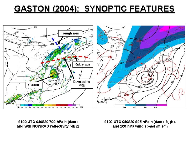
GASTON (2004): SYNOPTIC FEATURES Trough axis Ridge axis Gaston Developing PRE 2100 UTC 040830 700 h. Pa h (dam) and WSI NOWRAD reflectivity (d. BZ) 2100 UTC 040830 925 h. Pa h (dam), θe (K), and 200 h. Pa wind speed (m s− 1)

Trough axis Ridge axis Gaston Developing PRE 2100 UTC 700 h. Pa h (dam) and WSI NOWRAD reflectivity (d. BZ) 925 h. Pa h (dam), θe (K), and 200 h. Pa wind speed (m s -1) Maddox et al. (1979) Frontal Flash Flood Pattern

Trough axis Ridge axis Gaston Developing PRE 2100 UTC 700 h. Pa h (dam) and WSI NOWRAD reflectivity (d. BZ) 925 h. Pa h (dam), θe (K), and 200 h. Pa wind speed (m s -1) Maddox et al. (1979) Mesohigh Flash Flood Pattern

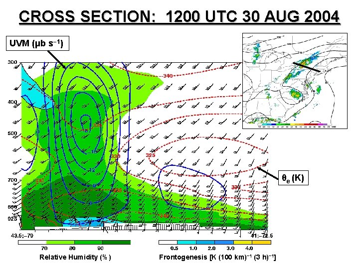
CROSS SECTION: 1200 UTC 30 AUG 2004 UVM (μb s− 1) θe (K) Relative Humidity (%) Frontogenesis [K (100 km)− 1 (3 h)− 1]

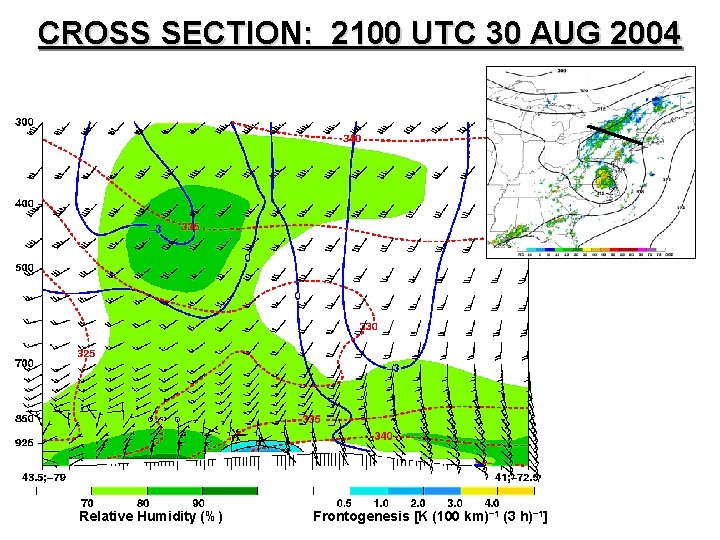
CROSS SECTION: 2100 UTC 30 AUG 2004 Relative Humidity (%) Frontogenesis [K (100 km)− 1 (3 h)− 1]

CLIMATOLOGY SUMMARY • ~1/3 of U. S. landfalling TCs produce at least one PRE, but landfall is not necessary • PREs form ~1000 km away from their parent TCs and ~1– 2 days in advance • LOT PREs are most common, but AT PREs produce the risk of most extreme flooding • Composites of SE Recurvature PREs resemble Maddox et al. (1979) synoptic flash flood pattern

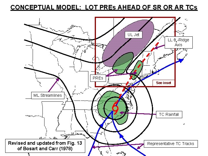
CONCEPTUAL MODEL: LOT PREs AHEAD OF SR OR AR TCs UL Jet LL θe-Ridge Axis PREs See inset ML Streamlines TC Rainfall Revised and updated from Fig. 13 of Bosart and Carr (1978) Representative TC Tracks

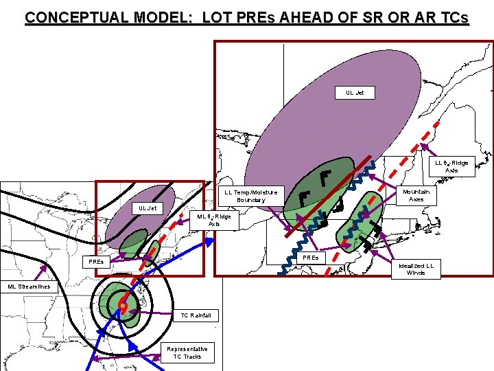
CONCEPTUAL MODEL: LOT PREs AHEAD OF SR OR AR TCs UL Jet LL θe-Ridge Axis Mountain Axes LL Temp/Moisture Boundary UL Jet ML θe-Ridge Axis PREs Idealized LL Winds ML Streamlines TC Rainfall Representative TC Tracks

TRANSFER OF PRE RESEARCH INTO OPERATIONS

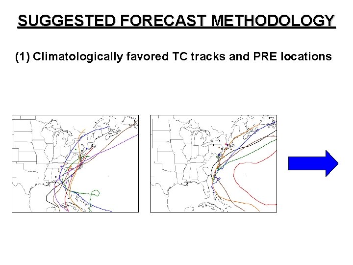
SUGGESTED FORECAST METHODOLOGY (1) Climatologically favored TC tracks and PRE locations

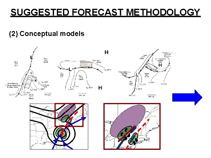
SUGGESTED FORECAST METHODOLOGY (2) Conceptual models

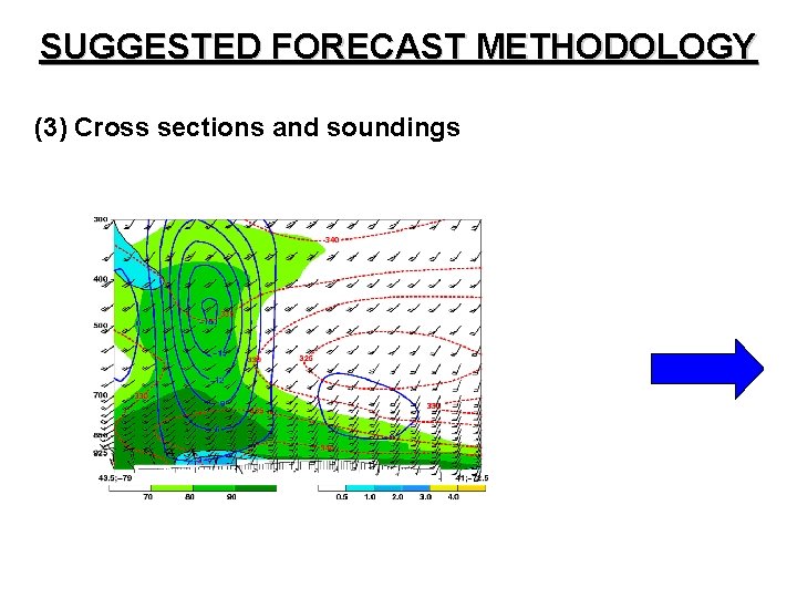
SUGGESTED FORECAST METHODOLOGY (3) Cross sections and soundings

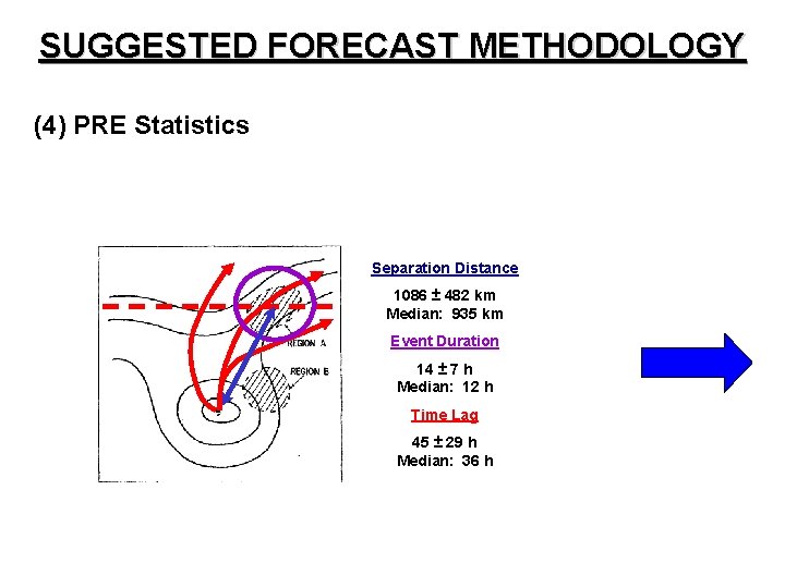
SUGGESTED FORECAST METHODOLOGY (4) PRE Statistics Separation Distance 1086 ± 482 km Median: 935 km Event Duration 14 ± 7 h Median: 12 h Time Lag 45 ± 29 h Median: 36 h

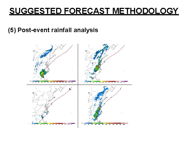
SUGGESTED FORECAST METHODOLOGY (5) Post-event rainfall analysis

SUGGESTIONS FOR FUTURE WORK • Apply “PV-thinking” to PRE cases • Perform modeling studies to assess PRE predictability and relative roles of different features • Construct composite soundings and calculate mean thermodynamic quantities • Develop methods for anticipating the mode of predecessor rain activity (i. e. , organized or scattered, intense or weak, slow- or fast-moving)

ACKNOWLEDGMENTS

ACKNOWLEDGMENTS • Lance and Dan • Mike Jurewicz • Kevin and Dave • Celeste, Lynn, Sharon, and Patti • Anyone I may have forgotten!

QUESTIONS? COMMENTS? mcote@atmos. albany. edu

KATRINA (2005)

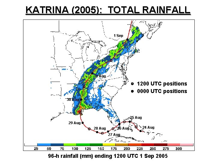
KATRINA (2005): TOTAL RAINFALL 1 Sep 31 Aug 1200 UTC positions 0000 UTC positions 30 Aug 25 Aug 29 Aug 28 Aug 26 Aug 24 Aug 27 Aug 96 -h rainfall (mm) ending 1200 UTC 1 Sep 2005

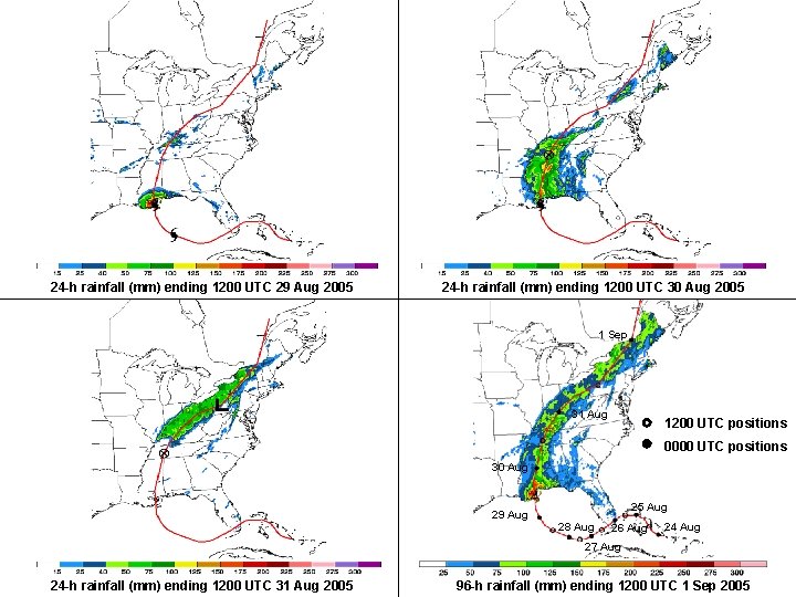
24 -h rainfall (mm) ending 1200 UTC 29 Aug 2005 24 -h rainfall (mm) ending 1200 UTC 30 Aug 2005 1 Sep 31 Aug 1200 UTC positions 0000 UTC positions 30 Aug 29 Aug 25 Aug 28 Aug 26 Aug 24 Aug 27 Aug 24 -h rainfall (mm) ending 1200 UTC 31 Aug 2005 96 -h rainfall (mm) ending 1200 UTC 1 Sep 2005

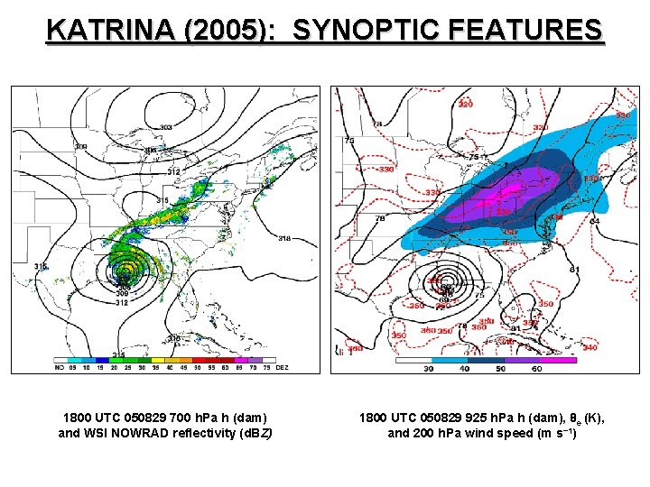
KATRINA (2005): SYNOPTIC FEATURES 1800 UTC 050829 700 h. Pa h (dam) and WSI NOWRAD reflectivity (d. BZ) 1800 UTC 050829 925 h. Pa h (dam), θe (K), and 200 h. Pa wind speed (m s− 1)

KATRINA (2005): SYNOPTIC FEATURES 0900 UTC 050830 700 h. Pa h (dam) and WSI NOWRAD reflectivity (d. BZ) 0900 UTC 050830 925 h. Pa h (dam), θe (K), and 200 h. Pa wind speed (m s− 1)

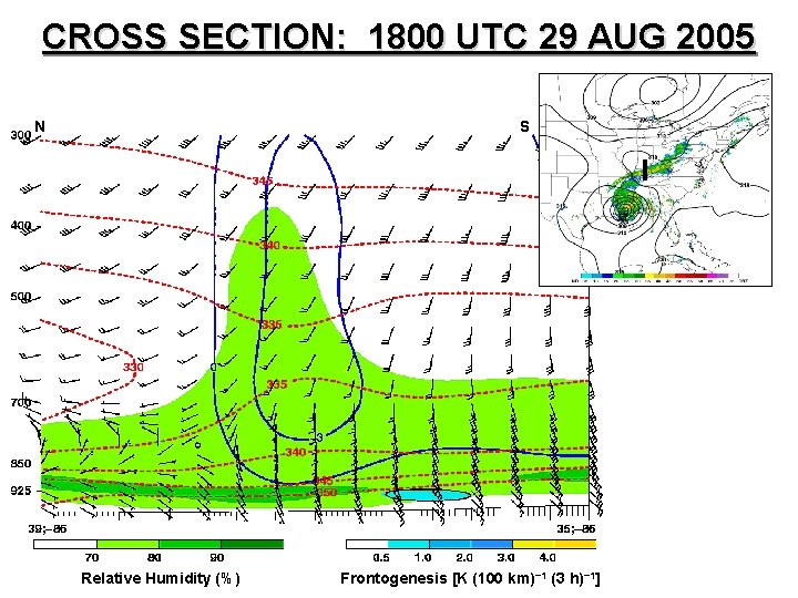
CROSS SECTION: 1800 UTC 29 AUG 2005 N S Relative Humidity (%) Frontogenesis [K (100 km)− 1 (3 h)− 1]

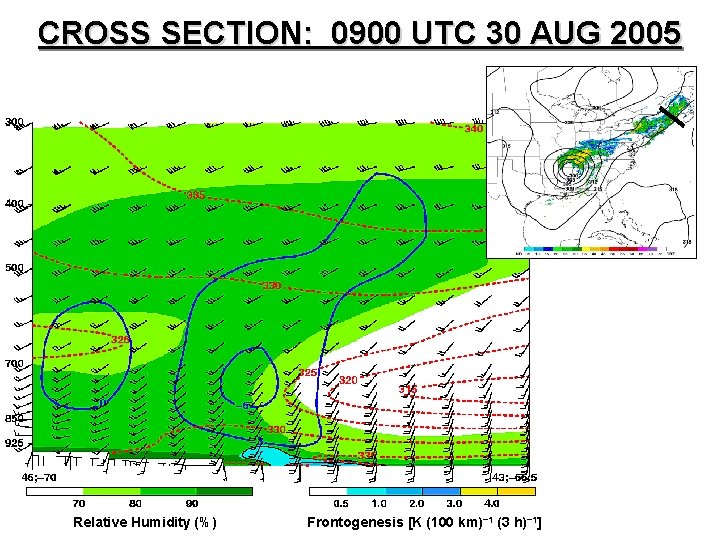
CROSS SECTION: 0900 UTC 30 AUG 2005 Relative Humidity (%) Frontogenesis [K (100 km)− 1 (3 h)− 1]

CINDY (2005)

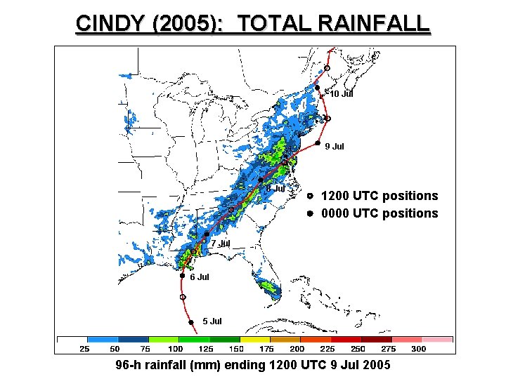
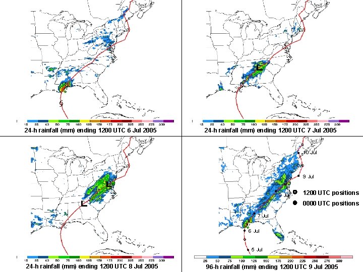
CINDY (2005): TOTAL RAINFALL 10 Jul 9 Jul 8 Jul 1200 UTC positions 0000 UTC positions 7 Jul 6 Jul 5 Jul 96 -h rainfall (mm) ending 1200 UTC 9 Jul 2005

24 -h rainfall (mm) ending 1200 UTC 6 Jul 2005 24 -h rainfall (mm) ending 1200 UTC 7 Jul 2005 10 Jul 9 Jul 8 Jul 1200 UTC positions 0000 UTC positions 7 Jul 6 Jul 5 Jul 24 -h rainfall (mm) ending 1200 UTC 8 Jul 2005 96 -h rainfall (mm) ending 1200 UTC 9 Jul 2005

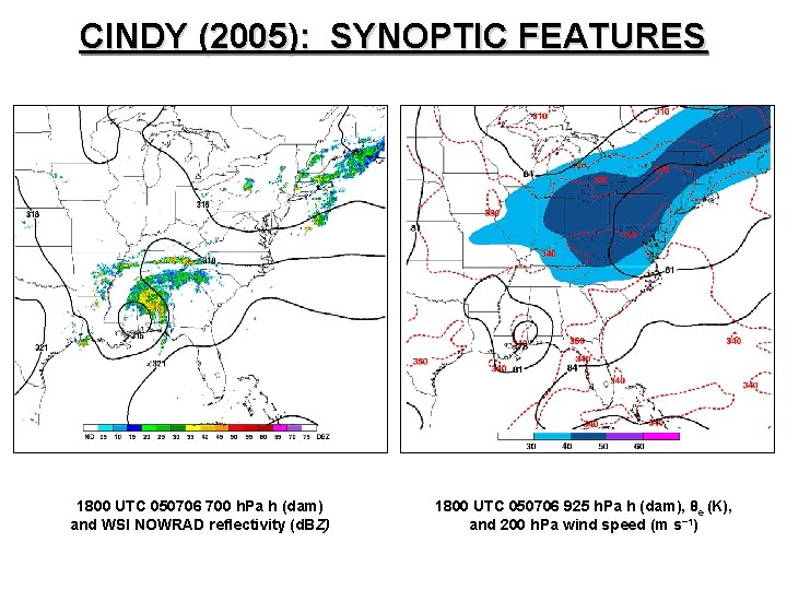
CINDY (2005): SYNOPTIC FEATURES 1800 UTC 050706 700 h. Pa h (dam) and WSI NOWRAD reflectivity (d. BZ) 1800 UTC 050706 925 h. Pa h (dam), θe (K), and 200 h. Pa wind speed (m s− 1)

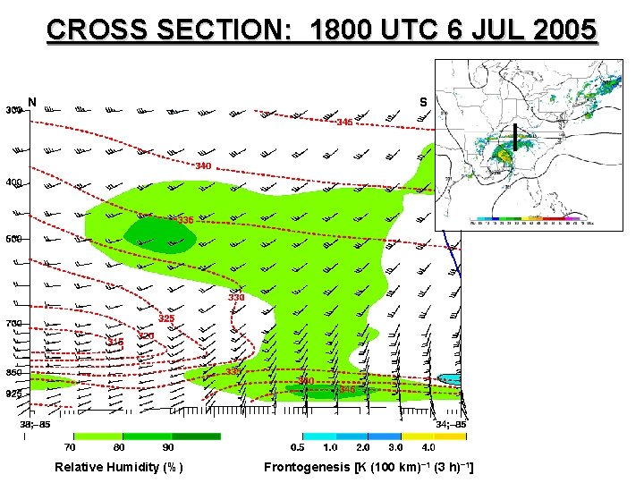
CROSS SECTION: 1800 UTC 6 JUL 2005 N S Relative Humidity (%) Frontogenesis [K (100 km)− 1 (3 h)− 1]
