
Predecessor Rainfall Events PRE in Tropical Cyclones Results


- Slides: 55
Predecessor Rainfall Events (PRE) in Tropical Cyclones - Results from a Recent Northeastern U. S. Collaborative Science, Technology, and Research (CSTAR) Project Matthew Cote, Lance Bosart, and Daniel Keyser State University of New York, Albany, NY Michael L. Jurewicz, Sr. National Weather Service, Binghamton, NY July 10, 2008 – HPC, Camp Springs, MD 1
Outline • Data Sources • Definition of PRE • Motivating factors / goals for this session • Methodologies for the project • Categorize PRE / Establish climatologies for the Eastern U. S. / Atlantic Basin TC • Provide operational forecasting resources – Composites / Conceptual models • Case Study Examples • Summary 2
Data Sources • WSI NOWRAD Radar Imagery • HPC Surface / Radar Analyses • SPC Upper-Air / Mesoanalyses • Archived TC Tracks / Positions from TPC • NARR 32 -km Datasets • NWS WES Imagery • NPVU QPE Data from NWS RFC’s 3
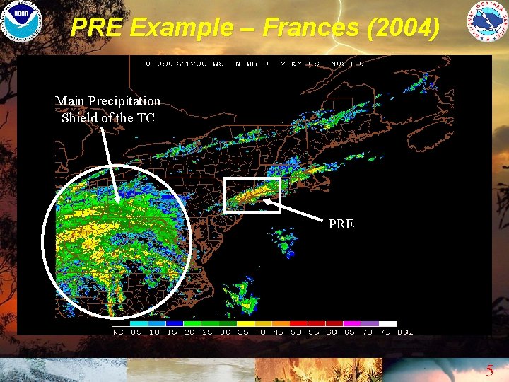
PRE – What are They ? • Coherent areas of heavy rainfall observed poleward of Tropical Cyclones (TC) – Distinct from the main precipitation shields of TC, or their extra-tropical remnants – Yet, still indirectly tied to TC 4
PRE Example – Frances (2004) Main Precipitation Shield of the TC PRE 5
Results of the Frances PRE 6
Motivation for Research • PRE can be particularly challenging phenomena for operational meteorologists – NWP models often underestimate / misplace heavy rainfall associated with PRE • Poor handling of diabatic heating transfer / upper-jet intensification – Attention is frequently diverted to different areas / times • Closer to where TC make landfall • Future time periods when the more direct impacts of TC or their remnants may be expected 7
Goals • To provide NWS forecasters / operational meteorologists with: – Background Knowledge / Awareness of PRE – Forecast Tools • PRE Climatologies • Conceptual Models / Composite Charts • Case Study Examples 8
Methodology • We restricted classifications of PRE to systems that met the following criteria: – 100 mm (4”) of rainfall needed to be observed within a 24 -hour period – Such rainfall had to be connected with a well defined region of precipitation • Not scattered / isolated convection 9
Frequency of Occurrence • Our period of study ran from 1998 to 2006 • 47 PRE were identified, which were tied to a total of 21 TC – An average of about 2 PRE per PRE-producing TC (PPTC) • About 1/3 of all Atlantic Basin TC that made U. S. Landfall for this period were PPTC – A few outlier PPTC did not actually make landfall 10
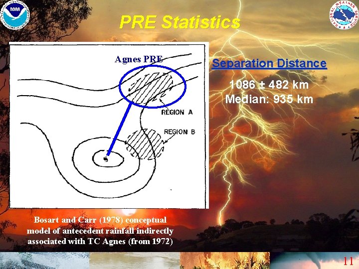
PRE Statistics Agnes PRE Separation Distance 1086 ± 482 km Median: 935 km Bosart and Carr (1978) conceptual model of antecedent rainfall indirectly associated with TC Agnes (from 1972) 11
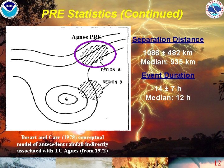
PRE Statistics (Continued) Agnes PRE Separation Distance 1086 ± 482 km Median: 935 km Event Duration 14 ± 7 h Median: 12 h Bosart and Carr (1978) conceptual model of antecedent rainfall indirectly associated with TC Agnes (from 1972) 12
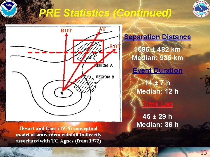
PRE Statistics (Continued) ROT AT Separation Distance LOT 1086 ± 482 km Median: 935 km Event Duration 14 ± 7 h Median: 12 h Time Lag Bosart and Carr (1978) conceptual model of antecedent rainfall indirectly associated with TC Agnes (from 1972) 45 ± 29 h Median: 36 h 13
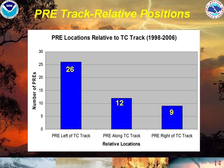
PRE Track-Relative Positions 26 12 9 14
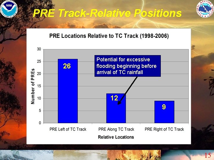
PRE Track-Relative Positions 26 Potential for excessive flooding beginning before arrival of TC rainfall 12 9 15
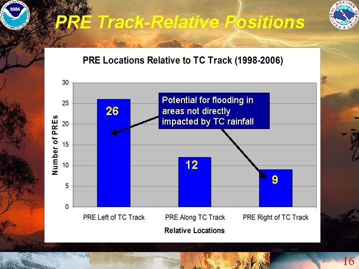
PRE Track-Relative Positions 26 Potential for flooding in areas not directly impacted by TC rainfall 12 9 16
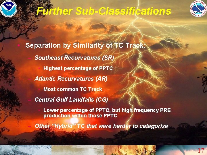
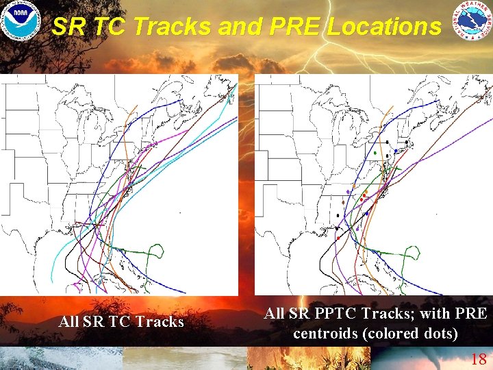
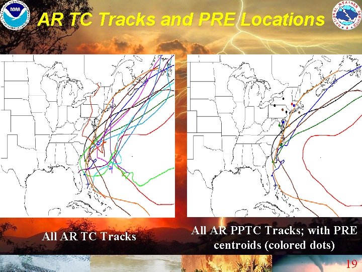
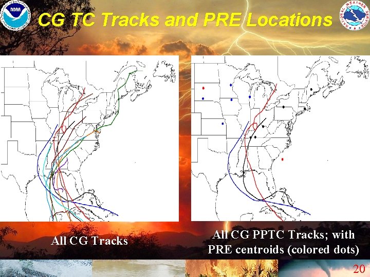
Further Sub-Classifications • Separation by Similarity of TC Track: – Southeast Recurvatures (SR) • Highest percentage of PPTC – Atlantic Recurvatures (AR) • Most common TC Track – Central Gulf Landfalls (CG) • Lower percentage of PPTC, but high frequency PRE production within those PPTC – Other “Hybrid” TC that were harder to categorize 17
SR TC Tracks and PRE Locations All SR TC Tracks All SR PPTC Tracks; with PRE centroids (colored dots) 18
AR TC Tracks and PRE Locations All AR TC Tracks All AR PPTC Tracks; with PRE centroids (colored dots) 19
CG TC Tracks and PRE Locations All CG Tracks All CG PPTC Tracks; with PRE centroids (colored dots) 20
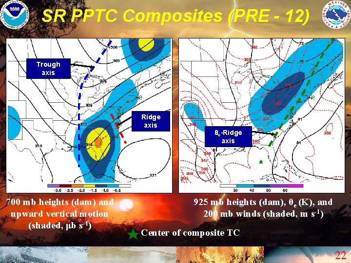
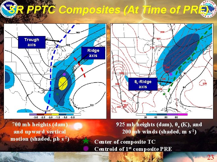
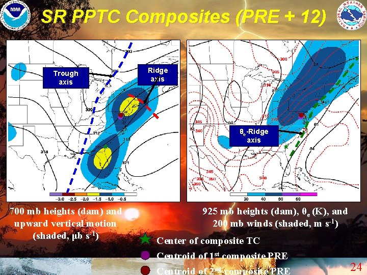
Favorable Locations for PRE • Within the Right-rear quadrant (RRQ) of an Upper-level Jet • Ahead of the Mean Long-Wave Trough Axis at Mid-levels (trough axis is west of the parent TC’s longitude) – Near or just upstream from Short-wave Ridging • Near a Low-level Front / Baroclinic Zone • On the periphery of a Tropical Moisture Plume • Near or just west of a Low-level Theta-E Ridge Axis 21
SR PPTC Composites (PRE - 12) Trough axis Ridge axis 700 mb heights (dam) and upward vertical motion (shaded, μb s-1) θe-Ridge axis 925 mb heights (dam), θe (K), and 200 mb winds (shaded, m s-1) Center of composite TC 22
SR PPTC Composites (At Time of PRE) Trough axis Ridge axis θe-Ridge axis 700 mb heights (dam) and upward vertical motion (shaded, μb s-1) 925 mb heights (dam), θe (K), and 200 mb winds (shaded, m s-1) Center of composite TC Centroid of 1 st composite PRE 23
SR PPTC Composites (PRE + 12) Trough axis Ridge axis θe-Ridge axis 700 mb heights (dam) and upward vertical motion (shaded, μb s-1) 925 mb heights (dam), θe (K), and 200 mb winds (shaded, m s-1) Center of composite TC Centroid of 1 st composite PRE Centroid of 2 nd composite PRE 24
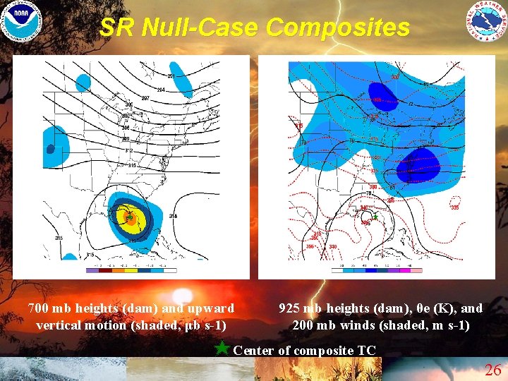
Common Detracting Elements for PRE Formation • A Zonal Flow Pattern is in place Poleward of the TC – Lack of merdional flow discourages northward return of deep tropical moisture away from the TC itself • The Long-wave Mid-level Trough Axis is already east of the TC’s Longitude • A Low-level Blocking Ridge is located north / northeast of the TC – Tends to prevent significant moisture inflow into any frontal boundaries or jet circulations that may be poleward of the TC 25
SR Null-Case Composites 700 mb heights (dam) and upward vertical motion (shaded, μb s-1) 925 mb heights (dam), θe (K), and 200 mb winds (shaded, m s-1) Center of composite TC 26
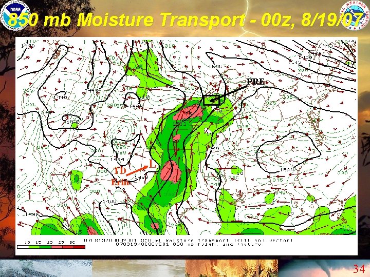
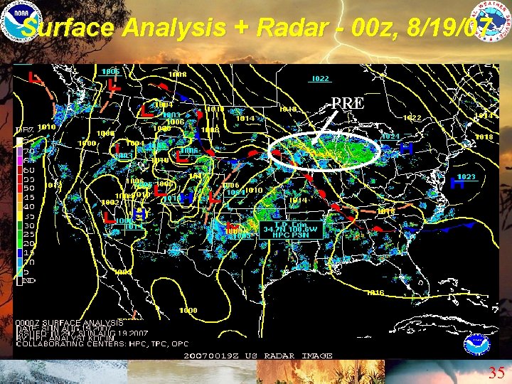
Case Study (TC Erin, 2007) • CG Landfall PPTC – Several PRE were associated with Erin (typical of CG PPTC) • Erin’s PRE exhibited many of the “classic” synoptic-scale ingredients – Within RRQ of an upper-level jet – Deep moisture was fed northward into the PRE / pronounced theta-e ridging developed – A low-level boundary was in the vicinity 27
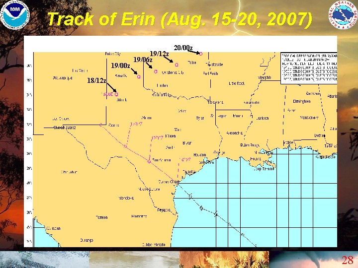
Track of Erin (Aug. 15 -20, 2007) 19/00 z 19/12 z 19/06 z 20/00 z 18/12 z 28
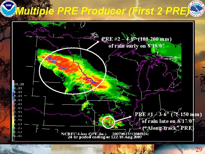
Multiple PRE Producer (First 2 PRE) PRE #2 – 4 -8” (100 -200 mm) of rain early on 8/18/07 PRE #1 – 3 -6” (75 -150 mm) of rain late on 8/17/07 (“Along-track” PRE) 29
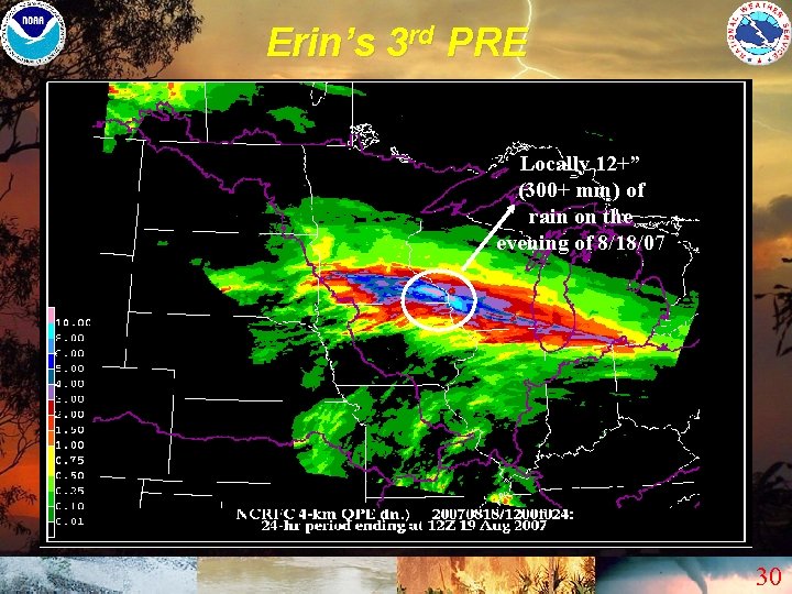
Erin’s 3 rd PRE Locally 10+12+” “ Locally (300+ mm) of rain on the evening of 8/18/07 30
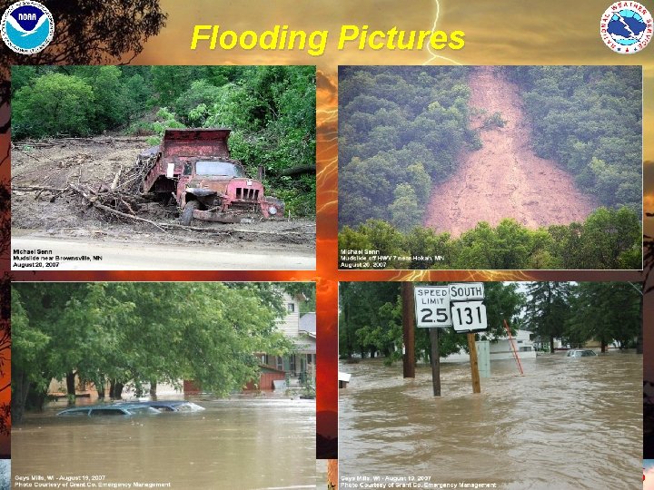
Ramifications of PRE #3 • 12” - 15” of rain fell in 6 hours or less over parts of Southeastern MN and Southwestern WI – Record flooding – Several fatalities 31
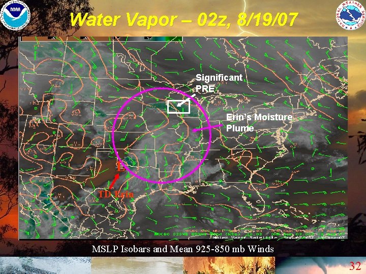
Water Vapor – 02 z, 8/19/07 Significant PRE Erin’s Moisture Plume L TD Erin MSLP Isobars and Mean 925 -850 mb Winds 32
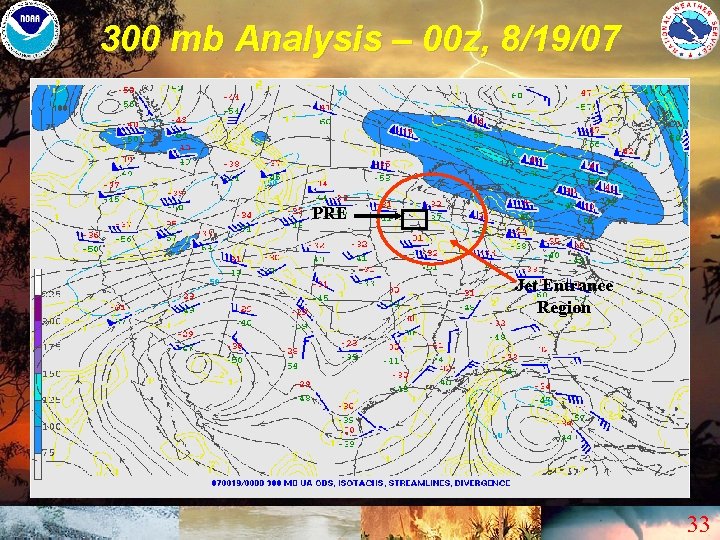
300 mb Analysis – 00 z, 8/19/07 PRE Jet Entrance Region 33
850 mb Moisture Transport - 00 z, 8/19/07 PRE TD Erin L 34
Surface Analysis + Radar - 00 z, 8/19/07 PRE 35
Flooding Pictures 36
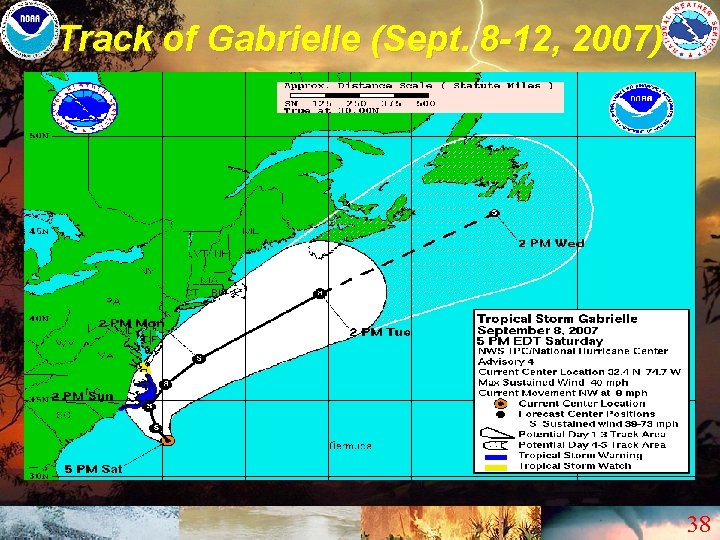
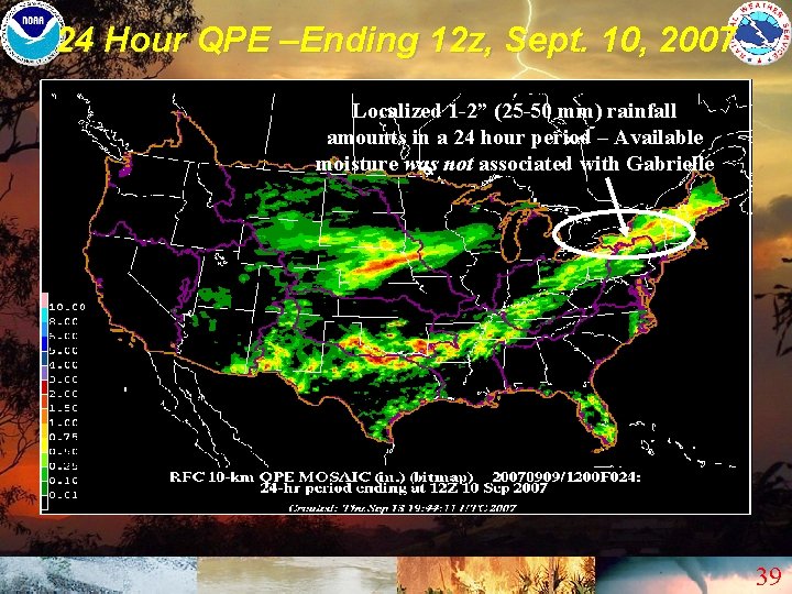
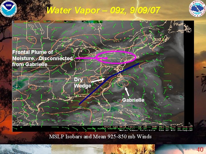
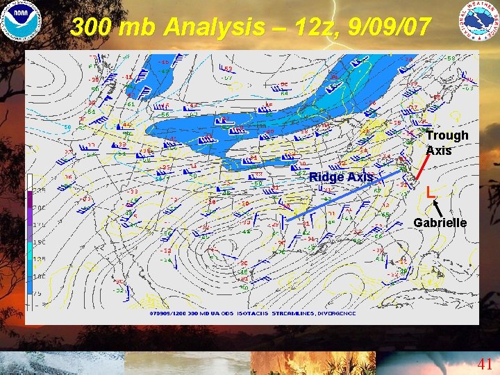
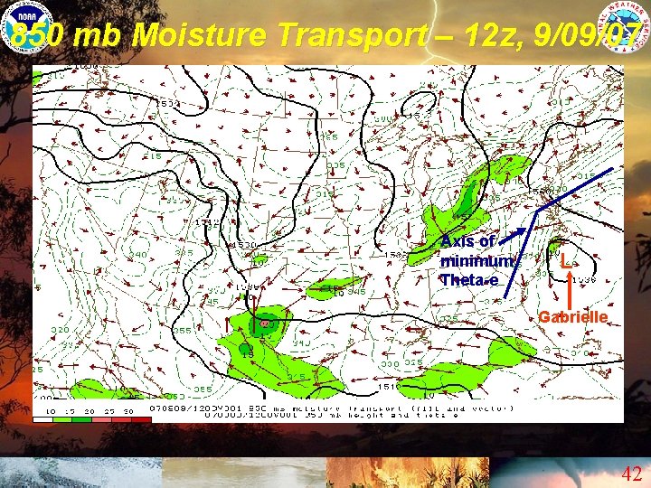
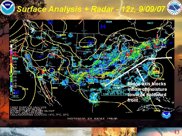
Null-Case Study (TC Gabrielle, 2007) • Became a Tropical Storm over the western Atlantic, before brushing the Outer Banks of NC – Then recurved towards the east-northeast over the open Atlantic (Would be categorized as an AR TC) • No PRE were associated with this TC – Expansive ridge axis blocked advection of deeper moisture into the U. S. 37
Track of Gabrielle (Sept. 8 -12, 2007) 38
24 Hour QPE –Ending 12 z, Sept. 10, 2007 Localized 1 -2” (25 -50 mm) rainfall amounts in a 24 hour period – Available moisture was not associated with Gabrielle 39
Water Vapor – 09 z, 9/09/07 Frontal Plume of Moisture…Disconnected from Gabrielle Dry Wedge Gabrielle MSLP Isobars and Mean 925 -850 mb Winds 40
300 mb Analysis – 12 z, 9/09/07 Trough Axis Ridge Axis L Gabrielle 41
850 mb Moisture Transport – 12 z, 9/09/07 Axis of minimum Theta-e L Gabrielle 42
Surface Analysis + Radar - 12 z, 9/09/07 Ridge axis blocks inflow of moisture towards poleward front 43
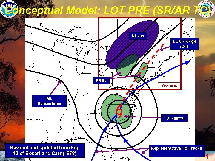
Conceptual Model: LOT PRE (SR/AR TC) UL Jet LL θe-Ridge Axis PREs See inset ML Streamlines TC Rainfall Revised and updated from Fig. 13 of Bosart and Carr (1978) Representative TC Tracks 44
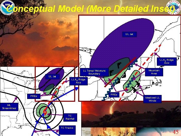
Conceptual Model (More Detailed Inset) UL Jet LL θe-Ridge Axis Mountain Axes LL Temp/ Moisture Boundary UL Jet LL θe-Ridge Axis PREs Idealized LL Winds ML Streamlines TC Rainfall TC Tracks 45
Summary – Forecast Challenges • NWP models are often poor with the placement / intensity of PRE • Attention is frequently diverted away from potential PRE development • PRE can impact almost any area of the CONUS 46
Summary – PRE Statistics • About 1/3 of U. S. Landfalling TC in our period of study (1998 -2006) were PPTC • LOT PRE were the most common – Typically the best synoptic enhancement • AT PRE can be the most dangerous – Double-shot of heavy rainfall • ROT PRE tended to display the highest rainfall rates – Typically slower moving PRE, with less synoptic forcing – Orography perhaps more important 47
Summary – Similarity of TC Tracks • SR TC had the highest percentage of PPTC • AR TC were the most common in our period of study – However, had a lower percentage of PPTC • CG TC had the lowest percentage of PPTC – However, CG PPTC were the most prolific PRE producers (an average of 3 -4 PRE per TC) 48
Summary – Favored PRE Locations • Within the RRQ of a strengthening poleward upper-level jet streak • Downstream of a mid-level trough, which is well west of the parent TC’s longitude • Near a low-level boundary • On the northern or western fringes of a deep tropical moisture plume (evident on water vapor imagery) • Near or just west of a low-level theta-e ridge axis 49
Summary – Unfavorable Setup for PRE • A de-amplified, zonally oriented flow pattern is in place north of the TC • The main poleward mid-level trough axis is already at, or east of the TC’s longitude • A low-level blocking ridge is north / northeast of the TC 50
Future Work • Expand PRE database to include the western U. S. (Pacific Basin TC) • Add composites / conceptual models for AT and ROT PRE, and possibly other TC tracks (i. e. CG) • Develop a technique to identify / quantify PRE rainfall in TC precipitation analyses • Perform modeling studies to interrogate the role that TC have in modulating the strength of poleward jets 51
References • Atallah, E. H. , and L. F. Bosart, 2003: The extratropical transition and precipitation distribution of Hurricane Floyd (1999). Mon. Wea. Rev. , 131, 1063– 1081. • Atallah, E. , L. F. Bosart, and A. R. Aiyyer, 2007: Precipitation distribution associated with landfalling tropical cyclones over the eastern United States. Mon. Wea. Rev. , 135, 2185– 2206. • Bosart and F. H. Carr, 1978: A case study of excessive rainfall centered around Wellsville, New York, 20 -21 June 1972. Mon. Wea. Rev. , 106, 348– 362. • Bosart and D. B. Dean, 1991: The Agnes rainstorm of June 1972: Surface feature evolution culminating in inland storm redevelopment. Wea. and Forecasting, 6, 515– 537. • Brooks, H. E. , and D. J. Stensrud, 2000: Climatology of heavy rain events in the United States from hourly precipitation observations. Mon. Wea. Rev. , 128, 1194– 1201. • De. Luca, D. P. , 2004: The distribution of precipitation over the Northeast accompanying landfalling and transitioning tropical cyclones. M. S. thesis, Department of Earth and Atmospheric Sciences, University at Albany, State University of New York, 177 pp. • Di. Mego, G. J. , and L. F. Bosart, 1982 a: The transformation of tropical storm Agnes into an extratropical cyclone. Part I: The observed fields and vertical motion computations. Mon. Wea. Rev. , 110, 385– 411. • La. Penta, K. D. , and Coauthors, 1995: The challenge of forecasting heavy rain and flooding throughout the eastern region of the National Weather Service. Part I: Characteristics and events. Wea. Forecasting, 10, 78– 90. • Schumacher, R. S. , and R. H. Johnson, 2005: Organization and environmental properties of extreme -rain-producing mesoscale convective systems. Mon. Wea. Rev. , 133, 961– 976. • Uccellini, L. W. , and D. R. Johnson, 1979: The coupling of upper and lower tropospheric jet streaks and implications for the development of severe convective storms. Mon. Wea. Rev. , 107, 682– 703. • Ulbrich, C. W. , and L. G. Lee, 2002: Rainfall characteristics associated with the remnants of tropical storm Helene in upstate South Carolina. Wea. Forecasting, 17, 1257– 1267. 52
Any Questions ? ? Thank You !! 53
WFO BGM Usage of HPC Products • Days 4 -7 Gridded Output (Medium Range) – Common starting point – HPC has access to more model data / better ensembling capabilities (“Master Blender”) • Preferable to always populating with one model (GMOS grids) – Lets us focus on short-term issues 54
Usage of HPC Stuff (Shorter Range) • Model diagnostics – Will view discussions / graphics in more complicated scenarios • • Especially when there’s significant model discrepancies QPF / Excessive Rainfall – Will often use HPC QPF, or a blend of HPC and other model QPF’s in the first 24 – 48 hours • Depending on timing, may use data from a previous model cycle – Will utilize Excessive Rainfall discussions / graphics as guidance in heavy precipitation situations • Winter Weather Desk – Will typically view WWD graphics as a “reality check” against our thinking • Particularly with mixed phase events / model disagreements 55