North America RVCS Honors World Geography Canada Part


 • Land—Canada has the second-largest land area in the world, with 3,")
")

 • History—Europeans built their first settlement in the New World in Newfoundland")

![Nova Scotia • [Video] https: //www. youtube. com/watch? v=n 1 VV 1 yj. Cf.](https://slidetodoc.com/presentation_image/20ba12235a93bcbda6230e16cc113251/image-9.jpg "Nova Scotia • [Video] https: //www. youtube. com/watch? v=n 1 VV 1 yj. Cf.")
![Nova Scotia (Continued) • [The Canso Causeway] This connects the peninsula to Cape Breton](https://slidetodoc.com/presentation_image/20ba12235a93bcbda6230e16cc113251/image-10.jpg "Nova Scotia (Continued) • [The Canso Causeway] This connects the peninsula to Cape Breton")


 • Great Lakes Plain—Half of Canada’s twenty largest cities lie in the")
 and Lower Canada (Ontario)")


 • 1 - The Coastal Plains •")
")


![Resources • [page 139] • Group Exercise: After observing the map and statistics on](https://slidetodoc.com/presentation_image/20ba12235a93bcbda6230e16cc113251/image-52.jpg "Resources • [page 139] • Group Exercise: After observing the map and statistics on")
, Catholics (21%),")

![Demographics • Immigration [pg. 144] – What are the causes to why certain people](https://slidetodoc.com/presentation_image/20ba12235a93bcbda6230e16cc113251/image-55.jpg "Demographics • Immigration [pg. 144] – What are the causes to why certain people")


![Flag Video • [Video NYP] https: //www. youtube. com/watch? v=v. TOx. Hy_wrpk](https://slidetodoc.com/presentation_image/20ba12235a93bcbda6230e16cc113251/image-58.jpg "Flag Video • [Video NYP] https: //www. youtube. com/watch? v=v. TOx. Hy_wrpk")


- Slides: 64
North America RVCS Honors World Geography
Canada Part 1
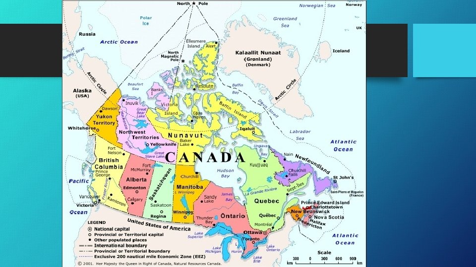
Canada (Overview) • Land—Canada has the second-largest land area in the world, with 3, 855, 174 square miles, and the longest coastline, which includes over 50, 000 islands. • Population—Around 90% of Canadians live within 100 miles of the U. S. -Canada border. This border is the longest unfortified border in the world. • [G-Now] https: //www. youtube. com/watch? v=Sxh. Us. PBFPk. U
Newfoundland (& Labrador)
Newfoundland • Maritime Province—Newfoundland is one of four “Maritime” provinces, which means, “bordering the sea. ” • Physical Geography—Newfoundland is composed of a rocky island part of the Canadian continent. In 1964, the province was renamed, “Newfoundland Labrador” to give both parts of the province honor. • The Grand Banks—The capital of Newfoundland, St. John’s, sits beside the famous fishing grounds, the Grand Banks. John Cabot reported that there were enough fish to feed his people “till the end of time. ” • [How Powerful is Canada? ] https: //www. youtube. com/watch? v=Yft. GSd. S 9 o 9 k
Newfoundland (Continued) • History—Europeans built their first settlement in the New World in Newfoundland with a Viking outpost dating back to A. D. 1000. Although Britain claimed the island in 1583, but Newfoundland didn’t actually join Canada until 1949, making it the last province to join the Confederation. • Labrador—Temperatures are so low in Labrador that it gave Clarence Birdseye the idea that freezing food would keep it from spoiling (since fish stayed edible for long periods of time there). • Newfoundland Standard Time—Canada has 6 time zones, and Newfoundland is oddly an hour and a half ahead of the EST zone. • [Video, ? 1: 53] https: //www. youtube. com/watch? v=Ncjgmnjke. M 0
Nova Scotia
Nova Scotia • [Video] https: //www. youtube. com/watch? v=n 1 VV 1 yj. Cf. S 0 • French Origins—The French settled the three southernmost Maritime Provinces, and called the region Acadia. They established the first French settlement in the New World, Port Royal, on the Bay of Fundy in Nova Scotia. • Nova Scotia—This phrase literally means “New Scotland” for its Scottish inhabitants and comparable geography to the Motherland. • Evangeline—This was the poem by Henry Wadsworth Longfellow that helped make Acadia famous. It described the contentions between the Scottish and French settlers over land, eventually leading to wars and then the Treaty of Utrecht (1713). After these legal agreements didn’t seem to work, the British sent the French Acadians away to places like New Orleans, where they were called “Cajuns. ”
Nova Scotia (Continued) • [The Canso Causeway] This connects the peninsula to Cape Breton Island, off the northeast corner.
Halifax • Capital—Halifax is the capital city of Nova Scotia, which has forests that provide many of the Christmas trees sold each year in Canada and around the world. • Halifax Explosion—On December 6, 1917, a French ship carrying explosives collided with another ship, killing 2000 residents and sailors. The blast leveled much of the northern section of the city. • [Video] https: //www. youtube. com/watch? v=rw-Fbwmz. PKo
New Brunswick
New Brunswick • French Background—French Acadians compose about 40% of New Brunswick’s population, which is the second largest percentage in Canada (behind Quebec). • “American” Background—Many others come from British or Loyalist ancestry, leading back to the American Revolutionary War when thousands fled to New Brunswick is the only Maritime Province that shares a border with the United States. • Bay of Fundy—This bay is situated between Nova Scotia and New Brunswick. It has the highest tides in the world, rising and falling an average of 47 feet every 12 hours! • [Video] https: //www. youtube. com/watch? v=vo. Eixel 2_t. Y
Prince Edward Island
Prince Edward Island • P. E. I. —This tiny island in the Gulf of St. Lawrence is the smallest Canadian province, barely larger than the state of Delaware. • Farming—Its farmland supports the highest population density of any province in Canada, but at about 62 people per square mile, it is still very rural. It’s sometimes called Canada’s “Million-Acre Farm. ” • Anne of Green Gables—L. M. Montgomery’s novel, Anne of Green Gables, is based on life in this province—the house at Cavendish, PEI is still there. • Confederation Bridge—This bridge was built in 1996 to connect PEI to the mainland, a decision opposed by some residents who wanted a more quaint lifestyle. • [Video, sk 5: 20 -29] https: //www. youtube. com/watch? v=_5 IYFSVr. Gh. M
“Mac” • Scottish Heritage—A majority of the islanders have a Scottish heritage, more over half of their last names beginning with “Mac. ” This word literally means “son of…” One will still find Scottish festivals here, full of bagpipes and kilts.
The Central Provinces • Cities—Most Canadian cities are on the southern strip of the nation, where temperatures are less severe. The Central Provinces include some of the larger and most populated regions. • The Canadian Shield—This solid mass of hard rock covers most of eastern Canada, and rims Hudson Bay like a giant horseshoe. While the soil is poor, there are many rich natural resources. • [Video] https: //www. youtube. com/watch? v=L 5 R 2 rz. Rhg 5 Q • Taiga & Tundra—While coniferous forests, called taiga, cover most of the Central Provinces, the northernmost extremes include most tundra (and no trees).
Taiga
Quebec
Quebec • New France—Canada’s earliest European explorers came from France. They mapped out the St. Lawrence and Great Lakes regions, which they termed New France. The French and British fought sporadically over this furtrading region, ending finally in Britain’s favor during the Seven Years’ War. • Melting Pot vs. Mosaic—Many American cities are viewed as being “melting pots, ” but in Canada, they take pride in their cultural “mosaics. ” The French have retained much of their heritage in Quebec, even making French the official language of the province in 1974. • [Video] https: //www. youtube. com/watch? v=XXhmblz. SAe. U
Quebec’s Cities • Quebec City—It was founded in 1608 as the cradle of French civilization in the New World. It still has an old-Europe charm to its appearance. • Montreal—This largest city of the province was explored by Jacques Cartier, who named the island “Mont Real, ” which is translated to mean, “Royal Mountain. ” Montreal is more much bilingual, compared to Quebec. • [Video] https: //www. youtube. com/watch? v=Vkj 7_Bzmhvc • Underground Mall—Montreal houses a vast underground mall, with stores, restaurants, and businesses, and even a subway called a “Metro. ”
Hockey • Hockey—It is the national sport of Canada. • Origins—Soldiers invented the game of hockey in the 1850 s. Many believe it was first played in Kingston, Ontario, but some Montreal residents believe their city birthed the game. • Question—Why is the NHL (National Hockey League) not called the IHL? • [Video] https: //www. youtube. com/watch? v=z. TZd 7 Mk. SNHs
Ontario • Importance—Ontario ranks second in size among Canadian provinces, but it is first in population. Some call Ontario the “Heartland” of Canada. While Quebec bears a French heritage, Ontario is much more British. • Northern Ontario—Few people live in Ontario’s cold north, as the Canadian Shield covers about half of the province. The word “Ontario” comes from an Iroquois word meaning, “shining waters. ” • Southern Ontario—Many more people live in this region of Ontario. The city of Windsor is even farther south than Boston, MA. Also, just as Michigan became America’s auto leader, so too did Ontario become the auto powerhouse of Canada.
Ontario (Continued) • Great Lakes Plain—Half of Canada’s twenty largest cities lie in the Great Lakes Plain, with Toronto being the hub. • Toronto—It is the capital of Ontario, and is the largest metropolitan area in the country. Toronto is also the nation’s leading commercial center. This city shares Niagara Falls with the state of New York. • [Video] https: //www. youtube. com/watch? v=7 u. Y 0 Ab 5 Hl. Z 0 • Ottawa—It is the national capital, though not in the Great Lakes Plain as it is further east.
Canadian Independence • History—In 1837, colonists in Upper Canada (Quebec) and Lower Canada (Ontario) rebelled against Great Britain, wanting more democracy. The British government wanted to avoid another war with colonists, so they granted the Province of Canada (both Upper & Lower combined) the right to govern its internal affairs. • British North America Act—This law established a confederation of 4 provinces in 1867 (Ontario, New Brunswick, Quebec, and Nova Scotia). Since then, 6 other provinces have joined the confederation. • [Video] https: //www. youtube. com/watch? v=ks. YSCWp. FKBo
Canadian Government • Background—The Dominion of Canada is modeled after the British parliamentary system, as they have a House of Commons and a Senate. • Independence—While Canada operates independently from Britain, it is still part of the British Commonwealth, which recognizes the monarch as “head of state. ” • Prime Minister—He/she runs the executive branch of government (like the U. S. president), but also chooses the country’s senators and is the speaker in the House of Commons. • Governor General—He/she is appointed by the prime minister and represents Canada in England’s Parliament. • [Video] https: //www. youtube. com/watch? v=7 C 8 u. Duh. Lqvg
Western Provinces • West vs. East—The 4 Western Provinces were settled much later than those in the East, and it still retains a frontier spirit. • Trans-Canada Highway—This 4, 860 mile highway links both ends of the country. • [Video] https: //www. youtube. com/watch? v=Nqp. Sw 7 Rls 4 A • Climate & Weather—While summer temperatures can climb to 100, winter nights often hit below 0 degrees. Since the plains lie in the shadow of the Rocky Mountains, rainfall is also scarce.
Manitoba • Land of Lakes—Two strings of lakes straddle the center of the province, with Lake Winnipeg to the east, and Lakes Manitoba and Winnipego to the west. • Metis—Descendants of French men and Indian women once lived by hunting the bison along the plains. In 1812, the metis attacked and killed numerous Scottish and Irish immigrants. Another incident happened in 1867 with the Red River Rebellion, which lead to a bill of rights being drawn in 1870, and the creation of Canada’s 5 th province: Manitoba. • Churchill—This town in northern Manitoba is the “Polar Bear Capital of the World. ” • [Video] https: //www. youtube. com/watch? v=VZD 5 YK-u. C-Q
Saskatchewan • Canada’s Breadbasket—The Saskatchewan Plain is in the southern half of the province, and with the wheat farms there, it is called “Canada’s Breadbasket. ” In fact, it is all of North America’s leading wheat producer. • Borders—Saskatchewan was part of the Northwest Territory until 1905, when it became a province. It is the only province made up of clear geometric borders. • Socialism—Dispirited farmers helped form the first socialist government in North America, running from 1944 to 1961. • [Video] https: //www. youtube. com/watch? v=e 2 j. XKUXSaw
Alberta • Resources—Alberta is a leading Canadian producer of barley and has the most beef cattle of any province. The northeastern tip is noted to have oil reserves that exceed the amount available in Saudi Arabia. • Cities—The capital of Alberta is Edmonton, but Calgary is the gateway to the Canadian Rockies, and is a popular tourist location. The latter city also has an annual rodeo (see page 123). • [Video, stop @ 3: 18] https: //www. youtube. com/watch? v=-s 3 M 4 m. Co 594
British Columbia • Pacific Ocean—British Columbia is the only province on the Pacific Ocean, and was not discovered by Britain until 1778. • Western Cordillera—This chain of mountains extends from Alaska all the way to South America, and covers much of British Columbia. • Vancouver—It is the largest city in British Columbia, and is located at the mouth of the Fraser River, which empties into the Pacific Ocean. This city grew in large part to the country’s first transcontinental railroad in the late 1800 s. • [Video] https: //www. youtube. com/watch? v=p. CQQWRs 9 m 24
Yukon Territory • Northern Territories—More than 40% of Canada’s land is located in its northern territories, but the population is incredibly small due in large part to the chilly climate. • Eskimos—In the latest survey (2006), it was discovered that the Eskimo population has increased by 26% since the previous survey (10 years earlier), and number over 50, 000. • Gold—Yukon Territory became famous for its gold rushes in the 1890 s. It borders Alaska. • [Video] https: //www. youtube. com/watch? v=9 C 3 KAl. Mrw. DE • The Alaska Highway—Also called the Alcan Highway, it was originally created to help transport military supplies during WWII.
Northwest Territories • Size—This vast territory covers 1/3 of the country, but not even 50, 000 people live here. • Great Slave Lake—A good percentage of the population lives in Yellowknife, which stands beside the Great Slave Lake, the deepest North American lake. • Alexander Mackenzie—He was a trapper who first explored the length of the now-called “Mackenzie River” in the Northwest Territories. • [Video M 0: 49] https: //www. youtube. com/watch? v=Czh 5 CZfui. Yo
Nunavut • History—On May 4, 1992, the Northwest Territories approved a plan to split the territory in April of 1999 in order to allow native self-government. • Name—The new territory, Nunavut, is derived from the Inuit language, and means, “our land. ” Only 28 small villages exist in this vast, frozen wilderness. • Baffin Island—This is the largest island in the Canadian archipelago, and the 5 th largest island in the whole world. • [Video] https: //www. youtube. com/watch? v=og. NDCGDa_U 8
Physical Geography & Demographics of the United States Part 2
Boundaries • US-Canada Border—The United States and Canada share the longest non-militarized border in the world (5, 525 miles +). On average 300, 000 people cross the border each day. • [Video] https: //www. youtube. com/watch? v=q. Mk. Yl. IA 7 mgw • US-Mexican Border—The United States and Mexican border are separated by the Rio Grande, and then continues west across the states of New Mexico, Arizona, and California. • The Lower 48 States—There a few different names to refer to the “lower 48 states” of the U. S. The most common are “contiguous” and “conterminous. ” Contiguous will be used in these lectures.
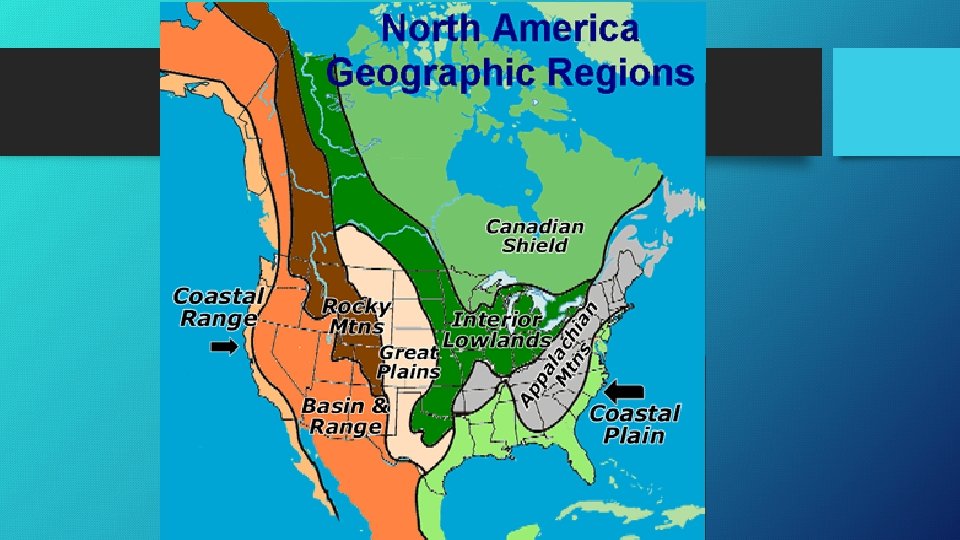
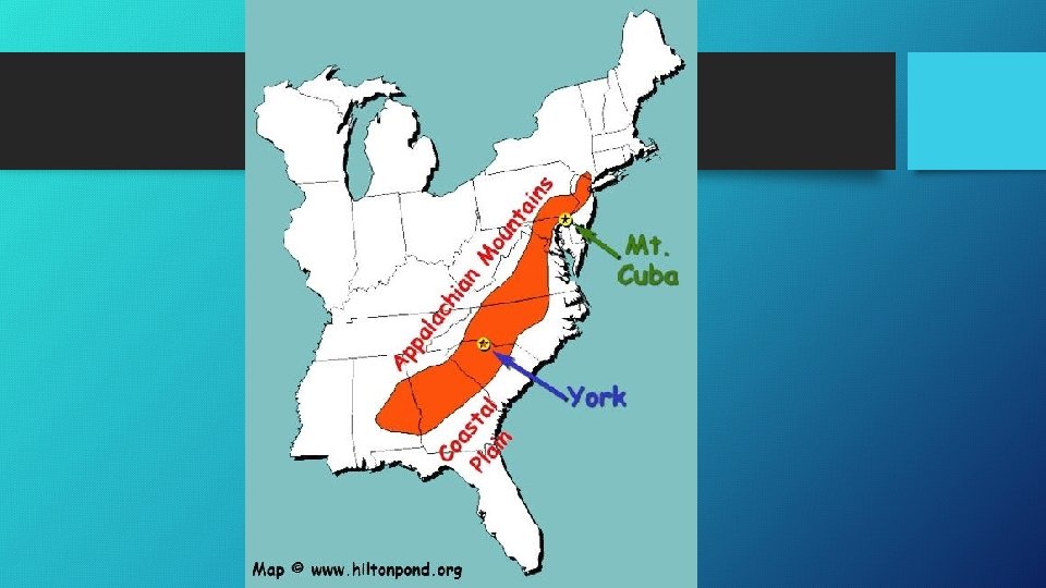
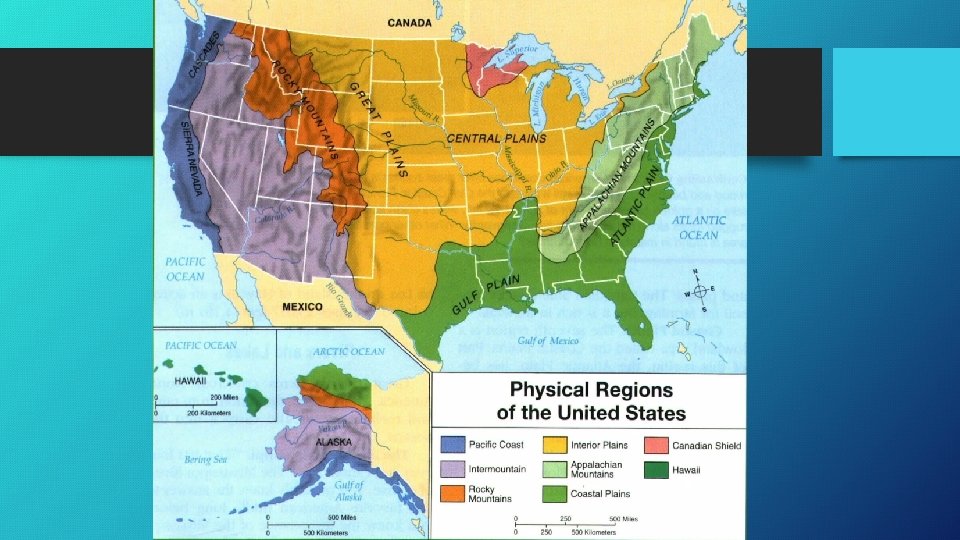
8 Topographical Regions (Contiguous U. S. ) • 1 - The Coastal Plains • 2 - The Piedmont • 3 - The Appalachian Mountains • 4 - The Central Plains • 5 - The Great Plains • 6 - The Rocky Mountains • 7 - The Great Basin • 8 - The Pacific Mountain Ranges …See page 135
The Coastal Plains • Coastal Plains—There are two regions of the Coastal Plains: (1) Along the Atlantic Ocean (2) Along the Gulf of Mexico. They have low elevation, some areas are swampy, but are often fertile. • Atlantic Coastal Plain—New York, Boston, and Philadelphia are all examples of harbors that exist along the Atlantic Coastal Plain. • [Boston, stop @ 5: 34] https: //www. youtube. com/watch? v=e 5 cm 2 SDu. Hx. A • Gulf Coastal Plain—Some port cities along this plain include: Wilmington, NC; Charleston, SC; Savannah, GA; Tampa, FL; New Orleans, LA. • Historical Importance—Looking back in world history, a significant amount of people have migrated to port cities. Can you name some? Why did this happen?
The Piedmont • Piedmont—This term refers to the area that is in the “foothills” of the Appalachian Mountains. • Length—The Piedmont stretches from parts of Maine to Alabama. • Cotton—The fertile ground is ideal for cotton (what are the historical implications? ) • [Video] https: //www. youtube. com/watch? v=QYa 4 zne. Kbe. Y
The Appalachian Mountains • Eastern Continental Divide—The Appalachian Mountains form the “Eastern Continental Divide. ” Water that flows east empties into the Atlantic Ocean, while water that flows west goes into the Great Lakes or the Mississippi River. • Significance—These mountains are covered by trees and have played a major role in history, both as an obstacles to western expansion and a partial barrier during the Civil War. • [Video] https: //www. youtube. com/watch? v=1 FE-Bgd. V-UU
The Central Plains • Location—The Central Plains are just west of the Appalachian Mountains. • The Mississippi River—This river and its tributaries have provided numerous water transportation routes throughout history. • [Video] https: //www. youtube. com/watch? v=541 t. R 66 rd. WM
The Great Plains • Location—The Great Plains lie west of the Central Plains. • Soil—The Great Plains are characterized by flat grasslands and a dry climate. It was originally called the “Great American Desert, ” but irrigation techniques have allowed the soil to be used for farming. • [Video] https: //www. youtube. com/watch? v=p. QKwzh. EXLEo
The Rocky Mountains • Elevation—The peaks here exceed 10, 000 feet, with the tallest point being at Mount Elbert at 14, 433 feet in elevation. • Western Continental Divide—The Rockies form the Western Continental Divide. Waters flow east and west of these mountains. Lewis and Clark were the American explorers that discovered this region as they traveled along the Missouri River. • [Video] https: //www. youtube. com/watch? v=VC 0 Pf 3 s. E 6 h. Q
The Great Basin • Region—The Great Basin is located between the Rocky Mountains, the Columbia and Colorado Plateaus, the Sonoran Desert, and Pacific mountain ranges. Nevada and a Large part of Utah make up a majority of this region.
The Pacific Mountain Ranges • Ranges—This region includes the Sierra Nevada, the Cascade Mountains (Oregon and Washington), and the Coastal Ranges (all along the Pacific coast). • Mount St. Helens—These ranges do possess some active volcanoes, including Mount St. Helens, which erupted in 1980. There have even been minor eruptions since then. • Silicon Valley—This valley region is located within the broader “Central Valley. ” Here, the technology industry has flourished since World War II. • [Video, sk 9: 55 -10: 00; M 11: 04] https: //www. youtube. com/watch? v=Lc. Oo. QP 7 nhl 4 • [Link] https: //www. quora. com/What-are-the-biggest-Silicon-Valleycompanies
Alaska • Largeness—Alaska is the largest state in the U. S. by far. At 570, 641 square miles, it is over twice the size of Texas. • Seward’s Folly—Although Russia originally annexed Alaska, the U. S. purchased the region while Russia was at war with Japan. Originally referred to as “Seward’s Folly, ” since William Seward initiated this purchase and it was thought to be an “ice box, ” gold was soon discovered. • Mt. Mc. Kinley—At 20, 237 feet, Mount Mc. Kinley is the highest point in North America. • [Video] https: //www. youtube. com/watch? v=jj. S 8 m. PJr 1 i. U
Hawaii • Location—Hawaii is the southernmost state of the U. S. , and is part of a chain of volcanic islands near the center of the Pacific Ocean. James Cook “discovered” these islands in 1779, originally naming them the “Sandwich Islands, ” after John Montague, the Earl of Sandwich (England). • [Video] https: //www. youtube. com/watch? v=_hy. E 2 NO 7 Hn. U
Resources • [page 139] • Group Exercise: After observing the map and statistics on page 139, provide 3 interpretations about how physical geography and natural resources are important in the United States and distinguish one region from the other. Use outside resources (Google) if necessary.
Religion • Christian Nation—Is America a “Christian nation”? • Stats: Protestants (28%), Catholics (21%), Other/Unspecified (7. 8%), Mormons (1. 7%), Jews (1. 7%), Other/Christian (1. 6%), Muslims (1. 6%), Buddhists (0. 7%). • Observations: • American is not a “Theocracy” or a New Israel • The Founders may have held to a lot of Christian morals, but not all were “Christians” (ex: Benjamin Franklin, Thomas Jefferson, John Quincy Adams) • If America was a “Christian nation, ” how did they justify the enslavement of a race? • Overall, America might be considered a nation that was founded on predominately Christian ideals (mixed with Enlightenment thought), but is still composed of many religious people, many of which are Christian (at least in name)
Core Values • Values—Core values forge a common culture and bind people together. There are 4 major values that have been prominent in American history: • • 1) 2) 3) 4) Freedom Equality Individualism Growth
Demographics • Immigration [pg. 144] – What are the causes to why certain people groups emigrated to the United States? • Age [pg. 145] • Race—The issue of race/racism in America has been hotly contested since its origins. The non-Anglo population is growing in all fifty states (which isn’t surprising since population is growing in the U. S. as a whole). It is estimated that by 2050, more than half of the nation’s population will be composed of minority groups.
Government & Economics • Government Form—America’s government operates as a federal republic. There are two levels of government: state government and federal government. • Economics—For more than 100 years, the United States operated under free enterprise capitalism, meaning that government played a limited role in regulating businesses. Over the last 100 years, however, government has played an increasing role (FDR’s “New Deal, ” LBJ’s “Great Society, ” Obamacare). Some have even pushed towards socialism (Bernie Sanders).
Regions of the United States Part 3
Flag Video • [Video NYP] https: //www. youtube. com/watch? v=v. TOx. Hy_wrpk
Regions Project • Each group will study their selected region • They will create and present a 5 -slide Powerpoint to the class • This will count as 25% of your final Test grade
The Northeast • Group 1
The South
The Midwest
The Plains
The West